Travelers to this area appeared in the early 19th century. Tom Boggs, a brother-in-law of Kit Carson, farmed at Wagon Wheel Gap in the summer of 1840. In 1869, the first silver discovery was made at the Alpha mine, but the silver could not be extracted at a profit from the complex ores. Ranchers and homesteaders moved in when stagecoach stations (linking the mining operations over the Divide with the east) were built in the 1870s. However, the great "Boom Days" started with the discovery of rich minerals in Willow Creek Canyon in 1889.[7][8][9][10][11][12]
Creede was originally located on East Willow Creek just above its junction with West Willow Creek, however, it was originally named Willow. The post office opened on May 12, 1891, and it was renamed Creede on July 1, 1891,[13] after Nicholas C. Creede who discovered the Holy Moses Mine.[14] Below Creede were Stringtown, Jimtown, and Amethyst. The Amethyst, Colorado, post office opened on January 25, 1892.[13] The Town of Creede was incorporated on May 19, 1892.[4] Soon the entire area from East Willow to Amethyst was called Creede.[15] The Creede, Colorado, post office moved to North Creede on November 28, 1908, where it remained open until April 15, 1919.[13] The Amethyst, Colorado, post office closed on February 2, 1909, but reopened as the new Creede, Colorado, post office on February 9, 1909.[13]
In the 19th century, Creede was the last silver boom town in Colorado. It leapt from a population of 600 in 1889 to more than 10,000 in December 1891. The Creede mines operated continuously from 1890 until 1985, and were served by the Denver & Rio Grande Railroad.[16]
While Creede was booming, the capital city of Denver, Colorado was experiencing a reform movement against gambling clubs and saloons. Numerous owners of gambling houses in Denver relocated to Creede's business district. One of these was confidence man Jefferson Randolph "Soapy" Smith. Soapy became the uncrowned king of Creede's criminal underworld, and opened the Orleans Club. Other famous people in Creede were Robert Ford (the man who killed outlaw Jesse James), Bat Masterson, and William Sidney "Cap" Light (the first deputy sheriff in Creede, and brother-in-law of Soapy Smith). On June 5, 1892, a fire destroyed most of the business district. Three days later, on June 8, Ed O'Kelley walked into Robert Ford's makeshift tent-saloon and shot him dead.[17][18] The town of Creede was incorporated on June 13, 1892. The anti-gambling movement in Denver had ceased, and the Denver businessmen moved back to their former areas of operation.[19]
Creede's boom lasted until 1893, when the Silver Panic hit the silver mining towns in Colorado. The price of silver plummeted, and most of the silver mines were closed.[20][21] Creede never became a ghost town, although the boom was over and its population declined. After 1900, Creede stayed alive by relying increasingly on lead and zinc in the ores.[22][23][24] Total production through 1966 was 58millionozt (1,800t) of silver, 150thousandozt (4.7t) of gold, 112 thousand metric tons of lead, 34 thousand metric tons of zinc, and 2 million metric tons of copper.[25]
Geography
Shallow Creek, west of Creede, CO
Creede is located near the headwaters of the Rio Grande, which flows through the San Juan Mountains and the San Luis Valley on its way to New Mexico, Texas, and eventually into the Gulf of Mexico.
The river has played a critical role in the development of farming and ranching in the Valley. The Rio Grande and its tributary trout streams provide excellent opportunities for fly fishermen and its unspoiled headwaters in the Weminuche Wilderness are a favorite for hikers.
As of the census[28] of 2000, there were 377 people, 181 households, and 106 families residing in the town. The population density was 622.4 inhabitants per square mile (240.3/km2). There were 275 housing units at an average density of 454.0 unitsper square mile (175.3 units/km2). The racial makeup of the town was 96.82% White, 1.33% Native American, and 1.86% from two or more races. Hispanic or Latino of any race were 1.59% of the population.
There were 181 households, out of which 19.3% had children under the age of 18 living with them, 46.4% were married couples living together, 8.8% had a female householder with no husband present, and 41.4% were non-families. 33.1% of all households were made up of individuals, and 12.2% had someone living alone who was 65 years of age or older. The average household size was 2.08 and the average family size was 2.70.
In the town, the population was spread out, with 19.1% under the age of 18, 5.0% from 18 to 24, 26.3% from 25 to 44, 33.7% from 45 to 64, and 15.9% who were 65 years of age or older. The median age was 45 years. For every 100 females, there were 100.5 males. For every 100 females age 18 and over, there were 98.1 males.
The median income for a household in the town was $30,893, and the median income for a family was $34,125. Males had a median income of $27,250 versus $17,250 for females. The per capita income for the town was $21,801. About 12.2% of families and 13.4% of the population were below the poverty line, including 31.0% of those under age 18 and 11.1% of those age 65 or over.
Arts and culture
Creede Fork, said to be the World's Largest
The Creede Fork, also known as the World's Largest Fork, is a 40-foot aluminum sculpture and roadside attraction in Creede built in 2012.[29] It is the largest fork in the United States, beating out the 35-foot-long (11m) fork in Missouri that previously held the record.[30] Created by artists Chev and Ted Yund, the fork is made of aluminum and weighs over 600 pounds (270kg).[31] In January 2018, it was named by The Daily Meal as the weirdest tourist attraction in Colorado.[32]
The fork was commissioned by Keith Siddel as a birthday present for his wife, Denise Dutwiler. Siddel hired two local artists, Chev and Ted Yund, to create the structure. The fork was designed specifically to out-measure the Giant Fork in Springfield, Missouri, which previously held the record of being the longest fork in the United States at a length of 35 feet.[33]
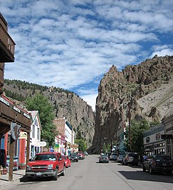
The Mainstage Theatre in 2023 with Creede's famous cliffs in the background.
The Creede Repertory Theatre was founded in 1966 by twelve University of Kansas students who answered the call from the Creede Junior Chamber of Commerce (Jaycees). It has since grown to a fully professional theatre company with an operating budget of over $1.5 million. Its annual production schedule includes a variety of plays, musicals, and new work, as well as musical events and concerts. Creede Rep is a true rotating repertory company which means that a visitor to the area can see up to five different shows in one weekend. In addition to these performances, the theatre offers a program for the development of new works, as well as nationally recognized and robust educational programming.[34] Creede Repertory Theatre has received many nominations fort its work by the Colorado Theatre Guild's Henry Awards including Best New Play, Best Scenic Design, and numerous nominations for individual performances.[35] Creede Repertory Theatre performs in two spaces, its historic Mainstage Theatre (originally a movie house in the 1930s) and the a more modern, flexible space that opened in 2011, the Ruth Humphreys Brown Theatre (The Ruth). Audiences can see shows and events in both spaces during the summer season and in The Ruth in October–April. [citation needed]
In popular culture
Poet and journalist Cy Warman wrote two poems about Creede, Creede[36] and The Rise and Fall of Creede.[37]
↑ Williams Jr., Albert (June 1892). "Creede, A New Mining Camp". The Engineering Magazine. III (3). New York, NY: McGraw Hill Publishing Co.: 324–339. Retrieved May 16, 2012.
↑ Parmelee, H.C. (December 1910). "Zinc Ore Dressing in Colorado - III". Metallurgical and Chemical Engineering. VIII (12). New York, NY: Electrochemical Publishing Co.: 677–680. Retrieved May 16, 2012.
↑ Henry C. Meeves and Richard P. Darnell (1968) Study of the Silver Potential, Creede District, Mineral County, Colorado, US Bureau of Mines, Information Circular 8370.
This page is based on this Wikipedia article Text is available under the CC BY-SA 4.0 license; additional terms may apply. Images, videos and audio are available under their respective licenses.