Baca County | |
---|---|
Coordinates: 37°19′N102°34′W / 37.32°N 102.56°W | |
Country | United States |
State | Colorado |
Founded | April 16, 1889 |
Named for | Felipe Baca |
Seat | Springfield |
Largest town | Springfield |
Area | |
• Total | 2,557 sq mi (6,620 km2) |
• Land | 2,555 sq mi (6,620 km2) |
• Water | 2.4 sq mi (6 km2) 0.09% |
Population (2020) | |
• Total | 3,506 [1] |
• Density | 1.4/sq mi (0.5/km2) |
Time zone | UTC−7 (Mountain) |
• Summer (DST) | UTC−6 (MDT) |
Congressional district | 4th |
Website | bacacountyco |
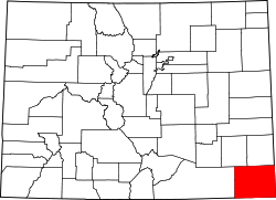
Baca County is a county located in the U.S. state of Colorado. As of the 2020 census, the population was 3,506. [1] The county seat is Springfield. [2] Located at the southeast corner of Colorado, the county shares state borders with Kansas, New Mexico, and Oklahoma.
Baca County was created by the Colorado legislature on April 16, 1889, out of eastern portions of Las Animas County. Baca County was named in honor of pioneer and Colorado territorial legislator Felipe Baca.
Prior to the 1880s there was little activity in the county, other than along the Cutoff Branch of the Santa Fe Trail that crosses its extreme southeastern corner. The 1910s saw wet years and expansion due to the increase in acreage that could be homesteaded. World War I also brought increased demand for agricultural products. The arrival of the Santa Fe Railroad in 1926 created new towns and a population increase.
The Dust Bowl arrived in the 1930s, with Baca County being one of the hardest hit areas. [3] This prompted soil conservation efforts by the federal government. Part of this effort was the purchase of cultivated land by the government in order to return it to grassland. Today the U.S. Forest Service supervises 220,000 acres of Comanche National Grassland which was purchased in the 1930s. These areas include Carrizo Creek and Picture Canyon. Colorado Parks and Wildlife maintains the recreational areas at Two Buttes Lake and Turk's Pond.
On May 18, 1977, an F4 tornado struck the southeastern portion of Baca County, causing an estimated $2.5 million in damage. It tracked from Keyes, Oklahoma, where damage was estimated at $25,000. [4] As of 2020, this is the only F4/EF4 tornado ever recorded in Colorado since 1950. [5] [6]
According to the U.S. Census Bureau, the county has a total area of 2,557 square miles (6,620 km2), of which 2,555 square miles (6,620 km2) is land and 2.4 square miles (6.2 km2) (0.09%) is water. [7]
Census | Pop. | Note | %± |
---|---|---|---|
1890 | 1,479 | — | |
1900 | 759 | −48.7% | |
1910 | 2,516 | 231.5% | |
1920 | 8,721 | 246.6% | |
1930 | 10,570 | 21.2% | |
1940 | 6,207 | −41.3% | |
1950 | 7,964 | 28.3% | |
1960 | 6,310 | −20.8% | |
1970 | 5,674 | −10.1% | |
1980 | 5,419 | −4.5% | |
1990 | 4,556 | −15.9% | |
2000 | 4,517 | −0.9% | |
2010 | 3,788 | −16.1% | |
2020 | 3,506 | −7.4% | |
2023 (est.) | 3,344 | [8] | −4.6% |
U.S. Decennial Census [9] 1790-1960 [10] 1900-1990 [11] 1990-2000 [12] 2010-2020 [1] |
As of the census [13] of 2000, there were 4,517 people, 1,905 households, and 1,268 families residing in the county. The population density was 2 people per square mile (0.77 people/km2). There were 2,364 housing units at an average density of 1 per square mile (0.39/km2). The racial makeup of the county was 93.73% White, 0.04% Black or African American, 1.20% Native American, 0.15% Asian, 0.09% Pacific Islander, 2.99% from other races, and 1.79% from two or more races. 7.02% of the population were Hispanic or Latino of any race.
There were 1,905 households, out of which 28.40% had children under the age of 18 living with them, 56.80% were married couples living together, 7.50% had a female householder with no husband present, and 33.40% were non-families. 30.40% of all households were made up of individuals, and 15.70% had someone living alone who was 65 years of age or older. The average household size was 2.33 and the average family size was 2.90.
In the county, the population was spread out, with 24.50% under the age of 18, 5.90% from 18 to 24, 22.70% from 25 to 44, 24.50% from 45 to 64, and 22.40% who were 65 years of age or older. The median age was 43 years. For every 100 females, there were 99.00 males. For every 100 females age 18 and over, there were 95.50 males.
The median income for a household in the county was $28,099, and the median income for a family was $34,018. Males had a median income of $23,169 versus $18,292 for females. The per capita income for the county was $15,068. About 12.90% of families and 16.90% of the population were below the poverty line, including 21.60% of those under age 18 and 13.30% of those age 65 or over.
The town is served by the Southeast Colorado Hospital. [14] Springfield Municipal Airport is located a few miles north of Springfield.
Like all of the High Plains, Baca County has long been overwhelmingly Republican. The last Democrat to carry the county was Lyndon Johnson in his 1964 landslide – when he carried all but three Colorado counties.
Year | Republican | Democratic | Third party(ies) | |||
---|---|---|---|---|---|---|
No. | % | No. | % | No. | % | |
2020 | 1,867 | 83.91% | 317 | 14.25% | 41 | 1.84% |
2016 | 1,753 | 81.42% | 283 | 13.14% | 117 | 5.43% |
2012 | 1,559 | 74.03% | 467 | 22.17% | 80 | 3.80% |
2008 | 1,572 | 72.28% | 536 | 24.64% | 67 | 3.08% |
2004 | 1,680 | 76.85% | 483 | 22.10% | 23 | 1.05% |
2000 | 1,663 | 73.00% | 531 | 23.31% | 84 | 3.69% |
1996 | 1,321 | 59.53% | 659 | 29.70% | 239 | 10.77% |
1992 | 1,240 | 47.29% | 726 | 27.69% | 656 | 25.02% |
1988 | 1,670 | 65.34% | 851 | 33.29% | 35 | 1.37% |
1984 | 1,903 | 75.85% | 580 | 23.12% | 26 | 1.04% |
1980 | 1,999 | 74.26% | 551 | 20.47% | 142 | 5.27% |
1976 | 1,303 | 51.97% | 1,164 | 46.43% | 40 | 1.60% |
1972 | 1,645 | 73.93% | 527 | 23.69% | 53 | 2.38% |
1968 | 1,441 | 57.55% | 719 | 28.71% | 344 | 13.74% |
1964 | 1,241 | 47.40% | 1,366 | 52.18% | 11 | 0.42% |
1960 | 1,815 | 65.48% | 952 | 34.34% | 5 | 0.18% |
1956 | 1,715 | 59.63% | 1,150 | 39.99% | 11 | 0.38% |
1952 | 2,122 | 65.57% | 1,094 | 33.81% | 20 | 0.62% |
1948 | 1,260 | 47.51% | 1,368 | 51.58% | 24 | 0.90% |
1944 | 1,528 | 61.89% | 941 | 38.11% | 0 | 0.00% |
1940 | 1,567 | 56.53% | 1,167 | 42.10% | 38 | 1.37% |
1936 | 1,288 | 39.46% | 1,797 | 55.06% | 179 | 5.48% |
1932 | 1,349 | 34.02% | 2,247 | 56.67% | 369 | 9.31% |
1928 | 2,108 | 78.48% | 524 | 19.51% | 54 | 2.01% |
1924 | 1,174 | 46.35% | 653 | 25.78% | 706 | 27.87% |
1920 | 1,615 | 63.21% | 695 | 27.20% | 245 | 9.59% |
1916 | 826 | 35.03% | 1,294 | 54.88% | 238 | 10.09% |
1912 | 318 | 28.24% | 430 | 38.19% | 378 | 33.57% |
1908 | 215 | 53.48% | 179 | 44.53% | 8 | 1.99% |
1904 | 203 | 60.60% | 130 | 38.81% | 2 | 0.60% |
1900 | 157 | 53.95% | 134 | 46.05% | 0 | 0.00% |
1896 | 125 | 47.71% | 135 | 51.53% | 2 | 0.76% |
1892 | 157 | 39.55% | 0 | 0.00% | 240 | 60.45% |
Sharkey County is a county located in the U.S. state of Mississippi. Part of the eastern border is formed by the Yazoo River. According to the 2020 census, the population was 3,800, making it the second-least populous county in Mississippi, after Issaquena County. Its county seat is Rolling Fork. The county is named after William L. Sharkey, the provisional Governor of Mississippi in 1865.
Prowers County is a county located in the U.S. state of Colorado. As of the 2020 census, the population was 11,999. The county seat is Lamar. The county is named in honor of John Wesley Prowers, a leading pioneer in the lower Arkansas River valley region.
Las Animas County is a county located in the U.S. state of Colorado. As of the 2020 census, the population was 14,555. The county seat is Trinidad. The county takes its name from the Mexican Spanish name of the Purgatoire River, originally called El Río de las Ánimas Perdidas en el Purgatorio, which means "River of the Lost Souls in Purgatory."
Harvest is an unincorporated community and census-designated place (CDP) in the northwestern part of Madison County, Alabama, United States, and is included in the Huntsville-Decatur Combined Statistical Area. According to the 2020 U.S. Census, the population of the community is 5,893.
Falkville is a town in Morgan County, Alabama, United States, and is included in the Decatur Metropolitan Area and Huntsville-Decatur Combined Statistical Area. As of the 2020 census, the population of the town was 1,197.
Campo is a Statutory Town located in Baca County, Colorado, United States. The town population was 103 at the 2020 United States Census. The town is situated on the High Plains, straddling U.S. Route 287/385.
Springfield is a Statutory Town which is also the county seat and most populous town in Baca County, Colorado, United States. The population was 1,325 at the 2020 census.
Henryville is a census-designated place (CDP) in Monroe Township, Clark County, in the U.S. state of Indiana. The population was 1,905 at the 2010 census.
Kennard is a town in Greensboro Township, Henry County, Indiana, United States. The population was 471 at the 2010 census.
Ryan is a city in Delaware County, Iowa, United States. The population was 350 at the time of the 2020 census.
Northboro is a city in Page County, Iowa, United States. The population was 52 at the time of the 2020 census.
Brandenburg is a home rule-class city on the Ohio River in Meade County, Kentucky, in the United States. The city is 40 miles (64 km) southwest of Louisville. It is the seat of its county. The population was 2,894 at the 2020 census.
Silver City is a town in Humphreys County, Mississippi, United States. The population was 217 at the 2021 census, a massive decline from the 2000 census.
Soso is a town in Jones County, Mississippi, United States. The population was 418 at the 2020 census.
Northwood is a city in Grand Forks County, North Dakota, United States. It is part of the "Grand Forks, ND-MN Metropolitan Statistical Area" or "Greater Grand Forks." The population was 982 at the 2020 census.
Union City is a town in Canadian County, Oklahoma, United States. The population was 1,645 at the 2010 census, a 19.6 percent increase from 1,375 in 2000. It is part of the Oklahoma City metropolitan statistical area.
Warr Acres is a city in Oklahoma County, Oklahoma, United States, and a part of the Oklahoma City metropolitan area. It was established after World War II by C.B. Warr, a dynamic businessman, builder, and commercial developer. The population was 10,452 at the 2020 census, a 4.1% increase from 2010.
Spencer is a city in McCook County, South Dakota, United States. The population was 136 at the 2020 census. The city was almost destroyed by a violent F4 tornado on May 30, 1998 which killed six people.
Fayetteville is a city in and the county seat of Lincoln County, Tennessee, United States. The population was 6,994 at the 2000 census, and 6,827 at the 2010 census. A census estimate from 2018 showed 7,017.
Eustace is a city in Henderson County, Texas, United States. The population was 1,137 at the 2020 census, up from 991 at the 2010 census.