Lycan, Colorado

Last updated

Lycan, Colorado
Lycan, Colorado.JPG
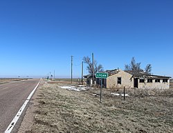
Looking east along State Highway 116 in Lycan
USA Colorado location map.svg
Red pog.svg
Lycan
Usa edcp location map.svg
Red pog.svg
Lycan
Coordinates: 37°36′55.05″N102°12′2.66″W / 37.6152917°N 102.2007389°W / 37.6152917; -102.2007389 [1]
Country United States
State Colorado
County Baca
Elevation
[1]
3,862 ft (1,177 m)
Time zone UTC−7 (MST)
  Summer (DST) UTC−6 (MDT)
ZIP Code
81084 [2] (Two Buttes)
Area code 719
FIPS code 08-46960 [1]
GNIS ID 196066 [1]

Lycan is an unincorporated community in Baca County, Colorado, United States. [1] It is located approximately 37 driving miles east-northeast of Springfield. [3]

Contents

History

The U.S. Post Office at Two Buttes (ZIP Code 81084) now serves Lycan postal addresses. [2]

Geography

Lycan is located at the junction of Colorado highways 89 and 116. [4]

The community is just over five miles from the state border with Kansas. [5]

References

  1. 1 2 3 4 5 "Lycan, Colorado", Geographic Names Information System , United States Geological Survey, United States Department of the Interior
  2. 1 2 "ZIP Code Lookup". United States Postal Service. January 3, 2007. Archived from the original (JavaScript/HTML) on November 22, 2010. Retrieved January 3, 2007.
  3. "Springfield, Colorado to Lycan, Colorado". Google Maps. Retrieved December 10, 2020.
  4. "DTD DataAccess - Statistics, Maps and Data - Highways Data". Archived from the original on April 16, 2011. Retrieved February 1, 2011.
  5. "Co Rd 57, Holly, CO to Lycan, Colorado". Google Maps. Retrieved December 10, 2020.