Campo, Colorado | |
---|---|
Coordinates: 37°06′17″N102°34′44″W / 37.104711°N 102.578798°W [2] | |
Country | United States |
State | Colorado |
County | Baca County [1] |
Incorporated | March 6, 1950 [3] |
Government | |
• Type | Statutory Town [1] |
Area | |
• Total | 0.144 sq mi (0.374 km2) |
• Land | 0.144 sq mi (0.374 km2) |
• Water | 0.000 sq mi (0.000 km2) |
Elevation | 4,344 ft (1,324 m) |
Population | |
• Total | 103 |
• Density | 713/sq mi (275/km2) |
Time zone | UTC−07:00 (MST) |
• Summer (DST) | UTC−06:00 (MDT) |
ZIP code | 81029 [6] |
Area code | 719 |
FIPS code | 08-11645 |
GNIS feature ID | 0196360 |
Website | www |
Campo is a Statutory Town located in Baca County, Colorado, United States. [1] The town population was 103 at the 2020 United States Census. [4] The town is situated on the High Plains, straddling U.S. Route 287/385.
Campo is a name derived from a Spanish word meaning "field". [7] A post office called Campo was established in 1913, [8] and the town grew around it.
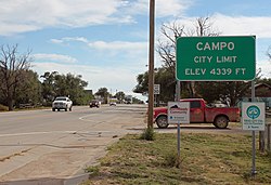
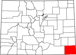
Campo is located just north of the Oklahoma border in southern Baca County at 37°06′17″N102°34′42″W / 37.104731°N 102.578394°W . [9] Via U.S. Route 287/385 it is 21 miles (34 km) north to Springfield, the county seat, and 27 miles (43 km) south to Boise City, Oklahoma.
At the 2020 United States Census, the town had a total area of 92 acres (0.374 km2), all of it land. [4]
Picture Canyon, in the Comanche National Grassland, is to the southwest. [10] The canyon includes scenic vistas, unique rock formations, rolling hills, and rock art from Plains Indian cultures. [11]
Climate data for Campo, Colorado | |||||||||||||
---|---|---|---|---|---|---|---|---|---|---|---|---|---|
Month | Jan | Feb | Mar | Apr | May | Jun | Jul | Aug | Sep | Oct | Nov | Dec | Year |
Average high °F (°C) | 47 (8) | 51 (11) | 59 (15) | 69 (21) | 78 (26) | 88 (31) | 93 (34) | 91 (33) | 83 (28) | 71 (22) | 58 (14) | 47 (8) | 69.5 (20.8) |
Average low °F (°C) | 22 (−6) | 25 (−4) | 32 (0) | 40 (4) | 51 (11) | 60 (16) | 66 (19) | 65 (18) | 56 (13) | 43 (6) | 32 (0) | 23 (−5) | 42.9 (6.1) |
Source: Accuweather [12] |
Census | Pop. | Note | %± |
---|---|---|---|
1950 | 266 | — | |
1960 | 235 | −11.7% | |
1970 | 206 | −12.3% | |
1980 | 185 | −10.2% | |
1990 | 121 | −34.6% | |
2000 | 150 | 24.0% | |
2010 | 109 | −27.3% | |
2020 | 103 | −5.5% | |
U.S. Decennial Census |
As of the census [13] of 2000, there were 150 people, 55 households, and 44 families residing in the town. The population density was 1,086.4 inhabitants per square mile (419.5/km2). There were 79 housing units at an average density of 572.2 per square mile (220.9/km2). The racial makeup of the town was 95.33% White, 3.33% Native American, and 1.33% from two or more races. Hispanic or Latino of any race were 4.67% of the population.
There were 55 households, out of which 40.0% had children under the age of 18 living with them, 70.9% were married couples living together, 5.5% had a female householder with no husband present, and 20.0% were non-families. 18.2% of all households were made up of individuals, and 10.9% had someone living alone who was 65 years of age or older. The average household size was 2.73 and the average family size was 3.11.
In the town, the population was spread out, with 30.7% under the age of 18, 4.7% from 18 to 24, 25.3% from 25 to 44, 22.7% from 45 to 64, and 16.7% who were 65 years of age or older. The median age was 38 years. For every 100 females, there were 105.5 males. For every 100 females age 18 and over, there were 92.6 males.
The median income for a household in the town was $20,875, and the median income for a family was $21,375. Males had a median income of $19,167 versus $19,375 for females. The per capita income for the town was $7,818. There were 33.3% of families and 45.6% of the population living below the poverty line, including 73.2% of under eighteens and 8.3% of those over 64.
The town was used as a location for a scene in the 1982 film Savannah Smiles .
Sedgwick County is a county located in the U.S. state of Colorado. As of the 2020 census, the population was 2,404. The county seat is Julesburg. The county was named for Fort Sedgwick, a military post along the Platte Trail, which was named for General John Sedgwick. It is located near the state border with Nebraska.
Saguache County is a county located in the U.S. state of Colorado. As of the 2020 census, the population was 6,368. The county seat is Saguache.
Prowers County is a county located in the U.S. state of Colorado. As of the 2020 census, the population was 11,999. The county seat is Lamar. The county is named in honor of John Wesley Prowers, a leading pioneer in the lower Arkansas River valley region.
Kit Carson County is a county located in the U.S. state of Colorado. As of the 2020 census, the population was 7,087. The county seat is Burlington. The county was established in 1889 and named for American frontiersman and Indian fighter Kit Carson.
Baca County is a county located in the U.S. state of Colorado. As of the 2020 census, the population was 3,506. The county seat is Springfield. Located at the southeast corner of Colorado, the county shares state borders with Kansas, New Mexico, and Oklahoma.
Springfield is a Statutory Town which is also the county seat and most populous town in Baca County, Colorado, United States. The population was 1,325 at the 2020 census.
Ward is a home rule municipality in Boulder County, Colorado, United States. The population was 150 at the 2010 census. The town is a former mining settlement founded in 1860 in the wake of the discovery of gold at nearby Gold Hill. Once one of the richest towns in the state during the Colorado Gold Rush, it is located on a mountainside at the top of Left Hand Canyon, near the Peak to Peak Highway northwest of Boulder at an elevation of 9,450 feet (2,880 m) above sea level.
Cheyenne Wells is the Statutory Town that is the county seat and the most populous municipality of Cheyenne County, Colorado, United States. The town population was 758 at the 2020 United States Census.
Brookside is a Statutory Town located in Fremont County, Colorado, United States. The town population was 236 at the 2020 United States Census.
Bethune is a Statutory Town located in Kit Carson County, Colorado, United States. The town population was 183 at the 2020 United States Census. It is located along U.S. Highway 24 that is north of an exit on Interstate 70.
The Town of Crook is a Statutory Town in Logan County, Colorado, United States. The town population was 133 at the 2020 United States Census. Crook is a part of the Sterling, CO Micropolitan Statistical Area.
The Town of Fleming is a Statutory Town in Logan County, Colorado, United States. The town population was 428 at the 2020 United States Census. Fleming is a part of the Sterling, CO Micropolitan Statistical Area.
The Town of Hillrose is a statutory town located in Morgan County, Colorado, United States. The town population was 312 at the 2020 United States Census, an 18.18% increase since the 2010 United States Census.
Holyoke is the home rule municipality that is the county seat and the most populous municipality of Phillips County, Colorado, United States. The city population was 2,346 at the 2020 United States Census.
Granada is a Statutory Town in Prowers County, Colorado, United States. The town population was 445 at the 2020 United States Census.
Hartman is a Statutory Town in Prowers County, Colorado, United States. The town population was 56 at the 2020 United States Census. The town is located North of SH-196.
Wiley is a Statutory Town in Prowers County, Colorado, United States. The population was 437 at the 2020 Census.
Eckley is a statutory town located in Yuma County, Colorado, United States. The town population was 232 at the 2020 United States Census.
El Campo is a city in Wharton County, Texas, United States. The population was 12,350 at the 2020 Census, making it the largest city in Wharton County.
Cleveland is a town in central Russell County, Virginia, United States. The population was 128 at the 2010 census.