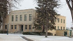
Holyoke, Colorado

Last updated
Holyoke, Colorado
Phillips County Courthouse.JPG
Phillips County Courthouse (2013)
Motto(s): 
"It's not what you show,
it's what you grow."
Phillips County Colorado Incorporated and Unincorporated areas Holyoke Highlighted 0837270.svg
Location of the City of Holyoke in Phillips County, Colorado.
Usa edcp location map.svg
Red pog.svg
Holyoke
Location of the City of Holyoke in the United States.
Coordinates: 40°34′55″N102°18′4″W / 40.58194°N 102.30111°W / 40.58194; -102.30111 Coordinates: 40°34′55″N102°18′4″W / 40.58194°N 102.30111°W / 40.58194; -102.30111
Country Flag of the United States.svg  United States
State Flag of Colorado.svg  Colorado
County Phillips County [1]
City Holyoke [1]
Incorporated May 31, 1888 [2]
Government
  Type Home Rule Municipality [1]
  MayorKevin Scott
Area
[3]
  Total2.476 sq mi (6.414 km2)
  Land2.470 sq mi (6.396 km2)
  Water0.007 sq mi (0.018 km2)
Elevation
[4]
3,750 ft (1,143 m)
Population
 (2020) [3]
  Total2,346
  Density950/sq mi (370/km2)
Time zone UTC−07:00 (MST)
  Summer (DST) UTC−06:00 (MDT)
ZIP code [5]
80734
Area code 970
FIPS code 08-37270
GNIS feature ID0182823
Website Holyoke CoC

Holyoke is the home rule municipality that is the county seat and the most populous municipality of Phillips County, Colorado, United States. [6] The city population was 2,346 at the 2020 United States Census. [3]

Contents

History

The city is named after Holyoke, Massachusetts, which is itself named for Elizur Holyoke, an explorer in the 17th-century. [7]

Geography

Oblique air photo from September 2018 Holyoke Colorado September 2018.jpg
Oblique air photo from September 2018

Holyoke is located at 40°34′55″N102°18′4″W / 40.58194°N 102.30111°W / 40.58194; -102.30111 (40.582002, -102.301056). [8]

At the 2020 United States Census, the town had a total area of 1,585 acres (6.414 km2) including 4.4 acres (0.018 km2) of water. [3]

Climate

According to the Köppen Climate Classification system, Holyoke has a cold semi-arid climate, abbreviated "BSk" on climate maps.

Climate data for Holyoke, Colorado, 19912020 normals, extremes 1897present
MonthJanFebMarAprMayJunJulAugSepOctNovDecYear
Record high °F (°C)76
(24)
80
(27)
89
(32)
91
(33)
99
(37)
110
(43)
110
(43)
107
(42)
105
(41)
98
(37)
88
(31)
80
(27)
110
(43)
Mean maximum °F (°C)64.0
(17.8)
68.0
(20.0)
77.6
(25.3)
84.0
(28.9)
90.7
(32.6)
97.5
(36.4)
100.3
(37.9)
98.1
(36.7)
94.6
(34.8)
86.9
(30.5)
75.4
(24.1)
64.9
(18.3)
101.8
(38.8)
Average high °F (°C)41.6
(5.3)
44.2
(6.8)
54.1
(12.3)
61.8
(16.6)
70.9
(21.6)
82.5
(28.1)
88.0
(31.1)
86.2
(30.1)
78.6
(25.9)
65.2
(18.4)
52.5
(11.4)
42.3
(5.7)
64.0
(17.8)
Daily mean °F (°C)27.2
(−2.7)
29.4
(−1.4)
38.4
(3.6)
46.4
(8.0)
56.7
(13.7)
67.8
(19.9)
73.3
(22.9)
71.1
(21.7)
62.6
(17.0)
49.0
(9.4)
37.0
(2.8)
27.6
(−2.4)
48.9
(9.4)
Average low °F (°C)12.7
(−10.7)
14.5
(−9.7)
22.7
(−5.2)
31.1
(−0.5)
42.5
(5.8)
53.1
(11.7)
58.6
(14.8)
56.0
(13.3)
46.6
(8.1)
32.9
(0.5)
21.4
(−5.9)
13.0
(−10.6)
33.8
(1.0)
Mean minimum °F (°C)−6.2
(−21.2)
−3.1
(−19.5)
6.8
(−14.0)
19.0
(−7.2)
29.1
(−1.6)
43.6
(6.4)
51.9
(11.1)
48.0
(8.9)
34.4
(1.3)
18.1
(−7.7)
6.5
(−14.2)
−4.3
(−20.2)
−13.0
(−25.0)
Record low °F (°C)−27
(−33)
−36
(−38)
−23
(−31)
−4
(−20)
8
(−13)
30
(−1)
37
(3)
36
(2)
16
(−9)
−12
(−24)
−12
(−24)
−35
(−37)
−36
(−38)
Average precipitation inches (mm)0.32
(8.1)
0.51
(13)
0.86
(22)
1.92
(49)
2.83
(72)
2.76
(70)
2.75
(70)
2.39
(61)
1.40
(36)
1.23
(31)
0.52
(13)
0.44
(11)
17.93
(456.1)
Average snowfall inches (cm)4.5
(11)
6.1
(15)
4.4
(11)
3.7
(9.4)
0.2
(0.51)
0.0
(0.0)
0.0
(0.0)
0.0
(0.0)
0.2
(0.51)
1.9
(4.8)
3.9
(9.9)
5.5
(14)
30.4
(76.12)
Average precipitation days (≥ 0.01 in)3.15.05.58.510.69.39.47.95.95.83.83.678.4
Average snowy days (≥ 0.1 in)2.74.02.91.80.20.00.00.00.11.02.33.318.3
Source 1: NOAA [9]
Source 2: National Weather Service [10]

Demographics

Historical population
CensusPop.Note
1890 649
1900 451−30.5%
1910 65946.1%
1920 1,20582.9%
1930 1,2261.7%
1940 1,150−6.2%
1950 1,55835.5%
1960 1,555−0.2%
1970 1,6405.5%
1980 2,09227.6%
1990 1,931−7.7%
2000 2,26117.1%
2010 2,3132.3%
2020 2,3461.4%
U.S. Decennial Census

As of the census [11] of 2000, there were 2,261 people, 896 households, and 594 families residing in the city. The population density was 1,300.3 inhabitants per square mile (502.0/km2). There were 980 housing units at an average density of 563.6 per square mile (217.6/km2). The racial makeup of the city was 89.61% White, 0.04% African American, 0.31% Native American, 0.57% Asian, 8.09% from other races, and 1.37% from two or more races. Hispanic or Latino of any race were 20.39% of the population.

There were 896 households, out of which 34.4% had children under the age of 18 living with them, 57.9% were married couples living together, 6.3% had a female householder with no husband present, and 33.7% were non-families. 30.6% of all households were made up of individuals, and 16.0% had someone living alone who was 65 years of age or older. The average household size was 2.47 and the average family size was 3.11.

In the city, the population was spread out, with 28.3% under the age of 18, 6.4% from 18 to 24, 26.6% from 25 to 44, 20.1% from 45 to 64, and 18.7% who were 65 years of age or older. The median age was 38 years. For every 100 females, there were 90.2 males. For every 100 females age 18 and over, there were 86.7 males.

The median income for a household in the city was $30,984, and the median income for a family was $36,970. Males had a median income of $30,500 versus $17,455 for females. The per capita income for the city was $15,697. About 12.0% of families and 14.6% of the population were below the poverty line, including 21.1% of those under age 18 and 8.4% of those age 65 or over.

Notable people

See also

Related Research Articles

<span class="mw-page-title-main">West Athens, California</span> Unincorporated community in California, United States

West Athens is a census-designated place (CDP) in Los Angeles County, California. The population was 9,393 at the 2020 census. It is an unincorporated community within the 2nd Supervisorial District of Los Angeles County. West Athens is served by the Los Angeles County Sheriff's Department, operating out of the South Los Angeles Station. The approximate boundaries for West Athens are: 87th Street to the north, Vermont Avenue to the east, El Segundo Boulevard to the south, and approximately Western Avenue to Van Ness Avenue to the west. West Athens is predominantly residential, with commercial uses along its main corridors. Los Angeles Southwest Community College lies within the West Athens neighborhood and city limits.

<span class="mw-page-title-main">Northglenn, Colorado</span> City in Colorado, United States

The City of Northglenn is a home rule municipality located in Adams and Weld counties, Colorado, United States. Northglenn is a part of the Denver–Aurora–Lakewood, CO Metropolitan Statistical Area. As of the 2010 census the city's population was 35,789. It was built as a master planned community in 1959 by Jordon Perlmutter.

<span class="mw-page-title-main">Springfield, Colorado</span> Town in Colorado, United States

Springfield is a Statutory Town which is also the county seat and most populous town in Baca County, Colorado, United States. The population was 1,451 at the 2010 census.

<span class="mw-page-title-main">Two Buttes, Colorado</span> Town in Colorado, United States

The town of Two Buttes is a Statutory Town located in Baca County, Colorado, United States. The population was 43 at the 2010 census.

<span class="mw-page-title-main">Walsh, Colorado</span> Town in Colorado, United States

Walsh is a Statutory Town in Baca County, Colorado, United States. The population was 546 at the 2010 census, down from 723 at the 2000 census.

<span class="mw-page-title-main">Kit Carson, Colorado</span> Town in Colorado, United States

Kit Carson is a Statutory Town in Cheyenne County, Colorado, United States. The population was 233 at the 2010 United States Census.

<span class="mw-page-title-main">Bethune, Colorado</span> Town in Kit Carson County, Colorado, United States

The Town of Bethune is a Statutory Town located in Kit Carson County, Colorado, United States. The town population was 183 at the 2020 United States Census.

<span class="mw-page-title-main">Burlington, Colorado</span> City in Colorado, United States

Burlington is a home rule municipality and the county seat and most populous community of Kit Carson County, Colorado, United States. The city population was 3,172 at the 2020 United States Census.

<span class="mw-page-title-main">Seibert, Colorado</span> Town in Kit Carson County, Colorado, United States

Seibert is a statutory town in Kit Carson County, Colorado, United States. The population was 181 at the 2010 census and is, as of 2018, estimated to be 216.

<span class="mw-page-title-main">Stratton, Colorado</span> Town in Kit Carson County, Colorado, United States

Stratton is a statutory town in Kit Carson County, Colorado, United States. The population was 658 at the 2010 census. Stratton was named in honor of the gold miner and philanthropist Winfield Scott Stratton.

<span class="mw-page-title-main">Crook, Colorado</span> Town in Colorado, United States

The Town of Crook is a Statutory Town in Logan County, Colorado, United States. The town population was 133 at the 2020 United States Census. Crook is a part of the Sterling, CO Micropolitan Statistical Area.

<span class="mw-page-title-main">Fleming, Colorado</span> Town in Colorado, United States

The Town of Fleming is a Statutory Town in Logan County, Colorado, United States. The town population was 428 at the 2020 United States Census. Fleming is a part of the Sterling, CO Micropolitan Statistical Area.

<span class="mw-page-title-main">Sterling, Colorado</span> City in Colorado, United States

Sterling is a home rule municipality and the county seat and most populous municipality of Logan County, Colorado, United States. Sterling is the principal city of the Sterling, CO Micropolitan Statistical Area. The city population was 13,753 at the 2020 census.

<span class="mw-page-title-main">Holly, Colorado</span> Town in Colorado, United States

The Town of Holly is a statutory town in Prowers County in southeastern Colorado, United States, near the Kansas border. Located four miles (6 km) from the Kansas border at an elevation of 3,392 feet (1,034 m), Holly is the lowest elevation town in Colorado. The town population was 837 at the 2020 United States Census.

<span class="mw-page-title-main">Ovid, Colorado</span> Town in Colorado, United States

Ovid is a statutory town in Sedgwick County, Colorado, United States. The population was 318 at the 2010 census.

<span class="mw-page-title-main">Sedgwick, Colorado</span> Town in Colorado, United States

Sedgwick is a statutory town in Sedgwick County, Colorado, United States. The population was 146 at the 2010 census.

<span class="mw-page-title-main">Otis, Colorado</span> Town in Colorado, United States

Otis is a Statutory Town in Washington County, Colorado, United States. The population was 475 at the 2010 census.

<span class="mw-page-title-main">Eckley, Colorado</span> Town in Colorado, United States

The Town of Eckley is a statutory town located in Yuma County, Colorado, United States. The town population was 232 at the 2020 United States Census.

<span class="mw-page-title-main">Wray, Colorado</span> City in Colorado, United States

Wray is the home rule municipality that is the county seat of Yuma County, Colorado, United States. Located in the Colorado Plains, the city is 170 miles east of Denver, 9 miles west of the Nebraska state line, and 25 miles northwest of the Kansas state line. The population was 2,358 at the 2020 United States census.

<span class="mw-page-title-main">Annona, Texas</span> Town in Texas, United States

Annona is a town in Red River County, Texas, United States. The population was 315 at the 2010 census.

References

  1. 1 2 3 4 "Active Colorado Municipalities". Colorado Department of Local Affairs . Retrieved December 28, 2021.
  2. "Colorado Municipal Incorporations". State of Colorado, Department of Personnel & Administration, Colorado State Archives. 2004-12-01. Retrieved 2007-09-02.
  3. 1 2 3 4 "QuickFacts for Colorado". United States Census Bureau . Retrieved December 28, 2021.
  4. "US Board on Geographic Names". United States Geological Survey. 2007-10-25. Retrieved 2008-01-31.
  5. "ZIP Code Lookup". United States Postal Service. Archived from the original (JavaScript/HTML) on November 4, 2010. Retrieved October 6, 2007.
  6. "Find a County". National Association of Counties. Archived from the original on 2011-05-31. Retrieved 2011-06-07.
  7. Gannett, Henry (1905). The Origin of Certain Place Names in the United States. Govt. Print. Off. pp.  159.
  8. "US Gazetteer files: 2010, 2000, and 1990". United States Census Bureau. 2011-02-12. Retrieved 2011-04-23.
  9. "U.S. Climate Normals Quick Access". National Oceanic and Atmospheric Administration. Retrieved August 8, 2022.
  10. "NOAA Online Weather Data". National Weather Service. Retrieved August 8, 2022.
  11. "U.S. Census website". United States Census Bureau . Retrieved 2008-01-31.