Craig, Colorado | |
---|---|
Coordinates: 40°31′01″N107°33′19″W / 40.51694°N 107.55528°W [2] | |
Country | United States |
State | Colorado |
County | Moffat County [3] |
Incorporated | July 15, 1908 [4] |
Government | |
• Type | Home rule municipality [1] |
Area | |
• Total | 5.073 sq mi (13.138 km2) |
• Land | 5.073 sq mi (13.138 km2) |
• Water | 0.000 sq mi (0.000 km2) |
Elevation | 6,195 ft (1,888 m) |
Population | |
• Total | 9,060 |
• Density | 1,786/sq mi (690/km2) |
• Metro | 13,292 |
• CSA | 38,121 |
Time zone | UTC−07:00 (MST) |
• Summer (DST) | UTC−06:00 (MDT) |
ZIP Codes [7] | 81625 & 81626 (PO Box) |
Area code | 970 |
FIPS code | 08-17760 |
GNIS feature ID | 2410255 [6] |
Website | www |
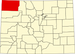
Craig is a home rule municipality that is the county seat and the most populous municipality of Moffat County, Colorado, United States. [1] The city population was 9,060 at the 2020 United States Census. [5] Craig is the principal city of the Craig, CO Micropolitan Statistical Area.
Founded by William H. Tucker, Craig was incorporated as a city on July 15, 1908. The town was named for one of the town's financial backers, Reverend William Bayard Craig. [8] [9]
Craig became the county seat when Moffat County was created out of the western portion of Routt County on February 27, 1911. In the same area as Craig, at the confluence of the Yampa River (then known as the Bear River) and Fortification Creek, were previous towns known as Yampa (as early as 1885) and Windsor (as early as 1878). In 1878, the area consisted of a number of ranches and at least two businesses: Himley's Ferry (which allowed crossing of the Yampa River) and Peck's Store (a one-room trading post).
In the 1970s and early 1980s, the largest power generation plant in Colorado [10] and several coal mines were constructed near Craig.
At the 2020 United States Census, the city had a total area of 3,246 acres (13.138 km2), all of which was land. [5]
Under the Köppen climate classification, Craig has a humid continental climate (Dfb). Summer days are hot with cool nights and very high diurnal temperature variation, while winters are cold and snowy with lows near zero.
The record high temperature is 101 °F (38 °C), which occurred first on July 9, 2021, July 10, 2021, and most recently July 17, 2023, while the record low is −51 °F (−46 °C), which occurred on February 6, 1989.
Climate data for Craig, Colorado, 1991–2020 normals, extremes 1981–present | |||||||||||||
---|---|---|---|---|---|---|---|---|---|---|---|---|---|
Month | Jan | Feb | Mar | Apr | May | Jun | Jul | Aug | Sep | Oct | Nov | Dec | Year |
Record high °F (°C) | 52 (11) | 61 (16) | 77 (25) | 81 (27) | 91 (33) | 99 (37) | 101 (38) | 98 (37) | 96 (36) | 86 (30) | 72 (22) | 59 (15) | 101 (38) |
Mean maximum °F (°C) | 43.4 (6.3) | 47.6 (8.7) | 63.1 (17.3) | 74.0 (23.3) | 81.9 (27.7) | 90.9 (32.7) | 95.0 (35.0) | 92.7 (33.7) | 87.7 (30.9) | 76.6 (24.8) | 63.6 (17.6) | 47.9 (8.8) | 95.4 (35.2) |
Mean daily maximum °F (°C) | 30.6 (−0.8) | 35.7 (2.1) | 48.2 (9.0) | 58.5 (14.7) | 69.1 (20.6) | 81.2 (27.3) | 89.2 (31.8) | 86.5 (30.3) | 77.2 (25.1) | 62.3 (16.8) | 46.6 (8.1) | 32.2 (0.1) | 59.8 (15.4) |
Daily mean °F (°C) | 16.8 (−8.4) | 22.2 (−5.4) | 34.0 (1.1) | 42.9 (6.1) | 51.8 (11.0) | 60.9 (16.1) | 68.3 (20.2) | 66.3 (19.1) | 57.1 (13.9) | 44.4 (6.9) | 31.8 (−0.1) | 18.7 (−7.4) | 42.9 (6.1) |
Mean daily minimum °F (°C) | 3.0 (−16.1) | 8.6 (−13.0) | 19.8 (−6.8) | 27.3 (−2.6) | 34.5 (1.4) | 40.6 (4.8) | 47.3 (8.5) | 46.0 (7.8) | 36.9 (2.7) | 26.4 (−3.1) | 17.1 (−8.3) | 5.3 (−14.8) | 26.1 (−3.3) |
Mean minimum °F (°C) | −21.3 (−29.6) | −18.0 (−27.8) | −1.0 (−18.3) | 12.8 (−10.7) | 22.6 (−5.2) | 30.3 (−0.9) | 37.4 (3.0) | 36.1 (2.3) | 24.2 (−4.3) | 11.6 (−11.3) | −3.0 (−19.4) | −18.0 (−27.8) | −27.6 (−33.1) |
Record low °F (°C) | −44 (−42) | −51 (−46) | −24 (−31) | −2 (−19) | 12 (−11) | 23 (−5) | 30 (−1) | 25 (−4) | 10 (−12) | −14 (−26) | −21 (−29) | −39 (−39) | −51 (−46) |
Average precipitation inches (mm) | 0.91 (23) | 0.89 (23) | 0.99 (25) | 1.67 (42) | 1.63 (41) | 0.99 (25) | 0.93 (24) | 0.97 (25) | 1.75 (44) | 1.48 (38) | 0.99 (25) | 0.90 (23) | 14.10 (358) |
Average snowfall inches (cm) | 15.5 (39) | 13.4 (34) | 12.2 (31) | 5.8 (15) | 0.8 (2.0) | 0.1 (0.25) | 0.0 (0.0) | 0.0 (0.0) | 0.3 (0.76) | 2.9 (7.4) | 10.6 (27) | 14.6 (37) | 76.2 (193.41) |
Average extreme snow depth inches (cm) | 11.2 (28) | 9.8 (25) | 6.6 (17) | 2.9 (7.4) | 1.0 (2.5) | 0.0 (0.0) | 0.0 (0.0) | 0.0 (0.0) | 0.0 (0.0) | 2.3 (5.8) | 5.0 (13) | 9.2 (23) | 12.9 (33) |
Average precipitation days (≥ 0.01 in) | 10.0 | 9.5 | 10.0 | 11.2 | 10.1 | 6.7 | 7.5 | 8.9 | 7.4 | 9.2 | 8.2 | 9.9 | 108.6 |
Average snowy days (≥ 0.1 in) | 8.3 | 6.4 | 5.6 | 2.4 | 0.6 | 0.1 | 0.0 | 0.0 | 0.1 | 1.4 | 5.3 | 6.9 | 37.0 |
Source 1: NOAA (snow/snow days 1981–2010) [11] [12] | |||||||||||||
Source 2: National Weather Service [13] |
Census | Pop. | Note | %± |
---|---|---|---|
1910 | 392 | — | |
1920 | 1,297 | 230.9% | |
1930 | 1,418 | 9.3% | |
1940 | 2,123 | 49.7% | |
1950 | 3,080 | 45.1% | |
1960 | 3,984 | 29.4% | |
1970 | 4,205 | 5.5% | |
1980 | 8,133 | 93.4% | |
1990 | 8,091 | −0.5% | |
2000 | 9,189 | 13.6% | |
2010 | 9,464 | 3.0% | |
2020 | 9,060 | −4.3% | |
U.S. Decennial Census |
As of the census [14] of 2000, there were 9,189 people, 3,525 households, and 2,432 families residing in the city. The population density was 1,886.6 inhabitants per square mile (728.4/km2). There were 3,851 housing units at an average density of 790.6 units per square mile (305.3 units/km2). The racial makeup of the city was 92.56% White, 0.30% African American, 0.96% Native American, 0.42% Asian, 0.02% Pacific Islander, 3.84% from other races, and 1.89% from two or more races. Hispanic or Latino of any race were 10.80% of the population.
There were 3,525 households, out of which 38.3% had children under the age of 18 living with them, 54.3% were married couples living together, 9.6% had a female householder with no husband present, and 31.0% were non-families. 25.9% of all households were made up of individuals, and 8.9% had someone living alone who was 65 years of age or older. The average household size was 2.53 and the average family size was 3.05.
In the city, the population was spread out, with 28.5% under the age of 18, 9.6% from 18 to 24, 30.1% from 25 to 44, 21.9% from 45 to 64, and 9.9% who were 65 years of age or older. The median age was 34 years. For every 100 females, there were 106.3 males. For every 100 females age 18 and over, there were 103.4 males.
The median income for a household in the city was $41,091, and the median income for a family was $45,504. Males had a median income of $38,038 versus $21,806 for females. The per capita income for the city was $18,140. About 6.9% of families and 8.6% of the population were below the poverty line, including 10.5% of those under age 18 and 6.5% of those age 65 or over.
Craig is the terminus of a Union Pacific Railroad (UP) branch line that connects with the UP main line at Bond. The line was originally built by the Denver and Salt Lake Railway to connect Denver with Salt Lake City but was only completed as far west as Craig. [15] As of August 2024 [update] , the Colorado Department of Transportation (CDOT) is studying state-run passenger train service between Denver and Craig via Winter Park and Steamboat Springs. [16]
U.S. 40 is the primary east–west highway serving Craig, while Colorado State Highway 13 runs south to Interstate 70 and north to the Wyoming border, where it becomes Wyoming State Highway 789 and eventually connects with Interstate 80.
Craig-Moffat Airport is the local airfield. Scheduled passenger jet airline service is available at the Yampa Valley Airport, located near the town of Hayden, 15 miles (24 km) east of Craig.
Steamboat Springs Transit's regional bus service has multiple daily roundtrips between Craig and Steamboat Springs via Hayden, Milner, and Steamboat II, [17] while CDOT's Bustang Outrider intercity bus service has one daily Craig–Denver roundtrip. [18]
Craig is, according to the local chamber of commerce, "Elk Hunting Capital of the World". [19]
Alamosa is a home rule municipality and the county seat of Alamosa County, Colorado, United States. The city population was 9,806 in the 2020 United States Census. The city is the commercial center of the San Luis Valley in south-central Colorado, and is the home of Adams State University.
Routt County is a county located in the U.S. state of Colorado. As of the 2020 census, the population was 24,829. The county seat is Steamboat Springs. Routt County comprises the Steamboat Springs, CO Micropolitan Statistical Area.
Moffat County is a county located in the U.S. state of Colorado. As of the 2020 census, the population was 13,292. The county seat is Craig. With an area of 4,751 square miles, it is the second-largest county by area in Colorado, behind Las Animas County.
Buena Vista is a Statutory Town located in Chaffee County, Colorado, United States. The town population was 2,855 at the 2020 United States Census.
Delta is a home rule municipality that is the county seat and the most populous municipality of Delta County, Colorado, United States. The town population was 9,035 at the 2020 United States Census. The United States Forest Service headquarters of the Grand Mesa, Gunnison, and Uncompahgre National Forests are located in Delta.
Eagle is the home rule municipality that is the county seat of Eagle County, Colorado, United States. The town population was 7,511 at the 2020 United States Census, a +15.41% increase since the 2010 United States Census. Eagle is the part of the Edwards, CO Micropolitan Statistical Area.
Penrose is a census-designated place (CDP) and post office located in and governed by Fremont County, Colorado, United States. The CDP is a part of the Cañon City, CO Micropolitan Statistical Area. The Penrose post office has the ZIP Code 81240. At the United States Census 2020, the population of the Penrose CDP was 3,685.
Sterling is a home rule municipality and the county seat and most populous municipality of Logan County, Colorado, United States. Sterling is the principal city of the Sterling, CO Micropolitan Statistical Area. The city population was 13,735 at the 2020 census.
Cortez is a home rule municipality that is the county seat and the most populous municipality of Montezuma County, Colorado, United States. The city population was 8,766 at the 2020 United States Census.
Dolores is a Statutory Town located in Montezuma County, Colorado, United States. The town population was 885 at the 2020 United States Census.
Fowler is a statutory town located in northwestern Otero County, Colorado, United States. The town population was 1,253 at the 2020 United States Census.
La Junta is a home rule municipality in, the county seat of, and the most populous municipality of Otero County, Colorado, United States. The city population was 7,322 at the 2020 United States Census. La Junta is located on the Arkansas River in southeastern Colorado 68 miles (109 km) east of Pueblo. The city is home to Otero College.
Manzanola is a Statutory Town in Otero County, Colorado, United States. The town population was 341 at the 2020 United States Census.
Rocky Ford is a statutory city located in Otero County, Colorado, United States. The population was 3,876 at the 2020 census.
Swink is a Statutory Town in Otero County, Colorado, United States. The population was 604 at the 2020 census.
Fairplay is a statutory town that is the county seat and the most populous municipality of Park County, Colorado, United States. The town population was 724 at the 2020 United States Census. Fairplay is located in South Park at an elevation of 9,953 feet (3,034 m). The town is the fifth-highest incorporated place in the State of Colorado. Fairplay is a part of the Front Range Urban Corridor.
The Town of Hayden is a home rule municipality located in Routt County, Colorado, United States. The town population was 1,941 at the 2020 United States Census. Hayden is a part of the Steamboat Springs, CO Micropolitan Statistical Area. The town sits along U.S. Highway 40 in the Yampa River Valley between Craig and Steamboat Springs. Hayden is located near the Yampa Valley Regional Airport, by which Hayden is one of the smallest communities in the U.S. to have mainline passenger jet service provided by American Airlines, Delta Air Lines, Southwest Airlines and United Airlines on a scheduled basis.
Steamboat Springs is a home rule municipality that is the county seat and the most populous municipality of Routt County, Colorado, United States. The population was 13,224 at the 2020 census. Steamboat Springs is the principal city of the Steamboat Springs Micropolitan Statistical Area, and it is the largest city in northwestern Colorado.
The Town of Moffat is a statutory town in Saguache County, Colorado, United States. The town population was 108 at the 2020 United States Census.
Bustang is an intercity bus service in the U.S. state of Colorado. Service began in 2015 and originally traveled between Denver and Colorado Springs, Fort Collins, and Glenwood Springs. Service has since been expanded to connect Grand Junction, Durango, Gunnison, Alamosa, Pueblo, Fairplay and Lamar among others. It is Colorado's first state-run bus service. Capital costs are paid for from various state and federal sources, and operating costs are covered 60% by fares. In 2023, the system had a ridership of 90,600, or about 1,800 per weekday as of the second quarter of 2024.