Kiowa, Colorado

Last updated

Kiowa, Colorado
Kiowa Colorado.JPG
Kiowa, Colorado
Elbert County Colorado Incorporated and Unincorporated areas Kiowa Highlighted 0840790.svg
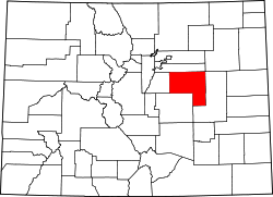
Location of Kiowa in Elbert County, Colorado.
Coordinates: 39°20′39″N104°27′46″W / 39.34417°N 104.46278°W / 39.34417; -104.46278
Country Flag of the United States.svg  United States
State Flag of Colorado.svg  State of Colorado
County Elbert County Seat [1]
Incorporated December 30, 1912 [2]
Government
  Type Home Rule Municipality [1]
Area
[3]
  Total0.86 sq mi (2.23 km2)
  Land0.86 sq mi (2.23 km2)
  Water0.00 sq mi (0.00 km2)
Elevation
[4]
6,378 ft (1,944 m)
Population
 (2020) [5]
  Total725
  Density840/sq mi (330/km2)
Time zone UTC-7 (MST)
  Summer (DST) UTC-6 (MDT)
ZIP code [6]
80117
Area code(s) Both 303 and 720
FIPS code 08-40790
GNIS feature ID 0185146
Website Official website

Kiowa is a home rule municipality town and the county seat of Elbert County, Colorado, United States. [7] The town population was 725 at the 2020 United States Census. [5]

Contents

History

The town was named for the Kiowa people. [8] Settled in 1859, it was originally named "Wendling" after an early settler. [9] It was called "Middle Kiowa" from the 1860s until 1912, [9] when it was incorporated and the word "Middle" was dropped. [10] It became the county seat of Elbert County in 1874. [9] Kiowa suffered from major flooding in 1935. [9]

Geography

Kiowa is located in western Elbert County at 39°20′39″N104°27′46″W / 39.34417°N 104.46278°W / 39.34417; -104.46278 (39.344207, −104.462714), [11] on the east side of Kiowa Creek, a north-flowing tributary of the South Platte River. Colorado State Highway 86 passes through the town, leading east 44 miles (71 km) to Limon and west 23 miles (37 km) to Castle Rock. The town of Elizabeth is 7 miles (11 km) west on SH 86.

According to the United States Census Bureau, Kiowa has a total area of 0.89 square miles (2.3 km2), all of it land. [12]

Demographics

Historical population
CensusPop.Note
1920 148
1930 18525.0%
1940 1955.4%
1950 173−11.3%
1960 19512.7%
1970 23520.5%
1980 206−12.3%
1990 27533.5%
2000 581111.3%
2010 72324.4%
2020 7250.3%
U.S. Decennial Census

Religion

See also

Related Research Articles

<span class="mw-page-title-main">Elbert County, Colorado</span> County in Colorado, United States

Elbert County is a county located in the U.S. state of Colorado. As of the 2020 census, the population was 26,062. The county seat is Kiowa and the largest town is Elizabeth.

<span class="mw-page-title-main">Bennett, Colorado</span> Town in Colorado, United States

Bennett is a Statutory Town located in Adams and Arapahoe counties, Colorado, United States. The town population was 2,862 at the 2020 United States Census with 2,443 residing in Adams County and 419 residing in Arapahoe County.

<span class="mw-page-title-main">Northglenn, Colorado</span> City in Colorado, United States

The City of Northglenn is a home rule municipality located in Adams and Weld counties, Colorado, United States. Northglenn is a part of the Denver–Aurora–Lakewood, CO Metropolitan Statistical Area. As of the 2020 census the city's population was 38,131. It was built as a master planned community in 1959 by Jordon Perlmutter.

<span class="mw-page-title-main">Bow Mar, Colorado</span> Town in Colorado, United States

Bow Mar is a Statutory Town located in Arapahoe and Jefferson counties, Colorado, United States. The town population was 853 at the 2020 United States Census with 587 residing in Arapahoe County and 266 residing in Jefferson County. Bow Mar is part of the Front Range Urban Corridor. The current mayor of Bow Mar is Bryan Sperry.

<span class="mw-page-title-main">Deer Trail, Colorado</span> Town in Colorado, United States

The Town of Deer Trail is a Statutory Town located in eastern Arapahoe County, Colorado, United States. The town population was 1,068 at the 2020 United States Census, a +95.60% increase since the 2010 United States Census. Deer Trail is a part of the Denver–Aurora–Lakewood, CO Metropolitan Statistical Area and the Front Range Urban Corridor. The town is situated along Interstate 70, approximately 55 miles (89 km) east of Denver.

<span class="mw-page-title-main">Foxfield, Colorado</span> Town in Colorado, United States

The Town of Foxfield is a statutory town located in Arapahoe County, Colorado, United States. The town population was 754 at the 2020 United States Census. Foxfield is a part of the Denver–Aurora–Lakewood, CO Metropolitan Statistical Area and the Front Range Urban Corridor. The town is bordered by the cities of Aurora and Centennial.

<span class="mw-page-title-main">Sheridan, Colorado</span> City in Colorado, United States

The City of Sheridan is a home rule municipality located in Arapahoe County, Colorado, United States. Sheridan is a part of the Denver–Aurora–Lakewood, CO Metropolitan Statistical Area. The population was 6,105 at the 2020 census.

<span class="mw-page-title-main">Larkspur, Colorado</span> Town in Colorado, United States

Larkspur is a home rule municipality in Douglas County, Colorado, United States. The town population was 206 at the 2020 census. Each year, on weekends in June, July and August, the Colorado Renaissance Festival is held in the hills just west of the town. The town is served by Larkspur Elementary School, a K-6 school in the Douglas County school district. The according to William Bright the town was named for the plains larkspur.

<span class="mw-page-title-main">Ramah, Colorado</span> Town in Colorado, United States

The town of Ramah is a Statutory Town in El Paso County, Colorado, United States. The population was 111 as of the 2020 census. According to tradition, the name is derived from India.

<span class="mw-page-title-main">Elizabeth, Colorado</span> Town in Elbert County, Colorado, United States

Elizabeth is a Statutory Town that is the most populous municipality in Elbert County, Colorado, United States. The town population was 1,675 at the 2020 United States Census, a +23.34% increase since the 2010 United States Census. Elizabeth is a part of the Denver–Aurora–Lakewood, CO Metropolitan Statistical Area and the Front Range Urban Corridor.

<span class="mw-page-title-main">Ponderosa Park, Colorado</span> Census Designated Place in Colorado, United States

Ponderosa Park is an unincorporated community and a census-designated place (CDP) located in and governed by Elbert County, Colorado, United States. The CDP is a part of the Denver–Aurora–Lakewood, CO Metropolitan Statistical Area. The population of the Ponderosa Park CDP was 3,334 at the United States Census 2020. Elbert County governs the unincorporated community. The Elizabeth post office serves the area.

<span class="mw-page-title-main">Lakeside, Colorado</span> Town in Colorado, United States

The Town of Lakeside is a Statutory Town in Jefferson County, Colorado, United States. The town population was 16 at the 2020 United States Census, making Lakeside the least populous municipality in the State of Colorado. Lakeside is immediately west of the City and County of Denver, the most populous municipality in the state. The Denver Post Office serves Lakeside.

<span class="mw-page-title-main">Keenesburg, Colorado</span> Town in Colorado, United States

The Town of Keenesburg is a Statutory Town in Weld County, Colorado, United States. The population was 1,250 at the 2020 United States Census.

<span class="mw-page-title-main">LaSalle, Colorado</span> Town in Colorado, United States

The Town of LaSalle is a Statutory Town in Weld County, Colorado, United States. The town population was 2,359 at the 2020 United States Census.

<span class="mw-page-title-main">Lochbuie, Colorado</span> Town in Colorado, United States

The Town of Lochbuie is a statutory town located in Weld and Adams counties in the U.S. state of Colorado. The town population was 8,088 at the 2020 United States Census.

<span class="mw-page-title-main">Nunn, Colorado</span> Town in Colorado, United States

Nunn is a Statutory Town in Weld County, Colorado, United States. The population was 504 at the 2020 census.

<span class="mw-page-title-main">Pierce, Colorado</span> Town in Colorado, United States

Pierce is a Statutory Town in Weld County, Colorado, United States. The population was 1,097 at the 2020 census. The town is a rural agricultural community located on the Colorado Eastern Plains along U.S. Highway 85 north of Greeley.

<span class="mw-page-title-main">Elbert, Colorado</span> Census Designated Place in Colorado, United States

Elbert is an unincorporated town, a post office, and a census-designated place (CDP) located in and governed by Elbert County, Colorado, United States. The CDP is a part of the Denver–Aurora–Lakewood, CO Metropolitan Statistical Area. The Elbert post office has the ZIP Code 80106. At the United States Census 2020, the population of the Elbert CDP was 188.

<span class="mw-page-title-main">Denver–Aurora combined statistical area</span> Place in Colorado, United States

The United States Office of Management and Budget has defined the 12-county Denver–Aurora, CO Combined Statistical Area comprising the Denver–Aurora–Lakewood, CO Metropolitan Statistical Area, the Boulder, CO Metropolitan Statistical Area, and the Greeley, CO Metropolitan Statistical Area. The United States Census Bureau estimates that the population was 3,214,218 as of July 1, 2012, an increase of +3.99% since the 2010 United States Census, and ranking as the 16th most populous metropolitan combined statistical area and the 17th most populous primary statistical area of the United States. The population estimate for 2020 was 3,652,385.

<span class="mw-page-title-main">North Central Colorado Urban Area</span> Metropolitan area of Colorado

The North Central Colorado Urban Area comprises the four contiguous metropolitan statistical areas in the north central region of the State of Colorado: the Denver–Aurora Metropolitan Statistical Area, the Boulder Metropolitan Statistical Area, the Fort Collins-Loveland Metropolitan Statistical Area, and the Greeley Metropolitan Statistical Area. With the exception of southeastern Elbert County, southeastern Park County, and tiny portions of southern Douglas County, the entire North Central Colorado Urban Area is drained by the South Platte River and its tributaries. The North Central Colorado Urban Area is the central, and the most populous, of the three primary subregions of the Front Range Urban Corridor.

References

  1. 1 2 "Active Colorado Municipalities". State of Colorado, Department of Local Affairs. Archived from the original on December 12, 2009. Retrieved December 6, 2007.
  2. "Colorado Municipal Incorporations". State of Colorado, Department of Personnel & Administration, Colorado State Archives. December 1, 2004. Retrieved September 2, 2007.
  3. "2019 U.S. Gazetteer Files". United States Census Bureau. Retrieved July 1, 2020.
  4. "US Board on Geographic Names". United States Geological Survey. October 25, 2007. Retrieved January 31, 2008.
  5. 1 2 United States Census Bureau. "Kiowa town; Colorado" . Retrieved April 24, 2023.
  6. "ZIP Code Lookup". United States Postal Service. Archived from the original (JavaScript/HTML) on November 4, 2010. Retrieved October 21, 2007.
  7. "Find a County". National Association of Counties. Archived from the original on May 31, 2011. Retrieved June 7, 2011.
  8. "Profile for Kiowa, Colorado, CO". ePodunk. Archived from the original on July 1, 2017. Retrieved July 14, 2012.
  9. 1 2 3 4 "Kiowa's story". Town of Kiowa. 2014. Retrieved October 7, 2015.
  10. "Kiowa, Colorado". City-Data.com. Retrieved July 13, 2012.
  11. "US Gazetteer files: 2010, 2000, and 1990". United States Census Bureau. February 12, 2011. Retrieved April 23, 2011.
  12. "Geographic Identifiers: 2010 Demographic Profile Data (G001): Kiowa town, Colorado". American Factfinder. U.S. Census Bureau. Archived from the original on February 13, 2020. Retrieved January 25, 2016.