This article needs additional citations for verification .(August 2024) |
Meeker, Colorado | |
---|---|
Motto: | |
Coordinates: 40°03′00″N107°53′40″W / 40.05000°N 107.89444°W | |
Country | United States |
State | State of Colorado |
County | Rio Blanco (County seat) [1] |
Founded | 1883 |
Incorporated | 1885-11-10 [2] |
Named for | Nathan Meeker |
Government | |
• Type | Statutory Town [1] |
• Mayor | Kent Borchard [3] |
Area | |
• Total | 3.59 sq mi (9.30 km2) |
• Land | 3.59 sq mi (9.30 km2) |
• Water | 0.00 sq mi (0.00 km2) |
Elevation | 6,444 ft (1,964 m) |
Population | |
• Total | 2,374 |
• Density | 660/sq mi (260/km2) |
Time zone | UTC-7 (MST) |
• Summer (DST) | UTC-6 (MDT) |
ZIP code [7] | 81641 |
Area code | 970 |
FIPS code | 08-49875 |
GNIS feature ID | 2412977 [5] |
Website | Town of Meeker |
Meeker is a statutory town in and the county seat of Rio Blanco County, Colorado, United States, that is the most populous municipality in the county. [8] The town population was 2,374 at the 2020 United States Census. [6]
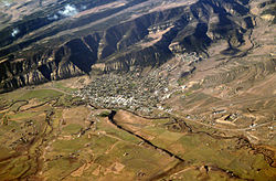
The town is largely a ranching community, located in the wide fertile valley of the White River in northwestern Colorado. Relatively isolated from other communities, it sits near the intersection of State Highway 13 and State Highway 64, on the north side of the White River and at the base of a long ridge, known locally as China Wall. The Bureau of Land Management has a regional office in the town. Meeker is the home of the annual Meeker Classic Sheepdog trials.
The town is named for Nathan Meeker, [9] the United States Indian Agent who was killed along with 11 other white citizens by White River Ute Indians in the 1879 Meeker Incident, also known as the Meeker Massacre. The site of the uprising, the former White River Indian Agency, is located along State Highway 64 in the White River valley west of town and is marked by a prominent sign. None of the buildings remain.
After the uprising and the ensuing conflict known as the Ute War, in 1880 the US Congress passed legislation requiring the Ute population to relocate to reservations in Utah. The United States Army established a garrison on the current site of the town, called the Camp at White River. The town was founded in 1883 following the removal of the troops. The White River Museum is located just north of the Rio Blanco County Courthouse and housed in several original wooden structures of the Army garrison.
The town emerged as a regional center for hunting by the turn of the 20th century. Theodore Roosevelt visited the town twice in 1901 and in 1905 on a mountain lion and bear hunting trip and stayed in the historic Hotel Meeker opposite the courthouse. The town is also a favorite summer destination and permanent residence for many prominent Americans, including billionaires Michael Bloomberg, former mayor of New York, Henry Kravis, former president and COO of Goldman Sachs Jon Winkelried, and comedian Daniel Tosh.
According to the United States Census Bureau, the town has a total area of 2.9 square miles (7.5 km2), all of it land. The town is situated on the White River at an elevation of 6,250 feet above sea level.
Census | Pop. | Note | %± |
---|---|---|---|
1890 | 260 | — | |
1900 | 507 | 95.0% | |
1910 | 807 | 59.2% | |
1920 | 935 | 15.9% | |
1930 | 1,069 | 14.3% | |
1940 | 1,399 | 30.9% | |
1950 | 1,658 | 18.5% | |
1960 | 1,655 | −0.2% | |
1970 | 1,597 | −3.5% | |
1980 | 2,356 | 47.5% | |
1990 | 2,098 | −11.0% | |
2000 | 2,242 | 6.9% | |
2010 | 2,475 | 10.4% | |
2020 | 2,374 | −4.1% |
According to the Köppen Climate Classification system, Meeker has a warm-summer humid continental climate, abbreviated "Dfb" on climate maps. The hottest temperature recorded in Meeker was 103 °F (39.4 °C) on July 11, 1900, while the coldest temperature recorded was −43 °F (−41.7 °C) on January 7, 1913, and January 12, 1963. [10]
Climate data for Meeker, Colorado, 1991–2020 normals, extremes 1893–present | |||||||||||||
---|---|---|---|---|---|---|---|---|---|---|---|---|---|
Month | Jan | Feb | Mar | Apr | May | Jun | Jul | Aug | Sep | Oct | Nov | Dec | Year |
Record high °F (°C) | 61 (16) | 65 (18) | 77 (25) | 86 (30) | 93 (34) | 102 (39) | 103 (39) | 99 (37) | 94 (34) | 86 (30) | 74 (23) | 63 (17) | 103 (39) |
Mean maximum °F (°C) | 48.3 (9.1) | 54.1 (12.3) | 66.6 (19.2) | 74.3 (23.5) | 82.4 (28.0) | 89.9 (32.2) | 94.0 (34.4) | 92.0 (33.3) | 87.1 (30.6) | 78.2 (25.7) | 66.1 (18.9) | 53.0 (11.7) | 94.8 (34.9) |
Mean daily maximum °F (°C) | 33.9 (1.1) | 39.2 (4.0) | 50.3 (10.2) | 58.1 (14.5) | 67.9 (19.9) | 79.4 (26.3) | 86.4 (30.2) | 83.5 (28.6) | 75.5 (24.2) | 62.7 (17.1) | 48.0 (8.9) | 35.1 (1.7) | 60.0 (15.6) |
Daily mean °F (°C) | 20.1 (−6.6) | 26.0 (−3.3) | 36.0 (2.2) | 42.9 (6.1) | 51.2 (10.7) | 60.7 (15.9) | 67.0 (19.4) | 64.9 (18.3) | 56.8 (13.8) | 45.0 (7.2) | 33.3 (0.7) | 21.7 (−5.7) | 43.8 (6.6) |
Mean daily minimum °F (°C) | 6.4 (−14.2) | 12.8 (−10.7) | 21.7 (−5.7) | 27.6 (−2.4) | 34.6 (1.4) | 40.9 (4.9) | 47.6 (8.7) | 46.2 (7.9) | 38.2 (3.4) | 27.3 (−2.6) | 18.6 (−7.4) | 8.4 (−13.1) | 27.5 (−2.5) |
Mean minimum °F (°C) | −15.3 (−26.3) | −9.7 (−23.2) | 3.8 (−15.7) | 12.9 (−10.6) | 21.6 (−5.8) | 30.8 (−0.7) | 38.1 (3.4) | 37.2 (2.9) | 25.6 (−3.6) | 12.4 (−10.9) | −2.8 (−19.3) | −14.4 (−25.8) | −19.9 (−28.8) |
Record low °F (°C) | −43 (−42) | −38 (−39) | −24 (−31) | −5 (−21) | 12 (−11) | 17 (−8) | 23 (−5) | 29 (−2) | 14 (−10) | −17 (−27) | −25 (−32) | −36 (−38) | −43 (−42) |
Average precipitation inches (mm) | 1.17 (30) | 0.99 (25) | 1.24 (31) | 1.96 (50) | 1.80 (46) | 1.02 (26) | 1.09 (28) | 1.44 (37) | 1.75 (44) | 1.74 (44) | 1.31 (33) | 1.20 (30) | 16.71 (424) |
Average snowfall inches (cm) | 13.7 (35) | 11.3 (29) | 8.7 (22) | 4.9 (12) | 0.6 (1.5) | 0.0 (0.0) | 0.0 (0.0) | 0.0 (0.0) | 0.2 (0.51) | 3.3 (8.4) | 9.9 (25) | 12.2 (31) | 64.8 (164.41) |
Average extreme snow depth inches (cm) | 11.2 (28) | 11.3 (29) | 6.9 (18) | 3.1 (7.9) | 0.8 (2.0) | 0.0 (0.0) | 0.0 (0.0) | 0.0 (0.0) | 0.1 (0.25) | 2.4 (6.1) | 5.3 (13) | 8.7 (22) | 13.3 (34) |
Average precipitation days (≥ 0.01 in) | 7.7 | 7.6 | 8.0 | 9.3 | 9.1 | 5.3 | 7.0 | 8.2 | 7.2 | 6.9 | 6.7 | 6.6 | 89.6 |
Average snowy days (≥ 0.1 in) | 7.2 | 5.5 | 4.2 | 2.5 | 0.3 | 0.0 | 0.0 | 0.0 | 0.1 | 1.3 | 4.7 | 6.3 | 32.1 |
Source 1: NOAA [11] | |||||||||||||
Source 2: National Weather Service [10] |
Rio Blanco County is a county located in the U.S. state of Colorado. As of the 2020 census, the population was 6,529. The county seat is Meeker. The name of the county is the Spanish name for the White River which runs through it.
Moffat County is a county located in the U.S. state of Colorado. As of the 2020 census, the population was 13,292. The county seat is Craig. With an area of 4,751 square miles, it is the second-largest county by area in Colorado, behind Las Animas County.
Delta is a home rule municipality that is the county seat and the most populous municipality of Delta County, Colorado, United States. The town population was 9,035 at the 2020 United States Census. The United States Forest Service headquarters of the Grand Mesa, Gunnison, and Uncompahgre National Forests are located in Delta.
Hotchkiss is a statutory town in Delta County, Colorado, United States. The population was 875 at the 2020 census.
Dove Creek is a statutory town that is the county seat and the most populous municipality of Dolores County, Colorado, United States. The town population was 635 at the 2020 United States Census. The community takes its name from the nearby Dove Creek. Dove Creek is the self-proclaimed Pinto Bean Capital of the World.
Rico is a town in Dolores County, Colorado, United States. It was settled in 1879 as a silver mining center in the Pioneer Mining District; today it functions as a historic and tourism site. The population was 288 at the 2020 census. Its current form of government is that of a home rule municipality.
Rifle is a home rule municipality in, and the most populous community of, Garfield County, Colorado, United States. The population was 10,437 at the 2020 census. Rifle is a regional center of the cattle ranching industry located along Interstate 70 and the Colorado River just east of the Roan Plateau, which dominates the western skyline of the town. The town was founded in 1882 by Abram Maxfield, and was incorporated in 1905 along Rifle Creek, near its mouth on the Colorado. The community takes its name from the creek.
La Veta is a statutory town in Huerfano County, Colorado, United States. La Veta sits at the base of the Spanish Peaks on the Highway of Legends National Scenic Byway. The town population was 862 as of the 2020 United States Census.
Walden is the Statutory Town that is the county seat, the most populous community, and the only incorporated municipality in Jackson County, Colorado, United States. It is situated in the center of a large open valley called North Park. People from Walden and the surrounding area refer to themselves as "North Parkers". The town population was 606 at the 2020 census. The town sits at an elevation of 8,099 feet. It was established in 1889 and was incorporated December 2, 1890. Mark A. Walden, an early postmaster, gave the community his name.
The Town of Merino is a Statutory Town in Logan County, Colorado, United States. The town population was 281 at the 2020 United States Census.
Sterling is a home rule municipality and the county seat and most populous municipality of Logan County, Colorado, United States. Sterling is the principal city of the Sterling, CO Micropolitan Statistical Area. The city population was 13,735 at the 2020 census.
De Beque is a statutory town located in Mesa County, Colorado. The population was 493 at the time of the 2020 census. De Beque is a part of the Grand Junction, CO Metropolitan Statistical Area. The town consists of a small grid, including a historic downtown featuring a town hall, a tavern, and several commercial businesses in historic structures. The surrounding streets include houses, several churches, and a school.
Craig is a home rule municipality that is the county seat and the most populous municipality of Moffat County, Colorado, United States. The city population was 9,060 at the 2020 United States Census. Craig is the principal city of the Craig, CO Micropolitan Statistical Area.
Rangely is a statutory town in Rio Blanco County, Colorado, United States. The population was 2,299 at the 2020 census. Rangely is the home of Colorado Northwestern Community College.
Woodland Park is a home rule municipality in Teller County, Colorado, United States. Woodland Park is part of the Colorado Springs, CO Metropolitan Statistical Area. Many residents in this bedroom community commute to Colorado Springs. Woodland Park is surrounded by the 1,000,000-acre (400,000 ha) Pike National Forest. The population was 7,920 as of the 2020 Census.
Akron is the Statutory Town that is the county seat and the most populous municipality of Washington County, Colorado, United States. The town population was 1,757 at the 2020 United States Census.
Wray is the home rule municipality that is the county seat of Yuma County, Colorado, United States. Located in the Colorado Plains, the city is 170 miles east of Denver, 9 miles west of the Nebraska state line, and 25 miles northwest of the Kansas state line. The population was 2,358 at the 2020 United States census.
Rollinsville is a census-designated place (CDP) and post office in and governed by Gilpin County, Colorado, United States. The CDP is a part of the Denver–Aurora–Lakewood, CO Metropolitan Statistical Area. The Rollinsville post office has the ZIP Code 80474. At the United States Census 2020, the population of the Rollinsville CDP was 194.
Divide is an unincorporated town, a post office, and a census-designated place (CDP) located in and governed by Teller County, Colorado, United States. The CDP is a part of the Colorado Springs, CO Metropolitan Statistical Area. The Divide post office has the ZIP Code 80814. At the United States Census 2020, the population of the Divide CDP was 143.
Sapiah, is also commonly known as Charles Buck and Buckskin Charley, was the leader of the Southern Ute tribe from about 1870 until his death in 1936. He led a group of Utes to rescue women and children from the White River Agency during the Meeker Massacre (1879) that resulted in the deaths of Nathan Meeker and his soldiers. The northern band of Utes were forced out of Colorado after the massacre.