Ordway, Colorado

Last updated

Ordway, Colorado
Ordway, Colorado.JPG
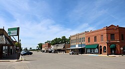
Main Street in Ordway (2017)
Crowley County Colorado Incorporated and Unincorporated areas Ordway Highlighted 0856145.svg
Location within Crowley County and Colorado
Coordinates: 38°13′11″N103°45′26″W / 38.21972°N 103.75722°W / 38.21972; -103.75722 [1]
Country United States
State Colorado
County Crowley [2]
Incorporated September 4, 1900 [3]
Area
[4]
  Total
0.77 sq mi (2.00 km2)
  Land0.77 sq mi (2.00 km2)
  Water0.00 sq mi (0.00 km2)
Elevation
[1]
4,311 ft (1,314 m)
Population
 (2020) [5]
  Total
1,066
  Density1,400/sq mi (530/km2)
Time zone UTC−7 (MST)
  Summer (DST) UTC−6 (MDT)
ZIP Code
81063 [6]
Area code 719
FIPS code 08-56145 [1]
GNIS ID 203804 [1]
Website Town of Ordway

Ordway is a statutory town in and the county seat of Crowley County, Colorado, United States, that is also the most populous community in the county. [1] The population was 1,066 at the 2020 census. [5]

Contents

History

A post office called Ordway has been in operation since 1890. [7] The community was named after George N. Ordway, a Denver politician. [8]

Geography

Ordway is located in south-central Crowley County at 38°13′11″N103°45′26″W / 38.21972°N 103.75722°W / 38.21972; -103.75722 (38.219633, -103.757264). [9] State Highway 96 runs along the southern edge of the town, leading west 49 miles (79 km) to Pueblo and east 60 miles (97 km) to Eads. Highway 71 runs along the eastern edge of the town and leads south 11 miles (18 km) to U.S. Route 50 near Rocky Ford and north 75 miles (121 km) to Interstate 70 at Limon.

According to the United States Census Bureau, Ordway has a total area of 0.8 square miles (2.1 km2), all of it land.

Climate

According to the Köppen Climate Classification system, Ordway has a cold semi-arid climate, abbreviated "BSk" on climate maps. The hottest temperature recorded in Ordway was 111 °F (43.9 °C) on July 14, 2003 and July 20, 2005, while the coldest temperature recorded was −29 °F (−33.9 °C) on February 15, 2021. [10]

Climate data for Ordway, Colorado, 1991–2020 normals, extremes 1980–present
MonthJanFebMarAprMayJunJulAugSepOctNovDecYear
Record high °F (°C)77
(25)
81
(27)
88
(31)
95
(35)
107
(42)
110
(43)
111
(44)
108
(42)
105
(41)
98
(37)
85
(29)
80
(27)
111
(44)
Mean maximum °F (°C)68.5
(20.3)
71.0
(21.7)
80.7
(27.1)
87.4
(30.8)
95.7
(35.4)
103.5
(39.7)
105.4
(40.8)
102.7
(39.3)
98.9
(37.2)
90.0
(32.2)
77.3
(25.2)
67.7
(19.8)
106.5
(41.4)
Mean daily maximum °F (°C)44.8
(7.1)
48.3
(9.1)
59.6
(15.3)
67.1
(19.5)
77.1
(25.1)
88.9
(31.6)
94.2
(34.6)
91.1
(32.8)
83.3
(28.5)
69.6
(20.9)
55.9
(13.3)
45.1
(7.3)
68.7
(20.4)
Daily mean °F (°C)28.6
(−1.9)
32.4
(0.2)
42.4
(5.8)
50.3
(10.2)
61.0
(16.1)
72.0
(22.2)
77.5
(25.3)
75.1
(23.9)
66.0
(18.9)
52.0
(11.1)
38.8
(3.8)
29.1
(−1.6)
52.1
(11.2)
Mean daily minimum °F (°C)12.3
(−10.9)
16.6
(−8.6)
25.2
(−3.8)
33.5
(0.8)
45.0
(7.2)
55.1
(12.8)
60.7
(15.9)
59.0
(15.0)
48.7
(9.3)
34.3
(1.3)
21.8
(−5.7)
13.0
(−10.6)
35.4
(1.9)
Mean minimum °F (°C)−3.6
(−19.8)
−1.8
(−18.8)
9.7
(−12.4)
19.3
(−7.1)
30.4
(−0.9)
44.0
(6.7)
53.0
(11.7)
50.9
(10.5)
35.7
(2.1)
17.3
(−8.2)
5.1
(−14.9)
−4.5
(−20.3)
−10.3
(−23.5)
Record low °F (°C)−24
(−31)
−29
(−34)
−3
(−19)
5
(−15)
20
(−7)
32
(0)
44
(7)
34
(1)
20
(−7)
−12
(−24)
−15
(−26)
−23
(−31)
−29
(−34)
Average precipitation inches (mm)0.24
(6.1)
0.21
(5.3)
0.50
(13)
1.12
(28)
1.51
(38)
1.52
(39)
2.18
(55)
1.92
(49)
0.70
(18)
0.78
(20)
0.31
(7.9)
0.24
(6.1)
11.23
(285.4)
Average snowfall inches (cm)2.4
(6.1)
3.0
(7.6)
2.7
(6.9)
0.8
(2.0)
0.0
(0.0)
0.0
(0.0)
0.0
(0.0)
0.0
(0.0)
0.1
(0.25)
0.7
(1.8)
1.1
(2.8)
3.3
(8.4)
14.1
(35.85)
Average precipitation days (≥ 0.01 in)1.41.73.03.74.24.55.15.12.72.41.61.637.0
Average snowy days (≥ 0.1 in)1.21.10.80.30.00.00.00.00.00.20.71.25.5
Source 1: NOAA [11]
Source 2: National Weather Service [10]

Demographics

Historical population
CensusPop.Note
1900 138
1910 705410.9%
1920 1,18668.2%
1930 1,139−4.0%
1940 1,1501.0%
1950 1,29012.2%
1960 1,254−2.8%
1970 1,017−18.9%
1980 1,13511.6%
1990 1,025−9.7%
2000 1,24821.8%
2010 1,080−13.5%
2020 1,066−1.3%
U.S. Decennial Census

Notable people

See also

Related Research Articles

<span class="mw-page-title-main">Crowley County, Colorado</span> County in Colorado, United States

Crowley County is a county in Colorado. As of the 2020 census, the population was 5,922. The county seat is Ordway.

<span class="mw-page-title-main">Northglenn, Colorado</span> City in Colorado, United States

The City of Northglenn is a home rule municipality located in Adams and Weld counties, Colorado, United States. Northglenn is a part of the Denver–Aurora–Lakewood, CO Metropolitan Statistical Area. As of the 2020 census the city's population was 38,131. It was built as a master planned community in 1959 by Jordon Perlmutter.

<span class="mw-page-title-main">Walsh, Colorado</span> Town in Colorado, United States

Walsh is a statutory town in Baca County, Colorado, United States. The population was 543 at the 2020 census.

<span class="mw-page-title-main">Crowley, Colorado</span> Town in Crowley County, Colorado, United States

Crowley is a statutory town in Crowley County, Colorado, United States. The town population was 166 at the 2020 United States Census.

<span class="mw-page-title-main">Olney Springs, Colorado</span> Town in Crowley County, Colorado, United States

Olney Springs is a statutory town in Crowley County, Colorado, United States. The population was 315 at the 2020 census.

<span class="mw-page-title-main">Sugar City, Colorado</span> Town in Colorado, United States

Sugar City is a statutory town in Crowley County, Colorado, United States. The population was 259 at the 2020 census.

<span class="mw-page-title-main">Silt, Colorado</span> Town in Colorado, United States

Silt is a statutory town in Garfield County, Colorado, United States. The population was 3,536 at the 2020 census, up from 2,930 at the 2010 census. The town is part of the Glenwood Springs Micropolitan Area.

<span class="mw-page-title-main">Walden, Colorado</span> Town in Jackson County, Colorado, United States

Walden is the Statutory Town that is the county seat, the most populous community, and the only incorporated municipality in Jackson County, Colorado, United States. It is situated in the center of a large open valley called North Park. People from Walden and the surrounding area refer to themselves as "North Parkers". The town population was 606 at the 2020 census. The town sits at an elevation of 8,099 feet. It was established in 1889 and was incorporated December 2, 1890. Mark A. Walden, an early postmaster, gave the community his name.

<span class="mw-page-title-main">Haswell, Colorado</span> Town in Colorado, United States

Haswell is a statutory town located in Kiowa County, Colorado, United States. The town population was 71 at the 2020 United States Census.

<span class="mw-page-title-main">Kim, Colorado</span> Town in Colorado, United States

Kim is a Statutory Town in Las Animas County, Colorado, United States. The population was 63 at the time of the 2020 United States Census.

<span class="mw-page-title-main">Merino, Colorado</span> Town in Colorado, United States

The Town of Merino is a Statutory Town in Logan County, Colorado, United States. The town population was 281 at the 2020 United States Census.

<span class="mw-page-title-main">Sterling, Colorado</span> City in Colorado, United States

Sterling is a home rule municipality and the county seat and most populous municipality of Logan County, Colorado, United States. Sterling is the principal city of the Sterling, CO Micropolitan Statistical Area. The city population was 13,735 at the 2020 census.

<span class="mw-page-title-main">Craig, Colorado</span> City in Moffat County, Colorado, U.S.

Craig is a home rule municipality that is the county seat and the most populous municipality of Moffat County, Colorado, United States. The city population was 9,060 at the 2020 United States census. Craig is the principal city of the Craig, CO Micropolitan Statistical Area.

<span class="mw-page-title-main">Wiggins, Colorado</span> Town in Colorado, United States

Wiggins is a statutory town in Morgan County, Colorado, United States. The population was 1,401 as of the 2020 census, up from 893 at the 2010 census.

<span class="mw-page-title-main">Manzanola, Colorado</span> Town in Otero County, Colorado, United States

Manzanola is a Statutory Town in Otero County, Colorado, United States. The town population was 341 at the 2020 United States Census.

<span class="mw-page-title-main">Rye, Colorado</span> Town in Colorado, United States

Rye is a Statutory Town in Pueblo County, Colorado, United States. The population was 206 at the 2020 census.

<span class="mw-page-title-main">Ophir, Colorado</span> Town in San Migel County, Colorado, United States

Ophir is a home rule municipality town governed by a general assembly and is located in San Miguel County, Colorado, United States. It is located two miles from the Ames Hydroelectric Generating Plant, the world's first hydroelectric plant to supply alternating current electricity for an industrial purpose (mining). The population was 197 at the 2020 census.

<span class="mw-page-title-main">Otis, Colorado</span> Town in Colorado, United States

Otis is a Statutory Town in Washington County, Colorado, United States. The population was 511 at the 2020 census.

<span class="mw-page-title-main">Raymer, Colorado</span> Town in Colorado, United States

The Town of Raymer is a Statutory Town located in Weld County, Colorado, United States. The population was 110 at the U.S. Census 2020.

<span class="mw-page-title-main">Orchard, Colorado</span> Unincorporated community in Colorado, United States

Orchard is an unincorporated town, a post office, and a census-designated place (CDP) located in and governed by Morgan County, Colorado, United States. The CDP is a part of the Fort Morgan, CO Micropolitan Statistical Area. The Orchard post office has the ZIP Code 80649. As of the 2020 census, the population of the Orchard CDP was 76.

References

  1. 1 2 3 4 5 "Ordway, Colorado", Geographic Names Information System , United States Geological Survey, United States Department of the Interior
  2. "Active Colorado Municipalities". State of Colorado, Department of Local Affairs. Archived from the original on December 12, 2009. Retrieved September 1, 2007.
  3. "Colorado Municipal Incorporations". State of Colorado, Department of Personnel & Administration, Colorado State Archives. December 1, 2004. Retrieved September 2, 2007.
  4. "2019 U.S. Gazetteer Files". United States Census Bureau. Retrieved July 1, 2020.
  5. 1 2 United States Census Bureau. "Ordway town; Colorado" . Retrieved April 25, 2023.
  6. "ZIP Code Lookup". United States Postal Service. Archived from the original (JavaScript/HTML) on November 4, 2010. Retrieved November 28, 2007.
  7. "Post offices". Jim Forte Postal History. Retrieved July 6, 2016.
  8. Dawson, John Frank. Place names in Colorado: why 700 communities were so named, 150 of Spanish or Indian origin. Denver, CO: The J. Frank Dawson Publishing Co. p. 38.
  9. "US Gazetteer files: 2010, 2000, and 1990". United States Census Bureau. February 12, 2011. Retrieved April 23, 2011.
  10. 1 2 "NOAA Online Weather Data – NWS". National Weather Service. Retrieved January 26, 2025.
  11. "U.S. Climate Normals Quick Access – Station: Ordway 1 ENE, CO". National Oceanic and Atmospheric Administration. Retrieved January 26, 2025.