Conejos, Colorado

Last updated
Conejos, Colorado
Conejos County Courthouse.JPG
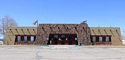
Conejos County Courthouse in Conejos.
Conejos County Colorado Incorporated and Unincorporated areas Conejos Highlighted 0816715.svg
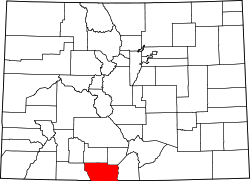
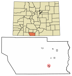
Location of the Conejos CDP in Conejos County, Colorado.
Usa edcp location map.svg
Red pog.svg
Conejos
Location of Conejos, Colorado.
USA Colorado location map.svg
Red pog.svg
Conejos
Conejos (Colorado)
Coordinates: 37°05′18″N106°01′11″W / 37.0883°N 106.0197°W / 37.0883; -106.0197 (Conejos, Colorado) [1]
Country United States
State Colorado
County Conejos [2]
Founded1858
Government
  Type unincorporated community
  Body Conejos County [2]
Area
[3]
  Total
0.484 sq mi (1.254 km2)
  Land0.484 sq mi (1.254 km2)
  Water0.000 sq mi (0.000 km2)
Elevation
[1]
7,904 ft (2,409 m)
Population
 (2020) [4]
  Total
46
  Density95/sq mi (37/km2)
Time zone UTC−07:00 (MST)
  Summer (DST) UTC−06:00 (MDT)
ZIP code [5]
81129
Area code 719
GNIS place ID 190913
GNIS town ID 2631317
FIPS code 08-16715

Conejos (Spanish for "rabbits") is an unincorporated town, a post office, a census-designated place (CDP), and the county seat of Conejos County, Colorado, United States. The Conejos post office has the ZIP Code 81129. [5] At the United States Census 2020, the population of the Conejos CDP was 46. [4] Conejos is the last unincorporated county seat in the State of Colorado.

Contents

History

Our Lady of Guadalupe Catholic Church in Conejos. Our Lady of Guadalupe Catholic Church - Conejos, Colorado, 2016.jpg
Our Lady of Guadalupe Catholic Church in Conejos.

Conejos was settled in 1858 in what was then Taos County, New Mexico Territory. [6] A major historical and architectural feature of Conejos is the Our Lady of Guadalupe Catholic Church, founded in 1858. [6] The church was the first Roman Catholic parish in modern-day Colorado and was constructed by Spanish colonists from Taos, New Mexico. [7]

The Territory of Colorado was organized on February 28, 1861. [8] On November 1, 1861, the Territorial Legislature created Guadaloupe County with the village of Guadalupe as the county seat. [9] Six days later, the legislature changed the county name to Conejos County. [10] [11] Fearing flooding, the Conejos, Colorado Territory, post office opened on February 25, 1862, at a sight 3 feet (1 m) higher across the Conejos River. [12] In 1863, Conejos County moved its county seat 0.6 miles (1.0 km) across the Conejos River to town of Conejos.

Geography

Conejos is located in southeastern Conejos County in the San Luis Valley. It is bordered to the south by the town of Antonito. U.S. Route 285 forms the eastern edge of the community and leads north 28 miles (45 km) to Alamosa, Colorado, and south 31 miles (50 km) to Tres Piedras, New Mexico.

At the 2020 United States Census, the Conejos CDP had an area of 310 acres (1.254 km2), all land. [3]

Demographics

The United States Census Bureau initially defined the Conejos CDP for the United States Census 2010.

Conejos CDP, Colorado
YearPop.±%
2010 58    
2020 46−20.7%
Source: United States Census Bureau

See also

References

  1. 1 2 "Conejos, Colorado". Geographic Names Information System . United States Geological Survey, United States Department of the Interior . Retrieved July 26, 2025.
  2. 1 2 "Colorado Counties". Colorado Department of Local Affairs . Retrieved July 26, 2025.
  3. 1 2 "State of Colorado Census Designated Places - BAS20 - Data as of January 1, 2020". United States Census Bureau . Retrieved December 21, 2020.
  4. 1 2 United States Census Bureau. "Conejos CDP, Colorado" . Retrieved April 2, 2023.
  5. 1 2 "ZIP Code Lookup". United States Postal Service . Retrieved July 26, 2025.
  6. 1 2 "History". ologp.com. Conejos, Colorado: Our Lady of Guadalupe Parish. Retrieved 24 November 2020.
  7. Howlett, William (1908). "Denver". The Catholic Encyclopedia. NewAdvent.org. Retrieved 5 January 2021.
  8. Thirty-sixth United States Congress (February 28, 1861). "An Act To provide a temporary Government for the Territory of Colorado" (PDF). Library of Congress . Retrieved December 24, 2024.
  9. "Colorado County History". COGenWeb Project. April 29, 2011. Archived from the original on July 23, 2008. Retrieved July 21, 2021.
  10. Stanwyck, Don; Zion, Lee (2003). "Colorado County Evolution". COGenWeb Project. Retrieved October 12, 2024.
  11. Dawson, John Frank. Place names in Colorado: why 700 communities were so named, 150 of Spanish or Indian origin. Denver, CO: The J. Frank Dawson Publishing Co. p. 15.
  12. Bauer, William H.; Ozment, James L.; Willard, John H. (1990). Colorado Post Offices 1859–1989. Golden, Colorado: Colorado Railroad Historical Foundation. ISBN   0-918654-42-4.