San Juan County | |
---|---|
Coordinates: 37°46′N107°40′W / 37.77°N 107.67°W | |
Country | United States |
State | Colorado |
Founded | January 31, 1876 |
Named for | San Juan River |
Seat | Silverton |
Largest town | Silverton |
Area | |
• Total | 388 sq mi (1,000 km2) |
• Land | 387 sq mi (1,000 km2) |
• Water | 0.8 sq mi (2 km2) 0.2% |
Population (2020) | |
• Total | 705 |
• Density | 1.8/sq mi (0.7/km2) |
Time zone | UTC−7 (Mountain) |
• Summer (DST) | UTC−6 (MDT) |
Congressional district | 3rd |
Website | sanjuancounty |
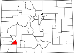
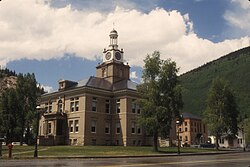
San Juan County is a county located in the U.S. state of Colorado. As of the 2020 census, the population was 705, [1] making it the least populous county in Colorado. The county seat and the only incorporated municipality in the county is Silverton. [2] The county name is the Spanish language name for "Saint John", the name Spanish explorers gave to a river and the mountain range in the area. With a mean elevation of 11,240 feet (3,430 meters), San Juan County is the highest county in the United States and also has the two highest elevation houses in the United States; the ‘Bonnie Belle’ above Animas Forks at 11,900’ – 11,950’ elevation and an unnamed house above Picayune Gulch at 12,000’ elevation.
Long before European settlement, the area was regularly explored by the Anasazi, and later the Utes, who hunted and lived in the San Juans during the summer. [3] There is also speculation that Spanish explorers and fur traders ventured into the area in the 1600s and 1700s. [3]
Permanent settlement in the area surrounding present-day San Juan County began in 1860, near the end of the Colorado Gold Rush. These first settlers were a group of prospectors led by Charles Baker, who made their way into the San Juan Mountains searching for gold. [4]
After the Brunot Agreement with the Utes in 1873, which exchanged four million acres (6,200 sq mi; 16,000 km2) for the Southern Ute Indian Reservation and $25,000 per year, several mining camps were constructed. [5] These would later become the communities of Howardsville, Eureka, and Silverton. San Juan County was formed on January 31, 1876, from part of La Plata County.
The region boomed after George Howard and R. J. McNutt discovered the Sunnyside silver vein along Hurricane Peak, outside the mining camp of Eureka. Gold was then discovered in 1882, which helped the county weather the Panic of 1893 far better than other mining communities, such as Aspen or Creede. [4] The Sunnyside Mine would become one of Colorado's longest running and most productive mines. [6]
Mining operators in the San Juan mountain area of Colorado formed the San Juan District Mining Association (SJDMA) in 1903, as a direct result of a Western Federation of Miners proposal to the Telluride Mining Association for the eight-hour day, which had been approved in a referendum by 72 percent of Colorado voters. [7] The new association consolidated the power of thirty-six mining properties in San Miguel, Ouray, and San Juan Counties. [8] The SJDMA refused to consider any reduction in hours or increase in wages, helping to provoke a bitter strike.
The Sunnyside mine was shut down after the 1929 stock market crash, but was acquired by Standard Metals Corp. in 1959, and reopened, finding gold in 1973 with the Little Mary vein. The county's economy was dealt a devastating blow in 1992 when the mine and the corresponding Shenandoah-Dives mill, the last operating in the region, permanently closed. [9] [6] The closure meant the end of jobs for over one third of the county's workforce. [9]
According to the U.S. Census Bureau, the county has a total area of 388 square miles (1,000 km2), of which 387 square miles (1,000 km2) is land and 0.8 square miles (2.1 km2) (0.2%) is water. [10] It is the fifth-smallest county in Colorado by area. The county is located in the heart of the San Juan Mountains of Colorado. Though it has the highest mean elevation of any county in the United States, at 11,240 feet (3,430 m), none of Colorado's 53 fourteeners (mountains at least 14,000 feet in elevation) are in San Juan County. [11]
Census | Pop. | Note | %± |
---|---|---|---|
1880 | 1,087 | — | |
1890 | 1,572 | 44.6% | |
1900 | 2,342 | 49.0% | |
1910 | 3,063 | 30.8% | |
1920 | 1,700 | −44.5% | |
1930 | 1,935 | 13.8% | |
1940 | 1,439 | −25.6% | |
1950 | 1,471 | 2.2% | |
1960 | 849 | −42.3% | |
1970 | 831 | −2.1% | |
1980 | 833 | 0.2% | |
1990 | 745 | −10.6% | |
2000 | 558 | −25.1% | |
2010 | 699 | 25.3% | |
2020 | 705 | 0.9% | |
2023 (est.) | 802 | [12] | 13.8% |
U.S. Decennial Census [13] 1790–1960 [14] 1900–1990 [15] 1990–2000 [16] 2010–2020 [1] |
As of the census of 2000, there were 558 people, 269 households, and 157 families residing in the county. The population density was one person per square mile (0.39 person/km2). There were 632 housing units at an average density of 2 per square mile (0.77/km2). The racial makeup of the county was 97.13% White, 0.72% Native American, 0.18% Asian, 0.36% Pacific Islander, 0.72% from other races, and 0.90% from two or more races. 7.35% of the population were Hispanic or Latino of any race.
There were 269 households, out of which 23.80% had children under the age of 18 living with them, 43.90% were married couples living together, 8.90% had a female householder with no husband present, and 41.30% were non-families. 36.80% of all households were made up of individuals, and 4.80% had someone living alone who was 65 years of age or older. The average household size was 2.06 and the average family size was 2.63.
In the county, the population was spread out, with 20.10% under the age of 18, 4.30% from 18 to 24, 28.10% from 25 to 44, 40.50% from 45 to 64, and 7.00% who were 65 years of age or older. The median age was 44 years. For every 100 females, there were 110.60 males. For every 100 females age 18 and over, there were 112.40 males.
The median income for a household in the county was $30,764, and the median income for a family was $40,000. Males had a median income of $30,588 versus $19,545 for females. The per capita income for the county was $17,584. About 13.50% of families and 20.90% of the population were below the poverty line, including 29.40% of those under age 18 and 7.10% of those age 65 or over.
San Juan county is the only county outside Alaska where walking is the most common form of commute to work. As of 2013, 33% of residents walked to work, 18% drove alone, 19% carpooled, and 18% bicycled, though the small population size introduces considerable margins of error to these statistics. [17]
As of November 2006, the one and only local school had 53 students in grades K–12.
In the era of William Jennings Bryan, San Juan County strongly favored the Democratic Party: no Republican managed to carry the county between 1892 and 1916, and it was even one of the few northern or western counties to vote for Alton B. Parker in 1904. It remained a Democratic-leaning county until the 1960s but then turned towards the Republican Party in subsequent decades. No Democratic presidential nominee won San Juan County between 1968 and 2000, although it was one of fifteen rural or remote counties to give a plurality to Ross Perot in 1992. Since John Kerry carried the county for his party for the first time in four decades at the 2004 election, San Juan County has voted Democratic at the last five Presidential elections.
Year | Republican | Democratic | Third party | |||
---|---|---|---|---|---|---|
No. | % | No. | % | No. | % | |
2020 | 202 | 35.94% | 342 | 60.85% | 18 | 3.20% |
2016 | 215 | 42.49% | 265 | 52.37% | 26 | 5.14% |
2012 | 212 | 41.90% | 266 | 52.57% | 28 | 5.53% |
2008 | 218 | 43.95% | 264 | 53.23% | 14 | 2.82% |
2004 | 216 | 44.44% | 253 | 52.06% | 17 | 3.50% |
2000 | 210 | 48.17% | 149 | 34.17% | 77 | 17.66% |
1996 | 153 | 41.35% | 133 | 35.95% | 84 | 22.70% |
1992 | 118 | 26.05% | 147 | 32.45% | 188 | 41.50% |
1988 | 210 | 50.36% | 192 | 46.04% | 15 | 3.60% |
1984 | 320 | 61.66% | 183 | 35.26% | 16 | 3.08% |
1980 | 268 | 48.82% | 146 | 26.59% | 135 | 24.59% |
1976 | 221 | 53.77% | 167 | 40.63% | 23 | 5.60% |
1972 | 238 | 58.33% | 140 | 34.31% | 30 | 7.35% |
1968 | 165 | 46.09% | 134 | 37.43% | 59 | 16.48% |
1964 | 129 | 31.70% | 278 | 68.30% | 0 | 0.00% |
1960 | 218 | 45.23% | 261 | 54.15% | 3 | 0.62% |
1956 | 324 | 58.38% | 231 | 41.62% | 0 | 0.00% |
1952 | 432 | 56.77% | 327 | 42.97% | 2 | 0.26% |
1948 | 329 | 47.00% | 348 | 49.71% | 23 | 3.29% |
1944 | 328 | 55.88% | 258 | 43.95% | 1 | 0.17% |
1940 | 452 | 54.20% | 378 | 45.32% | 4 | 0.48% |
1936 | 196 | 23.61% | 622 | 74.94% | 12 | 1.45% |
1932 | 160 | 22.44% | 544 | 76.30% | 9 | 1.26% |
1928 | 277 | 37.13% | 436 | 58.45% | 33 | 4.42% |
1924 | 218 | 39.78% | 206 | 37.59% | 124 | 22.63% |
1920 | 330 | 50.46% | 290 | 44.34% | 34 | 5.20% |
1916 | 214 | 21.62% | 693 | 70.00% | 83 | 8.38% |
1912 | 231 | 22.49% | 555 | 54.04% | 241 | 23.47% |
San Juan County is located in the U.S. state of New Mexico. As of the 2020 census, the population was 121,661 making it the fifth-most populous county in New Mexico. Its county seat is Aztec. The county was created in 1887.
Colfax County is a county in the U.S. state of New Mexico. As of the 2020 census, the population was 12,387. Its county seat is Raton. It is south from the Colorado state line. This county was named for Schuyler Colfax (1823–1885), seventeenth Vice President of the United States under U.S. President Ulysses S. Grant.
San Miguel County is a county located in the U.S. state of Colorado. As of the 2020 census, the population was 8,072. The county seat is Telluride. The county is named for the San Miguel River.
Rio Grande County is a county located in the U.S. state of Colorado. As of the 2020 census, the population was 11,539. The county seat is Del Norte. The county is named for the Rio Grande, which flows through the county.
Ouray County is a county located in the U.S. state of Colorado. As of the 2020 census, the population was 4,874. The county seat is Ouray. Because of its rugged mountain topography, Ouray County is also known as the "Switzerland of America".
Montrose County is a county located in the U.S. state of Colorado. As of the 2020 census, the population was 42,679. The county seat is Montrose, for which the county is named.
Montezuma County is a county located in the southwest corner of the U.S. state of Colorado. As of the 2020 census, the population was 25,849. The county seat is Cortez.
Moffat County is a county located in the U.S. state of Colorado. As of the 2020 census, the population was 13,292. The county seat is Craig. With an area of 4,751 square miles, it is the second-largest county by area in Colorado, behind Las Animas County.
Mineral County is a county located in the U.S. state of Colorado. As of the 2020 census, the population was 865, making it the third-least populous county in Colorado, behind San Juan County and Hinsdale County. The county seat and only incorporated municipality in the county is Creede. The county was named for the many valuable minerals found in the mountains and streams of the area.
La Plata County is a county located in the U.S. state of Colorado. As of the 2020 census, the population was 55,638. The county seat is Durango. The county was named for the La Plata River and the La Plata Mountains. "La plata" means "the silver" in Spanish.
Jackson County is a county located in the U.S. state of Colorado. As of the 2020 census, the population was 1,379, and it was the fourth least populated in the state. The county is named after the United States President Andrew Jackson. The county seat and only municipality in the county is Walden.
Dolores County is a county located in the U.S. state of Colorado. As of the 2020 census, the population was 2,326. The county seat is Dove Creek.
Costilla County is a county located in the U.S. state of Colorado. As of the 2020 census, the population was 3,499. The county seat is San Luis, the oldest continuously occupied town in Colorado.
Durango is a home rule municipality that is the county seat and the most populous municipality of La Plata County, Colorado, United States. The city population was 19,071 at the 2020 United States Census. Durango is the home of Fort Lewis College.
Cortez is a home rule municipality that is the county seat and the most populous municipality of Montezuma County, Colorado, United States. The city population was 8,766 at the 2020 United States Census.
Mancos is a statutory town in Montezuma County, Colorado, United States. The population was 1,196 at the 2020 census, down from 1,336 in 2010.
Ouray is a home rule municipality that is the county seat of Ouray County, Colorado, United States. The city population was 898 as of the 2020 census. The Ouray Post Office has the ZIP Code 81427. Located at an elevation of 7,792 feet (2,375 m), Ouray's climate, natural alpine environment, and scenery have earned it the nickname "Switzerland of America".
Silverton is a statutory town that is the county seat, the most populous community, and the only incorporated municipality in San Juan County, Colorado, United States. The town is located in a remote part of the western San Juan Mountains, a range of the Rocky Mountains. The first mining claims were made in mountains above the Silverton in 1860, near the end of the Colorado Gold Rush and when the land was still controlled by the Utes. Silverton was established shortly after the Utes ceded the region in the 1873 Brunot Agreement, and the town boomed from silver mining until the Panic of 1893 led to a collapse of the silver market, and boomed again from gold mining until the recession caused by the Panic of 1907. The entire town is included as a federally designated National Historic Landmark District, the Silverton Historic District.
Eureka is a city in Juab County, Utah, United States. It is part of the Provo–Orem metropolitan area. The population was 669 at the 2010 census, down from 766 in 2000.
Eureka is an extinct mining town in San Juan County, Colorado, United States, along the Animas River, between Silverton and Animas Forks. The town derives its name from the Greek interjection Eureka! The Eureka post office operated from August 9, 1875, until April 30, 1942.