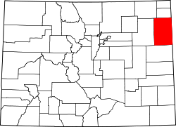
Yuma County | |
---|---|
Coordinates: 40°00′N102°25′W / 40°N 102.42°W | |
Country | United States |
State | Colorado |
Founded | March 15, 1889 |
Seat | Wray |
Largest city | Yuma |
Area | |
• Total | 2,369 sq mi (6,140 km2) |
• Land | 2,364 sq mi (6,120 km2) |
• Water | 4.3 sq mi (11 km2) 0.2% |
Population (2020) | |
• Total | 9,988 |
• Density | 4.2/sq mi (1.6/km2) |
Time zone | UTC−7 (Mountain) |
• Summer (DST) | UTC−6 (MDT) |
Congressional district | 4th |
Website | www |
Yuma County is a county located in the U.S. state of Colorado. As of the 2020 census, the population was 9,988. [1] The county seat is Wray. [2]
According to the U.S. Census Bureau, the county has a total area of 2,369 square miles (6,140 km2), of which 2,364 square miles (6,120 km2) is land and 4.3 square miles (11 km2) (0.2%) is water. [3]
The point where the Arikaree River flows out of Yuma County and into Cheyenne County, Kansas is the lowest point in the State of Colorado at 1,010 meters (3,310 feet) elevation. This crossing point is the highest low point of any U.S. state. [4]
Census | Pop. | Note | %± |
---|---|---|---|
1890 | 2,596 | — | |
1900 | 1,729 | −33.4% | |
1910 | 8,499 | 391.6% | |
1920 | 13,897 | 63.5% | |
1930 | 13,613 | −2.0% | |
1940 | 12,102 | −11.1% | |
1950 | 10,827 | −10.5% | |
1960 | 8,912 | −17.7% | |
1970 | 8,544 | −4.1% | |
1980 | 9,682 | 13.3% | |
1990 | 8,954 | −7.5% | |
2000 | 9,841 | 9.9% | |
2010 | 10,043 | 2.1% | |
2020 | 9,988 | −0.5% | |
2023 (est.) | 9,862 | [5] | −1.3% |
U.S. Decennial Census [6] 1790-1960 [7] 1900-1990 [8] 1990-2000 [9] 2010-2020 [1] |
At the 2000 census there were 9,841 people, 3,800 households, and 2,644 families living in the county. The population density was 4 people per square mile (1.5 people/km2). There were 4,295 housing units at an average density of 2 units per square mile (0.77 units/km2). The racial makeup of the county was 94.17% White, 0.11% Black or African American, 0.28% Native American, 0.07% Asian, 0.02% Pacific Islander, 4.14% from other races, and 1.21% from two or more races. 12.88% of the population were Hispanic or Latino of any race. [10] Of the 3,800 households 33.30% had children under the age of 18 living with them, 59.60% were married couples living together, 6.80% had a female householder with no husband present, and 30.40% were non-families. 27.40% of households were one person and 13.30% were one person aged 65 or older. The average household size was 2.55 and the average family size was 3.13.
The age distribution was 28.30% under the age of 18, 7.10% from 18 to 24, 26.00% from 25 to 44, 22.30% from 45 to 64, and 16.30% 65 or older. The median age was 37 years. For every 100 females there were 96.80 males. For every 100 females age 18 and over, there were 94.90 males.
The median household income was $33,169 and the median family income was $39,814. Males had a median income of $26,124 versus $18,578 for females. The per capita income for the county was $16,005. About 8.80% of families and 12.90% of the population were below the poverty line, including 15.50% of those under age 18 and 10.70% of those age 65 or over.
Like all the High Plains, Yuma County is a Republican Party stronghold in presidential elections. Only nine presidential elections from 1892 to the present day have seen the county fail to back the Republican candidate, the most recent being 1964 during Lyndon B. Johnson's statewide & national landslide.
Year | Republican | Democratic | Third party(ies) | |||
---|---|---|---|---|---|---|
No. | % | No. | % | No. | % | |
2020 | 4,107 | 82.45% | 785 | 15.76% | 89 | 1.79% |
2016 | 3,850 | 80.36% | 726 | 15.15% | 215 | 4.49% |
2012 | 3,490 | 76.25% | 987 | 21.56% | 100 | 2.18% |
2008 | 3,286 | 73.30% | 1,117 | 24.92% | 80 | 1.78% |
2004 | 3,456 | 75.81% | 1,064 | 23.34% | 39 | 0.86% |
2000 | 3,156 | 72.42% | 1,082 | 24.83% | 120 | 2.75% |
1996 | 2,589 | 58.72% | 1,439 | 32.64% | 381 | 8.64% |
1992 | 2,019 | 44.82% | 1,269 | 28.17% | 1,217 | 27.01% |
1988 | 2,513 | 56.93% | 1,835 | 41.57% | 66 | 1.50% |
1984 | 3,394 | 74.32% | 1,121 | 24.55% | 52 | 1.14% |
1980 | 3,220 | 68.89% | 1,043 | 22.31% | 411 | 8.79% |
1976 | 2,350 | 52.20% | 2,025 | 44.98% | 127 | 2.82% |
1972 | 2,873 | 71.03% | 1,066 | 26.35% | 106 | 2.62% |
1968 | 2,529 | 62.68% | 1,175 | 29.12% | 331 | 8.20% |
1964 | 2,007 | 48.12% | 2,145 | 51.43% | 19 | 0.46% |
1960 | 2,806 | 65.18% | 1,489 | 34.59% | 10 | 0.23% |
1956 | 2,782 | 64.26% | 1,544 | 35.67% | 3 | 0.07% |
1952 | 3,404 | 71.92% | 1,292 | 27.30% | 37 | 0.78% |
1948 | 2,277 | 54.05% | 1,907 | 45.26% | 29 | 0.69% |
1944 | 2,847 | 67.45% | 1,374 | 32.55% | 0 | 0.00% |
1940 | 3,531 | 64.11% | 1,917 | 34.80% | 60 | 1.09% |
1936 | 2,462 | 45.26% | 2,878 | 52.90% | 100 | 1.84% |
1932 | 2,129 | 37.34% | 3,220 | 56.48% | 352 | 6.17% |
1928 | 3,401 | 69.07% | 1,383 | 28.09% | 140 | 2.84% |
1924 | 2,789 | 57.91% | 865 | 17.96% | 1,162 | 24.13% |
1920 | 2,673 | 63.42% | 1,254 | 29.75% | 288 | 6.83% |
1916 | 1,436 | 34.51% | 2,466 | 59.26% | 259 | 6.22% |
1912 | 466 | 14.42% | 1,170 | 36.20% | 1,596 | 49.38% |
1908 | 1,061 | 44.67% | 1,148 | 48.34% | 166 | 6.99% |
1904 | 1,110 | 63.50% | 525 | 30.03% | 113 | 6.46% |
1900 | 316 | 42.25% | 392 | 52.41% | 40 | 5.35% |
1896 | 180 | 28.44% | 442 | 69.83% | 11 | 1.74% |
1892 | 198 | 35.29% | 0 | 0.00% | 363 | 64.71% |
Cheyenne County is a county in the U.S. state of Nebraska. As of the 2020 United States Census, the population was 9,468. Its county seat is Sidney. The county was formed in 1871 and named for the Cheyenne Native American tribe. In the Nebraska license plate system, Cheyenne County is represented by the prefix 39 as it had the 39th-largest number of vehicles registered in the county when the license plate system was established in 1922.
Sharkey County is a county located in the U.S. state of Mississippi. Part of the eastern border is formed by the Yazoo River. According to the 2020 census, the population was 3,800, making it the second-least populous county in Mississippi, after Issaquena County. Its county seat is Rolling Fork. The county is named after William L. Sharkey, the provisional Governor of Mississippi in 1865.
Washington County is a county located in the eastern side of the U.S. state of Colorado. As of the 2020 census, the population was 4,817, making it the least populous “Washington County” in the United States. The county seat is Akron. The county was named in honor of the United States President George Washington.
Teller County is a county located in the U.S. state of Colorado. As of the 2020 census, the population was 24,710. The county seat is Cripple Creek, and the most populous city is Woodland Park.
Sedgwick County is a county located in the U.S. state of Colorado. As of the 2020 census, the population was 2,404. The county seat is Julesburg. The county was named for Fort Sedgwick, a military post along the Platte Trail, which was named for General John Sedgwick. It is located at the state border with Nebraska.
Rio Grande County is a county located in the U.S. state of Colorado. As of the 2020 census, the population was 11,539. The county seat is Del Norte. The county is named for the Rio Grande, which flows through the county.
Phillips County is a county located in the U.S. state of Colorado. As of the 2020 census, the population was 4,530. The county seat is Holyoke. The county was named in honor of R.O. Phillips, a secretary of the Lincoln Land Company, who organized several towns in Colorado.
Otero County is a county located in the U.S. state of Colorado. As of the 2020 census, the population was 18,690. The county seat is La Junta. The county was named for Miguel Antonio Otero, one of the founders of the town of La Junta and a member of a prominent Hispanic family.
Morgan County is a county located in the U.S. state of Colorado. As of the 2020 census, the population was 29,111. The county seat is Fort Morgan. The county was named after old Fort Morgan, which in turn was named in honor of Colonel Christopher A. Morgan.
Montrose County is a county located in the U.S. state of Colorado. As of the 2020 census, the population was 42,679. The county seat is Montrose, for which the county is named.
Logan County is a county located in the U.S. state of Colorado. As of the 2020 census, the population was 21,528. The county seat is Sterling. The county was named for General John A. Logan. Logan County comprises the Sterling, CO Micropolitan Statistical Area.
Lincoln County is a county located in the U.S. state of Colorado. As of the 2020 census, the population was 5,675. The county seat is Hugo. The county obtains its name in memory of the United States President Abraham Lincoln. County was formed from portions of Bent and Elbert counties in 1889 from a restructuring of Colorado counties.
Las Animas County is a county located in the U.S. state of Colorado. As of the 2020 census, the population was 14,555. The county seat is Trinidad. The county takes its name from the Mexican Spanish name of the Purgatoire River, originally called El Río de las Ánimas Perdidas en el Purgatorio, which means "River of the Lost Souls in Purgatory."
Kit Carson County is a county located in the U.S. state of Colorado. As of the 2020 census, the population was 7,087. The county seat is Burlington. The county was established in 1889 and named for American frontiersman and Indian fighter Kit Carson.
Jackson County is a county located in the U.S. state of Colorado. As of the 2020 census, the population was 1,379, and it was the fourth least populated in the state. The county is named after the United States President Andrew Jackson. The county seat and only municipality in the county is Walden.
Huerfano County is a county located in the U.S. state of Colorado. As of the 2020 census, the population was 6,820. The county seat is Walsenburg. The county, whose name comes from the Spanish huérfano meaning "orphan", was named for the Huerfano Butte, a local landmark. The area of Huerfano County boomed early in the 1900s with the discovery of large coal deposits. After large scale World War II coal demand ended in the 1940s Walsenburg and Huerfano saw a steady economic decline through 2015.
Gilpin County is a county located in the U.S. state of Colorado, smallest in land area behind only the City and County of Broomfield. As of the 2020 census, the population was 5,808. The county seat is Central City. The county was formed in 1861, while Colorado was still a territory, and was named after Colonel William Gilpin, the first territorial governor.
Elbert County is a county located in the U.S. state of Colorado. As of the 2020 census, the population was 26,062. The county seat is Kiowa and the largest town is Elizabeth. Elbert County is included in the Denver-Aurora-Lakewood, CO Metropolitan Statistical Area.
Chaffee County is a county located in the U.S. state of Colorado. As of the 2020 census, the population was 19,476. The county seat is Salida.
Bent County is a county located in the U.S. state of Colorado. As of the 2020 census, the population was 5,650. The county seat and only incorporated municipality is Las Animas. The county is named in honor of frontier trader William Bent.