Derby is an unincorporated community and a census-designated place (CDP) located in and governed by Adams County, Colorado, United States. The CDP is a part of the Denver–Aurora–Lakewood, CO Metropolitan Statistical Area. The population of the Derby CDP was 8,407 at the United States Census 2020. The Commerce City post office serves the area.

Strasburg is an unincorporated town located east of downtown Denver along the I-70 corridor. It is home to Strasburg School District 31-J, and there are several small businesses, medical clinics, and a post office. Strasburg is a census-designated place (CDP) located in and governed by Adams and Arapahoe counties, Colorado, United States. The CDP is a part of the Denver–Aurora–Lakewood, CO Metropolitan Statistical Area. The Strasburg post office has the ZIP Code 80136. At the United States Census 2020, the population of the Strasburg CDP was 3,307.

The Town of Hooper is a Statutory Town located in the San Luis Valley in Alamosa County, Colorado, United States. The population was 81 at the 2020 census.

Battlement Mesa is a census-designated place (CDP) and post office in and governed by Garfield County, Colorado, United States. The CDP is a part of the Glenwood Springs, CO Micropolitan Statistical Area. The Battlement Mesa post office has the ZIP Codes 81635 and 81636. At the United States Census 2020, the population of the Battlement Mesa CDP was 5,438. The Battlement Mesa Metropolitan District provides services.

Shawnee is an unincorporated community and post office in northern Park County, Colorado, United States, that is a historic district listed on the National Register of Historic Places (NRHP).

Watkins is an unincorporated town and a census-designated place (CDP) located in and governed by Arapahoe and Adams counties, Colorado, United States. The CDP is a part of the Denver–Aurora–Lakewood, CO Metropolitan Statistical Area. The town is surrounded by Aurora and its post office, which lies within the Aurora city limits, has the ZIP Code 80137. At the United States Census 2020, the population of the Watkins CDP was 682.
Carr is an unincorporated community that used to have a U.S. Post Office in Weld County, Colorado, United States. The ZIP Code of Carr is 80612. Some consider Carr a ghost town. Today, a few old houses remain plus a church and the schoolhouse, but the old store fronts are gone. There are some scattered old foundations throughout the town. There are a growing number of year-round residents, so the town no longer appears abandoned.

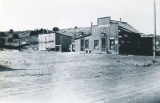
Caddoa is an extinct town located in Bent County, Colorado, United States. The community takes its name from nearby Caddoa Creek.
Eureka is an extinct mining town in San Juan County, Colorado, United States, along the Animas River, between Silverton and Animas Forks. The town derives its name from the Greek interjection Eureka! The Eureka post office operated from August 9, 1875, until April 30, 1942.

Alice is an unincorporated community located in Clear Creek County, Colorado, United States.

Buckskin Joe is an extinct gold mining town located in Park County, Colorado, United States. The town was founded in 1860 as Laurette in what was then the Kansas Territory. The Territory of Colorado was created on February 28, 1861, and the Laurette post office opened on November 14, 1861. Laurette was elected the Park County seat on January 7, 1862. The post office name was changed to Buckskin on December 21, 1865, although the town was popularly known as Buckskin Joe. The county seat was moved to Fair Play in 1867, and the Buckskin post office closed on January 24, 1873.
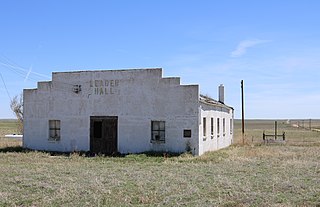
Leader is a populated place in Adams County, Colorado, in the United States. Leader was once the site of a post office, school, and the Leader Community Hall.

Goldfield is an unincorporated community and a census-designated place (CDP) located in and governed by Teller County, Colorado, United States. The CDP is a part of the Colorado Springs, CO Metropolitan Statistical Area. The population of the Goldfield CDP was 63 at the United States Census 2020. The Cripple Creek post office (Zip Code 80813) serves the area.
Bloom is an extinct town located in Otero County, Colorado, United States. The townsite is located at 37.6875°N 103.9566°W at an elevation of 4,800 feet (1,463 m).
Buckingham is an extinct town located in Weld County, Colorado, United States. The townsite is located at 40.6214°N 103.9777°W at an elevation of 4,944 feet (1,507 m).

Holy Cross City is an extinct town located in Eagle County, Colorado, United States. Holy Cross City got its name from Mount of the Holy Cross, located nearby. The Holy Cross post office operated from January 23, 1882, until February 8, 1899, and from December 7, 1904, until August 7, 1905. Presently, the former townsite is located along Holy Cross City Trail within Holy Cross Wilderness, part of White River National Forest. The Mount of the Holy Cross is not visible from the townsite.

Jenne Magafan (1916-1952) was an American painter and muralist. During her short-lived career, she became a successful mural painter in the 1930s and early 1940s. She gained national prominence for her work in the New Deal art program. Her twin sister Ethel Magafan was also a muralist.
Edler is an unincorporated community in Baca County, Colorado, United States.