Idalia, Colorado

Last updated

Idalia, Colorado
Idalia, Colorado.JPG
Idalia, looking east on U.S. Route 36.
Nickname: 
Jewel of the Plains
Yuma County Colorado Incorporated and Unincorporated areas Idalia Highlighted 0838425.svg
Location of the Idalia CDP in Yuma County, Colorado.
Usa edcp location map.svg
Red pog.svg
Idalia
Location of the Idalia CDP in the United States.
Coordinates: 39°42′11″N102°17′38″W / 39.7029168°N 102.2938271°W / 39.7029168; -102.2938271 (Idalia CDP, Colorado) [1]
Country Flag of the United States.svg  United States
State Flag of Colorado.svg  Colorado
County Yuma County
Founded1887
Government
[2]
  Type unincorporated town
Area
[1]
  Total0.085 sq mi (0.220 km2)
  Land0.085 sq mi (0.220 km2)
  Water0.000 sq mi (0.000 km2)
Elevation
[2]
3,966 ft (1,209 m)
Population
 (2020) [3]
  Total97
  Density1,100/sq mi (440/km2)
Time zone UTC-7 (MST)
  Summer (DST) UTC-6 (MDT)
ZIP code [4]
80735
Area code 970
GNIS feature [2] Idalia

Idalia is an unincorporated town, a post office, and a census-designated place (CDP) located in Yuma County, Colorado, United States. The Idalia post office has the ZIP Code 80735. [4] At the United States Census 2020, the population of the Idalia CDP was 97.

Contents

History

Idalia was founded in 1887. [5] 
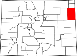
Located on the Eastern Plains of Colorado in southern Yuma County, approximately 150 miles east of Denver and 15 miles from the Kansas border, Idalia has been home for many generations of families. The primary industries of the area are farming, ranching, and natural gas production. The community has many amenities for a small rural community, including the Idalia Vision Foundation, Inc., two churches, local Co-Op, convenience store, restaurants, and a motel. [5] A new Kindergarten through grade-12 school building opened in the fall of 2013 providing state-of-the-art educational programs & facilities.

The Idalia Post Office has been in operation since 1888. [6] The community derives its name from Edaliah Helmick, a pioneer settler. [7]

Geography

Idalia is located along U.S. Highway 36 approximately two miles west of U.S. Highway 385.

The Idalia CDP has an area of 54 acres (0.220 km2), all land. [1]

Climate

Climate data for Idalia, Colorado (1991–2020 normals, extremes 1941–1946, 1987–2021)
MonthJanFebMarAprMayJunJulAugSepOctNovDecYear
Record high °F (°C)75
(24)
81
(27)
84
(29)
92
(33)
99
(37)
110
(43)
107
(42)
104
(40)
101
(38)
93
(34)
83
(28)
78
(26)
110
(43)
Mean daily maximum °F (°C)42.1
(5.6)
44.1
(6.7)
54.7
(12.6)
62.2
(16.8)
71.6
(22.0)
83.9
(28.8)
89.6
(32.0)
86.9
(30.5)
79.0
(26.1)
65.4
(18.6)
52.3
(11.3)
42.7
(5.9)
64.5
(18.1)
Daily mean °F (°C)29.1
(−1.6)
31.1
(−0.5)
40.3
(4.6)
47.7
(8.7)
57.7
(14.3)
69.1
(20.6)
75.1
(23.9)
72.6
(22.6)
64.2
(17.9)
50.7
(10.4)
38.6
(3.7)
29.8
(−1.2)
50.5
(10.3)
Mean daily minimum °F (°C)16.2
(−8.8)
18.1
(−7.7)
26.0
(−3.3)
33.3
(0.7)
43.9
(6.6)
54.4
(12.4)
60.6
(15.9)
58.2
(14.6)
49.4
(9.7)
36.0
(2.2)
24.9
(−3.9)
16.9
(−8.4)
36.5
(2.5)
Record low °F (°C)−27
(−33)
−24
(−31)
−11
(−24)
6
(−14)
24
(−4)
33
(1)
36
(2)
40
(4)
26
(−3)
0
(−18)
−7
(−22)
−26
(−32)
−27
(−33)
Average precipitation inches (mm)0.47
(12)
0.46
(12)
1.03
(26)
1.83
(46)
2.82
(72)
2.84
(72)
2.96
(75)
3.19
(81)
1.20
(30)
1.38
(35)
0.53
(13)
0.43
(11)
19.14
(486)
Average snowfall inches (cm)4.4
(11)
5.0
(13)
5.1
(13)
3.4
(8.6)
0.2
(0.51)
0.0
(0.0)
0.0
(0.0)
0.0
(0.0)
0.5
(1.3)
3.2
(8.1)
2.9
(7.4)
3.8
(9.7)
28.5
(72)
Average precipitation days (≥ 0.01 in)2.43.03.85.98.17.87.06.33.94.32.92.758.1
Average snowy days (≥ 0.1 in)2.02.52.01.30.20.00.00.00.10.61.72.312.7
Source: NOAA [8] [9]

Demographics

The United States Census Bureau initially defined the Idalia CDP for the United States Census 2010.

Idalia CDP, Colorado
YearPop.±%
2010 88    
2020 97+10.2%
Source: United States Census Bureau

Idalia School

There is one school, Idalia School, which teaches preschool through twelfth grade. The school mascot is the wolf. [10] [11] The town also has a preschool and daycare.

Timeline

Idalia Vision Foundation, Inc.

In 1992, the Idalia community formed the Idalia Vision Foundation, Inc., a 501(c)(4) tax-exempt non-profit organization. [12] The Vision Foundation was instrumental in the construction of the "new" gym built in 1995 and today helps support graduates from the Idalia High School with scholarship awards.

Idalia Days Celebration

Community members headed a project aimed at emulating the summer annual town celebrations of neighboring towns. The event, Idalia Days, takes place each summer if enough interest is provided. During its inaugural celebration, Idalia Days provided activities and events in which the community could partake. Drawing on themes used in previous town celebrations, events include bed races, an old-time baseball game, old man six-man football, a melodrama illustrating the history of the towns relocation, a softball tournament, and a town dance, often featuring live music and food.

Idalia High School sports programs

Due to low enrollment of the high school, Idalia, like hundreds of schools throughout Kansas, Nebraska, Wyoming, Utah, and Texas, plays six-man football, a variation of football involving six players on each side off the ball rather than the traditional eleven. Idalia had a dominant program from the late 1990s into the 2000s, winning eight state titles between 1998 and 2010. [13] In recent years, the football program has struggled in the face of low-enrollment and as rival schools have consolidated sports programs in the wake of their own enrollment and budgetary constraints. [14]

However, as the football program continues to rebuild, the Idalia girls' sports teams have had some very successful years. In 2015, the Idalia girls' volleyball team advanced to the Colorado Class 1A volleyball championship match, ultimately falling to Otis High School in five sets. [15] In addition, the girls' basketball program won consecutive state championships in 2015 and 2016. [16] [17] [18]

See also

Related Research Articles

<span class="mw-page-title-main">Yuma County, Colorado</span> County in Colorado, United States

Yuma County is a county located in the U.S. state of Colorado. As of the 2020 census, the population was 9,988. The county seat is Wray.

<span class="mw-page-title-main">Yuma, Arizona</span> City in Arizona, United States

Yuma is a city in and the county seat of Yuma County, Arizona, United States. The city's population was 95,548 at the 2020 census, up from the 2010 census population of 93,064.

<span class="mw-page-title-main">Niwot, Colorado</span> Census-designated place in Colorado, U.S.

Niwot is an unincorporated town, a post office, and a census-designated place (CDP) located in and governed by Boulder County, Colorado, United States. The CDP is a part of the Boulder, Colorado Metropolitan Statistical Area. The Niwot post office has the ZIP Codes 80503 and 80544. At the United States Census 2020, the population of the Niwot CDP was 4,306.

<span class="mw-page-title-main">Cedaredge, Colorado</span> Town in Colorado, United States

The Town of Cedaredge is a home rule municipality located in Delta County, Colorado, United States. The town population was 2,279 at the 2020 United States Census. Cedaredge sits in the Surface Creek Valley beneath the southern slopes of the Grand Mesa, the largest mesa in the world. Its elevated vantage point affords southern views of the San Juan Mountains, the Black Canyon of the Gunnison National Park, and the communities of Delta, Olathe, and Montrose. Cedaredge is a small, agricultural community which produces beef cattle, elk, apples, peaches, and wine from the region's few basic vineyards.

<span class="mw-page-title-main">Evergreen, Colorado</span> Census Designated Place in Colorado, United States

Evergreen is an unincorporated town, a post office, and a census-designated place (CDP) located in and governed by Jefferson County, Colorado, U.S. The CDP is a part of the Denver–Aurora–Lakewood, CO Metropolitan Statistical Area. The Evergreen post office has the ZIP Codes 80439 and 80437. At the 2020 census, the population of the Evergreen CDP was 9,307. The Evergreen Metropolitan District provides services.

<span class="mw-page-title-main">Wray, Colorado</span> City in Colorado, United States

Wray is the home rule municipality that is the county seat of Yuma County, Colorado, United States. Located in the Colorado Plains, the city is 170 miles east of Denver, 9 miles west of the Nebraska state line, and 25 miles northwest of the Kansas state line. The population was 2,358 at the 2020 United States census.

<span class="mw-page-title-main">Yuma, Colorado</span> City in Colorado, United States

Yuma is a home rule municipality that is the most populous municipality in Yuma County, Colorado, United States. The population was 3,456 at the 2020 census.

<span class="mw-page-title-main">Elmont, New York</span> Hamlet and census-designated place in New York, United States

Elmont is an unincorporated hamlet and census-designated place (CDP) located in northwestern Hempstead in Nassau County, New York, United States, along its border with the borough of Queens in New York City. The population was 35,265 as of the 2020 census.

<span class="mw-page-title-main">Bishop McNamara High School</span> School in Forestville, Maryland, United States

Bishop McNamara High School(BMHS, McNamara, or Mac) is a private, Catholic coed high school in Forestville CDP in unincorporated Prince George's County, Maryland.

<span class="mw-page-title-main">Centaurus High School</span> Public high school in Lafayette, Colorado, United States

Centaurus High School (CHS) is a public secondary school in Lafayette, Colorado, United States, serving students in grades nine through twelve. It is part of the Boulder Valley School District and is a School of Opportunity. It offers International Baccalaureate, Advanced Placement, AVID and engineering programs.

<span class="mw-page-title-main">Dr. Phillips High School</span> American public high school

Dr. Phillips High School is a public high school in Dr. Phillips, Florida, United States, near Orlando.

<span class="mw-page-title-main">Joes, Colorado</span> Census-designated place in Yuma County, Colorado, United States

Joes is a census-designated place (CDP) and post office in and governed by Yuma County, Colorado, United States. The Joes post office has the ZIP Code 80822. At the United States Census 2020, the population of the Joes CDP was 82.

<span class="mw-page-title-main">Kirk, Colorado</span> Unincorporated community in Colorado, United States

Kirk is an unincorporated town, a post office, and a census-designated place (CDP) located in and governed by Yuma County, Colorado, United States. The Kirk post office has the ZIP Code 80824. At the United States Census 2020, the population of the Kirk CDP was 61.

<span class="mw-page-title-main">Vernon, Colorado</span> Unincorporated community in Colorado, United States

Vernon is an unincorporated town, a post office, and the center of a census-designated place (CDP) located in and governed by Yuma County, Colorado, United States. The Vernon post office has the ZIP Code 80755. At the United States Census 2020, the population of the total Vernon CDP was 38; the town's specific population was not recorded.

<span class="mw-page-title-main">Laird, Colorado</span> Unincorporated community in Colorado, United States

Laird is an unincorporated community and a census-designated place (CDP) located in and governed by Yuma County, Colorado, United States. The population of the Laird CDP was 46 at the United States Census 2020. The Wray post office (Zip Code 80758) serves Laird postal addresses. Laird has the lowest elevation of any community in Colorado at 3,402 feet (1,037 m).

<span class="mw-page-title-main">Conifer High School</span> Comprehensive public high school in Conifer, Colorado, United States

Conifer High School is a secondary school in Conifer, an unincorporated town located in the foothills of Jefferson County, southwest of Denver, Colorado, United States. The school is located about 20 minutes southwest of SH 470 and a short distance north of U.S. Highway 285.

<span class="mw-page-title-main">Valor Christian High School</span> Private secondary school in Highlands Ranch, Colorado, United States

Valor Christian High School is a private, Christian high school in Highlands Ranch, Colorado, United States. The school colors are Navy blue, Columbia blue, and white, and the school nickname is The Eagles. Valor has four major focuses: Academics, Arts, Athletics, and Discovery.

Scheck Hillel Community School, known prior to 2012 as the Samuel Scheck Hillel Community Day School, is a private, Jewish, co-ed pK–12 school in Ojus, Florida, with a North Miami Beach address. It is located adjacent to the Michael-Ann Russel Jewish Community Center. It is the largest Jewish Day school in South Florida, and one of the largest in the country. Hillel is both a 2011 and 2020 Blue Ribbon school.

<span class="mw-page-title-main">Fairmont Heights High School</span> Public comprehensive secondary school in Landover, Maryland , United States

Fairmont Heights High School (est.1950) is an American public comprehensive secondary school located in Landover, Maryland, just outside Washington D.C. It is part of the Prince George's County Public Schools system. Two middle schools feed into Fairmont Heights. It is part of the School Board District 3.

The Idalia School is a public school that is located in the small farming and ranching community of Idalia, Colorado, United States. The school serves PK-12 students in one main building.

References

  1. 1 2 3 "State of Colorado Census Designated Places - BAS20 - Data as of January 1, 2020". United States Census Bureau . Retrieved December 27, 2020.
  2. 1 2 3 "U.S. Board on Geographic Names: Domestic Names". United States Geological Survey . Retrieved December 27, 2020.
  3. United States Census Bureau. "Idalia CDP, Colorado" . Retrieved April 11, 2023.
  4. 1 2 "Look Up a ZIP Code". United States Postal Service . Retrieved November 21, 2020.
  5. 1 2 "Idalia in Yuma County Colorado". www.consideryumacounty.com. Retrieved October 2, 2017.
  6. "Post offices". Jim Forte Postal History. Retrieved June 27, 2016.
  7. Dawson, John Frank. Place names in Colorado: why 700 communities were so named, 150 of Spanish or Indian origin. Denver, CO: The J. Frank Dawson Publishing Co. p. 28.
  8. "NOWData - NOAA Online Weather Data". National Oceanic and Atmospheric Administration. Retrieved April 5, 2024.
  9. "Summary of Monthly Normals 1991-2020". National Oceanic and Atmospheric Administration. Retrieved April 5, 2024.
  10. "Idalia RJ-3 School District". www.idaliaco.us. Retrieved October 2, 2017.
  11. Garner, Nick (March 7, 2007). "After finding a Cure, Idalia can feel good about chances". Rocky Mountain News . Retrieved October 9, 2008.
  12. "Idalia Visions Foundation |". www.idaliavisions.com. Retrieved October 2, 2017.
  13. "List of Colorado high school football champions through history". CHSAANow.com. Retrieved October 2, 2017.
  14. Verlee, Megan. "Budget Breakdown: Rural Schools Fear Consolidation". Colorado Public Radio. Retrieved October 2, 2017.
  15. "CHSAA's 1A state volleyball bracket and schedule (2015)". CHSAANow.com. November 9, 2015. Retrieved October 2, 2017.
  16. "Colorado high school girls basketball 1A state bracket (2015)". CHSAANow.com. March 8, 2015. Retrieved October 2, 2017.
  17. "Colorado high school girls basketball 1A state bracket (2016)". CHSAANow.com. March 6, 2016. Retrieved October 2, 2017.
  18. "Defensive pressure lifts Idalia to 1A girls basketball title". CHSAANow.com. March 13, 2016. Retrieved October 2, 2017.