Gilpin County, Colorado

Last updated

Gilpin County
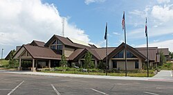
Gilpin Combined Court.JPG
The Gilpin Combined Court, the county courthouse.
Seal of Gilpin County, Colorado.png
Map of Colorado highlighting Gilpin County.svg
Location within the U.S. state of Colorado
Colorado in United States.svg
Colorado's location within the U.S.
Coordinates: 39°52′N105°31′W / 39.86°N 105.52°W / 39.86; -105.52
CountryFlag of the United States.svg United States
StateFlag of Colorado.svg  Colorado
FoundedNovember 1, 1861
Named for William Gilpin
Seat Central City
Largest cityCentral City
Area
  Total150 sq mi (400 km2)
  Land150 sq mi (400 km2)
  Water0.4 sq mi (1 km2)  0.2%
Population
 (2020)
  Total5,808
  Density39/sq mi (15/km2)
Time zone UTC−7 (Mountain)
  Summer (DST) UTC−6 (MDT)
Congressional district 2nd
Website gilpincounty.colorado.gov

Gilpin County is a county located in the U.S. state of Colorado, smallest in land area behind only the City and County of Broomfield. As of the 2020 census, the population was 5,808. [1] The county seat is Central City. [2] The county was formed in 1861, while Colorado was still a territory, and was named after Colonel William Gilpin, [3] the first territorial governor.

Contents

Gilpin County is part of the Denver-Aurora-Lakewood, CO Metropolitan Statistical Area.

Geography

1904 broadside bird's eye view or map of Gilpin County, Colorado, issued by the Gilpin County Chamber of Commerce and the Colorado map publisher George Samuel Clason 1904 Clason Map or View of the Gilpin Colorado Gold and Mineral Belt - Geographicus - GilpinCountyColorado-clason-1904.jpg
1904 broadside bird's eye view or map of Gilpin County, Colorado, issued by the Gilpin County Chamber of Commerce and the Colorado map publisher George Samuel Clason

According to the U.S. Census Bureau, the county has a total area of 150 square miles (390 km2), of which 150 square miles (390 km2) is land and 0.4 square miles (1.0 km2) (0.2%) is water. [4] It is the second-smallest county by area in Colorado.

Adjacent counties

Major highways

National protected areas

State protected area

Scenic trail and byway

Demographics

Historical population
CensusPop.Note
1870 5,490
1880 6,48918.2%
1890 5,867−9.6%
1900 6,69014.0%
1910 4,131−38.3%
1920 1,364−67.0%
1930 1,212−11.1%
1940 1,62534.1%
1950 850−47.7%
1960 685−19.4%
1970 1,27285.7%
1980 2,44191.9%
1990 3,07025.8%
2000 4,75755.0%
2010 5,44114.4%
2020 5,8086.7%
2023 (est.)5,926 [5] 2.0%
U.S. Decennial Census [6]
1790-1960 [7] 1900-1990 [8]
1990-2000 [9] 2010-2020 [1]

At the 2000 census there were 4,757 people, 2,043 households, and 1,264 families in the county. The population density was 32 people per square mile (12 people/km2). There were 2,929 housing units at an average density of 20 units per square mile (7.7 units/km2). The racial makeup of the county was 94.37% White, 0.53% Black or African American, 0.82% Native American, 0.69% Asian, 0.19% Pacific Islander, 1.53% from other races, and 1.87% from two or more races. 4.25% of the population were Hispanic or Latino of any race. [10] Of the 2,043 households 26.90% had children under the age of 18 living with them, 53.00% were married couples living together, 5.70% had a female householder with no husband present, and 38.10% were non-families. 26.80% of households were one person and 3.70% were one person aged 65 or older. The average household size was 2.32 and the average family size was 2.81.

The age distribution was 21.10% under the age of 18, 5.80% from 18 to 24, 37.40% from 25 to 44, 30.00% from 45 to 64, and 5.70% 65 or older. The median age was 38 years. For every 100 females there were 112.70 males. For every 100 females age 18 and over, there were 116.10 males.

The median household income was $51,942 and the median family income was $61,859. Males had a median income of $38,560 versus $30,820 for females. The per capita income for the county was $26,148. About 1.00% of families and 4.00% of the population were below the poverty line, including 1.40% of those under age 18 and 6.10% of those age 65 or over.
United States presidential election results for Gilpin County, Colorado [11]
Year Republican Democratic Third party
No.%No.%No.%
2020 1,83343.79%2,22353.11%1303.11%
2016 1,56643.79%1,63445.69%37610.51%
2012 1,34640.32%1,89256.68%1003.00%
2008 1,28338.08%1,99059.07%962.85%
2004 1,32941.58%1,80756.54%601.88%
2000 1,00640.81%1,09944.58%36014.60%
1996 68238.12%79944.66%30817.22%
1992 46226.26%72641.27%57132.46%
1988 72845.79%80450.57%583.65%
1984 89657.03%63440.36%412.61%
1980 69450.04%44131.80%25218.17%
1976 45141.19%56351.42%817.40%
1972 51657.02%36240.00%272.98%
1968 35852.57%21832.01%10515.42%
1964 23338.83%36360.50%40.67%
1960 31558.55%22341.45%00.00%
1956 39461.66%24438.18%10.16%
1952 35760.41%22838.58%61.02%
1948 30249.43%29648.45%132.13%
1944 27255.85%21343.74%20.41%
1940 41348.65%43150.77%50.59%
1936 32129.81%73668.34%201.86%
1932 27132.46%53964.55%252.99%
1928 29955.17%23643.54%71.29%
1924 36154.78%16124.43%13720.79%
1920 41666.99%18930.43%162.58%
1916 40734.17%76364.06%211.76%
1912 44326.65%93156.02%28817.33%

Communities

The Old Courthouse in Central City houses much of the county government. Old Courthouse, Gilpin County.jpg
The Old Courthouse in Central City houses much of the county government.

Cities

Census-designated places

Other

Historic district

See also

Related Research Articles

<span class="mw-page-title-main">Lyon County, Kentucky</span> County in Kentucky, United States

Lyon County is a county located in the U.S. state of Kentucky. As of the 2020 census, the population was 8,680. Its county seat is Eddyville. The county was formed from Caldwell County, Kentucky in 1854 and named for former Congressman Chittenden Lyon.

<span class="mw-page-title-main">Yuma County, Colorado</span> County in Colorado, United States

Yuma County is a county located in the U.S. state of Colorado. As of the 2020 census, the population was 9,988. The county seat is Wray.

<span class="mw-page-title-main">Teller County, Colorado</span> County in Colorado, United States

Teller County is a county located in the U.S. state of Colorado. As of the 2020 census, the population was 24,710. The county seat is Cripple Creek, and the most populous city is Woodland Park.

<span class="mw-page-title-main">Sedgwick County, Colorado</span> County in Colorado, United States

Sedgwick County is a county located in the U.S. state of Colorado. As of the 2020 census, the population was 2,404. The county seat is Julesburg. The county was named for Fort Sedgwick, a military post along the Platte Trail, which was named for General John Sedgwick. It is located near the state border with Nebraska.

<span class="mw-page-title-main">Saguache County, Colorado</span> County in Colorado, United States

Saguache County is a county located in the U.S. state of Colorado. As of the 2020 census, the population was 6,368. The county seat is Saguache.

<span class="mw-page-title-main">Park County, Colorado</span> County in Colorado, United States

Park County is a county located in the U.S. state of Colorado. As of the 2020 census, the population was 17,390. The county seat is Fairplay. The county was named after the large geographic region known as South Park, which was named by early fur traders and trappers in the area.

<span class="mw-page-title-main">Otero County, Colorado</span> County in Colorado, United States

Otero County is a county located in the U.S. state of Colorado. As of the 2020 census, the population was 18,690. The county seat is La Junta. The county was named for Miguel Antonio Otero, one of the founders of the town of La Junta and a member of a prominent Hispanic family.

<span class="mw-page-title-main">Morgan County, Colorado</span> County in Colorado, United States

Morgan County is a county located in the U.S. state of Colorado. As of the 2020 census, the population was 29,111. The county seat is Fort Morgan. The county was named after old Fort Morgan, which in turn was named in honor of Colonel Christopher A. Morgan.

<span class="mw-page-title-main">Montrose County, Colorado</span> County in Colorado, United States

Montrose County is a county located in the U.S. state of Colorado. As of the 2020 census, the population was 42,679. The county seat is Montrose, for which the county is named.

<span class="mw-page-title-main">Mineral County, Colorado</span> County in Colorado, United States

Mineral County is a county located in the U.S. state of Colorado. As of the 2020 census, the population was 865, making it the third-least populous county in Colorado, behind San Juan County and Hinsdale County. The county seat and only incorporated municipality in the county is Creede. The county was named for the many valuable minerals found in the mountains and streams of the area.

<span class="mw-page-title-main">Logan County, Colorado</span> County in Colorado, United States

Logan County is a county located in the U.S. state of Colorado. As of the 2020 census, the population was 21,528. The county seat is Sterling. The county was named for General John A. Logan.

<span class="mw-page-title-main">Lincoln County, Colorado</span> County in Colorado, United States

Lincoln County is a county located in the U.S. state of Colorado. As of the 2020 census, the population was 5,675. The county seat is Hugo. The county obtains its name in memory of the United States President Abraham Lincoln. County was formed from portions of Bent and Elbert counties in 1889 from a restructuring of Colorado counties.

<span class="mw-page-title-main">Las Animas County, Colorado</span> County in Colorado, United States

Las Animas County is a county located in the U.S. state of Colorado. As of the 2020 census, the population was 14,555. The county seat is Trinidad. The county takes its name from the Mexican Spanish name of the Purgatoire River, originally called El Río de las Ánimas Perdidas en el Purgatorio, which means "River of the Lost Souls in Purgatory."

<span class="mw-page-title-main">Kit Carson County, Colorado</span> County in Colorado, United States

Kit Carson County is a county located in the U.S. state of Colorado. As of the 2020 census, the population was 7,087. The county seat is Burlington. The county was established in 1889 and named for American frontiersman and Indian fighter Kit Carson.

<span class="mw-page-title-main">Grand County, Colorado</span> County in Colorado, United States

Grand County is a county located in the U.S. state of Colorado. As of the 2020 census, the population was 15,717. The county seat is Hot Sulphur Springs.

<span class="mw-page-title-main">Elbert County, Colorado</span> County in the United States

Elbert County is a county located in the U.S. state of Colorado. As of the 2020 census, the population was 26,062. The county seat is Kiowa and the largest town is Elizabeth.

<span class="mw-page-title-main">Clear Creek County, Colorado</span> County in Colorado, United States

Clear Creek County is a county located in the U.S. state of Colorado. As of the 2020 census, the population was 9,397. The county seat is Georgetown.

<span class="mw-page-title-main">Chaffee County, Colorado</span> County in Colorado, United States

Chaffee County is a county located in the U.S. state of Colorado. As of the 2020 census, the population was 19,476. The county seat is Salida.

<span class="mw-page-title-main">Boulder County, Colorado</span> County in Colorado, United States

Boulder County is a county located in the U.S. state of Colorado of the United States. As of the 2020 census, the population was 330,758. The most populous municipality in the county and the county seat is Boulder.

<span class="mw-page-title-main">Bent County, Colorado</span> County in Colorado, United States

Bent County is a county located in the U.S. state of Colorado. As of the 2020 census, the population was 5,650. The county seat and only incorporated municipality is Las Animas. The county is named in honor of frontier trader William Bent.

References

  1. 1 2 "State & County QuickFacts". United States Census Bureau. Retrieved September 5, 2021.
  2. "Find a County". National Association of Counties. Archived from the original on May 31, 2011. Retrieved June 7, 2011.
  3. Gannett, Henry (1905). The Origin of Certain Place Names in the United States. Govt. Print. Off. pp.  138.
  4. "US Gazetteer files: 2010, 2000, and 1990". United States Census Bureau. February 12, 2011. Retrieved April 23, 2011.
  5. "Annual Estimates of the Resident Population for Counties: April 1, 2020 to July 1, 2023". United States Census Bureau. Retrieved March 31, 2024.
  6. "U.S. Decennial Census". United States Census Bureau. Retrieved June 8, 2014.
  7. "Historical Census Browser". University of Virginia Library. Retrieved June 8, 2014.
  8. "Population of Counties by Decennial Census: 1900 to 1990". United States Census Bureau. Retrieved June 8, 2014.
  9. "Census 2000 PHC-T-4. Ranking Tables for Counties: 1990 and 2000" (PDF). United States Census Bureau. Archived (PDF) from the original on March 27, 2010. Retrieved June 8, 2014.
  10. "U.S. Census website". United States Census Bureau . Retrieved May 14, 2011.
  11. Leip, David. "Dave Leip's Atlas of U.S. Presidential Elections". uselectionatlas.org. Retrieved May 26, 2017.

39°52′N105°31′W / 39.86°N 105.52°W / 39.86; -105.52