
The City of Leadville, is the Statutory City that is the county seat and only incorporated municipality in Lake County, Colorado. The city population was 2,602 at the 2010 census and an estimated 2,762 in 2018. Leadville is situated at an elevation of 10,152 feet (3,094 m).

The City of Central, commonly known as Central City, is a Home Rule Municipality in Gilpin and Clear Creek counties, Colorado, United States. Central City is the county seat and the most populous municipality of Gilpin County. The city is a part of the Denver–Aurora–Lakewood, CO Metropolitan Statistical Area. The city population was 663 at the 2010 United States Census. The city is a historic mining settlement founded in 1859 during the Pike's Peak Gold Rush and came to be known as the "Richest Square Mile on Earth". Central City and the adjacent city of Black Hawk form the federally designated Central City/Black Hawk Historic District. The city is now a part of the Denver-Aurora-Lakewood, CO Metropolitan Statistical Area.

Gilpin County is a county located in the U.S. state of Colorado, smallest in land area behind only the City and County of Broomfield. As of the 2010 census, the population was 5,441. The county seat is Central City. The county was formed in 1861, while Colorado was still a Territory, and was named after Colonel William Gilpin, the first territorial governor.
Gold Hill is an unincorporated community and a census-designated place (CDP) located in and governed by Boulder County, Colorado, United States. The CDP is a part of the Boulder, CO Metropolitan Statistical Area. The population of the Gold Hill CDP was 230 at the United States Census 2010. The Boulder post office serves the area.

The City of Black Hawk is a Home Rule Municipality in Gilpin County, Colorado, United States. The city population was 118 at the 2010 United States Census, making Black Hawk the least populous city in Colorado. The tiny city is a historic mining settlement founded in 1859 during the Pike's Peak Gold Rush. Black Hawk is a part of the Denver–Aurora–Lakewood, CO Metropolitan Statistical Area.

The Central City Opera House is located in the Central City/Black Hawk Historic District in Central City, Colorado, United States. It was constructed in 1878. It has offered operatic and theatrical productions that drew prominent actors and performers in the late 19th-century, and in the early 20th-century it was a motion picture theatre.

The Gilpin Railroad, earlier the Gilpin Tramway Company, was a 2 ft narrow gauge railway in Gilpin County, Colorado, in operation from 1887 to 1917.
William Greeneberry "Green" Russell (1818–1877) was an American prospector and miner.

The Georgetown–Silver Plume National Historic Landmark District is a federally designated United States National Historic Landmark that comprises the Town of Georgetown, the Town of Silver Plume, and the Georgetown Loop Historic Mining & Railroad Park between the two silver mining towns along Clear Creek in the Front Range of the Rocky Mountains in Clear Creek County, Colorado, United States.

Gold mining in Colorado, a state of the United States, has been an industry since 1858. It also played a key role in the establishment of the state of Colorado.

Oro City, now a ghost town, was an early Colorado gold placer mining town located near Leadville in the California Gulch. Oro is the Spanish word for gold. Oro City was the site of one the single richest placer gold strikes in Colorado, with estimated gold production of 120,000 to 150,000 troy ounces, worth $2.5 to $3 million at the then-price of $20.67 per troy ounce.

The Jerome Historic District is a National Historic Landmark District encompassing the former mining community of Jerome, Arizona. The town was founded as a mining camp associated with copper deposits that were mined from the late 19th century until 1953. The district was declared a National Historic Landmark in 1966 and was included into the then-new National Register of Historic Places.
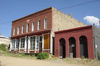
Nevadaville was a gold-mining town in Gilpin County, Colorado, United States. It was also known in the 1860s and 1870s as Nevada City. The post office at Nevadaville was called the Bald Mountain post office, to avoid confusion with other Nevadas and Nevadavilles. The community is now largely a ghost town, although not completely deserted. The Nevadaville Masonic Temple that started in 1861 still holds regular meetings.

The Leadville mining district, located in the Colorado Mineral Belt, was the most productive silver-mining district in the state of Colorado and hosts one of the largest lead-zinc-silver deposits in the world. Oro City, an early Colorado gold placer mining town located about a mile east of Leadville in California Gulch, was the location to one of the richest placer gold strikes in Colorado, with estimated gold production of 120,000–150,000 ozt, worth $2.5 to $3 million at the then-price of $20.67 per troy ounce.
The following is an alphabetical list of articles related to the U.S. state of Colorado.
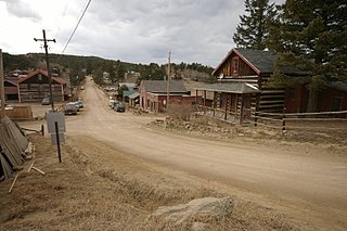
Russell Gulch, Colorado, is a former mining town, now largely a ghost town, in Gilpin County, Colorado, United States. Although the population was once much larger than today, and most of the larger commercial buildings stand empty, the town is not completely deserted.

The Virginia City Historic District is a National Historic Landmark District encompassing Virginia City, Montana, United States. Designated in 1966, the district includes over two hundred nineteenth-century buildings, representing the site of a major gold strike and the capital of Montana for ten years.
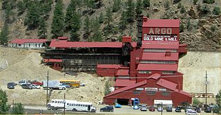
The Argo Gold Mine and Mill is a former gold mining and milling property in Idaho Springs, Colorado, featuring an intact gold mill built at the entrance of the Argo Tunnel. The tunnel was built between 1893 and 1910 to drain the gold mines in Virginia Canyon, Gilpin Gulch, Russell Gulch, Quartz Hill, Nevadaville, and Central City and allow easier ore removal. The success of the tunnel as an access route meant that a large volume of ore began exiting at the Idaho Springs entrance and a large mill was built to process it. At the time it was one of the largest such tunnels and milling operations in the world, directly recovering nearly $100 million in gold and sending another $200 million of high-value ores to smelters in Denver.

Confederate Gulch is a steeply incised gulch or valley on the west-facing slopes of the Big Belt Mountains in the U.S. state of Montana. Its small stream drains westward into Canyon Ferry Lake, on the upper Missouri River near present-day Townsend, Montana. In 1864, Confederate soldiers on parole during the American Civil War made a minor gold discovery in the gulch, but the discovery of the sensationally rich Montana Bar the following year—one of the richest placer strikes per acre ever made—led to other rich gold strikes up and down the gulch, and touched off a frantic boom period of placer gold mining in the area that extended through 1869. From 1866 to 1869, the gulch equaled or outstripped all other mining camps in the Montana Territory in gold production, producing an estimated $19–30 million worth of gold. For a time, Confederate Gulch was the largest community in Montana. In 1866, Montana had a total population of 28,000, and of these, about 10,000 (35%) were working in Confederate Gulch.
The Cripple Creek Gold Rush was a period of gold production in the Cripple Creek area from the late 1800s until the early 1900s. Mining exchanges were in Cripple Creek, Colorado Springs, Pueblo and Victor. Smelting was in Gillett, Florence, and (Old) Colorado City. Mining communities sprang up quickly, but most lasted only as long as gold continued to be produced. Settlements included:


