Delta County, Colorado

Last updated

Delta County
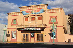
Egyptian Theatre on Main St, Delta, Colorado..JPG
Map of Colorado highlighting Delta County.svg
Location within the U.S. state of Colorado
Colorado in United States.svg
Colorado's location within the U.S.
Coordinates: 38°52′N107°52′W / 38.86°N 107.86°W / 38.86; -107.86
CountryFlag of the United States.svg United States
StateFlag of Colorado.svg  Colorado
FoundedFebruary 11, 1883
Named for City of Delta, Colorado
Seat Delta
Largest cityDelta
Area
  Total1,149 sq mi (2,980 km2)
  Land1,142 sq mi (2,960 km2)
  Water6.5 sq mi (17 km2)  0.6%
Population
 (2020)
  Total31,196
  Estimate 
(2023) [1]
31,746
  Density27/sq mi (10/km2)
Time zone UTC−7 (Mountain)
  Summer (DST) UTC−6 (MDT)
Congressional district 3rd
Website www.deltacounty.com
Hay stack and automobiles of peach pickers, Delta County, 1940. Hay stack and automobile of peach pickers, Delta County, Colorado LCCN2017877613.jpg
Hay stack and automobiles of peach pickers, Delta County, 1940.
Pioneer Town in Cedaredge, 2008 Cedaredgepioneertown.jpg
Pioneer Town in Cedaredge, 2008

Delta County is a county located in the U.S. state of Colorado. As of the 2020 census, the population was 31,196. [2] The county seat is Delta. [3]

Contents

History

Delta County was created by the Colorado legislature on February 11, 1883, out of portions of central Gunnison County. The county was named from a delta of arable land at the mouth of the Uncompahgre River, where it flows into the Gunnison River. [4]

Geography

According to the U.S. Census Bureau, the county has a total area of 1,149 square miles (2,980 km2), of which 1,142 square miles (2,960 km2) is land and 6.5 square miles (17 km2) (0.6%) is water. [5]

Adjacent counties

Major highways

National protected areas

State protected areas

Trails and byways

Demographics

Historical population
CensusPop.Note
1890 2,534
1900 5,487116.5%
1910 13,688149.5%
1920 13,668−0.1%
1930 14,2043.9%
1940 16,47016.0%
1950 17,3655.4%
1960 15,602−10.2%
1970 15,286−2.0%
1980 21,22538.9%
1990 20,980−1.2%
2000 27,83432.7%
2010 30,95211.2%
2020 31,1960.8%
2023 (est.)31,746 [1] 1.8%
U.S. Decennial Census [6]
1790-1960 [7] 1900-1990 [8]
1990-2000 [9] 2010-2020 [2]

At the 2000 census there were 27,834 people, 11,058 households, and 7,939 families living in the county. The population density was 24 people per square mile (9.3 people/km2). There were 12,374 housing units at an average density of 11 units per square mile (4.2 units/km2). The racial makeup of the county was 92.29% White, 0.52% Black or African American, 0.76% Native American, 0.32% Asian, 0.03% Pacific Islander, 4.25% from other races, and 1.83% from two or more races. 11.39% of the population were Hispanic or Latino of any race. [10] Of the 11,058 households 29.00% had children under the age of 18 living with them, 60.30% were married couples living together, 7.90% had a female householder with no husband present, and 28.20% were non-families. 24.80% of households were one person and 12.40% were one person aged 65 or older. The average household size was 2.43 and the average family size was 2.89.

The age distribution was 24.00% under the age of 18, 6.30% from 18 to 24, 23.60% from 25 to 44, 26.50% from 45 to 64, and 19.70% 65 or older. The median age was 42 years. For every 100 females there were 100.80 males. For every 100 females age 18 and over, there were 98.60 males.

The median household income was $32,785 and the median family income was $37,748. Males had a median income of $31,348 versus $19,916 for females. The per capita income for the county was $17,152. About 8.50% of families and 12.10% of the population were below the poverty line, including 15.00% of those under age 18 and 9.60% of those age 65 or over.
Communities

City

Towns

Census Designated Place

Unincorporated communities

Politics

Delta County votes predominantly Republican in national, state, and local elections. No Democratic presidential candidate has reached forty percent of Delta County's vote since Lyndon Johnson carried the county in 1964, and since 1920 Franklin D. Roosevelt in 1932 is the only other Democrat to gain a majority, although Roosevelt did win a plurality against Alf Landon in 1936.

Delta County is split between two house districts for the Colorado House of Representatives, House District 58 & House District 54. [11] Prior to the redistricting, which took effect in the November 2022 election, Delta County was split by House District 54 & 61. [12] The Current Representative for House District 58 is Marc Catlin, who carried the county in the election. [13]

United States presidential election results for Delta County, Colorado [14]
Year Republican Democratic Third party(ies)
No.%No.%No.%
2020 13,08167.53%5,88730.39%4022.08%
2016 11,65569.42%4,08724.34%1,0486.24%
2012 10,91568.54%4,62229.02%3882.44%
2008 10,06765.23%5,08432.94%2831.83%
2004 9,72268.66%4,22429.83%2131.50%
2000 8,37265.99%3,26425.73%1,0508.28%
1996 6,04754.48%3,58432.29%1,46913.23%
1992 4,35941.54%3,42432.63%2,71125.83%
1988 5,44959.59%3,52138.51%1741.90%
1984 6,67869.28%2,83529.41%1261.31%
1980 6,17966.97%2,34825.45%7007.59%
1976 4,98058.82%3,23238.17%2553.01%
1972 4,89067.73%1,90326.36%4275.91%
1968 3,69255.50%2,32734.98%6339.52%
1964 2,88342.24%3,92757.53%160.23%
1960 4,64463.24%2,68936.62%100.14%
1956 4,53164.71%2,45835.10%130.19%
1952 4,98667.01%2,38932.11%660.89%
1948 3,15848.82%3,17149.02%1402.16%
1944 3,46259.30%2,35140.27%250.43%
1940 4,17557.07%3,04441.61%961.31%
1936 2,66141.14%3,23049.94%5778.92%
1932 2,34137.00%3,46754.80%5198.20%
1928 3,73167.32%1,67230.17%1392.51%
1924 2,75254.36%1,34526.57%96619.08%
1920 2,59656.40%1,75038.02%2575.58%
1916 1,61233.75%2,81758.97%3487.28%
1912 80316.28%1,80836.67%2,32047.05%
1908 1,83842.92%2,00646.85%43810.23%
1904 1,56750.65%1,04633.81%48115.55%
1900 82235.69%1,35258.71%1295.60%
1896 1397.79%1,60389.85%422.35%
1892 23733.05%00.00%48066.95%
1888 25744.01%23940.92%8815.07%
1884 23055.96%17442.34%71.70%

Media

The local papers are the Delta County Independent and the Merchant Herald.

Education

The county is served by Delta County Joint School District 50-J.

Elementary Schools

Middle Schools

High Schools

Higher Education

Technical College of the Rockies, a trade school offering technical training and professional certificates, is located in the city of Delta.

See also

Notes

  1. The unincorporated communities of Austin, Cory, and Eckert are all within the town limits of Orchard City.

Related Research Articles

<span class="mw-page-title-main">Washington County, Colorado</span> County in Colorado, United States

Washington County is a county located in the eastern side of the U.S. state of Colorado. As of the 2020 census, the population was 4,817, making it the least populous “Washington County” in the United States. The county seat is Akron. The county was named in honor of the United States President George Washington.

<span class="mw-page-title-main">Saguache County, Colorado</span> County in Colorado, United States

Saguache County is a county located in the U.S. state of Colorado. As of the 2020 census, the population was 6,368. The county seat is Saguache.

<span class="mw-page-title-main">Pueblo County, Colorado</span> County in Colorado, United States

Pueblo County is a county located in the U.S. state of Colorado. As of the 2020 census, the population was 168,162. The county seat is Pueblo. The county was named for the historic city of Pueblo which took its name from the Spanish language word meaning "town" or "village". Pueblo County comprises the Pueblo, CO Metropolitan Statistical Area.

<span class="mw-page-title-main">Prowers County, Colorado</span> County in Colorado, United States

Prowers County is a county located in the U.S. state of Colorado. As of the 2020 census, the population was 11,999. The county seat is Lamar. The county is named in honor of John Wesley Prowers, a leading pioneer in the lower Arkansas River valley region.

<span class="mw-page-title-main">Ouray County, Colorado</span> County in Colorado, United States

Ouray County is a county located in the U.S. state of Colorado. As of the 2020 Census, the population was 4,874. The county seat is Ouray. Because of its rugged mountain topography, Ouray County is also known as the "Switzerland of America".

<span class="mw-page-title-main">Otero County, Colorado</span> County in Colorado, United States

Otero County is a county located in the U.S. state of Colorado. As of the 2020 census, the population was 18,690. The county seat is La Junta. The county was named for Miguel Antonio Otero, one of the founders of the town of La Junta and a member of a prominent Hispanic family.

<span class="mw-page-title-main">Montrose County, Colorado</span> County in Colorado, United States

Montrose County is a county located in the U.S. state of Colorado. As of the 2020 census, the population was 42,679. The county seat is Montrose, for which the county is named.

<span class="mw-page-title-main">Montezuma County, Colorado</span> County in Colorado, United States

Montezuma County is a county located in the southwest corner of the U.S. state of Colorado. As of the 2020 census, the population was 25,849. The county seat is Cortez.

<span class="mw-page-title-main">Mesa County, Colorado</span> County in Colorado, United States

Mesa County is a county located in the U.S. state of Colorado. As of the 2020 census, the population was 155,703. The county seat and most populous municipality is Grand Junction. The county was named for the many large mesas in the area, including the Grand Mesa, which is the largest flat-topped mountain in the world.

<span class="mw-page-title-main">Hinsdale County, Colorado</span> County in Colorado, United States

Hinsdale County is a county located in the U.S. state of Colorado. As of the 2020 census, the population was 788, making it the second least-populous county in Colorado. With a population density of only 0.71 inhabitants per square mile (0.27/km2), it is also the least-densely populated county in Colorado. The county seat and only incorporated municipality in the county is Lake City. The county is named for George A. Hinsdale, a prominent pioneer and former Lieut. Governor of Colorado Territory.

<span class="mw-page-title-main">Gunnison County, Colorado</span> County in Colorado, United States

Gunnison County is a county located in the U.S. state of Colorado. As of the 2020 census, the population was 16,918. The county seat is Gunnison. The county was named for John W. Gunnison, a United States Army officer and captain in the Army Topographical Engineers, who surveyed for the transcontinental railroad in 1853.

<span class="mw-page-title-main">Chaffee County, Colorado</span> County in Colorado, United States

Chaffee County is a county located in the U.S. state of Colorado. As of the 2020 census, the population was 19,476. The county seat is Salida.

<span class="mw-page-title-main">Crawford, Colorado</span> Town in Colorado, United States

The Town of Crawford is a Statutory Town in Delta County, Colorado, United States. The town population was 403 at the 2020 United States Census. The surrounding mesas and valleys support a farming and ranching community.

<span class="mw-page-title-main">Delta, Colorado</span> City in Colorado, United States

Delta is a home rule municipality that is the county seat and the most populous municipality of Delta County, Colorado, United States. The town population was 9,035 at the 2020 United States Census. The United States Forest Service headquarters of the Grand Mesa, Gunnison, and Uncompahgre National Forests are located in Delta.

<span class="mw-page-title-main">Hotchkiss, Colorado</span> Town in Colorado, United States

Hotchkiss is a statutory town in Delta County, Colorado, United States. The population was 875 at the 2020 census.

<span class="mw-page-title-main">Paonia, Colorado</span> Town in Colorado, United States

Paonia is a statutory town in Delta County, Colorado, United States. The population was 1,447 at the 2020 census.

<span class="mw-page-title-main">Montrose, Colorado</span> City in Colorado, United States

Montrose is a home rule municipality that is the county seat and the most populous municipality of Montrose County, Colorado, United States. The city population was 20,291 at the 2020 census, within a total area of 18.5 square miles. The main road that leads in and out of Montrose is U.S. Highway 50. The city is located in western Colorado, in the Uncompahgre Valley, and is an economic, labor, and transportation waypoint for the surrounding area. Montrose is the second-largest city in western Colorado, after Grand Junction.

<span class="mw-page-title-main">Olathe, Colorado</span> Town in Montrose County, Colorado, United States

Olathe is a statutory town in Montrose County, Colorado, United States. The population was 2,019 as of the 2020 census, up from 1,849 at the 2010 census. A post office called Olathe has been in operation since 1896. The community was named after Olathe, Kansas.

<span class="mw-page-title-main">Gunnison, Mississippi</span> Town in Mississippi, United States

Gunnison is a town in Bolivar County, Mississippi, United States. Per the 2020 census, the population was 295.

<span class="mw-page-title-main">West Elks AVA</span> Viticultural area in Colorado

West Elks is an American Viticultural Area (AVA) located in Delta County on the Western Slope of Colorado within the North Fork Valley surrounding the towns of Cedaredge, Hotchkiss and Paonia. It was established by the Bureau of Alcohol, Tobacco and Firearms (ATF) effective May 7, 2001 and is the latest of the two registered viticultural areas in the "Centennial State." The viticultural area takes its name from the nearby West Elk Mountains. The area is located on mesa lands with 48,405 acres (76 sq mi) expanding along the North Fork Gunnison River from the historic mining town of Bowie, through Paonia and Hotchkiss. Its borders are the West Elk Range to the east and the higher Grand Mesa to the north. To the south, Crawford and Fruitland Mesa have higher elevations and the plateau climbs until it reaches the north rim of Black Canyon of the Gunnison. To the west lies the barren Adobe Badlands which has little plant growth. State Highway 133 bisects the AVA in a north–south direction. The high-altitude vineyards are situated mostly at 5,400 to 6,400 feet (1,600–2,000 m) above sea level. The USDA plant hardiness zone is 7a.

References

  1. 1 2 "Annual Estimates of the Resident Population for Counties: April 1, 2020 to July 1, 2023". United States Census Bureau. Retrieved March 24, 2024.
  2. 1 2 "State & County QuickFacts". United States Census Bureau. Retrieved September 4, 2021.
  3. "Find a County". National Association of Counties. Archived from the original on May 31, 2011. Retrieved June 7, 2011.
  4. Gannett, Henry (1905). The Origin of Certain Place Names in the United States. Govt. Print. Off. pp.  103.
  5. "US Gazetteer files: 2010, 2000, and 1990". United States Census Bureau. February 12, 2011. Retrieved April 23, 2011.
  6. "U.S. Decennial Census". United States Census Bureau. Retrieved June 7, 2014.
  7. "Historical Census Browser". University of Virginia Library. Retrieved June 7, 2014.
  8. "Population of Counties by Decennial Census: 1900 to 1990". United States Census Bureau. Retrieved June 7, 2014.
  9. "Census 2000 PHC-T-4. Ranking Tables for Counties: 1990 and 2000" (PDF). United States Census Bureau. Archived (PDF) from the original on March 27, 2010. Retrieved June 7, 2014.
  10. "U.S. Census website". United States Census Bureau . Retrieved May 14, 2011.
  11. "Colorado House Districts - West Final Approved Plan" (PDF). Colorado Independent Redistricting Commissions. October 13, 2021.
  12. "Legislative District Information After 2011 Reapportionment - House District 54" (PDF). Colorado Reapportionment Commissions. December 2011.
  13. "Marc Catlin | Colorado General Assembly". leg.colorado.gov. Retrieved January 3, 2024.
  14. Leip, David. "Dave Leip's Atlas of U.S. Presidential Elections". uselectionatlas.org. Retrieved May 26, 2017.

38°52′N107°52′W / 38.86°N 107.86°W / 38.86; -107.86