Hotchkiss, Colorado

Last updated

Hotchkiss, Colorado
Hotchkiss, Colorado.JPG
East Bridge Street in Hotchkiss, looking towards Mt. Lamborn
Motto: 
"Friendliest Town Around"
Delta County Colorado Incorporated and Unincorporated areas Hotchkiss Highlighted 0837545.svg
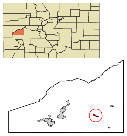
Location of Hotchkiss in Delta County, Colorado.
Coordinates: 38°47′56″N107°42′48″W / 38.79889°N 107.71333°W / 38.79889; -107.71333
Country Flag of the United States.svg  United States
State Flag of Colorado.svg  Colorado
County [1] Delta
Incorporated (town) March 14, 1901 [2]
Government
  Type Statutory Town [1]
  State Representative Marc Catlin
Area
[3]
  Total0.93 sq mi (2.40 km2)
  Land0.93 sq mi (2.40 km2)
  Water0.00 sq mi (0.00 km2)
Elevation
[4]
5,332 ft (1,625 m)
Population
 (2020) [5]
  Total875
  Density940/sq mi (360/km2)
Time zone UTC-7 (MST)
  Summer (DST) UTC-6 (MDT)
ZIP code [6]
81419
Area code 970
FIPS code 08-37545
GNIS feature ID2412771 [4]
Website townofhotchkiss.com

Hotchkiss is a statutory town in Delta County, Colorado, United States. The population was 875 at the 2020 census. [5]

Contents

A post office called Hotchkiss has been in operation since 1882. [7] The town is named after Enos T. Hotchkiss, a local pioneer. [8]

Geography

Hotchkiss is located in eastern Delta County on the north side of the North Fork Gunnison River.

Colorado State Highway 92 passes through the center of town as Bridge Street, leading west 20 miles (32 km) to Delta, the county seat, and southeast 52 miles (84 km) to U.S. Route 50 at Blue Mesa Reservoir. Colorado State Highway 133 starts at the east end of town and leads northeast 66 miles (106 km) over McClure Pass to Carbondale.

According to the United States Census Bureau, the town of Hotchkiss has a total area of 0.93 square miles (2.4 km2), all of it land. [9]

Demographics

Historical population
CensusPop.Note
1900 261
1910 600129.9%
1920 572−4.7%
1930 541−5.4%
1940 65320.7%
1950 7159.5%
1960 626−12.4%
1970 507−19.0%
1980 84967.5%
1990 744−12.4%
2000 96830.1%
2010 944−2.5%
2020 875−7.3%

Schools

The Delta County School District Board of Education decided in February 2021 to close separate high schools in Hotchkiss and Paonia, Colorado and build a joint high school, North Fork High School, located in Hotchkiss. Both schools have been losing students as coal mines in the area have closed. Kindergarten to 8th grade education will continue in both communities. [10]

See also

Related Research Articles

<span class="mw-page-title-main">Delta County, Colorado</span> County in Colorado, United States

Delta County is a county located in the U.S. state of Colorado. As of the 2020 census, the population was 31,196. The county seat is Delta.

<span class="mw-page-title-main">Salida, Colorado</span> City in Colorado, United States

Salida is the statutory city that is the county seat and the most populous municipality of Chaffee County, Colorado, United States. The population was 5,666 at the 2020 census.

<span class="mw-page-title-main">Romeo, Colorado</span> Town in Colorado, United States

Romeo is a Statutory Town in Conejos County, Colorado, United States. The population was 302 at the 2020 census. A post office called Romeo was established in 1901. The community derives its name from the surname Romero.

<span class="mw-page-title-main">Ordway, Colorado</span> Town in and county seat of Crowley County, Colorado, United States

Ordway is a Statutory Town in and the county seat of Crowley County, Colorado, United States, that is also the most populous community in the county. The population was 1,066 at the 2020 census.

<span class="mw-page-title-main">Delta, Colorado</span> City in Colorado, United States

Delta is a home rule municipality that is the county seat and the most populous municipality of Delta County, Colorado, United States. The town population was 9,035 at the 2020 United States Census. The United States Forest Service headquarters of the Grand Mesa, Gunnison, and Uncompahgre National Forests are located in Delta.

<span class="mw-page-title-main">Orchard City, Colorado</span> Town in Colorado, United States

Orchard City is a statutory town in Delta County, Colorado, United States. The population was 3,142 at the 2020 census. There are three post offices serving Orchard City: Austin, Cory, Eckert.

<span class="mw-page-title-main">Paonia, Colorado</span> Town in Colorado, United States

Paonia is a statutory town in Delta County, Colorado, United States. The population was 1,447 at the 2020 census.

<span class="mw-page-title-main">Rico, Colorado</span> Town in Colorado, United States

Rico is a town in Dolores County, Colorado, United States. It was settled in 1879 as a silver mining center in the Pioneer Mining District; today it functions as a historic and tourism site. The population was 288 at the 2020 census. Its current form of government is that of a home rule municipality.

<span class="mw-page-title-main">Florence, Colorado</span> City in Colorado, United States

The City of Florence is a statutory city located in Fremont County, Colorado, United States. The city population was 3,822 at the 2020 United States Census. Florence is a part of the Cañon City, CO Micropolitan Statistical Area and the Front Range Urban Corridor.

<span class="mw-page-title-main">Silt, Colorado</span> Town in Colorado, United States

Silt is a statutory town in Garfield County, Colorado, United States. The population was 3,536 at the 2020 census, up from 2,930 at the 2010 census. The town is part of the Glenwood Springs Micropolitan Area.

<span class="mw-page-title-main">Sheridan Lake, Colorado</span> Town in Colorado, United States

Sheridan Lake is a Statutory Town located in Kiowa County, Colorado, United States. The population was 55 at the 2020 census.

<span class="mw-page-title-main">Atwood, Colorado</span> Census Designated Place in Colorado, United States

Atwood is an unincorporated town, a post office, and a census-designated place (CDP) located in and governed by Logan County, Colorado, United States. The CDP is a part of the Sterling, CO Micropolitan Statistical Area. The Atwood post office has the ZIP Code 80722. At the United States Census 2020, the population of the Atwood CDP was 138.

<span class="mw-page-title-main">Olathe, Colorado</span> Town in Montrose County, Colorado, United States

Olathe is a statutory town in Montrose County, Colorado, United States. The population was 2,019 as of the 2020 census, up from 1,849 at the 2010 census. A post office called Olathe has been in operation since 1896. The community was named after Olathe, Kansas.

<span class="mw-page-title-main">Wray, Colorado</span> City in Colorado, United States

Wray is the home rule municipality that is the county seat of Yuma County, Colorado, United States. Located in the Colorado Plains, the city is 170 miles east of Denver, 9 miles west of the Nebraska state line, and 25 miles northwest of the Kansas state line. The population was 2,358 at the 2020 United States census.

<span class="mw-page-title-main">North Fork Gunnison River</span> River in Colorado, United States

The North Fork Gunnison River is a tributary of the Gunnison River, 33.5 miles (53.9 km) long, in southwestern Colorado in the United States. It drains part of the southwestern flank of the Elk Mountains northeast of Delta.

<span class="mw-page-title-main">Idalia, Colorado</span> Unincorporated community in Colorado, United States

Idalia is an unincorporated town, a post office, and a census-designated place (CDP) located in Yuma County, Colorado, United States. The Idalia post office has the ZIP Code 80735. At the United States Census 2020, the population of the Idalia CDP was 97.

<span class="mw-page-title-main">Orchard, Colorado</span> Unincorporated community in Colorado, United States

Orchard is an unincorporated town, a post office, and a census-designated place (CDP) located in and governed by Morgan County, Colorado, United States. The CDP is a part of the Fort Morgan, CO Micropolitan Statistical Area. The Orchard post office has the ZIP Code 80649. As of the 2020 census, the population of the Orchard CDP was 76.

<span class="mw-page-title-main">Weston, Colorado</span> Census Designated Place in Colorado, United States

Weston is an unincorporated town, a post office, and a census-designated place (CDP) located in and governed by Las Animas County, Colorado, United States. The Weston post office has the ZIP Code 81091. At the United States Census 2020, the population of the Weston CDP was 53.

<span class="mw-page-title-main">Wolcott, Colorado</span> Census Designated Place in Colorado, United States

Wolcott is an unincorporated town, a post office, and a census-designated place (CDP) located in and governed by Eagle County, Colorado, United States. The CDP is a part of the Edwards, CO Micropolitan Statistical Area. The Wolcott post office has the ZIP Code 81655. At the United States Census 2020, the population of the Wolcott CDP was 20.

<span class="mw-page-title-main">Towner, Colorado</span> Census-designated place in Kiowa County, Colorado, United States

Towner is a census-designated place (CDP) in and governed by Kiowa County, Colorado, United States. The population of the Towner CDP was 18 at the United States Census 2020. The Sheridan Lake post office serves Towner postal addresses. Towner's post office closed down in 1992.

References

  1. 1 2 "Active Colorado Municipalities". State of Colorado, Department of Local Affairs. Archived from the original on December 12, 2009. Retrieved September 1, 2007.
  2. "Colorado Municipal Incorporations". State of Colorado, Department of Personnel & Administration, Colorado State Archives. December 1, 2004. Retrieved September 2, 2007.
  3. "2019 U.S. Gazetteer Files". United States Census Bureau. Retrieved July 1, 2020.
  4. 1 2 U.S. Geological Survey Geographic Names Information System: Hotchkiss, Colorado
  5. 1 2 United States Census Bureau. "Hotchkiss town, Colorado" . Retrieved April 7, 2023.
  6. "ZIP Code Lookup". United States Postal Service. Archived from the original (JavaScript/HTML) on November 4, 2010. Retrieved October 6, 2007.
  7. "Post offices". Jim Forte Postal History. Retrieved June 27, 2016.
  8. Dawson, John Frank. Place names in Colorado: why 700 communities were so named, 150 of Spanish or Indian origin. Denver, CO: The J. Frank Dawson Publishing Co. p. 27.
  9. "Geographic Identifiers: 2010 Demographic Profile Data (G001): Hotchkiss town, Colorado". U.S. Census Bureau, American Factfinder. Retrieved October 15, 2015.[ dead link ]
  10. Nathan Deal (February 27, 2021). "Hotchkiss, Paonia high schools to merge". Grand Junction Sentinel. Retrieved May 16, 2021. "We're going to have a kindergarten-eighth grade school in Paonia, a kindergarten-eighth grade school in Hotchkiss, and then there will be one high school in Hotchkiss next year."