Grand County, Colorado

Last updated

Grand County
Grand County Judicial Center.JPG
The Grand County Judicial Center in Hot Sulphur Springs, July 2016
Grand County co seal.png
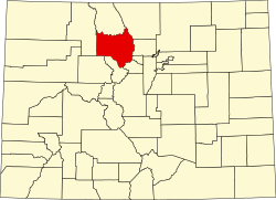
Map of Colorado highlighting Grand County.svg
Location within the U.S. state of Colorado
Colorado in United States.svg
Colorado's location within the U.S.
Coordinates: 40°06′N106°07′W / 40.10°N 106.12°W / 40.10; -106.12
CountryFlag of the United States.svg United States
StateFlag of Colorado.svg  Colorado
FoundedFebruary 2, 1874
Named for Grand Lake and Grand River
Seat Hot Sulphur Springs
Largest town Granby
Area
  Total1,870 sq mi (4,800 km2)
  Land1,846 sq mi (4,780 km2)
  Water23 sq mi (60 km2)  1.2%
Population
 (2020)
  Total15,717
  Density8.5/sq mi (3.3/km2)
Time zone UTC−7 (Mountain)
  Summer (DST) UTC−6 (MDT)
Congressional district 2nd
Website co.grand.co.us
Whiteley Peak along U.S. Highway 40 north of Kremmling Whiteley Peak.JPG
Whiteley Peak along U.S. Highway 40 north of Kremmling

Grand County is a county located in the U.S. state of Colorado. As of the 2020 census, the population was 15,717. [1] The county seat is Hot Sulphur Springs. [2]

Contents

History

When Grand County was created on February 2, 1874, it was carved out of Summit County and contained land to the western and northern borders of the state, which is in present-day Moffat County and Routt County. It was named after Grand Lake and the Grand River, [3] an old name for the upper Colorado River, which has its headwaters in the county. On January 29, 1877, Routt County was created and Grand County shrunk down to its current western boundary. When valuable minerals were found in North Park, Grand County claimed the area as part of its county, a claim Larimer County also held. It took a decision by the Colorado Supreme Court in 1886 to declare North Park part of Larimer County, setting Grand County's northern boundary.

In 2004, Marvin John Heemeyer, a local businessman from Granby, used a modified bulldozer to destroy parts of the town of Granby. This was after Heemeyer lawsuit against the town alleging the government ruined his business was dismissed. [4] His attack ended when one of the bulldozer tracks became inoperable and he committed suicide.

Geography

According to the U.S. Census Bureau, the county has a total area of 1,870 square miles (4,800 km2), of which 1,846 square miles (4,780 km2) is land and 23 square miles (60 km2) (1.2%) is water. [5]

Adjacent counties

Major highways

National protected areas

Bicycle routes

Scenic byways

Historical population
CensusPop.Note
1880 417
1890 60444.8%
1900 74122.7%
1910 1,862151.3%
1920 2,65942.8%
1930 2,108−20.7%
1940 3,58770.2%
1950 3,96310.5%
1960 3,557−10.2%
1970 4,10715.5%
1980 7,47582.0%
1990 7,9666.6%
2000 12,44256.2%
2010 14,84319.3%
2020 15,7175.9%
2023 (est.)15,935 [6] 1.4%
U.S. Decennial Census [7]
1790-1960 [8] 1900-1990 [9]
1990-2000 [10] 2010-2020 [1]

Demographics

At the 2000 census, there were 12,442 people in 5,075 households, including 3,217 families, in the county. The population density was 7 people per square mile (2.7 people/km2). There were 10,894 housing units at an average density of 6 units per square mile (2.3 units/km2). The racial makeup of the county was 95.15% White, 0.48% Black or African American, 0.43% Native American, 0.68% Asian, 0.10% Pacific Islander, 2.00% from other races, and 1.15% from two or more races. 4.36% of the population were Hispanic or Latino of any race. 23.8% were of German, 12.6% Irish, 10.0% English and 7.3% American ancestry. [11] Of the 5,075 households 28.10% had children under the age of 18 living with them, 54.70% were married couples living together, 5.20% had a female householder with no husband present, and 36.60% were non-families. 24.80% of households were one person and 4.80% were one person aged 65 or older. The average household size was 2.37 and the average family size was 2.85.

The age distribution was 21.80% under the age of 18, 9.00% from 18 to 24, 34.70% from 25 to 44, 26.80% from 45 to 64, and 7.80% 65 or older. The median age was 37 years. For every 100 females there were 112.70 males. For every 100 females age 18 and over, there were 115.70 males.

The median household income was $47,759 and the median family income was $55,217. Males had a median income of $34,861 versus $26,445 for females. The per capita income for the county was $25,198. About 5.40% of families and 7.30% of the population were below the poverty line, including 7.90% of those under age 18 and 6.10% of those age 65 or over.

Politics

Unlike many counties dominated by a ski town, Grand County leans Republican. However, the town of Winter Park, where the Winter Park Ski Resort is located, is solidly Democratic.

United States presidential election results for Grand County, Colorado [12]
Year Republican Democratic Third party
No.%No.%No.%
2020 4,88349.47%4,71047.72%2772.81%
2016 4,49452.33%3,35839.10%7368.57%
2012 4,25351.95%3,68445.00%2503.05%
2008 4,12849.68%4,03748.59%1441.73%
2004 4,26055.99%3,24342.62%1061.39%
2000 3,57056.19%2,30836.33%4757.48%
1996 2,26446.30%2,01241.15%61412.56%
1992 1,76335.85%1,67834.12%1,47730.03%
1988 2,30660.08%1,45137.81%812.11%
1984 2,86572.72%1,01725.81%581.47%
1980 2,13361.28%82023.56%52815.17%
1976 1,70361.77%91033.01%1445.22%
1972 1,72169.93%68527.83%552.23%
1968 1,16767.38%43325.00%1327.62%
1964 81447.22%90252.32%80.46%
1960 1,10462.62%65737.27%20.11%
1956 1,23971.33%49628.55%20.12%
1952 1,33370.34%55429.23%80.42%
1948 77749.74%76348.85%221.41%
1944 96863.52%55436.35%20.13%
1940 1,07455.19%86344.35%90.46%
1936 71445.54%84653.95%80.51%
1932 59842.87%77155.27%261.86%
1928 77062.15%45136.40%181.45%
1924 68154.31%30824.56%26521.13%
1920 64952.51%55344.74%342.75%
1916 37837.17%62461.36%151.47%
1912 24825.78%50752.70%20721.52%
1908 52951.31%48747.24%151.45%
1904 47563.16%26635.37%111.46%
1900 17148.17%18251.27%20.56%
1896 124.53%25194.72%20.75%
1892 10443.70%00.00%13456.30%
1888 16264.80%8333.20%52.00%
1884 24958.18%17440.65%51.17%
1880 12157.08%8741.04%41.89%

Communities

The Fraser Valley in eastern Grand County is a key tourist area. Fraser Valley.jpg
The Fraser Valley in eastern Grand County is a key tourist area.

Towns

Census-designated places

Other

See also

Related Research Articles

<span class="mw-page-title-main">Summit County, Colorado</span> County in Colorado, United States

Summit County is a county located in the U.S. state of Colorado. As of the 2020 census, the population was 31,055. The county seat and largest town is Breckenridge.

<span class="mw-page-title-main">Routt County, Colorado</span> County in Colorado, United States

Routt County is a county located in the U.S. state of Colorado. As of the 2020 census, the population was 24,829. The county seat is Steamboat Springs. Routt County comprises the Steamboat Springs, CO Micropolitan Statistical Area.

<span class="mw-page-title-main">Rio Blanco County, Colorado</span> County in Colorado, United States

Rio Blanco County is a county located in the U.S. state of Colorado. As of the 2020 census, the population was 6,529. The county seat is Meeker. The name of the county is the Spanish name for the White River which runs through it.

<span class="mw-page-title-main">Moffat County, Colorado</span> County in Colorado, United States

Moffat County is a county located in the U.S. state of Colorado. As of the 2020 census, the population was 13,292. The county seat is Craig. With an area of 4,751 square miles, it is the second-largest county by area in Colorado, behind Las Animas County.

<span class="mw-page-title-main">Mesa County, Colorado</span> County in Colorado, United States

Mesa County is a county located in the U.S. state of Colorado. As of the 2020 census, the population was 155,703. The county seat and most populous municipality is Grand Junction. The county was named for the many large mesas in the area, including the Grand Mesa, which is the largest flat-topped mountain in the world.

<span class="mw-page-title-main">Larimer County, Colorado</span> County in Colorado, United States

Larimer County is a county located in the U.S. state of Colorado. As of the 2020 census, the population was 359,066. The county seat and most populous city is Fort Collins. The county was named for William Larimer, Jr., the founder of Denver.

<span class="mw-page-title-main">Lake County, Colorado</span> County in Colorado, United States

Lake County is a county located in the U.S. state of Colorado. As of the 2020 census, the population was 7,436. The county seat and the only municipality in the county is Leadville. The highest natural point in Colorado and the entire Rocky Mountains is the summit of Mount Elbert in Lake County at 14,440 feet elevation.

<span class="mw-page-title-main">Jackson County, Colorado</span> County in Colorado, United States

Jackson County is a county located in the U.S. state of Colorado. As of the 2020 census, the population was 1,379, and it was the fourth least populated in the state. The county is named after the United States President Andrew Jackson. The county seat and only municipality in the county is Walden.

<span class="mw-page-title-main">Huerfano County, Colorado</span> County in Colorado, United States

Huerfano County is a county located in the U.S. state of Colorado. As of the 2020 census, the population was 6,820. The county seat is Walsenburg. The county, whose name comes from the Spanish huérfano meaning "orphan", was named for the Huerfano Butte, a local landmark. The area of Huerfano County boomed early in the 1900s with the discovery of large coal deposits. After large scale World War II coal demand ended in the 1940s Walsenburg and Huerfano saw a steady economic decline through 2015.

<span class="mw-page-title-main">Gunnison County, Colorado</span> County in Colorado, United States

Gunnison County is a county located in the U.S. state of Colorado. As of the 2020 census, the population was 16,918. The county seat is Gunnison. The county was named for John W. Gunnison, a United States Army officer and captain in the Army Topographical Engineers, who surveyed for the transcontinental railroad in 1853.

<span class="mw-page-title-main">Gilpin County, Colorado</span> County in Colorado, United States

Gilpin County is a county located in the U.S. state of Colorado, smallest in land area behind only the City and County of Broomfield. As of the 2020 census, the population was 5,808. The county seat is Central City. The county was formed in 1861, while Colorado was still a territory, and was named after Colonel William Gilpin, the first territorial governor.

<span class="mw-page-title-main">Garfield County, Colorado</span> County in Colorado, United States

Garfield County is a county located in the U.S. state of Colorado. As of the 2020 census, the population was 61,685. The county seat is Glenwood Springs. The county is named in honor of United States President James A. Garfield. Garfield County is included in the Glenwood Springs, CO Micropolitan Statistical Area, which is also included in the Edwards-Glenwood Springs, CO Combined Statistical Area.

<span class="mw-page-title-main">Eagle County, Colorado</span> County in Colorado, United States

Eagle County is a county located in the U.S. state of Colorado. As of the 2020 census, the population was 55,731. The county seat is the Town of Eagle and the most populous community is Edwards. The county is named for the Eagle River.

<span class="mw-page-title-main">Delta County, Colorado</span> County in Colorado, United States

Delta County is a county located in the U.S. state of Colorado. As of the 2020 census, the population was 31,196. The county seat is Delta.

<span class="mw-page-title-main">Clear Creek County, Colorado</span> County in Colorado, United States

Clear Creek County is a county located in the U.S. state of Colorado. As of the 2020 census, the population was 9,397. The county seat is Georgetown.

<span class="mw-page-title-main">Chaffee County, Colorado</span> County in Colorado, United States

Chaffee County is a county located in the U.S. state of Colorado. As of the 2020 census, the population was 19,476. The county seat is Salida.

<span class="mw-page-title-main">Boulder County, Colorado</span> County in Colorado, United States

Boulder County is a county located in the U.S. state of Colorado of the United States. As of the 2020 census, the population was 330,758. The most populous municipality in the county and the county seat is Boulder.

<span class="mw-page-title-main">Alamosa County, Colorado</span> County in Colorado, United States

Alamosa County is a county located in the U.S. state of Colorado. As of the 2020 census, the population was 16,376. The county seat is Alamosa. The county name is the Spanish language word for a grove of cottonwood trees.

<span class="mw-page-title-main">Granby, Colorado</span> Town in Colorado, United States

The Town of Granby is the Statutory Town that is the most populous municipality in Grand County, Colorado, United States. The town population was 2,079 at the 2020 United States Census. Granby is situated along U.S. Highway 40 in the Middle Park basin, and it is about 85 miles (137 km) northwest of Denver and 14 miles (23 km) southwest of Rocky Mountain National Park.

<span class="mw-page-title-main">Roosevelt National Forest</span> National forest located in north central Colorado

The Roosevelt National Forest is a National Forest located in north central Colorado. It is contiguous with the Colorado State Forest as well as the Arapaho National Forest and the Routt National Forest. The forest is administered jointly with the Arapaho National Forest and the Pawnee National Grassland from offices in Fort Collins, and is denoted by the United States Forest Service as ARP.

References

  1. 1 2 "State & County QuickFacts". United States Census Bureau. Retrieved September 5, 2021.
  2. "Find a County". National Association of Counties. Archived from the original on May 31, 2011. Retrieved June 7, 2011.
  3. Gannett, Henry (1905). The Origin of Certain Place Names in the United States. Govt. Print. Off. pp.  141.
  4. "Marvin Heemeyer Wanted Revenge — So He Built A 'Killdozer'". February 8, 2022.
  5. "US Gazetteer files: 2010, 2000, and 1990". United States Census Bureau. February 12, 2011. Retrieved April 23, 2011.
  6. "Annual Estimates of the Resident Population for Counties: April 1, 2020 to July 1, 2023". United States Census Bureau. Retrieved March 31, 2024.
  7. "U.S. Decennial Census". United States Census Bureau. Retrieved June 8, 2014.
  8. "Historical Census Browser". University of Virginia Library. Retrieved June 8, 2014.
  9. "Population of Counties by Decennial Census: 1900 to 1990". United States Census Bureau. Retrieved June 8, 2014.
  10. "Census 2000 PHC-T-4. Ranking Tables for Counties: 1990 and 2000" (PDF). United States Census Bureau. Archived (PDF) from the original on March 27, 2010. Retrieved June 8, 2014.
  11. "U.S. Census website". United States Census Bureau . Retrieved May 14, 2011.
  12. Leip, David. "Dave Leip's Atlas of U.S. Presidential Elections". uselectionatlas.org. Retrieved May 26, 2017.