Tabernash, Colorado | |
|---|---|
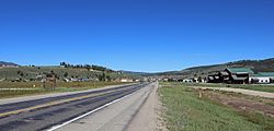 Tabernash in 2016. | |
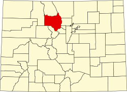
 Location of the Tabernash CDP in Grand County, Colorado. | |
 Tabernash Location of the Tabernash CDP in the United States. | |
| Coordinates: 39°58′44″N105°50′39″W / 39.97889°N 105.84417°W [1] | |
| Country | United States |
| State | Colorado |
| County | Grand County |
| Government | |
| • Type | unincorporated town |
| Area | |
• Total | 4.747 sq mi (12.295 km2) |
| • Land | 4.747 sq mi (12.295 km2) |
| • Water | 0.000 sq mi (0.000 km2) |
| Elevation | 8,403 ft (2,561 m) |
| Population | |
• Total | 401 |
| • Density | 84/sq mi (33/km2) |
| Time zone | UTC-7 (MST) |
| • Summer (DST) | UTC-6 (MDT) |
| ZIP Code [4] | 80478 |
| Area code | 970 |
| GNIS feature ID | 2410044 [1] |
Tabernash is an unincorporated town, a post office, and a census-designated place (CDP) located in and governed by Grand County, Colorado, United States. The Tabernash post office has the ZIP Code 80478. [4] At the United States Census 2020, the population of the Tabernash CDP was 401. [3]