El Paso County, Colorado

Last updated

El Paso County
El Paso County Justice Center by David Shankbone.jpg
El Paso County Justice Center
El Paso County, CO Flag.gif
El Paso County, CO Seal.png
Map of Colorado highlighting El Paso County.svg
Location within the U.S. state of Colorado
Colorado in United States.svg
Colorado's location within the U.S.
Coordinates: 38°50′N104°31′W / 38.84°N 104.52°W / 38.84; -104.52
CountryFlag of the United States.svg United States
StateFlag of Colorado.svg  Colorado
FoundedNovember 1, 1861
Named for Spanish name for The Pass
Seat Colorado Springs
Largest cityColorado Springs
Area
  Total
2,130 sq mi (5,500 km2)
  Land2,127 sq mi (5,510 km2)
  Water2.7 sq mi (7 km2)  0.1%
Population
 (2020)
  Total
730,395
  Estimate 
(2023)
744,215 Increase2.svg
  Density340/sq mi (130/km2)
Time zone UTC−7 (Mountain)
  Summer (DST) UTC−6 (MDT)
Congressional districts 4th, 5th, 7th
Website www.elpasoco.com
An isolated rural house next to a mountain in northern El Paso County. House in the mountains, El Paso County, CO IMG 5162.JPG
An isolated rural house next to a mountain in northern El Paso County.
Summer greenery of El Paso County Greenery of El Paso County, CO IMG 5163.JPG
Summer greenery of El Paso County

El Paso County is the most populous county in the U.S state of Colorado. As of the 2020 census, the population was 730,395, [1] surpassing the city and county of Denver. The county seat is Colorado Springs, [2] the second most populous city in Colorado. El Paso County is included in the Colorado Springs, Colorado, Metropolitan Statistical Area.

Contents

History

In July 1858, gold was discovered along the South Platte River in Arapahoe County, Kansas Territory. This discovery precipitated the Pike's Peak Gold Rush. Many residents of the mining region felt disconnected from the remote territorial governments of Kansas and Nebraska, so they voted to form their own Territory of Jefferson on October 24, 1859. The following month, the Jefferson Territorial Legislature organized 12 counties for the new territory including El Paso County. El Paso County was named for the Spanish language name for Ute Pass north of Pikes Peak. Colorado City served as the county seat of El Paso County.

The Jefferson Territory never received federal sanction, but on February 28, 1861, U.S. President James Buchanan signed an act organizing the Territory of Colorado. [3] El Paso County was one of the original 17 counties created by the Colorado legislature on November 1, 1861. Part of its western territory was broken off to create Teller County in 1899. Originally based in Old Colorado City (now part of Colorado Springs, not today's Colorado City between Pueblo and Walsenburg), El Paso County's county seat was moved to Colorado Springs in 1873.

Geography

El Paso County Fairgrounds in Calhan, Colorado El Paso County Fairground.jpg
El Paso County Fairgrounds in Calhan, Colorado

According to the United States Census Bureau, the county has a total area of 2,130 square miles (5,500 km2), of which 2,127 square miles (5,510 km2) are land and 2.7 square miles (7.0 km2) (0.1%) are covered by water. [4]

Adjacent counties

Major highways

National protected area

Pikes Peak dominates the county's skyline. Pikes Peak from Colorado Springs by David Shankbone.jpg
Pikes Peak dominates the county's skyline.

State protected area

Historic sites

Trails

Demographics

Historical population
CensusPop.Note
1870 987
1880 7,949705.4%
1890 21,239167.2%
1900 31,60248.8%
1910 43,32137.1%
1920 44,0271.6%
1930 49,57012.6%
1940 54,0259.0%
1950 74,52337.9%
1960 143,74292.9%
1970 235,97264.2%
1980 309,42431.1%
1990 397,01428.3%
2000 516,92930.2%
2010 622,26320.4%
2020 730,39517.4%
2023 (est.)744,215 [5] 1.9%
U.S. Decennial Census [6]
1790–1960 [7] 1900–1990 [8]
1990–2000 [9] 2010-2020 [1]

2020 census

As of the 2020 census, there were 730,395 people, 272,683 households, and 185,830 families residing in the county. [10] The population density was 343.5 people per square mile (132.6 people/km2). There were 287,459 housing units. The racial makeup of the county was 82.6% White, 6.9% Black or African American, 1.4% Native American, 3.4% Asian, 0.4% Pacific Islander, and 5.4% from two or more races. About 18.9% of the population was Hispanic or Latino of any race.

In El Paso county, the population pyramid was distributed as there being a slight surplus of males ages 0 to 45 and there after a slight surplus of females which is typical of most US populations. The greater than normal surplus of males between 18 and 35 are mainly due to the presence of five military installations located within the county. [11]

El Paso County Colorado Population Pyramid El Paso County Colorado Population Pyramid.png
El Paso County Colorado Population Pyramid

Education

K-12 Education

El Paso County is home to 17 public school districts, in addition to several private schools. In the 2023–2024 school year, Cheyenne Mountain School District 12 in Colorado Springs was ranked the #1 public school district in Colorado. Academy School District 20 (Colorado Springs) and Lewis-Palmer School District 38 (Monument) were ranked #8 and #10, respectively. [12]

Higher Education

El Paso County is home to several colleges and universities. The United States Air Force Academy is located immediately north of Colorado Springs, serving as both a university and a functional U.S. Air Force base. Also in the county are the University of Colorado–Colorado Springs, Colorado College, Pikes Peak State College, Colorado Technical University, and IntelliTec College, all located in Colorado Springs.

Government

El Paso County Justice Center in Colorado Springs El Paso County Justice Center by David Shankbone.jpg
El Paso County Justice Center in Colorado Springs

El Paso County is located in Colorado's 5th congressional district, except for the far eastern extremities, which are located in the 4th. The county is governed by a board of county commissioners. Its current members are Holly Williams in district 1, Carrie Geitner in district 2, Stan VanderWerf in district 3, Longinos Gonzales Jr in district 4, and Cami Bremer in district 5.

In 2004, the voters of Colorado Springs and El Paso County established the Pikes Peak Rural Transportation Authority (PPRTA) and adopted a 1% sales tax dedicated to improving the region's transportation infrastructure. Together with state funding for COSMIX (2007 completion) and the I-25 interchange with Highway 16 (2008 completion), significant progress has been made since 2003 in addressing the transportation needs of the area. In 2012, the county voted to legalize marijuana. [13] On March 12, 2019, the county commissioners unanimously passed a resolution to become a Second Amendment sanctuary. [14]

The Colorado Department of Corrections has its headquarters in an unincorporated area in the county. [15] [16]

Elected Officials

PositionElected Official
County Commissioner District 1Holly Williams
County Commissioner District 2Carrie Geitner
County Commissioner District 3Stan VanderWerf
County Commissioner District 4Longinos Gonzalez Jr.
County Commissioner District 5Cami Bremer
County AssessorMark Flutcher
County Clerk and RecorderSteve Schleiker
County CoronerLeon Kelly
County Sheriff Sheriff Joseph Roybal
County SurveyorRichard Mariotti
County TreasurerChuck Broerman

El Paso County lies within the 4th Judicial District which is represented by District Attorney Michael Allen. [17]

Top employers

According to the City's 2022 Comprehensive Annual Financial Report, [18] the largest employers in the county are:

#Employer# of EmployeesPercentage
1 Fort Carson 36,0009.35%
2 Peterson Space Force Base 10,6502.77%
3 Schriever Space Force Base 8,0002.08%
4 United States Air Force Academy 7,6501.99%
5 UCHealth Memorial Health Services6,0001.56%
6The Charter Spectrum West Region4,9001.27%
7 Amazon 4,8001.25%
8 Penrose Hospital 3,5600.92%
9 Colorado Springs School District 11 3,3000.86%
10 Academy School District 20 3,1500.82%
Total88,01022.87%

Politics

United States presidential election results for El Paso County, Colorado [19]
Year Republican Democratic Third party(ies)
No.%No.%No.%
2024 203,93353.53%166,59743.73%10,4562.74%
2020 202,82853.54%161,94142.75%14,0823.72%
2016 179,22856.19%108,01033.86%31,7309.95%
2012 170,95258.91%111,81938.54%7,4042.55%
2008 160,31858.69%108,89939.86%3,9581.45%
2004 161,36166.74%77,64832.11%2,7791.15%
2000 128,29463.91%61,79930.78%10,6645.31%
1996 102,40359.04%55,82232.19%15,2168.77%
1992 86,04451.47%45,82727.41%35,29821.12%
1988 96,96570.03%39,99528.88%1,5061.09%
1984 88,37775.04%28,18523.93%1,2101.03%
1980 66,19963.66%27,46326.41%10,3289.93%
1976 50,92959.13%32,91138.21%2,2902.66%
1972 53,89269.11%21,23427.23%2,8593.67%
1968 32,06653.75%21,23235.59%6,35710.66%
1964 23,82245.98%27,84453.75%1410.27%
1960 31,62564.93%17,01834.94%610.13%
1956 27,28258.46%18,87940.46%5051.08%
1952 25,27268.71%11,20330.46%3030.82%
1948 15,70555.26%12,29143.25%4231.49%
1944 16,39258.16%11,67941.44%1150.41%
1940 16,76655.31%13,32043.94%2290.76%
1936 10,96539.82%15,65256.84%9203.34%
1932 12,01749.35%11,35346.62%9804.02%
1928 16,24375.28%5,06923.49%2661.23%
1924 10,21555.69%4,14022.57%3,98921.75%
1920 9,53562.78%5,07333.40%5813.83%
1916 7,15943.55%8,38150.99%8975.46%
1912 2,81618.72%5,55936.95%6,67144.34%
1908 8,02253.25%5,99539.79%1,0486.96%
1904 9,58962.07%5,28134.18%5793.75%
1900 7,75553.76%6,23043.19%4393.04%
1896 6,24825.75%17,67272.84%3401.40%
1892 2,65747.39%00.00%2,95052.61%
1888 2,16460.58%1,28135.86%1273.56%
1884 1,20965.71%53429.02%975.27%
1880 1,15165.36%58032.94%301.70%

El Paso is quite conservative for a large urban county, although it has become less so since the 2010s. Its conservative bent predates the influence of its large military and Evangelical Christian populations. Since its creation in 1871, El Paso County has typically voted for the Republican presidential candidate in presidential elections; the last Democratic nominee to win the county was Lyndon B. Johnson in 1964. Even then, Barry Goldwater got nearly 46% of the county's vote. After Johnson carried it in 1964, a Democrat would not win 40 percent of the county's vote again until Joe Biden in 2020. It has voted Republican in every presidential election since 1920, except for the Democratic landslides of 1936 and 1964.

Dick Lamm in 1982 remains the last Democrat to win the county in a gubernatorial election. Eight years later, the county was one of only four in the state to back governor Roy Romer's opponent John Andrews. [20] [21] Jared Polis in 2022 came within 4% of winning the county. The last Democrat to win the county in a Senate election was Gary Hart in 1974. [22]

Libraries

The Pikes Peak Library District provides library services through its 15 branches and bookmobiles to the residents of El Paso County, with the exception of Widefield School District 3. The mission of the District is "Providing resources and opportunities that impact individual lives and build community. Seek. Engage. Transform." [23]

Military installations

El Paso County is home to Army, Air Force and Space Force bases. These military installations border Colorado Springs to the north, south, and east, aside from Schriever Space Force Base, which is located about 10 miles east of Peterson Space Force Base. [24] [ circular reference ]

Fort Carson

Fort Carson, "The Mountain Post", is located just south of Colorado Springs at the base of the Rocky Mountains. It was established in 1942, following Japan's attack on Pearl Harbor. The city of Colorado Springs purchased land south of the city and donated it to the War Department. Construction began immediately and the first building, the camp headquarters, was completed January 31, 1942. Camp Carson was named in honor of the legendary Army scout Gen. Christopher "Kit" Carson, who explored much of the West in the 1800s. Camp Carson became Fort Carson in 1954. An additional training area was purchased in September 1983 and is called Piñon Canyon Maneuver Site (PCMS).

Currently, Fort Carson is the home of 4th Infantry Division and several other units, including 10th Special Forces Group (Airborne), the Colorado National Guard Regional Training Institute and PCMS, which is a maneuver training site for Fort Carson located near Trinidad, Colorado. The installation totals about 137,000 acres and PCMS is roughly 236,000 acres. Fort Carson has around 3,000 family housing units and 66 soldier barracks with 8,132 rooms. Services on the installation include four elementary schools, one middle school, a commissary, an exchange, and Evans Army Community Hospital, as well as Army Community Service facilities to include child development centers and youth centers and family morale, welfare, and recreation facilities to include a bowling alley, golf course, and numerous parks.

Fort Carson's economic impact on Colorado Springs and the surrounding communities was approximately $2.3 billion during fiscal year 2014. Fort Carson has about 24,300 soldiers on the installation, with 44,700 family members. The installation also has around 8,000 veterans and 3,300 civilians. [25]

Peterson Space Force Base

AFSPC Headquarters, Peterson AFB, Colorado Springs. PetersonAFB.jpg
AFSPC Headquarters, Peterson AFB, Colorado Springs.

The Space Force has critical aspects of their service based at Colorado Springs, which carry on missile defense operations and development. The Space Force bases a large section of its national missile defense operations here, with Peterson Space Force Base set to operate large sections of the program. The base is also home to Space Force's Space Operations Command, and to NORAD headquarters. Peterson SFB is currently the headquarters of the operations-half of Army Space and Missile Defense Command/Army Strategic Command.[ citation needed ]

Peterson is also headquarters for the United States Northern Command, one of the Unified Combatant Commands, which directs all branches of the U.S. military operations in their area of responsibility, which includes the continental United States, Alaska, Canada, and Mexico. In the event of national emergencies, the President or Secretary of Defense can call upon the command for any required military assistance. Service members from every branch of the US military are stationed at the command.[ citation needed ]

Peterson SFB is the current, possibly temporary home for US Space Command, another Unified Combatant Command, whose area of operations is global operations occurring 50 miles or greater above the Earth.

Schriever Space Force Base (formerly Schriever AFB and Falcon AFB)

Schriever Space Force Base is home to several Space Force mission Deltas, responsible for the operation and support of 175 Department of Defense satellites and installation support to 16 major tenant units, with a workforce of more than 7,700 personnel. [26] It is the location of the Global Positioning System (GPS) master control station and GPS Operations Center [27] and the US Naval Observatory Alternate Master Clock, [28] used to synchronize GPS satellite time. Schriever is also developing parts of national missile defense and runs parts of the annual wargames used by the nation's military.[ citation needed ] The base indirectly contributes an estimated $1 billion to the local Colorado Springs, CO area annually. [29]

United States Air Force Academy

Cadets in front of the Academy Chapel Air Force Academy Oath of Office.jpg
Cadets in front of the Academy Chapel

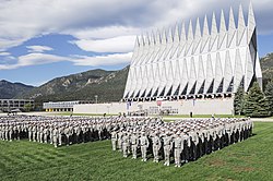
Bordering the northwestern side of the city are the grounds of the United States Air Force Academy, where cadets train to become officers in the Air Force and Space Force. The campus is famous for its unique chapel, and draws visitors year round. Most of the Air Force Academy's sports programs participate in the Mountain West Conference. [30]

Cheyenne Mountain Space Force Station (formerly Air Force Station)

The North American Aerospace Defense Command (NORAD), headquartered on Peterson SFB, has a presence in Cheyenne Mountain Space Force Station. When it was built at the height of the Cold War, NORAD caused some anxiety for the residents in and around Colorado Springs, who believed the installation would be a primary target during a nuclear attack. Although NORAD still operates today, it is primarily given the task of the tracking of ICBMs, and the military has recently decided to place Cheyenne Mountain's NORAD/NORTHCOM operations on warm standby and move operations to nearby Peterson Air Force Base. [31]

Communities

Cities

Towns

Census-designated places

Peyton, Colorado. Peyton Colorado by David Shankbone.jpg
Peyton, Colorado.

Other unincorporated communities

See also

References

  1. 1 2 "State & County QuickFacts". United States Census Bureau. Retrieved March 20, 2024.
  2. "Find a County". National Association of Counties. Archived from the original on July 4, 2012. Retrieved June 7, 2011.
  3. "An Act to provide a temporary Government for the Territory of Colorado" (PDF). Thirty-sixth United States Congress. February 28, 1861. Archived (PDF) from the original on October 25, 2004. Retrieved November 26, 2007.
  4. "US Gazetteer files: 2010, 2000, and 1990". United States Census Bureau. February 12, 2011. Retrieved April 23, 2011.
  5. "Annual Estimates of the Resident Population for Counties: April 1, 2020 to July 1, 2023". United States Census Bureau. Retrieved March 20, 2024.
  6. "U.S. Decennial Census". United States Census Bureau. Retrieved June 7, 2014.
  7. "Historical Census Browser". University of Virginia Library. Retrieved June 7, 2014.
  8. "Population of Counties by Decennial Census: 1900 to 1990". United States Census Bureau. Retrieved June 7, 2014.
  9. "Census 2000 PHC-T-4. Ranking Tables for Counties: 1990 and 2000" (PDF). United States Census Bureau. Archived (PDF) from the original on March 27, 2010. Retrieved June 7, 2014.
  10. "US Census Bureau, Table P16: Household Type". United States Census Bureau. Retrieved March 20, 2024.
  11. "English: El Paso County Colorado Population Pyramid". July 5, 2019.
  12. "2024 Best School Districts in Colorado". Niche.
  13. Breathes, William (November 23, 2012). "Marijuana: Amendment 64 passes in El Paso County by fewer than a dozen votes". westword.com. Retrieved March 16, 2018.
  14. Riley, Rachel (March 12, 2019). "El Paso County declared '2nd Amendment preservation county' as legislature weighs red flag gun bill". Colorado Politics. Retrieved January 18, 2020.
  15. "Contacts".[ permanent dead link ] Colorado Department of Corrections. Retrieved on December 7, 2009.
  16. "Council District Map"; Archived December 1, 2010, at the Wayback Machine . City of Colorado Springs. Retrieved on December 7, 2009.
  17. "About". 4th Judicial District Attorney. Retrieved December 29, 2024.
  18. "County of El Paso 2022 Comprehensive Annual Financial Report" (PDF). March 20, 2024. p. 186.
  19. Leip, David. "Dave Leip's Atlas of U.S. Presidential Elections". uselectionatlas.org. Retrieved May 26, 2017.
  20. Leip, David. "Dave Leip's Atlas of U.S. Presidential Elections". uselectionatlas.org. Retrieved September 27, 2020.
  21. Leip, David. "Dave Leip's Atlas of U.S. Presidential Elections". uselectionatlas.org. Retrieved September 27, 2020.
  22. Leip, David. "Dave Leip's Atlas of U.S. Presidential Elections". uselectionatlas.org. Retrieved September 27, 2020.
  23. "About PPLD | PPLD.org". ppld.org. Retrieved November 20, 2019.
  24. Schriever Air Force Base
  25. "Fort Carson". Fort Carson. Retrieved February 23, 2016.
  26. "Schriever Air Force Base 50th Space Wing". Schriever Air Force Base. Archived from the original on October 21, 2013. Retrieved February 16, 2016.
  27. "GPS Operations Center". Air Force Space Command. Archived from the original on August 23, 2006. Retrieved September 15, 2010.
  28. Staff Sgt. Don Branum (June 15, 2006). "23:59:60...Atomic clock takes quantum leap". Air Force Space Command. Archived from the original on September 30, 2011. Retrieved September 15, 2010.
  29. "Schriever Air Force Base". Schriever Air Force Base. Archived from the original on March 3, 2016. Retrieved February 16, 2016.
  30. themwc.com
  31. Finley, Bruce (July 27, 2006). "Military to put Cheyenne Mountain on standby". The Denver Post. Retrieved October 5, 2009.