Related Research Articles

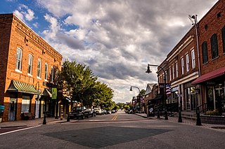
The City of Idaho Springs is the Statutory City that is the most populous municipality in Clear Creek County, Colorado, United States. Idaho Springs is a part of the Denver–Aurora–Lakewood, CO Metropolitan Statistical Area. As of the 2010 census it had a population of 1,717. Idaho Springs is located in Clear Creek Canyon, in the mountains upstream from Golden, some 30 miles (50 km) west of Denver.

Garfield County is a county located in the U.S. state of Colorado. As of the 2020 census, the population was 61,685. The county seat is Glenwood Springs. The county is named in honor of United States President James A. Garfield. Garfield County is included in the Glenwood Springs, CO Micropolitan Statistical Area, which is also included in the Edwards-Glenwood Springs, CO Combined Statistical Area.

El Paso County is a county located in the U.S. state of Colorado. The 2020 Census recorded its population as 730,395. The Census Bureau's 2020 result indicates it is the most populous county in Colorado, surpassing the City and County of Denver. The county seat is Colorado Springs, the second most populous city in Colorado. El Paso County is included in the Colorado Springs, Colorado, Metropolitan Statistical Area and is located in Colorado's 5th congressional district, except for the far eastern extremities, which are located in the 4th.

Eldora, previously known as "Eldorado" then "El-Dora", then Eldora or Camp Eldorado, and still called Happy Valley, is an unincorporated community and a census-designated place (CDP) located in and governed by Boulder County, Colorado, United States. The CDP is a part of the Boulder, CO Metropolitan Statistical Area. The population of the Eldora CDP was 142 at the United States Census 2010. The Nederland post office serves the area.

Black Forest is an unincorporated community and a census-designated place (CDP) located in and governed by El Paso County, Colorado, United States. The CDP is a part of the Colorado Springs, CO Metropolitan Statistical Area. The population of the Black Forest CDP was 15,097 at the United States Census 2020. Both the Colorado Springs post office and the Elbert post office serve the area.

Laurel is a city in and the second county seat of Jones County, Mississippi, United States. As of the 2020 census, the city had a population of 17,161. It is located northeast of Ellisville, the first county seat, which contains the first county courthouse. Laurel has the second county courthouse as there are two judicial districts in Jones County. Laurel is the headquarters of the Jones County Sheriff's Department, which administers in the county. Laurel is the principal city of a micropolitan statistical area named for it. Major employers include Howard Industries, Sanderson Farms, Masonite International, Family Health Center, Howse Implement, Thermo-Kool, and South Central Regional Medical Center. Laurel is home to the Lauren Rogers Museum of Art, Mississippi's oldest art museum, established by the family of Lauren Eastman Rogers.
Wake Forest is a town in Franklin, Granville and Wake counties in the U.S. state of North Carolina; located almost entirely in Wake County, it lies just north of the state capital, Raleigh. At the 2020 census, the population was 47,601. That is up from 30,117 in 2010, up from 12,588 in 2000. The U.S. Census Bureau estimates the city's population to be 47,601 as of April 1, 2020. In 2007, the town was listed by Forbes magazine as the 20th fastest growing suburb in America, with a 73.2 percent increase in population between 2000 and 2006. Wake Forest was the original home of Wake Forest University for 122 years before it moved to Winston-Salem in 1956.

Gould is a small unincorporated community in northwestern Jackson County, Colorado, United States.

The Chippewa River in Wisconsin flows approximately 183 miles (294 km) through west-central and northwestern Wisconsin. It was once navigable for approximately 50 miles (80 km) of its length, from the Mississippi River, by Durand, northeast to Eau Claire. Its catchment defines a portion of the northern boundary of the Driftless Area. The river is easily accessible for bikers and pleasure seekers via the Chippewa River State Trail, which follows the river from Eau Claire to Durand.

Navarro River Redwoods State Park is a state park in Mendocino County, California, consisting of 660 acres (2.7 km2) of second-growth redwood forest in a narrow stretch 11 miles (18 km) long on both banks of the Navarro River, from the town of Navarro to the river's confluence with the Pacific Ocean.

The Black River is a river in west-central Wisconsin and tributary of the Mississippi River. The river is approximately 190 miles (310 km) long. During the 19th century, pine logs were rafted down the Black, heading for sawmills at La Crosse and points beyond.

The Lariat Loop National Scenic and Historic Byway is a National Scenic Byway and a Colorado Scenic and Historic Byway located in Jefferson County, Colorado, USA. The byway is a 40-mile (64 km) loop in the Front Range foothills west of Denver through Golden, Lookout Mountain Park, Genesee Park, Evergreen, Morrison, Red Rocks Park, and Dinosaur Ridge. The Lariat Loop connects to the Mount Evans Scenic Byway at Bergen Park.

KVOR is a commercial radio station in Colorado Springs, Colorado, serving Colorado Springs and Pueblo. It is owned by Cumulus Media and airs a news/talk radio format.

Wanakena is a hamlet located on the shore of Cranberry Lake in the town of Fine in St. Lawrence County, New York, United States. Tourism is a major industry in the area; a small year-round population is supplemented by an influx seasonal residents each summer. It is the location of the SUNY-ESF Ranger School.
Alice Bemis Taylor was a philanthropist and was inducted into the Colorado Women's Hall of Fame in 2010.
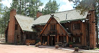
Ponderosa Lodge at La Foret Conference and Retreat Center is a historic lodge in Black Forest, Colorado. It is a National Register of Historic Places listing and is on the Colorado State Register of Historic Properties.

Taylor Memorial Chapel at La Foret Conference and Retreat Center is a historic chapel in Black Forest, Colorado. It is a National Register of Historic Places listing.
Black Rock is an unincorporated community and former logging camp in Polk County, Oregon, United States. It is located about three miles west of Falls City, in the Central Oregon Coast Range on the Little Luckiamute River.

Evergreen Conference District is a music conference center in Jefferson County, Colorado, near Evergreen. It was listed as a historic district on the National Register of Historic Places on May 1, 1979. The district is located at Highway 74 along Bear Creek.

Husted was a settlement on the Denver and Rio Grande Railroad and located thirteen miles north of Colorado Springs at 39°00′35.3″N104°52′54.5″W. Residents were involved in ranching and lumber businesses. In 1878, a railroad post office was moved from Southwater to Husted. The post office closed in 1920.
References
- 1 2 "La Foret". Geographic Names Information System . United States Geological Survey, United States Department of the Interior.
- ↑ "History-La Foret" . Retrieved 29 November 2015.
- ↑ "Black Forest History". Black Forest Preservation Plan. Retrieved 29 November 2015.
Coordinates: 39°00′34″N104°42′52″W / 39.00944°N 104.71444°W