Interstate 80 (I-80) is an east–west transcontinental freeway that crosses the United States from San Francisco, California, to Teaneck, New Jersey, in the New York metropolitan area. The highway was designated in 1956 as one of the original routes of the Interstate Highway System; its final segment was opened in 1986. The second-longest Interstate Highway in the United States after I-90, it runs through many major cities, including Oakland, Sacramento, Reno, Salt Lake City, Omaha, Des Moines, and Toledo and passes within 10 miles (16 km) of Chicago, Cleveland, and New York City.

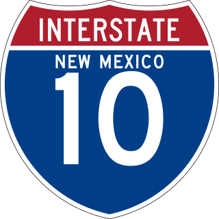
Interstate 10 (I-10) is the southernmost transcontinental highway in the Interstate Highway System. I-10 is the fourth-longest Interstate in the United States at 2,460.34 miles (3,959.53 km), following I-90, I-80, and I-40. This freeway is part of the originally planned network that was laid out in 1956, and its last section was completed in 1990.

U.S. Route 285 is a north–south United States highway, running 846 miles (1,362 km) through the states of Texas, New Mexico and Colorado. The highway's southern terminus is in Sanderson, Texas at an intersection with U.S. Route 90. US 285 has always had an endpoint in Denver, Colorado, although the original US 285 went north from Denver. Today the highway's northern terminus is in Denver, at exit 201 on Interstate 25.

U.S. Route 85 (US 85) is a 1,479-mile-long (2,380 km) north–south United States Highway that travels in the Mountain and Northern Plains states of the United States. The southern terminus of the highway is at the Mexican border in El Paso, Texas, connecting with Mexican Federal Highway 45. The northern terminus is at the Canadian border in Fortuna, North Dakota, where the route continues north as Saskatchewan Highway 35. The highway route is part of the CanAm Highway. Sections of US 85 are designated as the Theodore Roosevelt Expressway.

U.S. Highway 87 is a north–south United States highway that runs for 1,998 miles (3,215 km) from northern Montana to southern Texas, making it the longest north-south road to not have a "1" in its number and the third longest north-south road in the country, behind U.S. 41 and U.S. 1. Most of the portion from Billings, Montana to Raton, New Mexico is co-signed along Interstates 90 and 25. It is also co-signed along the majority of I-27 in Texas and future plans call for the interstate to be extended along the US 87 corridor. As of 2004, the highway's northern terminus is in Havre, Montana, at US 2 and its southern terminus is in Port Lavaca, Texas, at SH 238.

Interstate 180 (I-180) is a 1.09-mile-long (1.75 km) expressway in the US state of Wyoming between I-80 and downtown Cheyenne.

Ratón Pass is a 7,834 ft (2,388 m) elevation mountain pass on the Colorado–New Mexico border in the western United States. It is located on the eastern side of the Sangre de Cristo Mountains between Trinidad, Colorado and Raton, New Mexico, approximately 180 miles (290 km) northeast of Santa Fe. Ratón is Spanish for "mouse". The pass crosses the line of volcanic mesas that extends east from the Sangre de Cristo Mountains along the state line, and furnishes the most direct land route between the valley of the Arkansas River to the north and the upper valley of the Canadian River, leading toward Santa Fe, to the south. The pass now carries Interstate 25 and railroad tracks.
New Mexico State Road 14 (NM 14) is an approximately 54-mile-long (87 km) state road located in northern New Mexico. The highway connects Albuquerque to Santa Fe and comprises most of the Turquoise Trail, a National Scenic Byway which also includes NM 536.
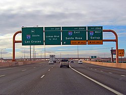
Interstate 10 (I-10) in the US state of New Mexico is a 164.264-mile (264.357 km) long route of the United States Interstate Highway System. I-10 traverses southern New Mexico through Hidalgo, Grant, Luna, and Doña Ana counties. The interstate travels west–east from the Arizona state line to the interchange with I-25 in Las Cruces, and then travels north–south to the Texas state line. US Route 80 in New Mexico (US 80) was replaced by I-10.

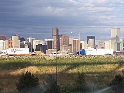
The Southern Rocky Mountain Front is a megaregion of the United States, otherwise known as a megalopolis, with population centers consisting mainly of the Front Range Urban Corridor and the Albuquerque–Santa Fe–Los Alamos combined statistical area, located along the eastern and southern face of the Southern Rocky Mountains in the U.S. states of Wyoming, Colorado, and New Mexico. The region comprises the southern portion of the Rocky Mountain Front geographic region of Canada and the United States, extending into the Southwestern United States. The Southern Rocky Mountain Front had a population of 5,467,633 according to the 2010 United States census. The region is one of the fastest-growing regions in the United States, and its population is projected to grow by 87% to 10,222,370 by 2050. In 2005 the GDP of the region was $229,202,000,000 making up 2% of the United States GDP.

Interstate 25 (I-25) in the US state of New Mexico follows the north–south corridor through Albuquerque and Santa Fe. It replaced U.S. Route 85 (US 85), which is no longer signed, but still exists in route logs sharing most of the I-25 alignment. I-25 starts in New Mexico at an interchange with I-10 in Las Cruces and extends roughly 460 miles (740 km) before reaching Colorado. I-25 passes through principally rural land through central New Mexico and passes through or near the cities of Las Cruces, Truth or Consequences, Socorro, Belen, Albuquerque, Santa Fe, Las Vegas, and Raton.
In the US state of Colorado, Interstate 25 (I-25) follows the north–south corridor through Colorado Springs and Denver. The highway enters the state from the north near Carr and exits the state near Starkville. The highway also runs through the cities of Fort Collins, Broomfield, Loveland, and Pueblo. The route is concurrent with U.S. Route 87 (US 87), which is unsigned, through the entire length of the state. I-25 replaced US 87 and most of US 85 for through traffic.

Wyoming Highway 223 is a 5.69-mile-long (9.16 km) east–west state highway known as Terry Ranch Road in extreme southern Laramie County south of Cheyenne in the southeastern part of the U.S. state of Wyoming. The highway is the former routing of U.S. Route 87 before it was relocated onto Interstate 25.

U.S. Route 80 was a major transcontinental highway in the U.S. state of New Mexico from November 11, 1926, to October 12, 1991. Nationally, US 80 stretched from San Diego, California to Tybee Island, Georgia, going through southern New Mexico from El Paso, Texas, through the towns of Las Cruces, Deming and Lordsburg before entering Arizona. US 80 was a modest 191 miles (307 km) long and was eventually replaced by Interstate 10 leading to the complete removal of US 80 in New Mexico. State Road 80 is a remnant of this route.

Interstate business routes are roads connecting a central or commercial district of a city or town with an Interstate bypass. These roads typically follow along local streets often along a former US or state highway that had been replaced by an Interstate. Interstate business route reassurance markers are signed as either loops or spurs using a green shield shaped sign and numbered like the shield of the parent Interstate Highway.

The Front Range Urban Corridor is an oblong region of urban population located along the eastern face of the Southern Rocky Mountains, encompassing 18 counties in the US states of Colorado and Wyoming. The corridor derives its name from the Front Range, the mountain range that defines the western boundary of the corridor which serves as a gateway to the Rocky Mountains. The region comprises the northern portion of the Southern Rocky Mountain Front geographic area, which in turn comprises the southern portion of the Rocky Mountain Front geographic area of Canada and the United States. The Front Range Urban Corridor had a population of 5,055,344 at the 2020 Census, an increase of +16.65% since the 2010 Census.

U.S. Route 64 (US 64) is a U.S. Numbered Highway that runs from the Four Corners area in Arizona to the east coast of North Carolina. In Arizona, the highway starts at U.S. Route 160 (US 160) heading southeast for 4.5 miles (7.2 km) before entering New Mexico near the town of Beclabito. Through New Mexico the highway passes through Shiprock, Bloomfield, Tierra Amarilla and Tres Piedras, sharing a short concurrency with I-25 near Raton, before heading east through Clayton to the Oklahoma state line.

U.S. Route 84 is a part of the U.S. Highway System that travels from Pagosa Springs, CO to Midway, GA. In New Mexico it begins at the Colorado state line northwest of Chama and ends at the Texas state line in Texico.
U.S. Route 85 (US 85) is a part of the U.S. Highway System that travels from the Mexican border in El Paso, Texas, north to the Canadian border in Fortuna, North Dakota. In the U.S. state of Colorado, US 85 begins at the New Mexico state line south of Starkville and ends at the Wyoming state line south of Cheyenne, Wyoming.
State Road 478 (NM 478) is a 24.342-mile-long (39.175 km) state highway located entirely within Doña Ana County, New Mexico. Starting in Anthony and ending in Las Cruces, NM 478 was once a section of historic US 80, a major transcontinental highway between San Diego, California and Savannah, Georgia. In 1946, it also became part of U.S. Route 85, when the latter highway was extended south to the Mexican border in El Paso, Texas. US 80 and US 85 were rerouted onto a newer alignment to the east in the mid 1950s. This was also around the time the older highway was designated NM 478. For two years, the southern terminus of NM 478 also served as the national western terminus of US 80 until that highway was removed from New Mexico completely in 1991. Today, NM 478 remains on much the same route it has since it was first designated and serves several old US 80/US 85 communities long since bypassed by I-10