{{jct|state=TX|TX|364}}in [[Palmview,Texas|Palmview]]
{{jct|state=TX|TX|107}}in [[Mission,Texas|Mission]]
{{jct|state=TX|TX|336}}in [[McAllen,Texas|McAllen]]
{{jct|state=TX|I|69C|US|281}}in [[Pharr,Texas|Pharr]]"},"direction_b":{"wt":"East"},"terminus_b":{"wt":"{{jct|state=TX|I|69E|US|77|US|83}}in [[Harlingen,Texas|Harlingen]]"},"counties":{"wt":"[[Hidalgo County,Texas|Hidalgo]],[[Cameron County,Texas|Cameron]]"},"previous_type":{"wt":"PR"},"previous_route":{"wt":"1"},"next_type":{"wt":"SH-old"},"next_route":{"wt":"2"}},"i":0}}]}" id="mwDw">.mw-parser-output .hlist dl,.mw-parser-output .hlist ol,.mw-parser-output .hlist ul{margin:0;padding:0}.mw-parser-output .hlist dd,.mw-parser-output .hlist dt,.mw-parser-output .hlist li{margin:0;display:inline}.mw-parser-output .hlist.inline,.mw-parser-output .hlist.inline dl,.mw-parser-output .hlist.inline ol,.mw-parser-output .hlist.inline ul,.mw-parser-output .hlist dl dl,.mw-parser-output .hlist dl ol,.mw-parser-output .hlist dl ul,.mw-parser-output .hlist ol dl,.mw-parser-output .hlist ol ol,.mw-parser-output .hlist ol ul,.mw-parser-output .hlist ul dl,.mw-parser-output .hlist ul ol,.mw-parser-output .hlist ul ul{display:inline}.mw-parser-output .hlist .mw-empty-li{display:none}.mw-parser-output .hlist dt::after{content:":"}.mw-parser-output .hlist dd::after,.mw-parser-output .hlist li::after{content:" ·";font-weight:bold}.mw-parser-output .hlist dd:last-child::after,.mw-parser-output .hlist dt:last-child::after,.mw-parser-output .hlist li:last-child::after{content:none}.mw-parser-output .hlist dd dd:first-child::before,.mw-parser-output .hlist dd dt:first-child::before,.mw-parser-output .hlist dd li:first-child::before,.mw-parser-output .hlist dt dd:first-child::before,.mw-parser-output .hlist dt dt:first-child::before,.mw-parser-output .hlist dt li:first-child::before,.mw-parser-output .hlist li dd:first-child::before,.mw-parser-output .hlist li dt:first-child::before,.mw-parser-output .hlist li li:first-child::before{content:" (";font-weight:normal}.mw-parser-output .hlist dd dd:last-child::after,.mw-parser-output .hlist dd dt:last-child::after,.mw-parser-output .hlist dd li:last-child::after,.mw-parser-output .hlist dt dd:last-child::after,.mw-parser-output .hlist dt dt:last-child::after,.mw-parser-output .hlist dt li:last-child::after,.mw-parser-output .hlist li dd:last-child::after,.mw-parser-output .hlist li dt:last-child::after,.mw-parser-output .hlist li li:last-child::after{content:")";font-weight:normal}.mw-parser-output .hlist ol{counter-reset:listitem}.mw-parser-output .hlist ol>li{counter-increment:listitem}.mw-parser-output .hlist ol>li::before{content:" "counter(listitem)"\a0 "}.mw-parser-output .hlist dd ol>li:first-child::before,.mw-parser-output .hlist dt ol>li:first-child::before,.mw-parser-output .hlist li ol>li:first-child::before{content:" ("counter(listitem)"\a0 "}
Route information | ||||
---|---|---|---|---|
Maintained by TxDOT | ||||
Length | 46.80 mi [1] [2] [3] (75.32 km) | |||
Existed | 2013[4] –present | |||
NHS | Entire route | |||
Major junctions | ||||
West end | US 83 / Bus. US 83 in Peñitas | |||
US 83 in Peñitas SH 364 in Palmview SH 107 in Mission SH 336 in McAllen I-69C / US 281 in Pharr | ||||
East end | I-69E / US 77 / US 83 in Harlingen | |||
Location | ||||
Country | United States | |||
State | Texas | |||
Counties | Hidalgo, Cameron | |||
Highway system | ||||
|
Interstate 2 (I-2 [a] ) is a partially completed Interstate Highway running through the Lower Rio Grande Valley of South Texas. It begins at the intersection of US Highway 83 (US 83) and Business US 83 (Bus. US 83) in Peñitas and heads eastward before terminating at I-69E/US 77/US 83 in Harlingen. A westward extension around La Joya has been completed, and is designated as I-2 East. For almost its entire length, I-2 runs concurrently with US 83. I-2 also parallels Mexican Federal Highway 2 (Fed. 2), another major east–west route that traces the Mexico–US border along the Mexican side of the Rio Grande. When completed, the western terminus will be the city of Laredo. The route is one of the more recently designated Interstate Highways; it was signed as an Interstate in 2013. Its construction is part of an expansion of the Interstate System into southern Texas that includes the three branches of I-69. It currently intersects I-69E and I-69C and will, when completed to Laredo, terminate I-69W as well. This complex of Interstate Highways does not yet connect to the rest of the system.
I-2 begins at an at-grade intersection with Bus. US 83 in Peñitas before becoming concurrent with US 83 at the east end of the La Joya Relief Route. The Interstate heads eastward as a four-lane freeway through the Lower Rio Grande Valley. The route curves southeastward around Mission and McAllen to the south, running near McAllen Miller International Airport. The route curves northeastward around Pharr, where it intersects with I-69C/US 281 north of the city center. Continuing eastward, the route passes by many small cities, roughly paralleling Bus. US 83. The route ends at an interchange with I-69E/US 77/US 83 in Harlingen.
On April 1, 2013, the Texas Department of Transportation (TxDOT) applied to use the I-2 designation on US 83 from Palmview to Harlingen. Approved by the American Association of State Highway and Transportation Officials at their May meeting, this 47-mile-long (76 km) freeway was already constructed as an Interstate-grade limited-access facility. It connects with I-69E at Harlingen; [6] and likewise with I-69C in the city of Pharr. [7] The Federal Highway Administration approved the designation on May 24, 2013, [8] and TxDOT followed suit on May 30, 2013. [9] This action finalized the designations of not only I-2 but also of the sections of I-69E from Brownsville to Raymondville, I-69C from Pharr north to the end of the US 281 freeway facility near Edinburg, and also I-369 along a short segment of US 59 freeway west of Texarkana, which will be part of the proposed 115-mile (185 km) connector between the main I-69 trunk in Tenaha and Texarkana. [8] These approvals added over 100 miles (160 km) to the Interstate Highway System in the Rio Grande Valley. [10] The signage was installed in mid-2013. [11]
As of January 2024 [update] , the cluster consisting of the recently designated portions of I-2, I-69C, and I-69E in the Rio Grande Valley is not connected to the national Interstate network. This situation is slated to be remedied by scheduled projects to complete I-69E along US 77 between Raymondville and Robstown and to complete the southern end of the previously signed portion of the I-69 corridor connecting with I-37 west of Corpus Christi. Environmental Protection Agency approval for the expansion of the US 77 alignment to Interstate standards, including bypasses of the towns along the 91-mile (146 km) routing, was obtained through a Finding of No Significant Impact statement issued on July 13, 2012; [12]
Due to increasing congestion, a nine-mile (14 km) segment of future I-2 bypassing La Joya were constructed in three phases. The first two phases were set for completion in May 2023, although this did not occur until July 2023. Two of the phases of the segment from west of Palmview to east of Sullivan City were estimated cost $183 million according to TxDOT. [13] [14] A portion of the La Joya relief route officially opened on August 28, 2023. It opens the eastbound and westbound US 83 main lanes and frontage roads from the US 83 west connector in Peñitas —located east of Showers Road — to Jara Chinas Road as well as the westbound US 83 frontage road between FM 2221 and the US 83 East connector in Sullivan City. The final phase that built the main lanes west of FM 2221 were completed in early 2024. [15] The final cost for construction is estimated at $197 million. [16]
The extension of I-2 west of La Joya to Laredo is currently in its study phase. It would follow the US 83 corridor before shifting to the Loop 20 corridor in Laredo and terminating at US 59 (Future I-69W). The study, which included collecting and analyzing date and requesting public feedback, began in April 2022 and was completed in August 2023. [17] Part of the study looked into another relief route in Starr County. [18]
The exit numbers are set up to reflect the likely future western terminus of I-2, which would be in Laredo.
County | Location | mi | km | Exit [19] | Destinations | Notes |
---|---|---|---|---|---|---|
Hidalgo | Peñitas | 0.00 | 0.00 | 128 | Bus. US 83 – Peñitas, La Joya | interchange; temporary western terminus |
| 129 | Future I-2 west / US 83 west (La Joya Relief Route) – Sullivan City, Rio Grande City | Partially opened August 28, 2023; west end of US 83 concurrency; not yet signed as I-2 [16] | |||
| 1.09 | 1.75 | 130 | Showers Road | No exit number eastbound. | |
Palmview | 2.59 | 4.17 | 131 | FM 492 (Goodwin Road) / Abram Road | ||
4.45 | 7.16 | 133 | SH 364 (La Homa Road) / Bentsen Palm Drive | |||
Mission | 5.76 | 9.27 | 134 | Bus. US 83 / Inspiration Road | ||
6.37 | 10.25 | 135 | Los Ebanos Road | |||
7.51 | 12.09 | 136 | SH 107 north / FM 1016 south (Conway Avenue) | |||
8.53 | 13.73 | 137 | FM 396 (Bryan Road / Anzalduas Highway) | |||
10.01 | 16.11 | 138 | FM 494 (Shary Road) | |||
McAllen | 11.56 | 18.60 | 140 | FM 2220 (Ware Road) | ||
12.59 | 20.26 | 141 | Spur 115 (23rd Street) / Main Street – Airport | |||
13.54 | 21.79 | 142 | SH 336 (10th Street) / Main Street / 2nd Street – Airport | Main Street not signed westbound | ||
14.64 | 23.56 | 143A | McColl Road / 2nd Street | No direct westbound exit (signed at exit 143B). | ||
14.99 | 24.12 | 143B | Jackson Avenue / Sam Houston Avenue | |||
McAllen–Pharr line | 15.66 | 25.20 | 144 | Bus. US 83 / FM 2061 / FM 3362 (Jackson Road) | FM 3362 is to be added to signs | |
Pharr | 16.42 | 26.43 | 145 | Sugar Road / Polk Avenue | ||
17.22 | 27.71 | 146 | I-69C north / US 281 – Edinburg, Pharr | Southern terminus of I-69C; signed as exits 146A (south) and 146B (north); I-69C exits 1A-B southbound; tri-stack interchange. | ||
146C | Frontage Road | Eastbound exit only. | ||||
Pharr–San Juan line | 18.24 | 29.35 | 147A | Veterans Boulevard | Formerly I Road. | |
San Juan | 18.72 | 30.13 | 147B | FM 1426 – San Juan | ||
20.40 | 32.83 | 149 | FM 2557 south (Stewart Road) / Cesar Chavez Road | Direct access to FM 2557 eastbound only; eastbound exit permanently closed on June 9, 2023 [20] | ||
Alamo | 21.15 | 34.04 | 150A | FM 907 (Alamo Road) | ||
21.90 | 35.24 | 150B | Tower Road | |||
Donna | 23.41 | 37.67 | 152 | FM 1423 (Val Verde Road) | ||
24.66 | 39.69 | 153 | Hutto Road | |||
25.52 | 41.07 | 154 | Spur 433 (Main Street) | |||
26.23 | 42.21 | 155A | FM 493 (Salinas Boulevard) | |||
| 27.03 | 43.50 | 155B | Victoria Road / Midway Road | Midway Road not signed westbound | |
Weslaco | 28.42 | 45.74 | 157 | Westgate Drive / Mile 6 West Road | ||
29.42 | 47.35 | 158 | FM 88 (Texas Boulevard) | |||
30.45 | 49.00 | 159 | Airport Drive / Pike Boulevard | Serves Mid Valley Airport. | ||
31.64 | 50.92 | 160 | FM 1015 (International Boulevard) | |||
Mercedes | 32.79 | 52.77 | 161 | Spur 31 (Mile 2 West Road) | ||
34.19 | 55.02 | 163A | Vermont Avenue | |||
34.64 | 55.75 | 163B | FM 491 (Texas Avenue) | |||
35.87 | 57.73 | 164 | Mile 1 East Road | |||
36.88 | 59.35 | 165 | FM 1425 (Mile 2 East Road) | |||
Hidalgo–Cameron county line | 37.87 | 60.95 | 166 | Mile 3 East Road | ||
Cameron | La Feria | 39.09 | 62.91 | 167 | FM 2556 (Solis Road) | No direct westbound exit (signed at exit 166). |
39.52 | 63.60 | 168 | Rabb Road | No direct eastbound exit (signed at exit 167). | ||
40.29 | 64.84 | 169 | FM 506 – La Feria, Santa Rosa | |||
| 40.97 | 65.93 | 170 | FM 733 (Kansas City Road) / White Ranch Road | FM 733 (Kansas City Rd) not signed westbound | |
Harlingen | 42.93 | 69.09 | 171 | FM 800 (Bass Boulevard) | ||
43.90 | 70.65 | 172 | Altas Palmas Road | |||
44.75 | 72.02 | 173 | FM 3195 (Stuart Place Road) | |||
46.50 | 74.83 | 174 | Bus. US 83 / Lewis Lane | Bus. US 83 not signed westbound. | ||
47.04 | 75.70 | 175 | Tyler Avenue (Spur 206 east) / Dixieland Road / Bass Pro Drive - Downtown Harlingen | Eastbound exit and westbound entrance; access via Bus. US 83; I-69E exit 26C. | ||
47.31 | 76.14 | 176 | I-69E north / US 77 north – Raymondville, Corpus Christi | Eastbound left exit and westbound entrance; I-69E exit 26B; serves Valley International Airport. | ||
I-69E south / US 77 south / US 83 south – Brownsville | Eastern terminus; east end of US 83 concurrency; I-69E exit 26B. | |||||
1.000 mi = 1.609 km; 1.000 km = 0.621 mi
|
Harlingen is a city in Cameron County in the central region of the Rio Grande Valley of the southern part of the U.S. state of Texas, about 30 miles (48 km) from the coast of the Gulf of Mexico. The city covers more than 40 square miles (104 km2) and is the second-largest city in Cameron County, as well as the fourth-largest in the Rio Grande Valley. As of the 2020 census, the city had a population of 71,892.
Interstate 69 (I-69) is an Interstate Highway in the United States currently consisting of eight unconnected segments. The longest segment runs from Evansville, Indiana, northeast to the Canadian border in Port Huron, Michigan, and includes the original continuous segment from Indianapolis, Indiana, to Port Huron of 355.8 miles (572.6 km). The remaining separated segments are variously completed and posted or not posted sections of an extension southwest to the Mexican border in Texas. Of this extension—nicknamed the NAFTA Superhighway because it would help trade with Canada and Mexico spurred by the North American Free Trade Agreement (NAFTA)—seven pieces in Laredo, Texas; Pharr, Texas; Brownsville, Texas; Corpus Christi, Texas; Houston, Texas; northwestern Mississippi; and Memphis, Tennessee, have been built or upgraded and signposted as I-69. Indiana completed the fifth segment that extends I-69 through that state in August 2024.
U.S. Route 83 (US 83) is a major north–south United States Numbered Highway that extends 1,885 miles (3,034 km) in the central United States. Only four other north–south routes are longer: US 1, US 41, US 59, and US 87, while US 83 follows a straighter north-south path than all of these. Nearly half of its mileage is in the state of Texas. The highway's northern terminus is north of Westhope, North Dakota, at the Canadian border, where it continues as Manitoba Highway 83 (PTH 83). The southern terminus is at the Veterans International Bridge in Brownsville, Texas. Together, US 83 and PTH 83 form a continuously numbered north-south highway with a combined distance of 3,450 kilometres (2,140 mi).
The Trans-Texas Corridor (TTC) was a proposal for a transportation network in the U.S. State of Texas that was conceived to be composed of a new kind of transportation modality known as supercorridors. The TTC was initially proposed in 2001 and after considerable controversy was discontinued by 2010 in the planning and early construction stages.

State Highway 12 (SH 12) is a west–east state highway in the U.S. state of Texas that runs from Interstate 10 (I-10) in Vidor to the Louisiana state line at Deweyville. The route was designated on August 27, 1959, as a renumbering of SH 235 to match the numbering of Louisiana Highway 12 (LA 12), with which it connects.
Texas state highways are a network of highways owned and maintained by the U.S. state of Texas. The Texas Department of Transportation (TxDOT) is the state agency responsible for the day-to-day operations and maintenance of the system. Texas has the largest state highway system, followed closely by North Carolina's state highway system. In addition to the nationally numbered Interstate Highways and U.S. Highways, the highway system consists of a main network of state highways, loops, spurs, and beltways that provide local access to the other highways. The system also includes a large network of farm to market roads that connect rural areas of the state with urban areas and the rest of the state highway system. The state also owns and maintains some park and recreational roads located near and within state and national parks, as well as recreational areas. All state highways, regardless of classification, are paved roads. The Old San Antonio Road, also known as the El Camino Real, is the oldest highway in the United States, first being blazed in 1691. The length of the highways varies from US 83's 893.4 miles (1,437.8 km) inside the state borders to Spur 200 at just 0.05 miles long.
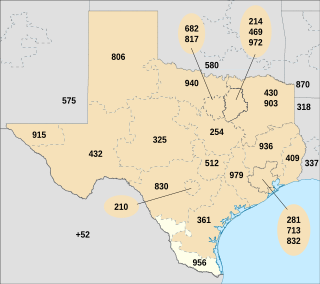
Area code 956 is a telephone area code in the North American Numbering Plan for the Lower and Middle Rio Grande Valley regions in the U.S. state of Texas. The numbering plan area includes the communities of Brownsville, McAllen, Laredo and South Padre Island. The area code was created May 25, 1997, in a split from area code 210.
State Highway 48 runs from Brownsville to Port Isabel in Deep South Texas.

State Highway 186 is a state highway in the Rio Grande Valley in Hidalgo and Willacy counties in Texas, United States, that connects U.S. Route 281 (US 281), future Interstate 69C, and Farm to Market Road 1017 (FM 1017) in Linn with the Gulf of Mexico at Port Mansfield.
Loop 20, also known as the Bob Bullock Loop and Cuatro Vientos Road, is a highway loop that runs to the north and east of the city of Laredo, Texas. Loop 20 extends from the World Trade International Bridge at its northern point to Mangana-Hein Road at its southern point. The current route varies in construction from a 2-lane road to a freeway with frontage roads.
U.S. Highway 83 (US 83), dedicated as the Texas Vietnam Veterans Memorial Highway, is a U.S. Highway in the U.S. state of Texas that begins at US 77 in Brownsville and follows the Rio Grande to Laredo, then heads north through Abilene to the Oklahoma state line north of Perryton, the seat of Ochiltree County.
U.S. Route 281 (US 281) is a United States Numbered Highway that runs from the Mexican border in the Rio Grande Valley to the Canadian border near Dunseith, North Dakota. In the state of Texas, the highway is a major south–north corridor, connecting Brownsville to the Oklahoma state line at the Red River in Burkburnett. Several segments of U.S. 281 are concurrent with Interstate routes, including I-69C in the Rio Grande Valley, I-37 in San Antonio, and I-44 north of Wichita Falls.
U.S. Route 77 (US 77) is a major highway that is part of the United States Numbered Highway System that runs from the Veterans International Bridge in Brownsville to Sioux City, Iowa. In Texas, the road runs south-north for 471.3 miles (758.5 km) from the International border with Mexico to the Oklahoma state line north of Gainesville. The highway is being upgraded to a freeway near Corpus Christi to connect to the freeway part of the highway in Raymondville as part of future I-69. A freeway in Robstown is already signed as part of I-69. From Waco to the Oklahoma state line, US 77 overlaps or runs parallel to I-35/I-35E.
The Ports to Plains Corridor, also known as National Highway System High Priority Corridor 38, is a highway corridor between the United States Mexico border at Laredo, Texas and Denver, Colorado. It is the southern third of the Ports-to-Plains Alliance. The reason for proposed improvements to this corridor is to expedite the transportation of goods and services from Mexico in the United States and vice versa. The proposed improvements gained momentum with the signing of the FY22 Omnibus Appropriations bill, which designated a section of the highway part of the interstate system. The Ports-To-Plains Corridor starts in South Texas and traverses through Texas, New Mexico, Oklahoma, and ends in Denver, Colorado.
Interstate 69 (I-69) is an Interstate Highway that is in the process of being built in the U.S. state of Texas. It is part of a longer I-69 extension known as the NAFTA superhighway, that, when completed, will connect Canada to Mexico. In Texas, it will connect Tenaha and the Louisiana segment of the route through the eastern part of the state and along the Texas Gulf Coast to Victoria, where it will split into three branches: I-69E to Brownsville, I-69C to Pharr, and I-69W to Laredo. The first segment of I-69 in Texas was opened in 2011 near Corpus Christi. The American Association of State Highway and Transportation Officials (AASHTO) approved an additional 58 miles (93 km) of U.S. Highway 77 (US 77) from Brownsville to the Willacy–Kenedy county line for designation as I-69, which was to be signed as I-69E upon concurrence from the Federal Highway Administration (FHWA). FHWA approval for this segment was announced on May 29, 2013. By March 2015, a 74.9-mile (120.5 km) section of US 59 had been completed and designated as I-69 through Greater Houston. As of 2024, short segments near the southern terminuses of the three branch routes have also all been completed. These branches are planned to be connected to the rest of Interstate 69.
Interstate 69C (I-69C) is a north–south Interstate Highway running through South Texas. Once complete, the freeway will begin at I-2/U.S. Highway 83 (US 83) in Pharr and head northward before terminating at I-69W/US 59 in George West near I-37. For its entire length, I-69C is concurrent with US 281. As of 2023, only an 18-mile (29 km) segment has been completed at the route's southern terminus in Pharr.
Interstate 69E (I-69E) is a north–south Interstate Highway running through South Texas. Once complete, the freeway will begin in Brownsville and head northward before terminating near Victoria as both I-69W and I-69E merge into I-69 toward Houston. For its entire length, I-69E runs concurrently with U.S. Highway 77 (US 77). The route currently exists in two segments: a 56.894-mile (91.562 km) segment from its southern terminus in Brownsville to the Willacy–Kenedy county line and a shorter 24.106-mile (38.795 km) segment south of Corpus Christi. The route has one auxiliary Interstate route, I-169 in Brownsville.
Interstate 69W (I-69W) is a relatively short north–south Interstate Highway running through South Texas in the United States. The freeway begins northeast of the middle of the World Trade International Bridge in Laredo and ends at I-35. In the future, I-69W will head northeast for 180 miles (290 km) before terminating near Victoria as both I-69E and I-69W merge to form I-69. For its entire length, I-69W runs concurrently with U.S. Highway 59 (US 59).
Business US Route 83-S is a business loop of US 83 in the Lower Rio Grande Valley region of Texas. The highway serves as the main street for many communities in the area, such as McAllen, Mission, San Juan, Alamo, and more. This is the longest business loop in Texas, traveling almost 47 miles and is the third longest bannered US highway in the state; only US 90 Alternate and US 77 Alternate are longer.
Interstate 169 (I-169) is an auxiliary route of I-69E in Texas that currently runs from I-69E in Brownsville southeast concurrently with State Highway 550 (SH 550), a toll road under construction that connects to the Port of Brownsville for 1.5 miles (2.4 km). When SH 550 is complete, it will be a limited-access toll route around the northern and eastern edges of Brownsville and signed as I-169, partly replacing and expanding Farm to Market Road 511 (FM 511). Its purpose is to provide a new entry point for truck traffic to the Port of Brownsville and forming a loop that allows traffic to bypass the northern sections of the urbanized extent of the Brownsville city limits. This may serve as a relief route for future traffic congestion and as a future business corridor.