Donna, Texas

Last updated

Donna, Texas
Motto: 
"The Heart of the Valley"
TXMap-doton-Donna.PNG
Location of Donna, Texas
Hidalgo County Donna.svg
Coordinates: 26°10′13″N98°2′57″W / 26.17028°N 98.04917°W / 26.17028; -98.04917
Country United States of America
State Texas
County Hidalgo
Area
[1]
  Total8.30 sq mi (21.50 km2)
  Land8.29 sq mi (21.48 km2)
  Water0.01 sq mi (0.03 km2)
Elevation
92 ft (28 m)
Population
 (2020) [2]
  Total16,797
  Density2,000/sq mi (780/km2)
Time zone UTC-6 (Central (CST))
  Summer (DST) UTC-5 (CDT)
ZIP code
78537
Area code 956
FIPS code 48-20884 [3]
GNIS feature ID1334485 [4]
Website cityofdonna.org

Donna is a city in Hidalgo County, Texas, United States. The population was 16,797 at the 2020 census. [2]

Contents

History

Donna is in southeastern Hidalgo County, 11 miles (18 km) east of McAllen, in territory that was granted to Lino Cabazos as part of the La Blanca land grant on May 19, 1834, by the Mexican state of Tamaulipas. The Cabazos family inhabited the area for at least twenty years after taking possession of the land, and their descendants continued to live in the area into the twentieth century. The first known Anglo-American settler was John F. Webber, who, accompanied by his wife Sylvia (Hector), a former slave, settled in the area in 1839. The Webbers moved to the area in order to escape persecution for their interracial marriage. [5]

Donna, Texas was shown in a postcard mailed on November 15, 1916. Donna TX - Nov 15 1916.jpg
Donna, Texas was shown in a postcard mailed on November 15, 1916.

Several families from northern states, including the Ruthven, Champion, and Hooks families, settled the area. Thomas Jefferson Hooks arrived in the Lower Rio Grande valley in 1900 and the following year moved his family to Run in southeastern Hidalgo County. In May 1902 he helped to form the La Blanca Agricultural Company, which purchased 23,000 acres (93 km2) fronting the river 2 miles (3 km) east and west of the site of present Donna and extending north 18 miles (29 km). He gave part of his purchase to his 21-year-old daughter, Donna Hooks Fletcher, a divorcée. [5]

She settled in the area and established the Alameda (Grove) Ranch. Fletcher stocked the ranch with Jersey cattle purchased from the Lassater Ranch in Falfurrias and ran a successful butter business. The Hidalgo and San Miguel Extension (later called the Sam Fordyce Branch) of the St. Louis, Brownsville and Mexico Railway reached the site in July 1904, when the town was founded. In 1907 the town received a depot and was named "Donna" in honor of Donna Fletcher, who was postmistress when the Donna post office opened in 1908. [5]

That year the first store in west Donna was established by Ed Ruthven, and the community was recognized as the Texas station that shipped the most produce in a year. A 500-ton-capacity sugar mill was built in Donna that year. The Donna Developer was first printed on December 1, 1910, in Chapin. That year the Community Church was constructed and shared by the town's Protestant groups. The First Presbyterian Church was founded on July 10, and the First Baptist Church was organized on July 24, 1910. The telephone exchange was installed in 1911. Donna incorporated on April 13, 1911. By 1912 the town was divided into Donna and East Donna. East Donna, the Mexican side of town, had a post office named "Beatriz", after Beatriz Hooks, from 1912 to 1916. Saint Joseph Catholic Church and a school for Mexican children were located there. [5]

A store was moved from Run to Donna in 1914 by Andrew Champion. In 1915 Donna had a population of 1,500, a bank, a hotel, four churches, two cotton gins, the sugar mill, and a weekly newspaper named the Donna Dispatch, published by B. L. Brooks. In 1916 the Donna Light and Power Company was incorporated by A. F. Hester Sr., T. J. Hooks, Dr. J. B. Roberts, and twenty stockholders. The American Legion Hall, Donna Border Post No. 107, was dedicated in 1920. Donna had an estimated population of 1,579 in 1925. By 1936 it had a population of 4,103, a railroad stop, multiple dwellings, and 110 businesses. [5]

The citizens of Donna first started using the motto "The City with a Heart in the Heart of the Rio Grande Valley" to promote the city in the 1940s. By 1945 the town had a population of 4,712 and 78 businesses, and it continued to be a citrus and vegetable growing center. In 1953 Donna had three gins, three wholesale groceries, hardware and farm implements dealers, a wholesale distributor for feed mills, and the Donna News. The election of 1954 drew attention to Donna when Bob Jefferys, a newspaperman, requested that a special contingent of Texas Rangers be sent to the city by Governor Allan Shivers. He alleged that the election campaign was becoming violent because political bosses were physically threatening voters. The American Legion Hall was designated a historical landmark in 1964. In 1967 Donna reported 110 businesses (including eight manufacturers), ten churches, a bank, a library, and a newspaper.

From 1920 through the mid-1960s Donna had segregated schools. A third school for migrant students was in operation through the 1970s. The justification for its operation was that migrant children needed more attention because of their parents' work. It was opened to children in the third to eighth grade and had a separate campus. Donna had a population of 8,982 and 122 businesses in 1978. After the 1970s the economy in Donna continued to be based on fruits, vegetables, and the tourist trade. In 2000 Donna had a population of 14,768 and 369 businesses.

There are five colonias immediately south of the Donna city limits off Farm-to-Market Road 493. Colonia Nueva is on Farm-to-Market Road 493 2 miles (3 km) south of Donna; Colonia Algeria is on River Road and Eleventh Street next to the city dump; Colonia Tierra Prieta is on the east side of Farm-to-Market Road 493; Colonia Salinas is south of Donna; and South Donna is a subdivision. Water is provided to the colonias by Colonia Nueva Water Distribution System, a privately owned enterprise that purchases water from the city of Donna and resells it to 400 colonia domiciles. Tierra Prieta also receives water from North Alamo Water Supply Corporation; it had an estimated population of 180 in 1986.

In 1998 Pablo Lucio Vasquez murdered David Cardenas. [6]

Geography

Donna is located in southern Texas at 26°10′13″N98°2′57″W / 26.17028°N 98.04917°W / 26.17028; -98.04917 (26.170336, –98.049037). [7] It is bordered on the east by the city of Weslaco and on the west by Alamo. The southern boundary of Donna is a few miles north of the Rio Grande, the international border between the United States and Mexico.

Interstate 2/U.S. Highway 83 pass through the northern side of the city, leading west 11 miles (18 km) to McAllen and east 23 miles (37 km) to Harlingen. Via McAllen it is 244 miles (393 km) south of San Antonio. Hooks Avenue is the main road through the center of Donna.

According to the United States Census Bureau, the city has a total area of 8.3 square miles (21.5 km2), of which 0.01 square miles (0.03 km2), or 0.13%, are water. [8]

Climate

The city can be classified as a hot semiarid climate (Köppen: BSh) similar to that found in southwest Texas and northwest Mexico. Donna, according to the climate map and the data used can be considered the easternmost city with a semi-arid climate in the eastern United States, not far from a humid subtropical climate due to the greater proximity of the coast, which probably limits the group B of Köppen further east of the state. [9]

Demographics

Historical population
CensusPop.Note
1920 1,579
1930 4,103159.8%
1940 4,71214.8%
1950 7,17152.2%
1960 7,5224.9%
1970 7,365−2.1%
1980 9,95235.1%
1990 12,65227.1%
2000 14,76816.7%
2010 15,7987.0%
2020 16,7976.3%
U.S. Decennial Census [10] [ failed verification ] 2020 [2]

Donna is part of the McAllen–Edinburg–Mission and Reynosa–McAllen metropolitan areas.

2020 census

Donna racial composition [11]
(NH = Non-Hispanic) [lower-alpha 1]
RaceNumberPercentage
White (NH)1,0576.29%
Black or African American (NH)180.11%
Native American or Alaska Native (NH)140.08%
Asian (NH)110.07%
Pacific Islander (NH)50.03%
Some Other Race (NH)300.18%
Mixed/Multi-Racial (NH)540.32%
Hispanic or Latino 15,60892.92%
Total16,797

As of the 2020 United States census, there were 16,797 people, 4,887 households, and 3,630 families residing in the city.

2000 census

As of the census [3] of 2000, there were 14,768 people, 4,167 households, and 3,525 families residing in the city. The population density was 2,929.5 inhabitants per square mile (1,131.1/km2). There were 5,734 housing units at an average density of 1,137.5 per square mile (439.2/km2). The racial makeup of the city was 76.06% European American, 0.37% African American, 0.60% Native American, 0.18% Asian, 20.40% from other races, and 2.40% from two or more races. Hispanic or Latino of any race were 87.26% of the population.

There were 4,167 households, out of which 43.1% had children under the age of 18 living with them, 60.0% were married couples living together, 20.0% had a female householder with no husband present, and 15.4% were non-families. 13.6% of all households were made up of individuals, and 8.8% had someone living alone who was 65 years of age or older. The average household size was 3.54 and the average family size was 3.91.

In the city, the population was spread out, with 34.1% under the age of 18, 10.7% from 18 to 24, 23.9% from 25 to 44, 17.1% from 45 to 64, and 14.2% who were 65 years of age or older. The median age was 29 years. For every 100 females, there were 92.0 males. For every 100 females age 18 and over, there were 86.2 males.

The median income for a household in the city was $22,800, and the median income for a family was $23,892. Males had a median income of $19,815 versus $17,009 for females. The per capita income for the city is about $10,000. About 32.6% of families and 37.8% of the population were below the poverty line, including 48.1% of those under age 18 and 25.5% of those age 65 or over.

Government

The United States Postal Service operates the Donna Post Office. [14]

Education

The first teacher in Donna was Paciana Guerra of Mier, Tamaulipas, hired in 1911 by Severiano Avila, Apolonio Ballí, and Bentura Bentiz to instruct their children. In 1913, the first graduating class of four graduated from Donna High School. At that time, the Donna school district encompassed all of Weslaco and reached to the Mercedes corporate boundary. [5]

Primary and secondary schools

Donna is served by the Donna Independent School District. In 2010–2012, Donna ISD received an $850,000 Connections Grant from the Texas Education Agency to provide technology staff development, as well as introduce a 1:1 laptop initiative to specific campuses.

Donna ISD currently has 13 elementary schools, four middle schools, and two high schools.

In addition, South Texas Independent School District operates magnet schools that serve the community in the area.

In 1998, IDEA Academy & College Preparatory opened their doors in Donna as a public charter school. IDEA Donna is the flagship of the IDEA Public Schools network that continues to grow and operate throughout the RGV and across the state of Texas. [15]

Public libraries

The Donna Public Library is located in Donna. [16]

Recreation

Media and journalism

Area television stations

Area radio stations

Notes

  1. "2019 U.S. Gazetteer Files". United States Census Bureau. Retrieved August 7, 2020.
  2. 1 2 3 "Quick Facts: Donna city, Texas". census.gov. Retrieved May 23, 2022.
  3. 1 2 "U.S. Census website". United States Census Bureau . Retrieved January 31, 2008.
  4. "US Board on Geographic Names". United States Geological Survey. October 25, 2007. Retrieved January 31, 2008.
  5. 1 2 3 4 5 6 DHF:L&W.
  6. "The Latest: Texas Executes Man for Killing 12-Year-Old Boy." Associated Press. April 6, 2016. Retrieved on April 10, 2016.
  7. "US Gazetteer files: 2010, 2000, and 1990". United States Census Bureau. February 12, 2011. Retrieved April 23, 2011.
  8. "Geographic Identifiers: 2010 Census Summary File 1 (G001): Donna city, Texas". American Factfinder. U.S. Census Bureau. Archived from the original on February 13, 2020. Retrieved February 14, 2018.
  9. "Interactive United States Koppen-Geiger Climate Classification Map". www.plantmaps.com. Retrieved October 21, 2018.
  10. "Census of Population and Housing". Census.gov. Retrieved June 4, 2015.
  11. "Explore Census Data". data.census.gov. Retrieved May 21, 2022.
  12. Bureau, US Census. "Census.gov". Census.gov. Retrieved July 13, 2023.
  13. "About the Hispanic Population and its Origin". www.census.gov. Retrieved May 18, 2022.
  14. "Post Office Location - DONNA Archived June 6, 2012, at the Wayback Machine ." United States Postal Service. Retrieved on May 9, 2010.
  15. "Homepage". IDEA Public Schools. Retrieved July 13, 2023.
  16. "Address Archived 2011-10-05 at the Wayback Machine ." Donna Public Library. Retrieved on May 7, 2010.
  17. "105.5 & 106.3 KISS FM - All The Hits for the Rio Grande Valley". 105.5 & 106.3 KISS FM. Retrieved July 13, 2023.
  1. Note: the US Census treats Hispanic/Latino as an ethnic category. This table excludes Latinos from the racial categories and assigns them to a separate category. Hispanics/Latinos can be of any race. [12] [13]

Related Research Articles

<span class="mw-page-title-main">Harlingen, Texas</span> City in Texas, United States

Harlingen is a city in Cameron County in the central region of the Rio Grande Valley of the southern part of the U.S. state of Texas, about 30 miles (48 km) from the coast of the Gulf of Mexico. The city covers more than 40 square miles (104 km2) and is the second-largest city in Cameron County, as well as the fourth-largest in the Rio Grande Valley. As of the 2020 census, the city had a population of 71,892.

<span class="mw-page-title-main">Starr County, Texas</span> County in Texas, United States

Starr County is located in the U.S. state of Texas. As of the 2020 census, its population was 65,920. Its county seat is Rio Grande City. The county was created in 1848. It is named for James Harper Starr, who served as secretary of the treasury of the Republic of Texas.

<span class="mw-page-title-main">Hidalgo County, Texas</span> County in Texas, United States

Hidalgo County is located in the U.S. state of Texas. The county seat is Edinburg and the largest city is McAllen. The county is named for Miguel Hidalgo y Costilla, the priest who raised the call for Mexico's independence from Spain. It is located in the Rio Grande Valley of South Texas and is one of the fastest-growing counties in the United States. As of the 2020 census, its population was 870,781, making it the ninth-most populous county in Texas, and the most populous county outside of the counties in the Texas Triangle. Hidalgo County is designated by the U.S. Census Bureau as the McAllen–Edinburg–Mission metropolitan statistical area, which itself is part of the McAllen-Edinburg-Mission-Rio Grande City, Texas combined statistical area with neighboring Starr County.

<span class="mw-page-title-main">Alamo, Texas</span> City in Texas

Alamo, located in the Rio Grande Valley in what is nicknamed the "Land of Two Summers", is a city in the irrigated area of southern Hidalgo County, Texas, United States. Known as the "Refuge to the Valley", it is located in an area of abundant vegetable farming and citrus groves, and is a noted winter resort/retirement town near the Mexico–U.S. border. Alamo is one of the Rio Grande Valley's gateways to Mexico, via U.S. Route 281 and Nuevo Progreso, Tamaulipas, as well as a gateway to the Santa Ana National Wildlife Refuge. Alamo's population was 18,353 at the 2010 census and an estimated 19,910 in 2019.

<span class="mw-page-title-main">Edinburg, Texas</span> City in Texas, United States

Edinburg is a city in and the county seat of Hidalgo County, Texas, United States. The population was 100,243 at the 2020 census, and in 2022, its estimated population was 104,294, making it the second-largest city in Hidalgo County, and the third-largest city in the larger Rio Grande Valley region.

<span class="mw-page-title-main">Granjeno, Texas</span> City in Texas, United States

Granjeno is a city in Hidalgo County, Texas, United States. The population was 283 at the 2020 census. The city sits on the banks of the Rio Grande, near the border with Mexico. Its name comes from the granjeno tree or spiny hackberry.

<span class="mw-page-title-main">Hidalgo, Texas</span> City in Texas, United States

Hidalgo is a city in Hidalgo County, Texas, United States. The population was 11,198 at the 2010 census, and in 2019 the estimated population was 14,183.

<span class="mw-page-title-main">McAllen, Texas</span> City in Texas, United States

McAllen is a city in the U.S. state of Texas and the most populous city in Hidalgo County. It is located at the southern tip of the state in the Rio Grande Valley, on the Mexico–United States border. The city limits extend south to the Rio Grande, across from the Mexican city of Reynosa. McAllen is about 70 mi (110 km) west of the Gulf of Mexico. As of the 2020 census, McAllen's population was 142,210, making it the 23rd-most populous city in Texas. It is the fifth-most populous metropolitan area (McAllen–Edinburg–Mission) in the state of Texas, and the binational Reynosa–McAllen metropolitan area counts a population of more than 1.5 million.

<span class="mw-page-title-main">Mercedes, Texas</span> City in Texas, United States

Mercedes is a U.S. city in Hidalgo County, Texas. The population was 15,570 at the 2010 census. It is part of the McAllen–Edinburg–Mission and Reynosa–McAllen metropolitan areas.

<span class="mw-page-title-main">Mission, Texas</span> City in Texas, United States

Mission is a city in Hidalgo County, Texas, United States. The population was 85,778 at the 2020 census and an estimated 86,635 in 2022. Mission is part of the McAllen–Edinburg–Mission and Reynosa–McAllen metropolitan areas.

<span class="mw-page-title-main">Pharr, Texas</span> City in Texas

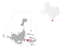
Pharr is a city in Hidalgo County, Texas, United States. As of the 2020 census, the city population was 79,715, and in 2022, the estimated population was 80,187. Pharr is connected by bridge to the Mexican city of Reynosa, Tamaulipas. Pharr is part of the McAllen–Edinburg–Mission and Reynosa–McAllen metropolitan areas.

<span class="mw-page-title-main">Progreso Lakes, Texas</span> City in Texas

Progreso Lakes is a city in Hidalgo County, Texas, United States. The population was 240 at the 2010 United States Census. The city, incorporated in 1979, is centered on Lion and Moon Lakes, two resacas or ox-bow lakes.

<span class="mw-page-title-main">Weslaco, Texas</span> City in Texas, United States

Weslaco is a city in Hidalgo County, Texas, United States. As of the 2020 census the population was 41,103, and in 2020 the estimated population was 41,103. It is located at the southern tip of Texas in the Rio Grande Valley near the Mexican border, across the Rio Grande from the city of Nuevo Progreso, Rio Bravo, Tamaulipas.

<span class="mw-page-title-main">Lower Rio Grande Valley</span> Location in south Texas and Northeast Mexico

The Lower Rio Grande Valley, commonly known as the Rio Grande Valley or locally as the Valley or RGV, is a region spanning the border of Texas and Mexico located in a floodplain of the Rio Grande near its mouth. The region includes the southernmost tip of South Texas and a portion of northern Tamaulipas, Mexico. It consists of the Brownsville, Harlingen, Weslaco, Pharr, McAllen, Edinburg, Mission, San Juan, and Rio Grande City metropolitan areas in the United States and the Matamoros, Río Bravo, and Reynosa metropolitan areas in Mexico. The area is generally bilingual in English and Spanish, with a fair amount of Spanglish due to the region's diverse history and transborder agglomerations. It is home to some of the poorest cities in the nation, as well as many unincorporated, persistent poverty communities called colonias. A large seasonal influx occurs of "winter Texans" — people who come down from the north for the winter and then return north before summer arrives.

<span class="mw-page-title-main">Area code 956</span> Area code in south Texas, United States

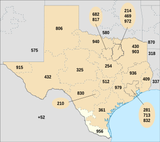
Area code 956 is a telephone area code in the North American Numbering Plan for the Lower and Middle Rio Grande Valley regions in the U.S. state of Texas. The numbering plan area includes the communities of Brownsville, McAllen, Laredo and South Padre Island. The area code was created May 25, 1997, in a split from area code 210.

<span class="mw-page-title-main">Laredo–Nuevo Laredo</span> International transborder agglomeration in southern Texas and northwestern Tamaulipas

Laredo–Nuevo Laredo is one of six transborder agglomerations along the U.S.-Mexican border. The city of Laredo is situated in the U.S. state of Texas on the northern bank of the Rio Grande and Nuevo Laredo is located in the Mexican State of Tamaulipas in the southern bank of the river. This area is also known as the Two Laredos or the Laredo Borderplex. The area is made up of one county in the U.S and three municipalities in Mexico. Two urban areas, three cities, and 12 towns make the Laredo–Nuevo Laredo Metropolitan area. The two sides of the Borderplex are connected by four International Bridges and an International Railway Bridge. The Laredo–Nuevo Laredo Metropolitan area has a total of 636,516 inhabitants according to the INEGI Census of 2010 and the United States Census estimate of 2010. According to World Gazetteer this urban agglomeration ranked 157th largest in North and South America in 2010 with an estimated population of 675,481. This area ranks 66th in the United States and 23rd in Mexico.

<span class="mw-page-title-main">KRIO (AM)</span> Radio station in McAllen, Texas

KRIO is a radio station broadcasting a Spanish-language Christian radio format. Licensed to McAllen, Texas, US, the station serves the McAllen-Brownsville-Harlingen area. The station is currently owned by Rio Grande Bible Institute, Inc.

<span class="mw-page-title-main">Reynosa–McAllen</span> International transborder agglomeration in southern Texas and northern Tamaulipas

Reynosa–McAllen, also known as McAllen–Reynosa, or simply as Borderplex, is one of the six international conurbations along the Mexico–U.S border. The city of Reynosa is situated in the Mexican state of Tamaulipas, on the southern bank of the Rio Grande, while the city of McAllen is located in the American state of Texas, directly north across the bank of the Rio Grande. This area has a population of roughly 1,500,000, making it the largest and most populous in the state of Tamaulipas, and third most populous on the US–Mexico border.

Las Milpas is a community in the City of Pharr, in central Hidalgo County, Texas in the Rio Grande Valley. It was previously an unincorporated area. Las Milpas, a colonia, is located off of U.S. Highway 281, 5 miles (8.0 km) south of the city center of Pharr, and between McAllen and the United States-Mexico border.

XELD-TV was a television station located in Matamoros, Tamaulipas, Mexico, whose over-the-air signal also covered the Rio Grande Valley across the international border in the United States. The station broadcast in English and Spanish from September 15, 1951, to April 29, 1954.

References