Doffing, Texas

Last updated • 2 min readFrom Wikipedia, The Free Encyclopedia

Doffing, Texas
Hidalgo County Doffing.svg
Coordinates: 26°16′23″N98°23′5″W / 26.27306°N 98.38472°W / 26.27306; -98.38472
Country Flag of the United States.svg  United States of America
State Flag of Texas.svg  Texas
County Flag of Hidalgo County, Texas.png Hidalgo
Area
  Total4.3 sq mi (11.2 km2)
  Land4.3 sq mi (11.2 km2)
  Water0.0 sq mi (0.0 km2)
Elevation
194 ft (59 m)
Population
 (2020)
  Total5,618
  Density1,300/sq mi (500/km2)
Time zone UTC-6 (Central (CST))
  Summer (DST) UTC-5 (CDT)
ZIP code
78574 [1]
FIPS code 48-20734 [2]
GNIS feature ID1852698 [3]

Doffing is a census-designated place (CDP) in Hidalgo County, Texas, United States. The population was 5,091 at the 2010 United States Census. It is part of the McAllen Edinburg Mission Metropolitan Statistical Area.

Contents

Geography

Doffing is located at 26°16′23″N98°23′5″W / 26.27306°N 98.38472°W / 26.27306; -98.38472 (26.273076, -98.384741). [4]

According to the United States Census Bureau, the CDP has a total area of 4.3 square miles (11 km2), all land.

Demographics

Historical population
CensusPop.Note
2000 4,256
2010 5,09119.6%
2020 5,61810.4%
U.S. Decennial Census [5]
1850–1900 [6] 1910 [7]
1920 [8] 1930 [9] 1940 [10]
1950 [11] 1960 [12] 1970 [13]
1980 [14] 1990 [15] 2000 [16]
2010 [17] 2020 [18]

Doffing first appeared as a census designated place in the 2000 U.S. Census. [16]

2020 census

Doffing CDP, Texas – Racial and ethnic composition
Note: the US Census treats Hispanic/Latino as an ethnic category. This table excludes Latinos from the racial categories and assigns them to a separate category. Hispanics/Latinos may be of any race.
Race / Ethnicity (NH = Non-Hispanic)Pop 2000 [19] Pop 2010 [20] Pop 2020 [21] % 2000% 2010% 2020
White alone (NH)34172490.80%3.38%0.87%
Black or African American alone (NH)0350.00%0.06%0.09%
Native American or Alaska Native alone (NH)0700.00%0.14%0.00%
Asian alone (NH)0100.00%0.02%0.00%
Pacific Islander alone (NH)0000.00%0.00%0.00%
Some Other Race alone (NH)00120.00%0.00%0.21%
Mixed race or Multiracial (NH)0190.00%0.02%0.16%
Hispanic or Latino (any race)4,2224,9075,54399.20%96.39%98.67%
Total4,2565,0915,618100.00%100.00%100.00%

As of the census [2] of 2000, there were 4,256 people, 915 households, and 871 families residing in the CDP. The population density was 982.0 inhabitants per square mile (379.2/km2). There were 1,024 housing units at an average density of 236.3 per square mile (91.2/km2). The racial makeup of the CDP was 34.35% White, 0.02% African American, 64.92% from other races, and 0.70% from two or more races. Hispanic or Latino of any race were 99.20% of the population.

There were 915 households, out of which 75.7% had children under the age of 18 living with them, 79.9% were married couples living together, 11.8% had a female householder with no husband present, and 4.8% were non-families. 4.3% of all households were made up of individuals, and 1.3% had someone living alone who was 65 years of age or older. The average household size was 4.65 and the average family size was 4.74.

In the CDP, the population was spread out, with 45.7% under the age of 18, 10.7% from 18 to 24, 30.4% from 25 to 44, 10.9% from 45 to 64, and 2.4% who were 65 years of age or older. The median age was 20 years. For every 100 females, there were 96.9 males. For every 100 females age 18 and over, there were 95.2 males.

The median income for a household in the CDP was $18,192, and the median income for a family was $19,353. Males had a median income of $15,017 versus $12,784 for females. The per capita income for the CDP was $4,923. About 43.0% of families and 42.5% of the population were below the poverty line, including 48.5% of those under age 18 and 26.8% of those age 65 or over.

Education

Doffing is served by the La Joya Independent School District. Zoned schools include: [22] [23]

In addition, South Texas Independent School District operates magnet schools that serve the community.

Related Research Articles

<span class="mw-page-title-main">Canyon Lake, Texas</span> CDP in Texas, United States

Canyon Lake is a census-designated place (CDP) in Comal County, Texas, United States. The population was 31,124 at the 2020 census. It is part of the San Antonio Metropolitan Statistical Area.

<span class="mw-page-title-main">Abram-Perezville, Texas</span> Former census-designated place in Texas

Abram-Perezville is a former census-designated place (CDP) in Hidalgo County, Texas. The population was 5,376 at the 2010 United States Census. It is part of the McAllen–Edinburg–Mission Metropolitan Statistical Area. For the 2010 census, the CDP was split into Abram and Perezville.

<span class="mw-page-title-main">Citrus City, Texas</span> Census-designated place in Texas

Citrus City is a census-designated place (CDP) in Hidalgo County, Texas, United States. The population was 3,291 at the 2020 census. It is part of the McAllen–Edinburg–Mission Metropolitan Statistical Area. The town was founded in 1943 during World War II by Howard Moffitt, a builder known for his vernacular Moffitt cottage architectural style, as part of a planned regional orange and grapefruit growing community. The local irrigation system proved to be too saline for fruit production, and the plans for a large town were revised. A few Moffitt houses survive in Citrus City.

<span class="mw-page-title-main">Cuevitas, Texas</span> Census-designated place in Texas

Cuevitas is a census-designated place (CDP) in Hidalgo County, Texas, United States. The population was 40 at the 2010 United States Census. Rated the poorest community in Texas, it is part of the McAllen–Edinburg–Mission Metropolitan Statistical Area.

<span class="mw-page-title-main">Doolittle, Texas</span> Census-designated place in Texas

Doolittle is a census-designated place (CDP) in Hidalgo County, Texas, United States. The population was 4,061 at the 2020 United States Census. It is part of the McAllen–Edinburg–Mission Metropolitan Statistical Area.

<span class="mw-page-title-main">Havana, Texas</span> Census-designated place in Texas

Havana is a census-designated place (CDP) in Hidalgo County, Texas, United States. The population was 361 at the 2020 United States Census. It is part of the McAllen–Edinburg–Mission Metropolitan Statistical Area.

<span class="mw-page-title-main">La Homa, Texas</span> Census-designated place in Texas

La Homa is a census-designated place (CDP) in Hidalgo County, Texas, United States. The population was 11,267 at the 2020 United States Census. It is part of the McAllen–Edinburg–Mission Metropolitan Statistical Area.

<span class="mw-page-title-main">Lopezville, Texas</span> Census-designated place in Texas

Lopezville is a census-designated place (CDP) in Hidalgo County, Texas, United States. The population was 2,367 at the 2020 United States Census. It is part of the McAllen–Edinburg–Mission Metropolitan Statistical Area. The town developed during the early 1960s as a trailer park. It is named for Francisco Solano López, a former president of Paraguay, a descendant of whom founded his namesake trailer park.

<span class="mw-page-title-main">Los Ebanos, Hidalgo County, Texas</span> Census-designated place in Texas

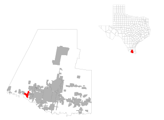
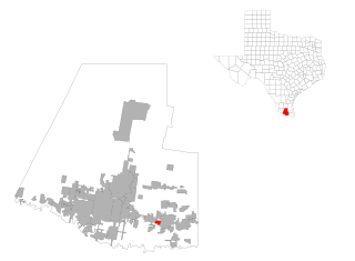
Los Ebanos is a census-designated place (CDP) in Hidalgo County, Texas, United States. The population was 239 at the 2020 United States Census. It is part of the McAllen–Edinburg–Mission Metropolitan Statistical Area. The city is named after the Texas Ebony that anchors the Los Ebanos Ferry.

<span class="mw-page-title-main">Midway North, Texas</span> Census-designated place in Texas

Midway North is a census-designated place (CDP) in Hidalgo County, Texas, United States. The population was 4,232 at the 2020 United States Census. It is part of the McAllen–Edinburg–Mission Metropolitan Statistical Area.

<span class="mw-page-title-main">Midway South, Texas</span> Census-designated place in Texas

Midway South is a census-designated place (CDP) in Hidalgo County, Texas, United States. The population was 2,307 at the 2020 United States Census. It is part of the McAllen–Edinburg–Mission Metropolitan Statistical Area.

<span class="mw-page-title-main">North Alamo, Texas</span> Census-designated place in Texas, United States

North Alamo is a census-designated place (CDP) in Hidalgo County, Texas, United States. The population was 3,722 at the 2020 United States Census. It is part of the McAllen–Edinburg–Mission Metropolitan Statistical Area.

<span class="mw-page-title-main">Murillo, Texas</span> Census-designated place in Texas

Murillo, previously recorded as Nurillo, is a census-designated place (CDP) in Hidalgo County, Texas, United States. The population was 9,158 at the 2020 census. It is part of the McAllen–Edinburg–Mission Metropolitan Statistical Area.

<span class="mw-page-title-main">Palmview South, Texas</span> Census-designated place in Texas

Palmview South is a census-designated place (CDP) in Hidalgo County, Texas, United States. The population was 2,008 at the 2020 United States Census. It is part of the McAllen–Edinburg–Mission Metropolitan Statistical Area.

<span class="mw-page-title-main">San Carlos, Texas</span> Census-designated place in Texas

San Carlos is a community and census-designated place (CDP) in Hidalgo County, Texas. The population was 3,087 at the 2020 United States Census. It is part of the McAllen–Edinburg–Mission Metropolitan Statistical Area.

<span class="mw-page-title-main">Sullivan City, Texas</span> City in Texas

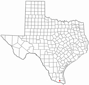
Sullivan City is a city in Hidalgo County, Texas, United States. The population was 3,908 at the 2020 United States Census. It is part of the McAllen–Edinburg–Mission and Reynosa–McAllen metropolitan areas.

<span class="mw-page-title-main">West Sharyland, Texas</span> Census-designated place in Texas

West Sharyland is a census-designated place (CDP) in Hidalgo County, Texas, United States. The population was 2,004 at the 2020 United States Census. It is part of the McAllen–Edinburg–Mission Metropolitan Statistical Area.

<span class="mw-page-title-main">Garceno, Texas</span> Census-designated place in Starr County, Texas, United States

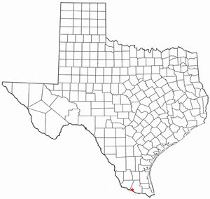
Garceno is a census-designated place (CDP) in Starr County, Texas, United States. The population was 440 at the 2020 census, an increase from the figure of 420 tabulated in 2010.

<span class="mw-page-title-main">Los Alvarez, Texas</span> CDP in Texas, United States

Los Alvarez is a census-designated place (CDP) in Starr County, Texas, United States. The population was 303 at the 2010 census, a decline from the figure of 1,434 tabulated in 2000.

<span class="mw-page-title-main">North Escobares, Texas</span> CDP in Texas, United States

North Escobares is a census-designated place (CDP) in Starr County, Texas, United States. The population was 162 at the 2020 census.

References

  1. "Doffing ZIP Code". zipdatamaps.com. 2023. Retrieved January 12, 2023.
  2. 1 2 "U.S. Census website". United States Census Bureau . Retrieved January 31, 2008.
  3. "US Board on Geographic Names". United States Geological Survey. October 25, 2007. Retrieved January 31, 2008.
  4. "US Gazetteer files: 2010, 2000, and 1990". United States Census Bureau. February 12, 2011. Retrieved April 23, 2011.
  5. "Decennial Census by Decade". United States Census Bureau .
  6. "1900 Census of Population - Population of Texas By Counties And Minor Civil Divisions" (PDF). United States Census Bureau .
  7. "1910 Census of Population - Supplement for Texas" (PDF). United States Census Bureau .
  8. "1920 Census of Population - Number of Inhabitants - Texas" (PDF). United States Census Bureau .
  9. "1930 Census of Population - Number of Inhabitants - Texas" (PDF). United States Census Bureau .
  10. "1940 Census of Population - Number of Inhabitants - Texas" (PDF). United States Census Bureau .
  11. "1950 Census of Population - Number of Inhabitants - Texas" (PDF). United States Census Bureau .
  12. "1960 Census of Population - Number of Inhabitants - Texas" (PDF). United States Census Bureau .
  13. "1970 Census of Population - Number of Inhabitants - Texas" (PDF). United States Census Bureau .
  14. "1980 Census of Population - Number of Inhabitants - Texas" (PDF). United States Census Bureau .
  15. "1990 Census of Population - Population and Housing Unit Counts - Texas" (PDF). United States Census Bureau .
  16. 1 2 "2000 Census of Population - Population and Housing Unit Counts - Texas" (PDF). United States Census Bureau .
  17. "2010 Census of Population - Population and Housing Unit Counts - Texas" (PDF). United States Census Bureau .
  18. "Census Bureau profile: Doffing, Texas". United States Census Bureau. May 2023. Retrieved May 17, 2024.
  19. "P004: Hispanic or Latino, and Not Hispanic or Latino by Race – 2000: DEC Summary File 1 – Doffing CDP, Texas". United States Census Bureau.
  20. "P2: Hispanic or Latino, and Not Hispanic or Latino by Race – 2010: DEC Redistricting Data (PL 94-171) – Doffing CDP, Texas". United States Census Bureau.
  21. "P2: Hispanic or Latino, and Not Hispanic or Latino by Race – 2020: DEC Redistricting Data (PL 94-171) – Doffing CDP, Texas". United States Census Bureau.
  22. "2010 CENSUS - CENSUS BLOCK MAP: Doffing CDP, TX." U.S. Census Bureau. Retrieved on September 16, 2018. Pages: 1 and 2
  23. "SCHOOL DISTRICT REFERENCE MAP (2010 CENSUS): Hidalgo County, TX." U.S. Census Bureau. Retrieved on August 2, 2018.
  24. "Elementary School Zones 2017-2018 Archived 2018-09-16 at archive.today ." La Joya Independent School District. Retrieved on September 16, 2018.
  25. "Middle School Zones 2017-2018 Archived 2018-09-16 at archive.today ." La Joya Independent School District. Retrieved on September 16, 2018.
  26. "High School Zones 2017-2018 Archived 2018-09-16 at archive.today ." La Joya Independent School District. Retrieved on September 16, 2018.