List of auxiliary Interstate Highways

Last updated

Dwight D. Eisenhower National System of Interstate and Defense Highways

I-295.svg

Highway shield for Interstate 295
Map of current Interstates.svg
Interstate Highways in the 48 contiguous states
System information
FormedJune 29, 1956 [1]
Highway names
Interstates Interstate X (I-X)
System links

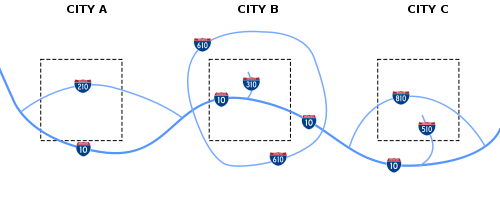
Auxiliary Interstate Highways (also called three-digit Interstate Highways) are a subset of highways within the United States' Interstate Highway System. The 323 auxiliary routes generally fall into three types: spur routes, which connect to or intersect the parent route at one end; bypasses, which connect to the parent route at both ends; and beltways, which form a circle that intersects the parent route at two locations. Some routes connect to the parent route at one end but to another route at the other end; some states treat these as spurs while others treat them as bypasses. Like the primary Interstate Highways, auxiliary highways meet Interstate Highway standards (with rare exceptions).

Contents

The shorter auxiliary routes branch from primary routes; their numbers are based on the parent route's number. All of the supplement routes for Interstate 95 (I-95) are designated with a three-digit number ending in "95": I-x95. With some exceptions, spur routes are numbered with an odd hundreds digit (such as I-395), while bypasses and beltways are numbered with an even hundreds digit (such as I-695). Because longer Interstates may have many such supplemental routes, the numbers can repeat from state to state along their route, but they will not repeat within a state.

There are three states that have no auxiliary Interstate Highways: Alaska, Arizona, and New Mexico. North Dakota has an auxiliary route, but it is unsigned, and Wyoming's does not meet Interstate Highway standards.

Terminology and guidelines

Routes that begin with an even number generally connect to the main highway in two locations, while odd numbers only connect in one location. FHWA Auxiliary Route Numbering Diagram.svg
Routes that begin with an even number generally connect to the main highway in two locations, while odd numbers only connect in one location.

Auxiliary Interstates are divided into three types: spur, loop, and bypass routes.

The first digit of the three digits usually signifies whether a route is a bypass, spur, or beltway. The last two digits are derived from the main Interstate Highway. For instance, I-515 contains an odd number in the first digit (5), which indicates that this freeway is a spur. The last two digits signify the highway's origin. In this case, the "15" in I-515 shows that it is a supplement to I-15.

Exceptions to the standard numbering guidelines exist for a number of reasons. In some cases, original routes were changed, extended, or abandoned, leaving discrepancies in the system. In other cases, it may not be possible to use the proper number because the limited set of available numbers has been exhausted, causing a "non-standard" number to be used.

Spur route

A spur route's number usually has an odd number for its first digit. [2] It is usually one of the following:

Examples include:

Sometimes, a three-digit Interstate Highway branches off from another three-digit Interstate Highway. These spurs do not connect directly with their parent highways, but are associated with them via the three-digit highways they do intersect with.

Examples include:

Bypass

A bypass route may traverse around a city, or may run through it with the mainline bypassing. In a typical 3-digit Interstate Highway, bypasses usually have both its two termini junctioned with another Interstate highway. Bypass routes are preceded by an even number in the first digit. [2]

Examples include:

In the case of an auxiliary Interstate highway which has both ends at Interstates but not the same Interstate, some states treat these as bypasses while others treat these as spurs—see Spur route above.

Beltway

A beltway (also known as a loop route) completely surrounds a metropolitan city, and it is often connected with multiple junctions to other routes. Unlike other auxiliary Interstate Highways (and by extension, all primary Interstate Highways), beltways do not have termini; however, they have a place where the highway mileage resets to zero. Beltways are also preceded by an even number in the first digit. [2]

Some examples of beltways include:

Auxiliary Interstates

Note: this table sorts the route numbers by parent highway.
NumberLength (mi) [3] Length (km)Southern or western terminusNorthern or eastern terminusFormedRemovedNotes
I-H201.svg H-201 4.106.60 H-1 in Halawa, HI H-1 in Honolulu, HI 02004-01-012004 [4] currentSigned as Route 78 until 2004
I-105 (1961).svg I-105 17.3227.87 SR 1 in El Segundo, CA I-605 in Norwalk, CA 01963-01-011963currentReplaced segments of SR 42
I-205 (1961).svg I-205 12.9720.87 I-580 near Tracy, CA I-5 near Tracy, CA01970-01-011970current
I-305 (1961).svg I-305 6.009.66 I-80 in West Sacramento, CA I-80 Bus/US 50/SR 99 in Sacramento, CA 01981-01-011981currentUnsigned
I-405 (1961).svg I-405 72.15116.11 I-5 in Irvine, CA I-5 in Mission Hills, CA 01964-01-011964current
I-505 (1961).svg I-505 32.9853.08 I-80 in Vacaville, CA I-5 in Dunnigan, CA 01977-01-011977currentOriginally part of I-5W
I-605 (1961).svg I-605 27.4044.10 I-405 in Seal Beach, CA I-210 in Irwindale, CA 01964-01-011964current
I-805 (1961).svg I-805 28.0245.09 I-5 in San Ysidro, CA I-5 in Sorrento Valley, CA 01959-01-011959current
I-905 (1961).svg I-905 8.96 [5] 14.42 I-5 in San Ysidro, CA Fed. 2 at the United States-Mexico border in Otay Mesa, CA proposedCurrently SR 905, proposed to be signed as an Interstate
I-105.svg I-105 3.495.62 OR 99 in Eugene, OR I-5 in Springfield, OR 01958-01-011958current
I-305.svg I-305 Pine Street in Salem, OR I-5 in Keizer, OR 01957-01-01195701976-01-011976Canceled
I-405.svg I-405 3.535.68 I-5 in Portland, OR I-5 in Portland, OR01958-01-011958current
I-505.svg I-505 3.175.10 US 30 in Portland, OR I-405 in Portland, OR01969-01-01196901979-01-011979Canceled
I-205.svg I-205 36.6458.97 I-5 in Tualatin, OR I-5 in Salmon Creek, WA 01958-01-011958current
I-405.svg I-405 30.3048.76 I-5/SR 518 in Tukwila, WA I-5/SR 525 in Lynnwood, WA 01957-01-011957current
I-605.svg I-605 WA 99 in Federal Way, WA I-5 in Everett, WA Never built, was planned to bypass Seattle, WA
I-705.svg I-705 1.502.41 I-5/SR 7 in Tacoma, WA Schuster Parkway in Tacoma01978-01-011978current
I-210.svg I-210 4.97.9 I-10 in Mobile, AL I-65 in Prichard, AL Currently I-165, the route number was decommissioned because it had no connection to I-10
I-410.svg I-410 I-10/I-17 in Phoenix, AZ I-10 in Phoenix, AZNow part of I-10 in Phoenix, AZ
I-510.svg I-510 I-10/SR 51 in Phoenix, AZ SR 101 in Phoenix, AZCurrently designated as SR 51 (Piestewa Freeway)
I-710.svg I-710 I-10 in Tucson, AZ North Campbell Avenue/East 6th Street in Tucson, AZMostly never built freeway that was to connect to University of Arizona campus from I-10
I-110 (1961).svg I-110 20.4332.88 SR 47 in San Pedro, CA I-10/SR 110 in Los Angeles, CA 01978-01-011978currentOriginally part of US 6, then signed as SR 11
I-210 (1961).svg I-210 48.7278.41 I-5 in Sylmar, CA SR 57/SR 210 in Glendora, CA 01964-01-011964currentDoes not connect physically with I-10 as segment from SR 57 east to I-10 is still signed as SR 210, formerly SR 30 prior to 2007.
I-710 (1961).svg I-710 19.6631.64 Terminal Island in Long Beach, CA Valley Boulevard in Alhambra, CA 01983-01-011983currentOriginally signed as SR 7
I-110.svg I-110 6.9411.17 US 98 Bus. near Pensacola, FL I-10 near Pensacola, FL01969-01-011969current
I-110.svg I-110 8.8914.31 I-10 in Baton Rouge, LA US 61 in Baton Rouge, LA01964-01-011964current
I-210.svg I-210 12.4019.96 I-10 west of Lake Charles, LA I-10 east of Lake Charles, LA01964-01-011964current
I-310.svg I-310 11.2518.11 US 90/LA 3127 in Boutte, LA I-10 west of Kenner, LA 01983-01-011983current
I-310.svg I-310 2.704.35 US 90 Bus. in New Orleans, LA I-10 in New Orleans, LA01964-01-01196401969-01-011969Canceled Vieux Carré Riverfront Expressway
I-410.svg I-410 1.903.06 LA 67 in Baton Rouge, LA I-10 in Baton Rouge, LA01961-01-01196101964-01-011964Renumbered as I-110
I-410.svg I-410 48.578.1 I-10 west of New Orleans, LA I-10 in New Orleans, LA01969-01-01196901977-01-011977Canceled southern bypass of New Orleans; completed portions became I-310 and I-510
I-510.svg I-510 3.044.89 LA 47 in New Orleans, LA I-10/LA 47 in New Orleans, LA01992-01-011992current
I-610.svg I-610 4.527.27 I-10 at MetairieNew Orleans, LA lineI-10 in New Orleans, LA01965-01-011965current
I-910.svg I-910 9.7015.61 US 90 Bus. in Marrero, LA I-10/US 90 Bus. in New Orleans, LA 01999-01-011999currentUnsigned; completely concurrent with US 90 Bus.; both designation are temporary placeholders for Future I-49
I-110.svg I-110 4.106.60 US 90 in Biloxi, MS I-10 in D'Iberville, MS 01988-01-011988current
I-310.svg I-310 US 90 near the Port of Gulfport, MS I-10 in Gulfport, MSproposedFuture spur into Gulfport, MS
I-110.svg I-110 0.921.48Av Abraham Lincoln at the United States-Mexico border in El Paso, TX I-10 in El Paso, TX01967-01-011967current
I-410.svg I-410 49.4979.65Beltway around San Antonio, TX 01959-01-011959current
I-610.svg I-610 37.9761.11Beltway around Houston, TX 01975-01-011975current
I-215 (1961).svg I-215 54.5087.71 I-15 in Murrieta, CA I-15 in Devore, CA 01982-01-011982currentOriginally signed as I-15E, then SR 215
I-115.svg I-115 1.191.92 I-15/I-90 in Butte, MT Iron Street in Butte, MT01971-01-011971current
I-315.svg I-315 0.831.34 I-15 in Great Falls, MT I-15 Bus/US 89 in Great Falls, MT01960-04-171960currentUnsigned
I-215.svg I-215 11.1017.86 I-15/Clark County Route 215 in Enterprise, NV I-515/US 93/SR 564 in Henderson, NV 01996-01-011996current
I-515.svg I-515 20.5433.06 I-215/I-11/US 93/US 95 in Henderson, NV I-15/US 93/US 95 in Las Vegas, NV 01976-01-011976currentNot signed until 1994, this route is entirely concurrent with US 93/US 95; will be decommisioned and replaced by a northward extension of I-11 in 2024
I-215.svg I-215 29.0246.70 I-80 in Salt Lake City, UT I-15 in North Salt Lake, UT 01963-01-011963current
I-415.svg I-415 2.393.85 I-80 in Salt Lake City, UT 4430 S in Holladay, UT 01965-01-01196501969-01-011969Designation was scrapped to provide a single route number 215 for the entire route.
I-516.svg I-516 6.4910.44 SR 21/SR 204 in Savannah, GA SR 21 in Garden City, GA 01985-01-011985current
I-420.svg I-420 5.408.69 I-285 in College Park, GA I-20 in Atlanta, GA 01983-01-01198301986-01-011986Never built, was planned to bypass Atlanta, GA
I-520.svg I-520 23.3437.56 I-20 in Augusta, GA I-20 in North Augusta, SC 01980-01-011980current
I-220.svg I-220 17.6228.36 I-20/LA 3132 in Shreveport, LA I-20 in Bossier City, LA 01979-01-011979current
I-420.svg I-420 10.2016.42 I-20 in West Monroe, LA I-20 in Monroe, LA 01957-01-01195701964-01-011964Canceled bypass of Monroe
I-220.svg I-220 12.0119.33 I-20 in Jackson, MS I-55 in Ridgeland, MS 01981-01-011981current
I-820.svg I-820 35.1756.60 I-20 in Fort Worth, TX I-20/US 287 in Fort Worth, TX01959-01-011959current
I-222.svg I-222 I-22 in Graysville, AL I-422 in Brookside, AL proposedProposed connector between I-422 and I-22 due to the inability to make a direct connection between the two routes.
I-422.svg I-422 I-20/I-59/I-459/US 11 in Bessemer, AL I-59 in Argo, AL proposedCurrently under construction; will only be indirectly connected to I-22 via I-222.
I-124.svg I-124 1.973.17 I-24 in Chattanooga, TN US 27 in Chattanooga, TN01960-01-011960currentUnsigned
I-225.svg I-225 12.0019.31 I-25 in Denver, CO I-70 in Aurora, CO 01976-01-011976current
I-425.svg I-425 5.318.55 I-25/US 36 at Welby, CO I-70/US 36 at Denver, CO 01959-01-011959Renumbered as I-270 by AASHTO
I-126.svg I-126 3.685.92 I-26 in Columbia, SC US 21/US 76/US 176/US 321 in Columbia, SC01961-01-011961current
I-326.svg I-326 5.248.43 I-26 in Cayce, SC SC 48 in Columbia, SC 01976-01-01197601995-01-011995Now part of I-77, formerly unsigned
I-526.svg I-526 19.2631.00 US 17 in Charleston, SC I-526 Bus./US 17 in Mount Pleasant, SC 01989-01-011989current
I-129.svg I-129 3.485.60 US 20/US 75/US 77 in South Sioux City, NE I-29/US 20/US 75 in Sioux City, IA 01976-01-011976current
I-229.svg I-229 14.9724.09 I-29 in St. Joseph, MO I-29/US 59/US 71 in St. Joseph, MO01986-01-011986current
I-229.svg I-229 11.3318.23 I-29 in Sioux Falls, SD I-90 near Sioux Falls, SD01966-01-011966current
I-130.svg I-130 58.0 I-30/I-49 in Texarkana, AR US 59/US 71 near Texarkana, AR02000-01-01200002014-01-012014Was given a future designation during its existence due to not being upgraded to Interstate Highway standards; freeway became part of I-49 once completed
I-430.svg I-430 12.9320.81 I-30/US 67 in Little Rock, AR I-40/US 65 in Little Rock, AR01980-01-011980current
I-530.svg I-530 46.6575.08 US 65 in Pine Bluff, AR I-30/I-440 in Little Rock, AR 01999-01-011999current
I-630.svg I-630 7.4011.91 I-430 near Little Rock, AR I-30 in Little Rock, AR01985-01-011985current
I-235.svg I-235 13.7822.18 I-35/I-80 in West Des Moines, IA I-35/I-80 near Des Moines, IA 01961-01-011961current
I-135.svg I-135 95.74154.08 Kansas Turnpike/I-35 in Wichita, KS I-70/US 81 in Salina, KS 01976-01-011976current
I-235.svg I-235 16.5226.59 I-135/US 81 in Wichita, KS I-135/US 81/K-15/K-254 in Wichita, KS01965-01-011965current
I-335.svg I-335 50.1380.68 I-35/Kansas Turnpike/US 50 in Emporia, KS I-470/Kansas Turnpike in Topeka, KS 01987-01-011987current
I-435.svg I-435 80.81130.05Beltway around Kansas City, KS, and Kansas City, MO 01965-01-011965current
I-635.svg I-635 8.9014.32 I-35 in Overland Park, KS I-29/US 71 in Kansas City, MO 01968-01-011968current
I-335.svg I-335 2.74 [6] 4.41 I-94 in Minneapolis, MN I-35W in Minneapolis, MN01964-01-01196401978-01-011978Canceled
I-535.svg I-535 2.784.47 I-35/US 53 in Duluth, MN US 53/WIS 35 in Superior, WI 01971-01-011971current
I-235 (long).svg I-235 5.368.63 I-35/I-40 in Oklahoma City, OK I-44 in Oklahoma City, OK01989-01-011989current
I-335 (long).svg I-335 19.631.5SE 89th Street in Oklahoma City, OK I-44 in Luther, OK proposedRouted along the Kickapoo Turnpike [7]
I-635.svg I-635 37.0059.55 SH 121 in Grapevine, TX I-20 in Balch Springs, TX 01959-01-011959current
I-440.svg I-440 9.9616.03 I-30/I-530 near Little Rock, AR I-40/AR 440 near Little Rock, AR02003-01-012003current
I-540.svg I-540 15.8725.54 US 271/AR 253 near Fort Smith, AR I-40 in Van Buren, AR 01965-01-011965current
I-140.svg I-140 6.7910.93 US 17 near Winnabow, NC I-40/US 17 in Wilmington, NC 02008-01-012008current
I-240.svg I-240 9.5415.35 I-26/I-40/US 74 near Asheville, NC I-40/US 74A in Asheville, NC01980-01-011980current
I-440.svg I-440 16.7726.99 I-40/US 1/US 64 near Cary, NC I-40 near Raleigh, NC 01991-01-011991current
I-540.svg I-540 25.8441.59 I-40 near Durham, NC I-87/US 64/US 264 near Knightdale, NC 01997-01-011997current
I-840.svg I-840 21.935.2 I-40/I-73/US 421 in Greensboro, NC I-40/I-85/I-785/I-85 Bus. in Greensboro, NC02011-01-012011current
I-240 (long).svg I-240 16.2226.10I-44/US 62 in Oklahoma City, OK I-40/US 270 in Oklahoma City, OK01965-01-011965current
I-440 (long).svg I-440 9.9616.03 I-40/I-240 near Oklahoma City, OK I-35 in Oklahoma City, OK01975-01-011975Now part of I-44
I-140.svg I-140 11.1717.98 I-40 near Farragut, TN US 129 near Alcoa, TN 01987-01-011987current
I-240.svg I-240 19.2731.01 I-40 in Memphis, TN I-40 in Memphis, TN01970-01-011970current
I-440.svg I-440 7.6412.30 I-40 in Nashville, TN I-24 in Nashville, TN01987-01-011987current
I-640.svg I-640 7.0311.31 I-40 in Knoxville, TN I-40 in Knoxville, TN01982-01-011982current
I-840.svg I-840 77.28 [8] 124.37 I-40 near Dickson, TN I-40 near Lebanon, TN 02016-01-012016currentOriginally designated SR 840 until completion
I-244.svg I-244 2032 I-270/I-55 in Mehlville, MO I-270/I-70 in Bridgeton, MO Redesginated as I-270 in the late-1970s for consistency along the St. Louis Beltway
I-244 (long).svg I-244 15.7525.35 I-44 in Tulsa, OK I-44 in Tulsa, OK01970-01-011970current
I-344 (long).svg I-344 29.447.3 I-240 in Oklahoma City, OK I-35 and I-44/Turner Turnpike in Oklahoma City, OKproposedRouted along the John Kilpatrick Turnpike [7]
I-444 (long).svg I-444 2.514.04 I-244 in Tulsa, OK I-244 in Tulsa, OK01970-01-011970currentUnsigned
I-345.svg I-345 1.402.25 I-30/I-45 in Dallas, TX US 75 in Dallas, TX01973-01-011973currentUnsigned
I-555.svg I-555 49.8080.15 I-55 in Turrell, AR AR 91 in Jonesboro, AR 02016-01-012016current
I-155.svg I-155 32.1351.71 I-55 in Lincoln, IL I-74 in Morton, IL 01992-01-011992current
I-255.svg I-255 30.8249.60 I-55/I-270 in Mehlville, MO I-270/IL 255 in Pontoon Beach, IL 01986-01-011986current
I-355.svg I-355 32.5152.32 I-80 in New Lenox, IL I-290 in Itasca, IL 01989-01-011989current
I-155.svg I-155 15.9325.64 I-55 near Hayti, MO US 51 at Dyersburg, TN 01980-01-011980current
I-255.svg I-255 I-55/I-240 in Memphis, TN I-40 in Memphis, TNNow part of I-55 and I-240
I-359.svg I-359 2.303.70 I-20/I-59 in southern Tuscaloosa, AL 15th Street in downtown Tuscaloosa, AL01983-01-011983current
I-459.svg I-459 32.8052.79 I-20/I-59 in Bessemer, AL I-59 in Trussville, AL 01984-01-011984current
I-759.svg I-759 4.507.24 I-59 in Attalla, AL US 411/SR 759 in Gadsden, AL 01986-01-011986current
I-164.svg I-164 21.39 [9] 34.42 US 41/Veterans Memorial Parkway in Evansville, IN I-69 in Evansville, IN01990-01-01199002014-01-012014Decommissioned; now part of I-69 [10]
I-264.svg I-264 22.9336.90 I-64 in Louisville, KY I-71 in Louisville, KY01956-01-011956current
I-264.svg I-264 25.0740.35 I-64/I-664 in Chesapeake, VA Parks Ave in Virginia Beach, VA 01960-01-011960current
I-464.svg I-464 4.717.58 I-64 in Chesapeake, VA I-264 in Norfolk, VA 01960-01-011960current
I-564.svg I-564 3.034.88 SR 337 I-64 in Norfolk, VA 01970-01-011970current
I-664.svg I-664 20.2132.52 I-64/I-264 in Norfolk, VA I-64 in Hampton, VA 01971-01-011971current
I-165.svg I-165 4.907.89 US 43 in Mobile, AL I-65 in Mobile, AL01994-01-011994current
I-565.svg I-565 21.4034.44 I-65/US 72/SR 20 in Decatur, AL US 72 in Huntsville, AL 01991-01-011991current
I-265.svg I-265 23.2 I-40 in Nashville, TN I-65 in Nashville, TN02000-01-012000Now part of I-65
I-165.svg I-165 69.684112.146 I-65 in Bowling Green, KY US 60/US 231 in Owensboro, KY 02019-01-012019currentReplaced the William H. Natcher Parkway; originally designated as I-66 Spur in 2008 followed by I-65 Spur in 2015
I-365.svg I-365 88142 I-65 near Park City, KY US 27 in Somerset, KY proposedFuture designation along the Cumberland Parkway
I-165.svg I-165 2.704.35 I-65/I-70 in Indianapolis, IN 38th Street in Indianapolis, IN01978-01-01197801981-01-011981Was to be a spur linking from I-65/70 to 38th Street entirely with Indianapolis
I-265.svg I-265 31.2150.23 I-64/US 150/SR 62 in New Albany, IN I-65/I-265/KY 841 in Heritage Creek, KY 01977-01-011977currentCompleted on December 18, 2016, with the completion of the East End Bridge that connected the Indiana segment to the Kentucky segment
I-465.svg I-465 52.7984.96Beltway around Indianapolis 01970-01-011970current
I-865.svg I-865 4.727.60 I-65 near Indianapolis, IN I-465 near Indianapolis02002-01-012002current
Spur plate blue.svg
I-66.svg I-66 Spur
69.684112.146 I-65 in Bowling Green, KY US 60/US 231 in Owensboro, KY 02008-01-01200802015-01-012015Designation was to replace the William H. Natcher Parkway as part of the proposed I-66 Southern Kentucky Corridor; the route was redesignated as I-65 Spur (which became I-165) when the I-66 project was cancelled
I-266.svg I-266 1.792.88 I-66 in Arlington, Virginia I-66 in Washington, D.C. 01972-01-011972Proposed loop route of I-66 between the District, and Arlington County; if built, would have been the only auxiliary route of I-66; canceled in the face of community opposition during Washington's freeway revolts
I-169.svg I-169 34.2755.15 I-24 near Hopkinsville, KY I-69 in Nortonville, KY 02017-05-072017currentNew designation along the former Pennyrile Parkway; currently unsigned pending upgrade to Interstate standards
I-369.svg I-369 23.44137.725 I-69/Pennyrile Parkway in Henderson, KY US 60 in Owensboro, KY proposedProposed for designation along Audubon Parkway once upgraded to Interstate standards
I-569.svg I-569 38.44661.873 I-69/I-169 in Nortonville, KY I-165 in Beaver Dam, KY proposedFuture designation for the western part of Western Kentucky Parkway once upgraded to Interstate standards
I-269.svg I-269 45.1972.73 I-55/I-69/MS 304 in Hernando, MS I-40/SR 385 in Arlington, TN 02015-01-012015currentConstruction completed in October 2018; co-signed with SR 304 in Mississippi; extension to Millington, TN to connect with the proposed I-69 extension planned
I-169.svg I-169 18.730.1 US 45W/US 51 in Union City, TN US 45E/SR 43 in Martin, TN proposedProposed for designation along SR 22 once upgraded to Interstate standards
I-469.svg I-469 30.8349.62 I-69 in Fort Wayne, IN I-69 in Fort Wayne, IN01995-01-011995current
I-169.svg I-169 1.502.41 Port of Brownsville main entrance in Brownsville, TX I-69E/US 77/US 83 in Olmito, TX 02015-01-012015currentCurrently under construction; partially open and co-signed with SH 550
I-369.svg I-369 3.505.63 I-30/US 59 in Texarkana, TX US 59/SH 93 in Texarkana, TX02013-01-012013currentPartially completed in 2013
I-270.svg I-270 5.318.55 I-25/US 36 at Welby, CO I-70/US 36 at Denver, CO 01965-01-011965current
I-470.svg I-470 Beltway around Denver Metro, CONorthwestern portion cancelled due to local opposition; completed segments are designated as SH 470 or E-470
I-270.svg I-270 50.5981.42 I-55/I-255 in Mehlville, MO I-55/I-70 near Troy, IL 01956-01-011956current
I-470.svg I-470 13.7222.08 I-70 in Topeka, KS I-70/Kansas Turnpike in Topeka, KS01960-01-011960current
I-670.svg I-670 2.814.52 I-70 in Kansas City, KS I-70 in Kansas City, MO 01968-01-011968current
I-170.svg I-170 2.303.70 I-70 in Baltimore, MD US 40 in Baltimore, MD01969-01-01196901983-01-011983Canceled
I-270.svg I-270 32.6052.46 I-70 near Frederick, MD I-495 north of Bethesda, MD 01975-01-011975current
No image.svgSpur plate blue.svgNo image.svg
I-270.svg I-270 Spur
2.10 [11] 3.38 I-270 east of Potomac, MD I-495 northwest of Bethesda, MD 01975-01-011975currentServes as an alternate connector for Virginia travelers
I-370.svg I-370 2.544.09 I-270 in Gaithersburg, MD MD 200 in Derwood, MD 01988-01-011988current
I-170.svg I-170 11.1717.98 I-64/US 40 in Richmond Heights, MO I-270 in Hazelwood, MO 01956-01-011956current
I-470.svg I-470 16.7226.91 I-49/I-435 in Kansas City, MO I-70 in Independence, MO 01983-01-011983current
I-270.svg I-270 54.9788.47Beltway around Columbus, OH 01964-01-011964current
I-470.svg I-470 6.6910.77 I-70 near Blaine, OH I-70 in Elm Grove, WV 01976-01-011976current
I-670.svg I-670 9.3715.08 I-70 in Columbus, OH I-270 near John Glenn Columbus International Airport 02003-01-012003current
I-271.svg I-271 46.0674.13 I-71 near Medina, OH I-90 in Willoughby Hills, OH 01964-01-011964current
I-471.svg I-471 5.759.25 I-275 near Newport, KY I-71 in Cincinnati, OH 01981-01-011981current
I-172.svg I-172 19.6931.69 I-72 in Quincy, IL US 24 in Quincy, IL01995-01-011995current
I-474.svg I-474 14.8823.95 I-74 in Peoria, IL I-74 in Morton, IL 01973-01-011973current
I-274.svg I-274 16.8327.09 US 158 near Clemmons, NC Future I-74/Future I-285/US 52 in Bethania, NC proposedProposed route in Winston-Salem, NC
I-175.svg I-175 1.442.32 I-275 in St. Petersburg, FL SR 687 in St. Petersburg, FL01980-01-011980current
I-275.svg I-275 60.6497.59 I-75 near Memphis, FL I-75 in Wesley Chapel, FL 01973-01-011973current
I-375.svg I-375 1.342.16 I-275 in St. Petersburg, FL US 92 in St. Petersburg, FL01979-01-011979current
I-175.svg I-175 US 82 in Albany, GA I-75 in Cordele, GA Now part of SR 300
I-475.svg I-475 15.8325.48 I-75 in Macon, GA I-75 in Macon, GA01965-01-011965current
I-575.svg I-575 30.9749.84 I-75 in Kennesaw, GA SR 5 west of Nelson, GA 01985-01-011985current
I-675.svg I-675 11.0417.77 I-75 in Stockbridge, GA I-285 southeast of Atlanta, GA 01987-01-011987current
I-275.svg I-275 83.71134.72Beltway around Cincinnati, OH 01962-01-011962currentRuns through Indiana, Ohio and Kentucky; I-75 does not run through Indiana
I-275.svg I-275 35.01 [12] [lower-alpha 1] 56.34 I-75 near Monroe, MI I-96, I-696 and M-5 in Farmington Hills, MI 01977-01-011977current
I-375.svg I-375 1.061.71 BS I-375 in Detroit, MI I-75 in Detroit, MI01964-01-011964currentWill be downgraded to a boulevard starting in 2025
I-475.svg I-475 16.9927.34 I-75 near Grand Blanc, MI I-75/US 23 near Mount Morris, MI 01973-01-011973currentRuns east and north of Flint, MI
I-675.svg I-675 7.7212.42 I-75/US 23 near Saginaw, MI I-75/US 23 near Zilwaukee, MI 01971-01-011971current
I-475.svg I-475 20.3732.78 I-75 in Perrysburg, OH I-75 in Toledo, OH 01964-01-011964current
I-675.svg I-675 26.5342.70 I-75 near Miamisburg, OH I-70 near Medway, OH 01987-01-011987current
I-175.svg I-175 I-75 in Chattanooga, TN I-75 in Lexington, KY
I-275.svg I-275 2.984.80 I-40 in Knoxville, TN I-75/I-640 in Knoxville, TN01982-01-011982current
I-475.svg I-475 I-40/I-75 near Knoxville, TN I-75 near Knoxville, TN01990-04-171990Canceled due to local opposition and high construction costs
I-676.svg I-676 6.9011.10 I-76/US 30 in Philadelphia, PA I-76 in Camden, NJ 01991-01-011991current
I-176.svg I-176 11.3318.23 I-76/Pennsylvania Turnpike in Morgantown, PA US 422 near Reading, PA 01964-01-011964current
I-276.svg I-276 29.7847.93 I-76 in King of Prussia, PA I-95/I-295 in Bristol Township, PA 01964-01-011964current
I-376.svg I-376 84.42135.86 I-80 near Hermitage, PA I-76/US 22 in Monroeville, PA 01972-01-011972current
I-476.svg I-476 129.61208.59 I-95 near Chester, PA I-81/US 6/US 11 near Clarks Summit, PA 01992-01-011992current
I-876.svg I-876 1.572.53 PA 885 in Pittsburgh, PA I-279/PA 28 in Pittsburgh, PA01970-01-01197001971-01-011971Short lived renumbering of I-479, now I-579
I-277.svg I-277 4.467.18 I-77/US 21/US 74/NC 27 in Charlotte, NC I-77/US 21/NC 16 in Charlotte, NC01981-01-011981currentPartial loop around Uptown Charlotte
I-277.svg I-277 4.146.66 I-76 in Akron, OH I-77 in Akron, OH01970-01-011970current
I-178.svg I-178 01971-01-011971Canceled
I-378.svg I-378 01968-01-01196801971-01-011971Replaced by PA Route 378
I-278.svg I-278 35.6257.32 US 1/9 in Linden, NJ Bruckner Interchange in Bronx, NY 01961-01-011961currentDoes not intersect with parent route I-78
I-478.svg I-478 2.143.44 I-278 in Brooklyn, NY NY 9A in Manhattan, NY 01971-01-011971currentUnsigned; does not intersect with parent route I-78
I-678.svg I-678 14.3323.06 John F. Kennedy International Airport in Queens, NY Bruckner Interchange in Bronx, NY 01965-01-011965currentDoes not intersect with parent route I-78
I-878.svg I-878 0.701.13I-678 in Queens, NY, near John F. Kennedy International Airport JFK Expressway in Queens, NY, near JFK Airport01970-01-011970currentUnsigned; does not intersect with parent route I-78; eastbound only
I-179.svg I-179 McKean Township, PA Erie, PA 01958-01-01195801968-01-011968Replaced by its parent route, I-79
I-279.svg I-279 13.3221.44 I-376/US 22/US 30 in Pittsburgh, PA I-79 in Franklin Park, PA 01972-01-011972current
I-479.svg I-479 1.572.53 PA 885 in Pittsburgh, PA I-279/PA 28 in Pittsburgh, PA01966-01-01196601970-01-011970Early number for I-579
I-579.svg I-579 1.572.53 PA 885 in Pittsburgh, PA I-279/PA 28 in Pittsburgh, PA01971-01-011971current
I-180 (1961).svg I-180 US 101 in San Rafael, CA I-80 near Berkeley, CA 01978-01-01197801991-01-011991Temporary designation of what was formerly part of SR 17, now part of I-580
I-280 (1961).svg I-280 57.2292.09 I-680/US 101 in San Jose, CA King Street in San Francisco, CA 01964-01-011964current
I-238 (1961).svg I-238 2.233.59 I-880 in San Leandro, CA I-580/SR 238 in Castro Valley, CA 01983-01-011983currentConsidered an auxiliary route of I-80 in California; there is no I-38
I-380 (1961).svg I-380 1.6712.689 I-280 in San Bruno, CA US 101 in San Bruno, CA01964-01-011964current
I-480 (1961).svg I-480 I-80 in San Francisco, CA Sansome Street in San Francisco, CA01957-01-01195701968-01-011968Was to be the Embarcadero Freeway; downgraded to a state highway in 1968 and fully decommissioned in 1991
I-580 (1961).svg I-580 75.63121.71 US 101 in San Rafael, CA I-5 near Westley, CA 01964-01-011964currentSegments were originally part of I-5W
I-680 (1961).svg I-680 70.52113.49 I-280/US 101 in San Jose, CA I-80 in Cordelia, CA 01955-01-011955currentOriginally SR 21
I-780 (1961).svg I-780 6.5010.46 I-80 in Vallejo, CA I-680 in Benicia, CA 01955-01-011955currentOriginally part of I-680
I-880 (1961).svg I-880 47.2275.99 I-280/SR 17 in San Jose, CA I-80/I-580 in Oakland, CA 01983-01-011983currentOriginally part of SR 17
I-880 (1961).svg I-880 I-80 in West Sacramento, CA I-80 in Sacramento, CA 01971-01-01197101983-01-011983Now part of I-80
I-980 (1961).svg I-980 2.033.27 I-880 in Oakland, CA I-580/SR 24 in Oakland, CA01981-01-011981current
I-580.svg I-580 30.0948.43 US 50 in Carson City, NV I-80 in Reno, NV 02012-01-012012currentRuns concurrently with US 395
I-180.svg I-180 13.1921.23 IL 26/IL 71 in Hennepin, IL I-80 near Princeton, IL 01969-01-011969current
I-280.svg I-280 26.9843.42 I-80 near Davenport, IA I-74/I-80 near Colona, IL 01990-01-011990current
I-380.svg I-380 73.05117.56 I-80 near Iowa City, IA US 218 in Waterloo, IA 01985-01-011985currentConnects Waterloo and Cedar Rapids, IA, with I-80
I-480.svg I-480 4.907.89 I-80/US 75 in Omaha, NE I-29/US 6 in Council Bluffs, IA 01966-01-011966current
I-680.svg I-680 16.4926.54 I-80 in Omaha, NE I-29 near Crescent, IA 01966-01-011966current
I-880.svg I-880 16.5726.67 I-29 near Loveland, IA I-80 near Neola, IA 02019-01-012019currentFormer section of I-680
I-180.svg I-180 3.185.12 US 34 in Lincoln, NE I-80/US 34/US 77 in Lincoln, NE01965-01-011965current
I-280.svg I-280 I-80 in Omaha, NE I-29 near Crescent, IA 01958-01-01195801965-01-011965Redesignated as I-680 due to the I-280 already being planned in the Davenport, Iowa area
I-580.svg I-580 1.602.57 I-480 in Omaha, NE Lake Street in Omaha, NE01976-01-01197601982-01-011982Now part of US 75 due to the I-480 interchange not being up to interstate standards
I-280.svg I-280 17.8528.73 I-80 in Parsippany-Troy Hills, NJ I-95/New Jersey Turnpike in Kearny, NJ 01958-01-011958current
I-280.svg I-280 12.4119.97 I-80/I-90/Ohio Turnpike in Lake Township, OH I-75 in Toledo, OH 01959-01-011959current
I-380.svg I-380 I-76/I-77 in Akron, OH I-271 in Macedonia, OH proposedProposed designation for SR 8 between Akron and Macedonia
I-480.svg I-480 41.7767.22 I-80/Ohio Turnpike in North Ridgeville, OH I-80/Ohio Turnpike in Streetsboro, OH 01971-01-011971current
I-680.svg I-680 16.4326.44 I-76/Ohio Turnpike in North Lima, OH I-80/SR 11 near Mineral Ridge, OH 01964-01-011964current
I-180.svg I-180 28.8546.43 US 15/US 220 in Williamsport, PA I-80/PA 147 near Milton, PA 01984-01-011984current
I-180.svg I-180 01964-01-011964Original number for I-176 when I-76 was I-80S
I-280.svg I-280 01958-01-01195801964-01-011964Now part of Pennsylvania Turnpike
I-380.svg I-380 24.7639.85 I-80 in Tunkhannock Township, PA I-81/I-84/US 6 in Dunmore, PA 01973-01-011973current
I-480.svg I-480 01958-01-01195801964-01-011964Early number for I-476 when I-76 was I-80S
I-680.svg I-680 01958-01-01195801964-01-011964Original number for I-676 when I-76 was I-80S
I-180.svg I-180 1.091.75 I-80 in Cheyenne, WY I-80 Bus./US 30 in Cheyenne, WY01984-01-011984currentBuilt as a boulevard, not to Interstate Highway standards
I-281.svg I-281 9.4515.21 I-81 in Onondaga, NY New York State Thruway (I-90) in DeWitt, NY 01970-01-011970Redesignated as I-481 on January 1, 1970
I-481.svg I-481 15.0424.20 I-81 in Onondaga, NY I-81/NY 481 in North Syracuse, NY 01970-01-011970currentWill be decommissioned when I-81 is rerouted onto the freeway and the original I-81 routing becomes I-81 Business
I-781.svg I-781 4.306.92 I-81 in Pamelia, NY Fort Drum main gate in Le Ray, NY 02012-01-012012current
I-381.svg I-381 1.672.69 SR 381 in Bristol, VA I-81 in Bristol, VA01961-01-011961current
I-581.svg I-581 6.6410.69 US 220/SR 24 in Roanoke, VA I-81 near Hollins, VA 01955-01-011955current
I-181.svg I-181 23.8538.38 US 321/SR 67 in Johnson City, TN US 11W/SR 1 in Kingsport, TN 01985-01-01198502007-01-012007Now part of I-26
I-182.svg I-182 15.1924.45 I-82/US 12 near Richland, WA US 12/US 395 in Pasco, WA 01969-01-011969currentCompletely concurrent with US 12
I-283.svg I-283 2.914.68 I-76/Pennsylvania Turnpike near Highspire, PA I-83/US 322/Capital Beltway near Harrisburg, PA 01972-01-011972current
I-184.svg I-184 3.625.83 I-84 in Boise, ID US 20/US 26 in Boise, ID01990-01-011990current
I-384.svg I-384 8.2013.20 I-84/US 6 in East Hartford, CT US 6/US 44 in Bolton, CT 01984-01-011984current
I-684.svg I-684 28.4745.82 I-287 near White Plains, NY NY 22 near Brewster, NY 01974-01-011974currentOriginal routing of I-87; also crosses into Connecticut
I-685.svg I-685 14.0022.53 I-65 in downtown Montgomery, AL I-85 in Montgomery, ALproposedFuture designation for I-85 in Montogomery once the Montgomery Outer Loop is completed and I-85 is routed onto it
I-185.svg I-185 49.3079.34 US 27/US 280/SR 520 in Columbus, GA I-85 near LaGrange, GA 01979-01-011979current
I-285.svg I-285 63.98102.97Beltway around Atlanta, GA 01969-01-011969current
I-485.svg I-485 5.99.5 I-75/I-85 in Atlanta, GA I-85 in Atlanta, GA01964-01-01196401975-01-011975Completed section now the Freedom Parkway, was planned to relieve traffic along Downtown Connector (I-75/85) through downtown Atlanta
I-985.svg I-985 24.0438.69 I-85 near Buford, GA SR 369 near Gainesville, GA 01985-01-011985current
I-285.svg I-285 22.836.7 I-85/I-85 Bus./US 29/US 52/US 70 near Lexington, NC I-40/US 52/US 311/NC 8 in Winston-Salem, NC 02018-01-012018currentAn unconfirmed section of Future I-285 is to continue north of I-40 for 10 miles (16 km) along US 52, through downtown Winston-Salem, to the proposed Winston-Salem Northern Beltway. [15] [16]
I-485.svg I-485 66.68107.31Beltway around Charlotte, NC 01988-01-011988current
I-685.svg I-685 Greensboro, NC Dunn, NC proposedFuture designation that will run concurrently with US 421 once the latter route is upgraded to interstate standards
I-785.svg I-785 2.213.56 I-40/I-85/I-840/I-85 Bus. in Greensboro, NC US 70 in Greensboro, NC02013-01-012013currentFuture northern terminus at US 29/US 58/US 360/US 58 Bus. in Danville, VA
I-885.svg I-885 8.56613.786 I-40/NC 885 in Research Triangle Park, NC I-85/US 70/US 15 in Durham, NC 02022-01-012022current
I-185.svg I-185 17.7028.49 I-385 near Mauldin, SC US 29 in Greenville, SC 01955-01-011955current
I-385.svg I-385 42.1667.85 I-26 near Clinton, SC US 276 in Greenville, SC 01962-01-011962current
I-585.svg I-585 2.253.62 US 176/US 221/SC 9 in Spartanburg, SC I-85 Bus./US 176 near Spartanburg, SC01962-01-011962currentDoes not connect to I-85
I-587.svg I-587 55.990.0 I-87/US 64 near Zebulon, NC US 264 near Greenville, NC 02022-01-012022 [17] currentFormer section of US 264; does not currently connect to I-87
I-287.svg I-287 98.72158.87 I-95/New Jersey Turnpike/Route 440 in Edison, NJ I-95 in Rye, NY 01961-01-011961current
I-187.svg I-187 I-287/New York State Thruway in Greenburgh, NY I-95 in Rye, NY 01957-01-01195701958-01-011958Original designation for the Cross-Westchester Expressway; it was signed as I-487 when it opened
I-487.svg I-487 I-287/New York State Thruway in Greenburgh, NY I-95 in Rye, NY 01958-01-01195801961-01-011961Original signed designation for the Cross-Westchester Expressway; it was replaced by an extension of I-287
I-487.svg I-487 I-87/I-287/New York State Thruway in Tarrytown, NY I-84 in Beacon, NY 01965-01-01196501971-01-011971Known as the Hudson River Expressway; the project was cancelled and the only portion to be constructed and opened is now the Croton Expressway
I-587.svg I-587 1.211.95 I-87/New York State Thruway/NY 28 in Kingston, NY NY 28/NY 32 in Kingston, NY01960-01-011960current
I-687.svg I-687 9.1014.65 I-90/New York State Thruway in Colonie, NY I-90 in Albany 01973-01-011973Also known as the Albany Airport Connector; the project was cancelled in the face of local opposition
I-787.svg I-787 10.1616.35 I-87/New York State Thruway in Albany, NY NY 7 in Green Island, NY 01968-01-011968current
I-189.svg I-189 1.492.40 US 7 in South Burlington, VT I-89 in South Burlington, VT01980-01-011980current
I-190.svg I-190 3.074.94 O'Hare International Airport in Chicago, IL I-90 in Chicago, IL01978-01-011978current
I-290.svg I-290 29.8448.02 I-90/IL 53 in Rolling Meadows, IL I-90/I-94/Ida B. Wells Drive in Chicago, IL 01972-01-011972current
I-490.svg I-490 I-294 in Franklin Park, IL I-90 in Des Plaines, IL proposedProposed route number for the O'Hare West Bypass [18]
I-190.svg I-190 19.2631.00 I-290 in Worcester, MA Route 2 in Leominster, MA 01983-01-011983current
I-290.svg I-290 20.1632.44 I-395 in Auburn, MA I-495 in Marlborough, MA 01970-01-011970current
I-190.svg I-190 28.3445.61 I-90/New York State Thruway in Cheektowaga, NY Highway 405 at Lewiston, NY 01959-01-011959current
I-290.svg I-290 9.8015.77 I-190 in Tonawanda, NY I-90/New York State Thruway in Williamsville, NY 01964-01-011964current
I-390.svg I-390 76.06122.41 I-86/NY 17 in Avoca, NY I-490 in Gates, NY 01973-01-011973current
I-490.svg I-490 37.4060.19 I-90/New York State Thruway in Bergen, NY I-90/New York State Thruway in Victor, NY 01970-01-011970current
I-590.svg I-590 5.318.55 I-390 in Brighton, NY I-490/NY 590 in Rochester, NY 01980-01-011980current
I-690.svg I-690 14.1922.84 I-90/New York State Thruway/NY 690 in Van Buren, NY I-481 in East Syracuse, NY 01962-01-011962current
I-790.svg I-790 2.413.88 I-90/New York State Thruway in Deerfield, NY NY 5A/NY 55 in Utica, NY 01961-01-011961current
I-890.svg I-890 9.3515.05 I-90/New York State Thruway in Rotterdam, NY I-90/New York State Thruway in Guilderland, NY 01962-01-011962current
I-990.svg I-990 6.3510.22 I-290 in Amherst, NY NY 263 near Lockport, NY 01985-01-011985currentHighest numbered Interstate in the Interstate system
I-490.svg I-490 2.433.91 I-71/I-90 in Cleveland, OH East 55th Street in Cleveland, OH01990-01-011990current
I-190.svg I-190 1.722.77 I-90 in Rapid City, SD US 16 in Rapid City, SD01962-01-011962current
I-291.svg I-291 6.029.69 I-91 in Windsor, CT I-84 in Manchester, CT 01994-01-011994current
I-691.svg I-691 8.3813.49 I-84 at the Southington-Cheshire, CT town line I-91 in Meriden, CT 01988-01-011988current
I-291.svg I-291 5.448.75 I-91 in Springfield, MA I-90/Massachusetts Turnpike in Chicopee, MA 01972-01-011972current
I-391.svg I-391 4.467.18 I-91 in Chicopee, MA High Street in Holyoke, MA 01970-01-011970current
I-293.svg I-293 11.1817.99 I-93/NH 101 in Manchester, NH I-93/Everett Turnpike in Hooksett, NH 01976-01-011976current
I-393.svg I-393 4.607.40 I-93 in Concord, NH NH 9 in Pembroke, NH 01979-01-011979current
I-294.svg I-294 53.4285.97 I-80/I-94 in South Holland, IL I-94 in Deerfield, IL 01968-01-011968current
I-194.svg I-194 3.385.44 I-94 in Battle Creek, MI M-66 in Battle Creek, MI01961-01-011961current
I-394.svg I-394 9.7515.69 I-494/US 12 in Minnetonka, MN 4th Street in Minneapolis, MN 01991-01-011991current
I-494.svg I-494 42.9469.11 I-94/I-694 in Maple Grove, MN I-94/I-694 in Woodbury, MN 01985-01-011985currentWestern and southern half of the Minneapolis–St. Paul beltway
I-694.svg I-694 30.7749.52 I-94/I-494 in Maple Grove, MN I-94/I-494 in Woodbury, MN 01970-01-011970currentNorthern and eastern half of the Minneapolis–St. Paul beltway
I-194.svg I-194 1.201.93McKenzie Drive near Bismarck, ND I-94 near Mandan, ND 01958-01-011958currentUnsigned
I-794.svg I-794 3.756.04 I-43/I-94 in Milwaukee, WI WIS 794 in Milwaukee, WI01980-01-011980current
I-894.svg I-894 4.707.56 I-41/I-94 in Milwaukee, WI I-41/I-43/I-94 in Milwaukee, WI01966-01-011966currentCompletely concurrent with I-41
I-395.svg I-395 66.60107.18 I-95 in East Lyme, CT I-290 in Auburn, MA 01983-01-011983current
I-295.svg I-295 92.30148.54 I-95/I-495 in New Castle, DE I-95 in Bristol Township, PA 01994-01-011994currentExtended into Pennsylvania in 2018
I-495.svg I-495 11.4718.46 I-95/I-295 in Newport, DE I-95 in Lower Chichester Township, PA 01977-01-011977current
I-895.svg I-895 10.7817.35 Newport, Delaware Claymont, Delaware 01979-01-011979 [19] 01980-01-011980 [20] Now part of I-95
I-195.svg I-195 2.413.88 I-395 in Washington D.C. US 50 in Washington D.C. proposedCurrently I-395; I-395 will be rerouted onto I-695
I-395.svg I-395 13.3921.55 I-95/I-495 in Springfield, VA US 50 in Washington, DC 01977-01-011977currentOriginal route of I-95 that was proposed to continue through Washington, DC
I-495.svg I-495 64103Beltway around Washington, DC 01961-01-011961currentCapital Beltway; runs through Virginia, Maryland and a small sliver of Washington, DC, over the Wilson Bridge
I-695.svg I-695 2.003.22 I-395 in Washington, DC I-295 in Washington, DC [21] 01958-01-011958currentUnsigned until 2011; future plans call for the route number to be replaced by an extension of I-395
I-195.svg I-195 4.427.11 I-95/SR 112 in Miami, FL SR 905 in Miami Beach, FL 01961-01-011961current
I-295.svg I-295 61.0498.23Beltway around Jacksonville, FL 01970-01-011970current
I-395.svg I-395 1.292.08 I-95 in Miami, FL MacArthur Causeway at Watson Island, Miami, FL01971-01-011971current
I-595.svg I-595 12.8620.70 I-75/SR 869 in Weston, FL US 1 in Fort Lauderdale, FL 01990-01-011990current
I-795.svg I-795 7.411.9 I-95 south of Jacksonville, FL I-295 in Jacksonville, FLproposedCurrently signed as SR 9B pending approval of the interstate designation from the AASHTO
I-195.svg I-195 1.552.49 I-95/Maine Turnpike in Saco, ME SR 5 in Saco, ME01980-01-011980current
I-295.svg I-295 53.1185.47 I-95/Maine Turnpike in Scarborough, ME I-95/Maine Turnpike in Gardiner, ME 01960-01-011960current
I-395.svg I-395 4.998.03 I-95/US 2/SR 100 in Bangor, ME US 1A in Brewer, ME 02008-01-012008current
I-495.svg I-495 3.705.95 I-95/Maine Turnpike in Portland, ME I-295/US 1 in Falmouth, ME 02004-01-012004currentUnsigned
I-195.svg I-195 4.71 [22] 7.58 I-95/MD 166 near Catonsville, MD Baltimore-Washington International Airport 01990-01-011990current
I-395.svg I-395 1.983.19 I-95 in South Baltimore, MD West Pratt Street in Baltimore, MD01981-01-011981current
I-595.svg I-595 19.9732.14 I-95/I-495/US 50 near Washington, DC US 50/US 301/MD 70 in Annapolis, MD 02011-01-012011currentUnsigned designation for US 50
I-695.svg I-695 30.5749.20Beltway around Baltimore, MD 01958-01-011958current
I-795.svg I-795 8.9914.47 I-695 in Pikesville, MD MD 140 in Reisterstown, MD 01985-01-011985current
I-895.svg I-895 11.4418.41 I-95 near Elkridge, MD I-95 in Baltimore, MD 01979-01-011979current
I-295.svg I-295 8.0512.96 I-95/I-495 near Forest Heights, MD I-695 in Washington, DC 01964-01-011964current
I-195.svg I-195 44.5571.70 I-95 in Providence, RI I-495/Route 25 in Wareham, MA 01958-01-011958current
I-295.svg I-295 26.5842.78 I-95 in Warwick, RI I-95 in Attleboro, MA 01969-01-011969current
I-495.svg I-495 121.56195.63 I-195/Route 25 in Wareham, MA I-95 in Salisbury, MA 01957-01-011957current
I-695.svg I-695 I-95 in Roxbury, MA I-93 in Charlestown, MA 01955-01-01195501971-01-011971Canceled; was to have been built in connection with a planned alignment of I-95 through downtown Boston
I-895.svg I-895 Route 37/I-295 in Cranston, RI I-95/I-295 in Attleboro, MA 01968-01-01196801982-01-011982Canceled; would have supplemented I-295 to create a full Beltway around Providence, RI
I-195.svg I-195 34.1754.99 I-295 in Hamilton Township, NJ Route 34 in Wall Township, NJ 01968-01-011968current
I-895.svg I-895 I-295 in Burlington, NJ I-95 in Bristol, PA 01963-01-01196301981-01-011981Never built
I-295.svg I-295 9.7915.76 NY 25/NY 24 in Queens, NY Bruckner Interchange in Bronx, NY 01970-01-011970current
I-495.svg I-495 71.02114.30 Queens Midtown Tunnel in Manhattan, NY CR 58 in Riverhead, NY 01958-01-011958current
I-695.svg I-695 1.772.85 I-95 in Bronx, NY I-295 in Bronx, NY01986-01-011986current
I-895.svg I-895 1.121.80 I-278 in Bronx, NY I-95 in Bronx, NY01970-01-01197002017-01-012017 [23] Downgraded to a boulevard and designated as NY 895
I-295.svg I-295 34.054.7Cliffdale Road in Fayetteville, NC I-95 and US 13 near Eastover, NC 02019-01-012019currentUnfinished Fayetteville Outer Loop; expected to be completed in its entirety in Summer 2026
I-495.svg I-495 4.106.60 I-440/US 64/US 64 Bus. in Raleigh, NC I-540/US 64/US 264 in Knightdale, NC 02013-01-01201302017-01-012017Now part of I-87
I-795.svg I-795 25.4640.97 US 70/US 117 in Goldsboro, NC I-95/US 264 in Wilson, NC 02007-01-012007current
I-695.svg I-695 I-95 near Philadelphia International Airport I-95 in Philadelphia, PA 01964-01-01196401977-01-011977Never built
I-195.svg I-195 3.245.21 SR 195 in Richmond, VA I-64/I-95 in Richmond, VA01970-01-011970current
I-295.svg I-295 52.5684.59 I-95 near Petersburg, VA I-64 near Short Pump, VA 01980-01-011980current
I-595.svg I-595 I-395 near Arlington, VA US 1 at Ronald Reagan Washington National Airport Now part of US 1
I-895.svg I-895 I-95 near Richmond, VA I-295 near Richmond, VA01996-01-01199602002-01-012002Currently designated as SR 895, it was originally planned as an Interstate designation, but did not get approved by AASHTO
I-495.svg I-495 01956-01-01195601958-01-011958Early number of I-476
I-196 (MI 1957).svg I-196 37.07 [12] 59.66 US 31 in Norton Shores, MI I-96/US 16 in Grand Rapids, MI 01959-01-01195901963-01-011963Now the western end of I-96
I-196.svg I-196 80.65129.79 I-94/US 31 near Benton Harbor, MI I-96/M-37 in Grand Rapids, MI 01963-01-011963current
I-296.svg I-296 3.435.52 I-196 in Grand Rapids, MI I-96/M-37 in Walker, MI 01962-01-011962currentUnsigned since 1979
I-496.svg I-496 11.7818.96 I-69/I-96 near Lansing, MI I-96 and US 127 near Lansing, MI01970-01-011970current
I-696.svg I-696 29.3947.30 I-96/I-275 & M-5 in Novi, MI I-94 in Roseville, MI 01989-01-011989current
I-197.svg I-197 3.445.5401980-01-01c.1980Replaced by I-595
I-297.svg I-297 01987-01-011987Withdrawn from request, replaced by MD 3
  •       Former
  •       Proposed and unbuilt

See also

Notes

  1. According to the FHWA, I-275 in Michigan is only 29.97 mi (48.23 km) because they do not count the length overlapping I-96. [3] MDOT and most major map publishers do count the overlap. [12] [13] [14]

Related Research Articles

<span class="mw-page-title-main">Interstate Highway System</span> Network of freeways in the United States

The Dwight D. Eisenhower National System of Interstate and Defense Highways, commonly known as the Interstate Highway System, or the Eisenhower Interstate System, is a network of controlled-access highways that forms part of the National Highway System in the United States. The system extends throughout the contiguous United States and has routes in Hawaii, Alaska, and Puerto Rico.

<span class="mw-page-title-main">United States Numbered Highway System</span> Highway system of the United States of America

The United States Numbered Highway System is an integrated network of roads and highways numbered within a nationwide grid in the contiguous United States. As the designation and numbering of these highways were coordinated among the states, they are sometimes called Federal Highways, but the roadways were built and have always been maintained by state or local governments since their initial designation in 1926.

<span class="mw-page-title-main">Interstate 95</span> U.S. East Coast Interstate Highway

Interstate 95 (I-95) is the main north–south Interstate Highway on the East Coast of the United States, running from U.S. Route 1 (US 1) in Miami, Florida, north to the Houlton–Woodstock Border Crossing between Maine and the Canadian province of New Brunswick. The highway largely parallels the Atlantic coast and US 1, except for the portion between Savannah, Georgia, and Washington, D.C., and the portion between Portland and Houlton in Maine, both of which follow a more direct inland route.

<span class="mw-page-title-main">Interstate 97</span> Short Interstate Highway in Maryland

Interstate 97 (I-97) is a north-south Interstate Highway in the eastern United States. It runs entirely within Anne Arundel County, Maryland, for 17.62 miles (28.36 km) from U.S. Route 50/U.S. Route 301 (US 50/US 301) in Parole near Annapolis north to I-695 and I-895 in Brooklyn Park near Baltimore. The interstate is the primary highway between Baltimore and Annapolis. I‑97 connects Annapolis with Baltimore/Washington International Airport and links the northern Anne Arundel County communities of Crownsville, Millersville, Severna Park, Glen Burnie, and Ferndale. It is the second shortest primary Interstate Highway after I-87 in North Carolina.

<span class="mw-page-title-main">Interstate 184</span> Interstate Highway spur in Boise, Idaho, United States

Interstate 184 (I-184) is a short auxiliary Interstate Highway in Boise, Idaho, United States. It is a spur route of I-84 that connects the freeway to Downtown Boise, terminating at US Highway 20 (US 20) and US 26 on the west side of the Boise River.

<span class="mw-page-title-main">Interstate 585</span> Highway in South Carolina

Interstate 585 (I-585) is a 2.25-mile-long (3.62 km) auxiliary Interstate Highway of I-85 in the US state of South Carolina. It is an orphan auxiliary route to I-85 since 1995 when the Interstate was relocated further north bypassing Spartanburg. In a concurrency with US Highway 176 (US 176) throughout, it spurs south from I-85 Business for a couple of miles before entering the downtown area.

<span class="mw-page-title-main">Interstate 380 (California)</span> Interstate highway in California

Interstate 380 (I-380) is a short 3.3-mile (5.3 km) east–west auxiliary Interstate Highway in the San Francisco Bay Area of Northern California, connecting I-280 in San Bruno to US Route 101 (US 101) near San Francisco International Airport. The highway primarily consists of only three intersections: I-280, State Route 82, and US 101. Like the nearby I-280, I-380 never connects to I-80, its parent Interstate Highway. However, there is no rule that says that spur routes need to do so.

<span class="mw-page-title-main">Interstate 515</span> Highway in Nevada

Interstate 515 (I-515) is a 14.44-mile-long (23.24 km) spur route of I-15 in the US state of Nevada that runs from the junction of I-11, I-215, and State Route 564 (SR 564) at the Spaghetti Bowl Interchange in Henderson to the junction of I-15, U.S. Route 93 (US 93), and US 95 at the Las Vegas Spaghetti Bowl Interchange in Downtown Las Vegas. The freeway connects traffic headed from Boulder City and Henderson to Downtown Las Vegas via a direct, high-speed route, and it runs concurrently with, US 93, and US 95 along its entire length.

<span class="mw-page-title-main">Interstate 430</span> Highway in Arkansas

Interstate 430 (I-430) is a 12.93-mile-long (20.81 km) Interstate highway in Pulaski County, Arkansas, that bypasses the cities of Little Rock and North Little Rock. I-430 begins at an interchange southwest of Downtown Little Rock with I-30, US 67, and US 70 and travels north to cross the Arkansas River and end at I-40 and US 65. The first plans for the freeway appeared in 1955.

<span class="mw-page-title-main">Interstate 530</span> Highway in Arkansas

Interstate 530 (I-530) in Arkansas is a spur route of the Interstate highway system, traveling 46.65 miles (75.08 km) from Pine Bluff north-northwest to Little Rock at an interchange of I-30/I-440/U.S. Highway 65 (US 65)/US 67/US 167. The highway also travels through the cities of Redfield and White Hall. In the future, I-530 will be extended to I-69 west of Monticello. A short section near the future I-69 alignment has been signed as Highway 530 (AR 530).

<span class="mw-page-title-main">Interstate 270 (Maryland)</span> Highway in Maryland

Interstate 270 (I-270) is a 34.7-mile (55.8 km) auxiliary Interstate Highway in the U.S. state of Maryland that travels from I-495 just north of Bethesda in Montgomery County north to I-70 in the city of Frederick in Frederick County. It consists of the 32.6-mile (52.5 km) mainline as well as a 2.1-mile (3.4 km) spur that provides access to and from southbound I-495. I-270 is known as the Washington National Pike, and makes up the easternmost stretch of the Dwight D. Eisenhower Highway. Most of the southern part of the route in Montgomery County passes through suburban areas around Rockville and Gaithersburg that are home to many biotech firms. This portion of I-270 is up to 12 lanes wide and consists of a local–express lane configuration as well as high-occupancy vehicle lanes that are in operation during peak travel times. North of the Gaithersburg area, the road continues through the northern part of Montgomery County, passing Germantown and Clarksburg as a six- to eight-lane highway with an HOV lane in the northbound direction only. North of here, I-270 continues through rural areas into Frederick County and toward the city of Frederick as a four-lane freeway.

The Las Vegas Beltway is a 50-mile (80 km) beltway route circling three-quarters of the Las Vegas Valley in southern Nevada. The Las Vegas Beltway carries two numerical designations. 11.1 miles (17.9 km) of the highway, from its southern terminus at Interstate 11 (I-11) / I-515 / U.S. Route 93 (US 93) / US 95 in Henderson west and northwest to I-15, is signed as Interstate 215 (I-215) and maintained by the Nevada Department of Transportation. Clark County Route 215 (CC 215) composes the remaining approximately 38.9 miles (62.6 km) of this semi-circumferential highway, with the county's Department of Public Works responsible for all construction and maintenance. The beltway is a freeway up to Interstate Highway standards in its entirety.

<span class="mw-page-title-main">Interstate 41</span> Interstate Highway in eastern Wisconsin

Interstate 41 (I-41) is a 175.00-mile-long (281.64 km) north–south Interstate Highway connecting the interchange of I-94 and U.S. Route 41 (US 41), located 2.50 miles (4.02 km) south of the Wisconsin–Illinois border at the end of the Tri-State Tollway in metropolitan Chicago, to an interchange with I-43 in metropolitan Green Bay, Wisconsin. The designation travels concurrently with US 41 for its entire length, as well as portions of I-894, US 45, I-43, and sections of I-94 in Wisconsin and Illinois. The route was officially added to the Interstate Highway System on April 7, 2015, and connects Milwaukee and Green Bay with the Fox Cities.

<span class="mw-page-title-main">Interstate 285 (North Carolina)</span> Highway in North Carolina

Interstate 285 (I-285) is a 23.49 mile long auxiliary interstate highway connecting the cities of Lexington and Winston-Salem, in the U.S. state of North Carolina. The route was approved in February 2018 and was first signed in November 2018. An auxiliary route of I-85, it branches off of its parent route and runs northeast, bypassing central Lexington, before turning due north and heading toward Winston-Salem, terminating at an interchange with I-40. I-285 is cosigned with US Highway 52 (US 52) for its entire route, and as of November 2018, still uses US 52 milemarkers and exit numbers. Other routes cosigned along parts of the route include I-85 Business, US 29, US 70, and North Carolina Highway 8 (NC 8). I-285 has been approved for an extension along the US 52 freeway through Winston-Salem to meet the future Winston-Salem Northern Beltway.

<span class="mw-page-title-main">Interstate 635 (Texas)</span> Highway in Texas

Interstate 635 (I-635) is a 36.999-mile-long (59.544 km) partial loop around Dallas, Texas, in the United States between I-20 in Balch Springs and State Highway 121 (SH 121) at the north entrance of the Dallas Fort Worth International Airport in Grapevine. It intersects I-35E at exits 27B and 27C but does not connect with I-35W. I-635 and a part of I-20 are collectively designated as the Lyndon B. Johnson Freeway; known locally as the LBJ Freeway, or simply LBJ. The roadway is named after Lyndon B. Johnson, the former U.S. senator from Texas and the 37th vice-president and 36th president of the U.S. Where I-635 ends at I-20, I-20 continues the LBJ Freeway designation heading west. Since the portion of I-20 between Spur 408 to I-635 retains the same names as I-635, the two highways are considered three-quarters of the beltway around Dallas. Together with Spur 408, a portion of Loop 12, and a portion of I-35E, I-635 and I-20 complete the beltway.

<span class="mw-page-title-main">Special route</span> Type of United States road

In road transportation in the United States, a special route is a road in a numbered highway system that diverts a specific segment of related traffic away from another road. They are featured in many highway systems; most are found in the Interstate Highway System, U.S. highway system, and several state highway systems. Each type of special route possesses generally defined characteristics and has a defined relationship with its parent route. Typically, special routes share a route number with a dominant route, often referred as the "parent" or "mainline", and are given either a descriptor which may be used either before or after the route name, such as Alternate or Business, or a letter suffix that is attached to the route number. For example, an alternate route of U.S. Route 1 may be called "Alternate U.S. Route 1", "U.S. Route 1 Alternate", or "U.S. Route 1A". Occasionally, a special route will have both a descriptor and a suffix, such as U.S. Route 1A Business.

<span class="mw-page-title-main">Interstate 587 (North Carolina)</span> Interstate Highway in North Carolina

Interstate 587 (I-587) is a 37.07-mile (59.66 km) auxiliary Interstate Highway in the US state of North Carolina. The western terminus of the highway is at I-95, I-795, and US Highway 264 (US 264) near Wilson. The highway runs concurrently with I-795 and US 264 around the southern side of Wilson. I-795 diverges toward Goldsboro 4.4 miles (7.1 km) east of I-95. The eastern end of the US 264 overlap is located northwest of Saratoga. I-587 continues travelling east, bypassing Saratoga and Farmville to the north. The eastern terminus of I-587 is located at US 264 and North Carolina Highway 11 Bypass in western Greenville. I-587 is a spur of the North Carolina segment of I-87 which runs from Raleigh to Wendell. As of 2023, I-587 does not connect with its parent route.

References

  1. Weingroff, Richard F. (Summer 1996). "Federal-Aid Highway Act of 1956, Creating the Interstate System". Public Roads. 60 (1). Washington, DC: Federal Highway Administration . Retrieved March 16, 2012.
  2. 1 2 3 DeSimone, Tony (October 31, 2002). "Interstate Route Numbering". Route Log and Finder List. Federal Highway Administration. Retrieved February 3, 2008.
  3. 1 2 Adderly, Kevin (December 31, 2015). "Table 2: Auxiliary Routes of the Dwight D. Eisenhower National System of Interstate and Defense Highways as of December 31, 2015". Route Log and Finder List. Federal Highway Administration. Retrieved February 6, 2016.
  4. Special Committee on U.S. Route Numbering (December 8, 1990). "Report of the Special Committee on U.S. Route Numbering to the Executive Committee" (PDF) (Report). Washington, DC: American Association of State Highway and Transportation Officials. Archived from the original (PDF) on October 16, 2017.
  5. Warring, KS (January 2, 2008). "Interstate 905 Freeway Interchanges" (PDF). California Numbered Exit Uniform System. Sacramento: California Department of Transportation. Retrieved February 5, 2009.
  6. Cavanaugh, Patricia (October 2006). "Politics and Freeways: Building the Twin Cities Interstate System". University of Minnesota.
  7. 1 2 Humphrey, Spencer (March 7, 2024). "Multiple OKC-area highways, turnpikes to be designated as interstates in coming month". KFOR-TV . Retrieved March 10, 2024.
  8. Tennessee Department of Transportation (October 31, 2003). "TDOT Announces Decision on State Route 840 North" (PDF) (Press release). Tennessee Department of Transportation. Archived from the original (PDF) on November 27, 2007.
  9. Federal Highway Administration (October 31, 2002). "Table 2: Auxiliary Routes of the Dwight D. Eisenhower National System of Interstate and Defense Highways as of October 31, 2002". Route Log and Finder List. Federal Highway Administration. Retrieved July 8, 2007.
  10. Dozier, Daniel A. (September 5, 2013). "Request for I-69 Designation for I-164 from I-64 to US 41" (PDF). Letter to Richard J. Marquis. Indianapolis: Indiana Department of Transportation. Archived from the original (PDF) on March 4, 2016. Retrieved January 9, 2015 via American Association of State Highway and Transportation Officials.
  11. Highway Information Services Division (December 31, 2013). Highway Location Reference. Maryland State Highway Administration. Retrieved March 2, 2012.
  12. 1 2 3 Michigan Department of Transportation (2021). Next Generation PR Finder (Map). Michigan Department of Transportation. Retrieved October 11, 2021.
  13. Rand McNally (2008). "Michigan: Cities" (Map). The Road Atlas. 1 in≈5 mi. Chicago: Rand McNally. p. 52. Detroit & Vicinity inset. § I3. ISBN   0-528-93981-5. OCLC   226315010.
  14. Google (February 24, 2010). "Overview Map of I-275" (Map). Google Maps . Google. Retrieved February 24, 2010.
  15. "Ask SAM: Upgrades needed before US 52 can be called I-285". Winston-Salem Journal . January 10, 2014. Retrieved January 10, 2014.
  16. "NCDOT: Project U-2826". Archived from the original on October 29, 2011. Retrieved April 17, 2014.
  17. "State Seeking Future Interstate Designation for US 264 to Greenville" (Press release). North Carolina Governor's Office. Archived from the original on November 10, 2016. Retrieved November 10, 2016.
  18. Borggren, Erica J. (October 6, 2014). "I 490 Illinois Establish" (PDF). Archived from the original (PDF) on March 3, 2016.
  19. Special Committee on U.S. Route Numbering (June 25, 1979). "Route Numbering Committee Agenda Showing Action Taken by the Executive Committee" (PDF) (Report). Washington, DC: American Association of State Highway and Transportation Officials. p. 501. Retrieved November 13, 2014 via Wikimedia Commons.
  20. Special Committee on U.S. Route Numbering (November 14, 1980). "Route Numbering Committee Agenda" (PDF) (Report). Washington, DC: American Association of State Highway and Transportation Officials. p. 519. Retrieved November 13, 2014 via Wikimedia Commons.
  21. DeBonis, Mike (November 28, 2011). "Interstate 695 Reappears in D.C." The Washington Post.
  22. Highway Information Services Division (December 31, 2013). Highway Location Reference. Maryland State Highway Administration. Retrieved September 24, 2012.
  23. Special Committee on U.S. Route Numbering (September 24, 2017). "Special Committee on U.S. Route Numbering" (PDF) (Report). Washington, DC: American Association of State Highway and Transportation Officials. p. 4. Archived from the original (PDF) on June 3, 2019. Retrieved October 21, 2017.