King of Prussia, Pennsylvania

Last updated

King of Prussia, Pennsylvania
Main Street WB at Town Square Place King of Prussia Town Center.jpeg
Main Street at King of Prussia Town Center in June 2022
Nickname: 
KOP
USA Pennsylvania location map.svg
Red pog.svg
King of Prussia
Location of King of Prussia in Pennsylvania
Usa edcp location map.svg
Red pog.svg
King of Prussia
King of Prussia (the United States)
Coordinates: 40°05′21″N75°23′46″W / 40.08917°N 75.39611°W / 40.08917; -75.39611
Country United States
State Pennsylvania
County Montgomery
Township Upper Merion
Founded1719
Named for King of Prussia Inn
Area
[1]
  Total8.66 sq mi (22.44 km2)
  Land8.49 sq mi (22.00 km2)
  Water0.17 sq mi (0.44 km2)
Elevation
200 ft (60 m)
Population
 (2020) [2]
  Total24,695
  Density2,907.00/sq mi (1,122.43/km2)
Time zone UTC-5 (Eastern (EST))
  Summer (DST) UTC-4 (EDT)
ZIP Code
19406
Area codes 610 and 484
GNIS feature ID1178473 [3]

King of Prussia (also referred to as KOP) [4] is a census-designated place in Upper Merion Township in Montgomery County, Pennsylvania, United States. As of the 2020 census, its population was 22,028.

Contents

The community took its unusual name in the 18th century from a local tavern named the King of Prussia Inn, which was named after King Frederick the Great of Prussia. Like the rest of Montgomery County, King of Prussia continues to experience rapid development.[ when? ] King of Prussia mall, the nation's fifth-largest shopping mall as of 2023, is located in King of Prussia. Also located here is the headquarters of the Nuclear Regulatory Commission Region I and the headquarters of American Baptist Churches USA, a major Christian denomination in the U.S.

King of Prussia is considered to be an edge city of Philadelphia, consisting of large amounts of retail and office space situated at the convergence of four highways.

King of Prussia is located 35 miles (56 km) south of Allentown and 15 miles (24 km) northwest of Philadelphia. It is considered part of the larger Philadelphia metropolitan area.

History

King of Prussia Inn, a local tavern King of Prussia Inn February 2017.jpg
King of Prussia Inn, a local tavern
A King of Prussia sign on US 202 KingOfPrussiaSign.jpg
A King of Prussia sign on US 202

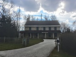
The eponymous King of Prussia Inn was originally constructed as a cottage in 1719 by the Welsh Quakers William and Janet Rees, founders of Reesville. The cottage was converted to an inn in 1769 and did a steady business in colonial times as it was approximately a day's travel by horse from Philadelphia. Settlers headed west to Ohio would sleep at the inn on their first night on the road. In 1774 the Rees family hired James Berry to manage the inn, which henceforth became known as "Berry's Tavern". General George Washington first visited the tavern on Thanksgiving Day in 1777 while the Continental Army was encamped at Whitemarsh; a few weeks later Washington and the army bivouacked at nearby Valley Forge. [5]

Parker's spy map, [6] [7] created by William Parker, an American Loyalist, listed the inn as "Berry's" in 1777, but a local petition in 1786 identified it as the "King of Prussia". It was possibly renamed in honor of Benjamin Franklin's pro-American satirical essay "An Edict by the King of Prussia". [8] [ failed verification ] At some point a wooden signboard of the inn depicted King Frederick II (Frederick the Great) of Prussia. The inn is listed on the National Register of Historic Places. [9]

20th century

The inn was forced to move with the expansion of U.S. Route 202. U.S. 202 is a major north–south highway that passes through the town from southwest to northeast. Its construction as an expressway would have caused the destruction of the King of Prussia Inn; however, historic preservationists managed to prevail upon the state of Pennsylvania to avoid this important structure by building north and southbound lanes on either side of it. For more than a quarter century, the inn was marooned on a median island, with motor traffic whizzing past on both sides. It was sealed up for years, surrounded by a high fence. The inn was successfully relocated in 2000 and re-opened to the public in October 2002.

The extensive suburban development that has taken place since the 1960s in King of Prussia has led urban planning scholars like Joel Garreau to label the area as an epitome of the edge city phenomenon, a situation where the most vibrant economic growth and prosperity in a metropolitan area (in this case, Philadelphia) no longer occurs in the urban center, but rather at its periphery. Before 1960, the Greater King of Prussia area was known for little more than being the place of Washington's winter respite in 1777-8 (see Valley Forge National Historical Park). [10] The growth in King of Prussia developed around the convergence of four highways with the construction of the King of Prussia mall, a large business park, and housing developments. [4]

Daniel Berrigan and his brother Philip Berrigan began their Plowshares Movement at the General Electric Weapons Plant in King of Prussia in 1980. That event and the subsequent court proceedings surrounding the 'Plowshares Eight' were dramatically depicted by Emile de Antonio in the 1983 motion picture In the King of Prussia. [11]

In the late 1980s, developer Dennis Maloomian acquired a golf course near the King of Prussia mall and planned a mixed-use residential and retail development that would include a town center for King of Prussia. The proposed development needed to be rezoned but Upper Merion Township officials and local residents were opposed to the plans. After several court battles, the Pennsylvania Supreme Court ruled in Maloomian's favor in 2003. The planned development became known as the Village at Valley Forge and would include a suburban downtown, apartments, townhouses, and offices. The retail area would be known as the King of Prussia Town Center. The first part of the town center was completed in 2014 with the opening of a Wegmans grocery store. This was followed by the construction of the downtown area with several stores and restaurants. Offices are being constructed and residential areas are in development. [4]

21st century

By the 2000s, the business park in King of Prussia was outdated and was losing tenants. By 2009, several office building owners pushed for Upper Merion Township to improve the business park. Improvements were made to King of Prussia including landscaping the median of US 202, installing King of Prussia signs at the borders to the community, creating a shuttle service connecting the business park to nearby train stations, and changing the zoning laws to allow for apartments and townhouses to be constructed in the business park. The vacancy rates at the business park have since dropped. [4]

In 2016, the two sections of the King of Prussia mall, The Plaza, and The Court, were joined to create one large shopping mall after an expansion corridor was built. [12]

Geography

Hanging Rock on what is now PA 320 in Gulph Mills
Gulph Rock.JPG
King of Prussia in 1919
Gulph rock 2019.jpg
King of Prussia in 2019

There is no incorporated city of King of Prussia, although the United States Postal Service office there has carried that name since 1837. Its ZIP Code is 19406. [13] King of Prussia's boundaries, as defined by the Census Bureau, are the Schuylkill River to the north, U.S. Route 422 to the west, Bridgeport to the east, and I-76 to the south. However, the Greater King of Prussia Area is often cited to include Bridgeport, parts of Wayne and Radnor Township, King Manor, as well as most of Gulph Mills and extreme eastern Tredyffrin Township, Chester County. The local fire department carries the King of Prussia name, whereas the police department and the school district carry the Upper Merion name. King of Prussia is located 20 miles (32 km) northwest of Philadelphia.

According to the U.S. Census Bureau, the CDP has a total area of 8.5 square miles (22 km2), of which 8.4 square miles (22 km2) is land and 0.1 square miles (0.26 km2), or 0.83%, is water.

The area is served by area codes 610 and 484.

Demographics

Historical population
CensusPop.Note
1990 18,406
2000 18,5110.6%
2010 19,9367.7%
2020 24,69523.9%
[14] [15] [2]

As of the 2010 census, the CDP was 69.4% White Non-Hispanic, 5.7% Black or African American, 0.3% Native American, 18.6% Asian, and 2.1% were two or more races. 4.2% of the population were of Hispanic or Latino ancestry. 22.4% of the population was foreign-born. [16]

As of the census [17] of 2000, there were 18,511 people, 8,245 households, and 4,773 families residing in the CDP. The population density was 2,202.4 inhabitants per square mile (850.4/km2). There were about 8,705 housing units at an average density of 1,035.7 per square mile (399.9/km2). The racial makeup of the CDP was 82.70% White, 10.62% Asian, 4.26% Black or African American, 0.16% Native American, 0.04% Pacific Islander, 0.84% from other races, and 1.39% from two or more races. 1.91% of the population were Hispanic or Latino of any race.

There were 8,245 households, out of which 21.1% had children under the age of 18 living with them, 49.2% were married couples living together, 6.3% had a female householder with no husband present, and 42.1% were non-families. 33.1% of all households were made up of individuals, and 8.1% had someone living alone who was 65 years of age or older. The average household size was 2.22 and the average family size was 2.89.

In the CDP, the population was spread out, with 17.6% under the age of 18, 8.4% from 18 to 24, 35.1% from 25 to 44, 22.2% from 45 to 64, and 16.7% who were 65 years of age or older. The median age was 37 years. For every 100 females, there were 97.6 males. For every 100 females age 18 and over, there were 96.1 males.

The median income for a household in the CDP was $62,012, and the median income for a family was $75,882. Males had a median income of $50,803 versus $37,347 for females. The per capita income for the CDP was $32,070. 3.2% of the population and 1.6% of families were below the poverty line. 1.8% of those under the age of 18 and 2.1% of those 65 and older were living below the poverty line.

Climate

The climate in this area is characterized by hot, humid summers and cool to cold winters. According to the Köppen Climate Classification system, King of Prussia had a humid continental climate, abbreviated "Dfa" on climate maps. [18] The most recent numbers show all months averaging above freezing so that the climate is now humid subtropical (Cfa). Three months are above 22°C (71.6°F) and seven months are above 10°C (50°F). The hardiness zone is 7a bordering 7b to the east.

Climate data for King of Prussia, Pennsylvania
MonthJanFebMarAprMayJunJulAugSepOctNovDecYear
Record high °F (°C)76
(24)
75
(24)
83
(28)
98
(37)
98
(37)
100
(38)
108
(42)
106
(41)
102
(39)
90
(32)
85
(29)
76
(24)
108
(42)
Mean daily maximum °F (°C)40
(4)
44
(7)
53
(12)
64
(18)
74
(23)
83
(28)
87
(31)
86
(30)
78
(26)
67
(19)
56
(13)
45
(7)
65
(18)
Mean daily minimum °F (°C)22
(−6)
24
(−4)
31
(−1)
41
(5)
51
(11)
61
(16)
66
(19)
64
(18)
56
(13)
44
(7)
35
(2)
27
(−3)
44
(6)
Record low °F (°C)−12
(−24)
−5
(−21)
8
(−13)
15
(−9)
29
(−2)
28
(−2)
48
(9)
40
(4)
35
(2)
26
(−3)
14
(−10)
−10
(−23)
−12
(−24)
Average precipitation inches (mm)3.40
(86)
3.17
(81)
4.00
(102)
4.03
(102)
4.21
(107)
3.98
(101)
4.76
(121)
4.37
(111)
4.87
(124)
3.73
(95)
3.80
(97)
4.17
(106)
48.49
(1,233)
Source: The Weather Channel [19]
Climate data for Norristown, Pennsylvania (1991–2020 normals, extremes 1951–present)
MonthJanFebMarAprMayJunJulAugSepOctNovDecYear
Record high °F (°C)76
(24)
78
(26)
84
(29)
98
(37)
98
(37)
100
(38)
108
(42)
106
(41)
102
(39)
92
(33)
85
(29)
76
(24)
108
(42)
Mean daily maximum °F (°C)41.7
(5.4)
43.5
(6.4)
52.1
(11.2)
64.8
(18.2)
74.8
(23.8)
84.0
(28.9)
88.8
(31.6)
86.5
(30.3)
80.0
(26.7)
68.4
(20.2)
56.8
(13.8)
46.3
(7.9)
65.6
(18.7)
Daily mean °F (°C)32.1
(0.1)
34.1
(1.2)
41.8
(5.4)
53.1
(11.7)
63.4
(17.4)
73.0
(22.8)
77.7
(25.4)
75.9
(24.4)
68.8
(20.4)
56.5
(13.6)
45.9
(7.7)
37.3
(2.9)
55.0
(12.8)
Mean daily minimum °F (°C)22.6
(−5.2)
24.7
(−4.1)
31.6
(−0.2)
41.5
(5.3)
52.1
(11.2)
62.0
(16.7)
66.6
(19.2)
65.2
(18.4)
57.6
(14.2)
44.6
(7.0)
35.1
(1.7)
28.3
(−2.1)
44.3
(6.8)
Record low °F (°C)−12
(−24)
−5
(−21)
8
(−13)
15
(−9)
29
(−2)
41
(5)
48
(9)
40
(4)
35
(2)
26
(−3)
14
(−10)
−10
(−23)
−12
(−24)
Average precipitation inches (mm)3.66
(93)
2.98
(76)
4.41
(112)
3.90
(99)
4.25
(108)
4.20
(107)
4.70
(119)
4.98
(126)
4.91
(125)
4.32
(110)
3.61
(92)
4.73
(120)
50.65
(1,287)
Average snowfall inches (cm)6.8
(17)
10.9
(28)
3.0
(7.6)
0.2
(0.51)
0.0
(0.0)
0.0
(0.0)
0.0
(0.0)
0.0
(0.0)
0.0
(0.0)
0.1
(0.25)
0.1
(0.25)
4.2
(11)
25.3
(64)
Average precipitation days (≥ 0.01 in)11.09.411.112.814.111.910.710.48.911.29.310.5131.3
Average snowy days (≥ 0.1 in)3.32.91.60.10.00.00.00.00.00.10.11.49.5
Source: NOAA [20] [21]

Economy

King of Prussia mall King of Prussia Mall entrance between Neiman Marcus and Macy's.jpg
King of Prussia mall
King of Prussia Town Center, which opened in 2016 KOPTownCenter.jpg
King of Prussia Town Center, which opened in 2016

King of Prussia has an unemployment rate of 4.30% and an annual job growth of about 1.44% and 38% over the next ten years. [22] A large portion of that comes from the King of Prussia mall, the third largest shopping complex in the United States by shopping area square footage and the numerous employers in the area. The King of Prussia mall consists of over 450 stores, including several luxury retailers, and 8 anchor stores. The mall attracts 22 million visitors annually and produces $1.1 billion in annual sales. [23] A large business park is located to the northwest of the King of Prussia mall, with over 60 commercial and industrial companies on 676 acres. There are about 60,000 people employed in King of Prussia, which is three times the resident population. [4]

King of Prussia is home to the headquarters of Nuclear Regulatory Commission Region I, which oversees 25 nuclear power reactors at 16 nuclear power plants in the Northeastern United States. [24]

According to Upper Merion Township's 2010 Comprehensive Annual Financial Report, [25]

#Employer# of EmployeesCommunity
1 GlaxoSmithKline 2,259King of Prussia
2 Lockheed Martin 2,255King of Prussia
3Valley Forge Colonial LTD1,117King of Prussia
4US Liability Insurance Co.938King of Prussia
5 Phila. Media Newspapers Inc. 843King of Prussia
6 Radial 742 Wayne
7 Arkema 639King of Prussia
8 BNY Mellon Investment Servicing 638King of Prussia
9 HIBU of PA 635King of Prussia
10 Commonwealth of PA 574King of Prussia

In addition, major commercial property owners in King of Prussia formed an organization in 2010 called the King of Prussia District (KOP-BID) that works to improve the physical environment, market the area, and advocate for zoning, tax and transportation policies that will keep King of Prussia competitive in the region. [26]

Sports

The Philadelphia Freedoms tennis team of World TeamTennis played in King of Prussia in 2008 and 2009. Whenever a tennis event was to occur, a temporary tennis stadium that seated 3,000 was constructed in the parking lot of the King of Prussia mall. Eventually, the Freedoms left for The Pavilion at Villanova University in 2010. [27]

Education

Schools

Public school students in the King of Prussia area attend schools in the Upper Merion Area School District. The district is currently served by five elementary schools: Bridgeport, Caley, Candlebrook, Gulph and Roberts. Belmont Terrace Elementary School, which was built in 1958, closed as an elementary school in 1982 [28] . All students in the Upper Merion Area School District also attend Upper Merion Area Middle School and Upper Merion Area High School.

King of Prussia also has a private school, Mother Teresa Regional Catholic School. [29] It was formed in 2012 by the merger of Mother of Divine Providence in King of Prussia and St. Teresa of Avila in West Norriton. [30]


Colleges

The Penn State Great Valley campus was once located in King of Prussia from 1963 to 1974 before relocating to Great Valley. In 1982, the college opened up a new facility called Penn State King of Prussia Center.

Points of interest

The King of Prussia Volunteer Fire Company 9/11 Memorial, a tribute to King of Prussia firemen who supported rescue efforts in the September 11 attacks King of Prussia 9-11 Memorial.jpg
The King of Prussia Volunteer Fire Company 9/11 Memorial, a tribute to King of Prussia firemen who supported rescue efforts in the September 11 attacks

King of Prussia is home to the King of Prussia mall, which is the third largest mall in the United States in terms of leasable space. The mall consists of over 450 stores, 8 anchor stores, and over 40 restaurants. The mall has several luxury stores that have their only Philadelphia area location in King of Prussia. [23] [31] The King of Prussia mall is surrounded by several big-box stores, restaurants, hotels, and other businesses, including a United Artists Theatres and an iFLY indoor skydiving center. [32] [33] The King of Prussia Town Center is a lifestyle center that consists of Wegmans, multiple other big-box retailers, and a downtown area with dining, retail, and service establishments and a Town Square. [4] [34] The town center is part of the Village at Valley Forge, a 122-acre mixed-use development under construction that consists of retail, apartments, townhouses, condominiums, office space, and the Children's Hospital of Philadelphia's "Specialty Care and Surgery Center". [4] [35]

King of Prussia is also the location of the Valley Forge Casino Resort, which has over 500 hotel rooms, 600 slot machines, table games, sports betting, seven restaurants, a spa, nightlife, a convention center, and a seasonal poolside club called Valley Beach. [36] Valley Forge National Historical Park, which consists of the site where General George Washington and the Continental Army made their encampment at Valley Forge during the winter of 1777–78 in the American Revolutionary War, is located to the west of King of Prussia. [37]

King of Prussia is home to the King of Prussia Volunteer Fire Company 9/11 Memorial honoring the lives lost in the September 11 attacks. The memorial, which was dedicated by the King of Prussia Volunteer Fire Company on the 10th anniversary of the attacks in 2011, consists of two steel beams recovered from Ground Zero at the World Trade Center in New York City. The 9/11 Memorial is located adjacent to the King of Prussia Volunteer Fire Company station on Allendale Road across from the King of Prussia mall. [38] [39]

Infrastructure

Transportation

US 202 northbound entering King of Prussia at Gulph Road US 202 NB at Gulph Road.jpg
US 202 northbound entering King of Prussia at Gulph Road

King of Prussia has retained its role as an important crossroads throughout United States history. In addition to the Inn, from the earliest days, the intersection supported two general stores. Today, four major highways meet in or near the center of King of Prussia. The Schuylkill Expressway (I-76), which leads to Center City Philadelphia 19 miles (31 km) away, ends in King of Prussia at the Pennsylvania Turnpike, an east–west toll road across the southern portion of the state that heads west towards Harrisburg as part of I-76 and east across the northern suburbs of Philadelphia towards New Jersey as I-276. The US 422 freeway begins at US 202 near the center of town and heads northwest to Pottstown and Reading; thanks to reconstruction in 2000, motorists can now travel directly from Reading to Philadelphia without passing onto US 202. US 202 is the only major highway that becomes a surface road through the area, heading southwest towards West Chester as a freeway and northeast towards Norristown as Dekalb Pike, a surface road. Important local roads in King of Prussia include PA 23, which runs through King of Prussia between Valley Forge and Bridgeport along Valley Forge Road; Gulph Road, which runs from PA 23 near Valley Forge National Historical Park and heads southeast to junctions with I-76 and US 202 near the King of Prussia mall before leading to Gulph Mills; and Henderson Road, a north–south road through King of Prussia that intersects PA 23 and US 202 before ending at Gulph Road near an interchange with I-76. [40] [41]

Pennsylvania Department of Transportation District 6, which serves Bucks, Chester, Delaware, Montgomery, and Philadelphia counties, is headquartered in King of Prussia. [42]

King of Prussia Transit Center at the King of Prussia mall King of Prussia Transit Center January 2018.jpg
King of Prussia Transit Center at the King of Prussia mall

King of Prussia is served by SEPTA Suburban Division bus routes 92 , 99 , 123 , 124 , 125, and 139 at the King of Prussia Transit Center at the King of Prussia mall, with the routes providing service to West Chester, the Norristown Transportation Center, Phoenixville, the 69th Street Transportation Center, Center City Philadelphia, Chesterbrook, Valley Forge, and Limerick. In addition, SEPTA Suburban Division bus route 95 runs from Gulph Mills to the Willow Grove Park Mall in Willow Grove. The Gulph Mills station is served by SEPTA's Norristown High Speed Line, which runs between the 69th Street Transportation Center and the Norristown Transportation Center. [43]

The Greater Valley Forge Transportation Management Association operates The Rambler as a community shuttle around the King of Prussia area Monday through Saturday, serving residential areas, shopping centers, the King of Prussia mall, medical facilities, the Upper Merion Senior Center, and the Upper Merion Township Municipal Building. [44] [45] Taxicab and limousine service in King of Prussia is provided by three companies. [46] Carpooling is available in King of Prussia, with the Delaware Valley Regional Planning Commission offering a service that can match commuters with transit services, carpools, vanpools, and walking and bicycling options. [47]

OurBus provides intercity bus service from King of Prussia to Park Avenue in the Manhattan section in New York City as part of a route running from Lancaster to New York City. The bus stop in King of Prussia is located at the King of Prussia Park and Ride, a park and ride lot on King of Prussia Road. The route started on December 21, 2017. [48] [49] Fullington Trailways provides intercity bus service from the King of Prussia Park and Ride along a route serving Philadelphia, Harrisburg, State College, and DuBois. [50] [51] Greyhound Lines also has a bus stop at the King of Prussia Park and Ride. [52]

King of Prussia is 18 miles (29 km) from 30th Street Station in Philadelphia, which has intercity rail service provided by Amtrak, and 26 miles (42 km) from Philadelphia International Airport, which has flights to domestic and international destinations. [47]

Norfolk Southern Railway operates freight trains through King of Prussia along the Harrisburg Line that follows the Schuylkill River and the Dale Secondary that follows US 202 and the Pennsylvania Turnpike. [41] [53] The Abrams Yard operated by Norfolk Southern Railway is located in King of Prussia on the Harrisburg Line. [53] [54]

There are several trails for hiking and bicycles that serve the King of Prussia area, some of which are under development. Valley Forge National Historical Park has a network of trails that total over 20 miles (32 km), including the Joseph Plumb Martin Trail and the Chapel Trail. The Schuylkill River Trail connects Valley Forge National Historical Park via Sullivan's Bridge across the Schuylkill River to the Manayunk section of Philadelphia, following the riverbank. [55] When complete, the Schuylkill River Trail will follow the river between Pottsville and Philadelphia for a total length of about 130 miles (210 km). [56] A section of the Chester Valley Trail passes through King of Prussia; when complete, the trail will run 22 miles (35 km) between Norristown, where it will connect to the Schuylkill River Trail, and Exton. [55] [57]

Utilities

Electricity and natural gas in King of Prussia is provided by PECO Energy Company, a subsidiary of Exelon. [58] [59] [60] Water in the King of Prussia area is provided by Aqua Pennsylvania, a subsidiary of Aqua America, [61] and Pennsylvania American Water, a subsidiary of American Water. [62] The Upper Merion Township Public Works Department provides wastewater service to King of Prussia. [63] Trash and recycling collection in King of Prussia is provided by private haulers. [64]

Health care

Children's Hospital facility in King of Prussia Specialty Care and Surgery Center, King of Prussia, Pennsylvania.jpg
Children's Hospital facility in King of Prussia

Einstein Healthcare Network operates an outpatient healthcare facility in King of Prussia. [65] The Children's Hospital of Philadelphia's 135,000-square-foot (13,000 m2) "Specialty Care and Surgery Center" opened in King of Prussia in 2015. [66] The Gulph Road facilities includes practices in sports medicine, oncology, and pediatric imagery. The facility is part of a larger site known the Village at Valley Forge. [67] On January 26, 2022, the Children's Hospital of Philadelphia opened the Middleman Family Pavilion, an 250,000-square-foot (23,000 m2) hospital, in King of Prussia. [68]

Notable people

Related Research Articles

<span class="mw-page-title-main">Montgomery County, Pennsylvania</span> County in Pennsylvania, United States

Montgomery County, colloquially referred to as Montco, is a county in the Commonwealth of Pennsylvania. As of the 2020 census, the population of the county was 856,553, making it the third-most populous county in Pennsylvania after Philadelphia and Allegheny counties.

<span class="mw-page-title-main">Phoenixville, Pennsylvania</span> Borough in Pennsylvania, United States

Phoenixville is a borough in Chester County, Pennsylvania, United States. It is located 28 miles (45 km) northwest of Philadelphia at the junction of French Creek and the Schuylkill River. It is in the Philadelphia metropolitan area. According to a 2022 estimate, the population was 19,354.

<span class="mw-page-title-main">Audubon, Pennsylvania</span> Census-designated place in Pennsylvania, United States

Audubon is a census-designated place (CDP) in Lower Providence Township, Montgomery County, Pennsylvania, United States. It was named for naturalist John James Audubon, who lived there as a young man. The population was 8,433 at the 2010 census.

<span class="mw-page-title-main">Lower Providence Township, Pennsylvania</span> Township in Pennsylvania, United States

Lower Providence Township is a township in Montgomery County, Pennsylvania, United States. The township is located approximately 17 miles northwest of Philadelphia. The population was 25,625 at the 2020 census.

<span class="mw-page-title-main">Plymouth Meeting, Pennsylvania</span> Census-designated place in Pennsylvania, United States

Plymouth Meeting is a census-designated place (CDP) that straddles Plymouth and Whitemarsh Townships in Montgomery County, Pennsylvania, United States. The settlement was founded in 1686.

<span class="mw-page-title-main">Upper Merion Township, Pennsylvania</span> Township in Pennsylvania, United States of America

Upper Merion Township is a township in Montgomery County, Pennsylvania. The population was 33,613 at the 2020 U.S. Census. Located 16 miles (26 km) from Philadelphia, it consists of the villages of Gulph Mills, King of Prussia, Swedeland, Swedesburg, and portions of Radnor, and Wayne.

<span class="mw-page-title-main">Upper Providence Township, Montgomery County, Pennsylvania</span> Township in Pennsylvania, United States

Upper Providence Township is a township in Montgomery County, Pennsylvania, United States. As of the 2010 census, the township population was 21,219.

<span class="mw-page-title-main">Philadelphia Main Line</span> Collection of suburban communities in Pennsylvania, United States

The Philadelphia Main Line, known simply as the Main Line, is an informally delineated historical and social region of suburban Philadelphia, Pennsylvania. Lying along the former Pennsylvania Railroad's once prestigious Main Line, it runs northwest from Center City Philadelphia parallel to Lancaster Avenue, also known as U.S. Route 30.

<span class="mw-page-title-main">King of Prussia (shopping mall)</span> Shopping mall in Pennsylvania, U.S.

King of Prussia, also referred to as King of Prussia Mall, is a shopping mall located in the community of King of Prussia in Upper Merion Township, Pennsylvania. It is the largest shopping mall in Pennsylvania and the third-largest shopping mall in the United States in terms of gross leasable area. It is an upscale mall with 450 retailers.

<span class="mw-page-title-main">Norristown High Speed Line</span> Interurban rapid transit line in Philadelphia

The Norristown High Speed Line (NHSL), the P&W, or Route 100, is a 13.4-mile (21.6 km) interurban light rapid transit line operated by SEPTA, running between the 69th Street Transportation Center in Upper Darby and the Norristown Transportation Center in Norristown, Pennsylvania. Originally the Philadelphia and Western Railroad line, the line runs entirely on its own right-of-way. By 2020, the Norristown High Speed Line had an average weekday ridership approaching 11,000 passengers.

<span class="mw-page-title-main">Schuylkill Expressway</span> Highway in Pennsylvania

The Schuylkill Expressway, locally known as "the Schuylkill", is a freeway through southern Montgomery County and the city of Philadelphia. It is the easternmost segment of Interstate 76 (I-76) in the U.S. state of Pennsylvania. It extends from the Valley Forge interchange of the Pennsylvania Turnpike in King of Prussia, paralleling its namesake Schuylkill River for most of the route, southeast to the Walt Whitman Bridge over the Delaware River in South Philadelphia. It serves as the primary corridor into Philadelphia from points west. Maintenance and planning for most of the highway are administered through Pennsylvania Department of Transportation (PennDOT) District 6, with the Delaware River Port Authority (DRPA) maintaining the approach to the Walt Whitman Bridge.

<span class="mw-page-title-main">U.S. Route 422</span> Highway in Ohio and Pennsylvania

U.S. Route 422 (US 422) is a 271-mile-long (436 km) spur route of US 22 split into two segments in the U.S. states of Ohio and Pennsylvania. The western segment of US 422 runs from downtown Cleveland, Ohio, east to Ebensburg, Pennsylvania. The eastern segment, located entirely within Pennsylvania, runs from Hershey east to King of Prussia, near Philadelphia. US 422 Business serves as a business route into each of four towns along the way.

<span class="mw-page-title-main">Pennsylvania Route 363</span> A state highway located in Montgomery County, Pennsylvania

Pennsylvania Route 363 (PA 363) is a state highway located in Montgomery County, Pennsylvania that is a spur of PA 63. The route runs 11.96 mi (19.25 km) from an interchange with U.S. Route 422 (US 422) in Audubon northeast to an intersection with PA 63 in Lansdale. The route runs mostly through suburban areas of central Montgomery County, passing some farmland in Worcester Township. PA 363 is designated along Trooper Road, Ridge Pike, Park Avenue, and Valley Forge Road. In the community of Worcester, the route crosses PA 73.

<span class="mw-page-title-main">Gulph Mills station</span> Rapid transit station in Pennsylvania

Gulph Mills station is a SEPTA rapid transit station in Gulph Mills, Pennsylvania. It serves the Norristown High Speed Line and is officially located at Trinity Road and Crest Lane in Upper Merion Township, however another parking lot can be found across the tracks on South Gulph Road. This parking lot is only accessible for northbound drivers along South Gulph Road, though. All trains stop at Gulph Mills. Transfers are available for buses to the King of Prussia mall. The station lies 10.3 track miles (16.6 km) from 69th Street Terminal. There is off-street parking available at this station.

<span class="mw-page-title-main">Pennsylvania Route 320</span> State highway in Pennsylvania, US

Pennsylvania Route 320 is a north–south state highway in southeastern Pennsylvania. The southern terminus of the 18.8-mile (30.3 km) long route is at U.S. Route 13 /PA 291 in Chester. The northern terminus is at PA 23 in Swedeland. The route passes through suburban areas in Delaware and Montgomery counties to the west of Philadelphia, serving Swarthmore, Springfield, Broomall, Villanova, and Gulph Mills. PA 320 intersects many important highways including US 13 Business and Interstate 95 (I-95) in Chester, US 1 in Springfield, US 30 in Villanova, and I-76 in Gulph Mills. PA 320 runs parallel to I-476 for much of its length and crosses it four times. Even though there are no direct interchanges between I-476 and PA 320, several roads that intersect PA 320 provide access to I-476.

<span class="mw-page-title-main">Pennsylvania Route 23</span> State highway in Pennsylvania, US

Pennsylvania Route 23 is an 81.14-mile-long (130.58 km) state highway in southeastern Pennsylvania. The route begins at PA 441 in Marietta and heads east to U.S. Route 1 at City Avenue on the border of Lower Merion Township and Philadelphia. PA 23 begins at Marietta in Lancaster County and continues east to Lancaster, where it passes through the city on a one-way pair of streets and intersects US 222 and US 30.

<span class="mw-page-title-main">Pennsylvania Route 252</span> State highway in Pennsylvania, US

Pennsylvania Route 252 is a north–south state highway in the U.S. state of Pennsylvania that connects PA 320 in Nether Providence Township at its southern terminus to PA 23 in Valley Forge at its northern terminus. The route runs through the western suburbs of Philadelphia in Delaware, Chester, and Montgomery counties, including Nether Providence Township, the borough of Media, Upper Providence Township, Marple Township, Newtown Township, Easttown Township, Tredyffrin Township, and Upper Merion Township. The route intersects many roads including U.S. Route 1 north of Media, PA 3 in Newtown Square, US 30 in Paoli, and US 202 near Berwyn.

<span class="mw-page-title-main">U.S. Route 202 in Pennsylvania</span> US Highway in Pennsylvania

U.S. Route 202 is a US Highway running from New Castle, Delaware, northeast to Bangor, Maine. The route runs through the southeastern part of the U.S. state of Pennsylvania, passing through the western and northern suburbs of Philadelphia in the Delaware Valley metropolitan area. US 202 serves largely as a toll-free bypass around the city, avoiding the busy traffic and congestion on Interstate 95 (I-95). It is signed north–south and follows a general southwest–northeast direction through the state, serving West Chester, King of Prussia, Bridgeport, Norristown, Montgomeryville, Doylestown, and New Hope. US 202 enters Pennsylvania from Delaware and heads north as a divided highway, where it becomes concurrent with US 322 at an intersection with US 1 in Painters Crossing. The two routes run north and become a freeway that bypasses West Chester to the east, with US 322 splitting from US 202. US 202 continues north and east along the freeway to King of Prussia, where it reverts to an at-grade divided highway following an interchange with I-76. The route becomes a one-way pair as it passes through Bridgeport and Norristown before both directions rejoin and the road continues northeast. US 202 follows an expressway-grade parkway between Montgomeryville and Doylestown prior to bypassing Doylestown to the south along a freeway. The route continues northeast as an at-grade road to New Hope, where it turns into a freeway again before it crosses the Delaware River on the New Hope–Lambertville Toll Bridge into New Jersey.

<span class="mw-page-title-main">King of Prussia Transit Center</span> SEPTA bus terminal

The King of Prussia Transit Center is a major bus terminal located at the King of Prussia mall in King of Prussia, Pennsylvania for SEPTA buses. The transit center serves SEPTA Suburban Division buses traveling to Center City Philadelphia via Route 124 or Route 125, Chesterbrook via Route 124, Valley Forge via Route 125, 69th Street station via Route 123, the Norristown Transportation Center and Phoenixville via Route 99, the West Chester Transportation Center via Route 92, and Limerick via Route 139.

<span class="mw-page-title-main">King of Prussia Town Center</span> Shopping mall in Pennsylvania, United States

King of Prussia Town Center is a lifestyle center in the census-designated place of King of Prussia, Pennsylvania, in Upper Merion Township, Montgomery County, Pennsylvania. The center is just west of the King of Prussia mall.

References

  1. "ArcGIS REST Services Directory". United States Census Bureau. Retrieved October 12, 2022.
  2. 1 2 "Census Population API". United States Census Bureau. Retrieved October 12, 2022.
  3. "King of Prussia". Geographic Names Information System . United States Geological Survey, United States Department of the Interior.
  4. 1 2 3 4 5 6 7 Huber, Robert (March 2017). "The Promised Land?". Philadelphia Magazine. pp. 76–79, 128–134.
  5. J. Michael Morrison, King of Prussia, Images of America series (Charleston, SC: Arcadia Publishing, 2005); Accessed 26 Oct 2016.
  6. "The King of Prussia Inn --Locate 1". www.nps.gov. Retrieved October 12, 2019.
  7. See also Morrison, King of Prussia, 2005 (above).
  8. Franklin, Benjamin. reprinted on The History Carper.
  9. Greater Valley Forge Chamber of Commerce. "King of Prussia's name". Accessed June 23, 2006.
  10. Infield, Tom (June 17, 2008). "King of Prussia still evolving". The Philadelphia Inquirer. Retrieved November 13, 2013.
  11. "In the King of Prussia" . Retrieved October 12, 2019 via www.imdb.com.
  12. Parmley, Suzette (August 20, 2016). "It's official: King of Prussia becomes one vast mall with 50 new retailers and restaurants". The Philadelphia Inquirer. Retrieved May 9, 2018.
  13. John L. Kay and Chester M. Smith, Jr., Pennsylvania Postal History: the Post Offices and First Postmasters from 1775 to 1994 (Lincoln, MA: Quarterman Publications, 1995), p. 305. The first P.O. in what is now King of Prussia was established in Reesville in 1820, changing to Upper Merion in 1829, and becoming King of Prussia on 5 April 1837. Initially it received service from Bridgeport and became a branch of Norristown in 1935 (pp. 309, 311).
  14. "King of Prussia, Pennsylvania (PA 19406) profile: population, maps, real estate, averages, homes, statistics, relocation, travel, jobs, hospitals, schools, crime, moving, houses, news, sex offenders". www.city-data.com. Retrieved October 12, 2019.
  15. "Census 2020".
  16. "King of Prussia CDP QuickFacts from the US Census Bureau". Archived from the original on March 10, 2013. Retrieved May 20, 2013.
  17. "U.S. Census website". United States Census Bureau . Retrieved January 31, 2008.
  18. "Climate Summary for King of Prussia, Pennsylvania". Weatherbase. Retrieved January 22, 2017.
  19. "Climate Statistics for King of Prussia, Pennsylvania" . Retrieved January 22, 2017.
  20. "NowData – NOAA Online Weather Data". National Oceanic and Atmospheric Administration. Retrieved August 9, 2021.
  21. "Station: Norristown, PA". U.S. Climate Normals 2020: U.S. Monthly Climate Normals (1991-2020). National Oceanic and Atmospheric Administration. Retrieved August 9, 2021.
  22. "Zip 19406 (King of Prussia, PA) Economy". www.bestplaces.net. Retrieved October 12, 2019.
  23. 1 2 "King of Prussia Mall Fact Sheet" (PDF). Simon Property Group . Retrieved January 19, 2017.
  24. "Region I Jurisdiction". Nuclear Regulatory Commission. Retrieved March 3, 2017.
  25. "CAFR Cover 2016". Upper Merion Township, Pennsylvania. Retrieved January 15, 2018. This links to the 2016 CAFR.
  26. "About Us". King of Prussia District. Retrieved February 5, 2017.
  27. George, John (January 26, 2010). "Philadelphia Freedoms of World Team Tennis moving home court to Villanova". Philadelphia Business Journal. Retrieved January 22, 2017.
  28. "UM and Bridgeport Public Schools Timeline". www.kophistory.org. Retrieved February 20, 2024.
  29. "Home | Mother Teresa Regional Catholic School I King of Prussia, Pa". Mother Teresa Region. Retrieved October 12, 2019.
  30. "2012 Catholic grade school consolidations/closings". Catholicphilly.com. July 15, 2012. Retrieved April 22, 2020.
  31. "King of Prussia Mall". Visit Philadelphia. Retrieved January 21, 2017.
  32. Google (March 3, 2017). "overview of King of Prussia Mall" (Map). Google Maps . Google. Retrieved March 3, 2017.
  33. "Overlook at King of Prussia". DDR Corp. Retrieved March 4, 2017.
  34. "About". King of Prussia Town Center. Retrieved March 2, 2017.
  35. "Home". The Village at Valley Forge. Retrieved March 2, 2017.
  36. "Valley Forge Casino Resort". Valley Forge & Montgomery County, PA. Retrieved February 1, 2017.
  37. "Valley Forge National Historical Park". National Park Service. Retrieved February 1, 2017.
  38. "9/11 Memorial". King of Prussia Volunteer Fire Company. Retrieved February 1, 2017.
  39. "King of Prussia 9/11 Memorial". VisitPA.com. Retrieved February 1, 2017.
  40. Montgomery County, Pennsylvania (Map) (18th ed.). 1"=2000'. ADC Map. 2006. ISBN   0-87530-775-2.
  41. 1 2 Montgomery County, Pennsylvania Highway Map (PDF) (Map). PennDOT. 2015. Retrieved January 12, 2016.
  42. "District 6". Pennsylvania Department of Transportation. Retrieved January 27, 2017.
  43. SEPTA Official Transit & Street Map Suburban (PDF) (Map). SEPTA. Retrieved May 2, 2016.
  44. "Transportation". Upper Merion Township. Retrieved April 17, 2018.
  45. "Upper Merion Rambler brochure" (PDF). Greater Valley Forge Transportation Management Association. Retrieved April 17, 2018.
  46. "Auto Access". King of Prussia District. Archived from the original on February 6, 2017. Retrieved February 5, 2017.
  47. 1 2 "By Car". King of Prussia District. Retrieved November 15, 2017.
  48. "Book an Intercity (Prime) Ticket". OurBus. Retrieved February 14, 2018.
  49. Rettew Jr., Bill (December 16, 2017). "Company plans bus service from West Chester to New York City". Daily Local News. West Chester, PA. Retrieved February 14, 2018.
  50. "FAB 750 – Dubois - State College - Harrisburg - Philadelphia". Fullington Tours. Retrieved June 6, 2022.
  51. "FAB 751 -- Philadelphia - Harrisburg - State College - Dubois". Fullington Tours. Retrieved June 6, 2022.
  52. "King of Prussia Park & Ride in Norristown, Pennsylvania". Greyhound Lines. Retrieved August 2, 2020.
  53. 1 2 "Norfolk Southern Harrisburg Region Timetable 1, August 4, 2008" (PDF). Retrieved October 12, 2019.
  54. Gamble, Oscar (November 13, 2015). "Train derailment at Norfolk Southern Abrams Yard in Upper Merion under investigation". Daily Local News. West Chester, PA. Retrieved November 19, 2017.
  55. 1 2 "Bike Trails". King of Prussia District. Retrieved February 16, 2017.
  56. "Home". Schuylkill River Trail. Retrieved February 16, 2017.
  57. "Chester Valley Trail". Montgomery County, Pennsylvania. Retrieved February 16, 2017.
  58. "PECO: Company Information". PECO Energy Company. Retrieved January 29, 2017.
  59. "Electric Service Tariff" (PDF). PECO Energy Company. July 17, 2017. p. 4. Retrieved October 10, 2017.
  60. "Gas Service Tariff" (PDF). PECO Energy Company. August 30, 2017. p. 2. Retrieved October 10, 2017.
  61. "Rates and Rules Governing the Distribution of Water" (PDF). Aqua Pennsylvania. March 11, 2013. p. 3. Retrieved October 11, 2017.
  62. "Rates, Rules and Regulations Governing the Distribution and Sale of Water Service" (PDF). Pennsylvania American Water. August 8, 2018. p. 11. Retrieved September 9, 2018.
  63. "Wastewater Management". Upper Merion Township. Retrieved September 10, 2018.
  64. "Public Works". Upper Merion Township. Retrieved September 10, 2018.
  65. "Einstein Healthcare Network King of Prussia". Einstein Healthcare Network. Retrieved February 7, 2017.
  66. "The Children's Hospital of Philadelphia Opens New Specialty Care and Ambulatory Surgery Center in King of Prussia". Children's Hospital of Philadelphia. May 18, 2015.
  67. PULEO, GARY. "Children's Hospital of Philadelphia to build new facility in King of Prussia". Main Line Media News. Retrieved October 12, 2019.
  68. Davis, Corey (January 26, 2022). "CHOP's 2nd hospital, located in King of Prussia, is now open". Philadelphia, PA: WPVI-TV. Retrieved January 26, 2022.
  69. Jeffries, David. "Bloodhound Gang – Music Biography, Credits and Discography". AllMusic. Retrieved January 19, 2013.
  70. Jobriath
  71. Hoare, Patrick T. (Winter 2005). "PROFILE: REV. MSGR. MICHAEL J. FITZGERALD, VICE RECTOR, ST. CHARLES BORROMEO SEMINARY" (PDF). The Brook. Archived from the original (PDF) on June 26, 2010.
  72. "KofP prodigy in $1.5B Oracle cloud software deal". The Philadelphia Inquirer. October 26, 2011. Retrieved November 14, 2017.
  73. Player profile: Ann Li. International Tennis Federation. Accessed on August 28, 2017.