Whitpain Township, Pennsylvania

Last updated
Whitpain Township
DAWESFIELD.jpg
Whitpain Township Montgomery County.png
Location of Pennsylvania in the United States
Coordinates: 40°09′21″N75°17′02″W / 40.15583°N 75.28389°W / 40.15583; -75.28389
CountryUnited States
StatePennsylvania
County Montgomery
Area
[1]
  Total12.86 sq mi (33.3 km2)
  Land12.85 sq mi (33.3 km2)
  Water0.01 sq mi (0.03 km2)
Elevation
259 ft (79 m)
Population
 (2010)
  Total18,875
  Estimate 
(2016) [2]
19,308
  Density1,500/sq mi (570/km2)
Time zone UTC-5 (EST)
  Summer (DST) UTC-4 (EDT)
Area code(s) 610, 484
FIPS code 42-091-84888
Website www.whitpaintownship.org

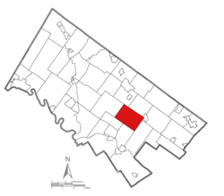
Whitpain Township is a township in Montgomery County, Pennsylvania, United States. Founded in 1701, it has grown to a total population of 18,875 as of the 2010 census.

Contents

Geography

According to the United States Census Bureau, the township has a total area of 12.9 square miles (33 km2), of which 0.08% is water. Whitpain Township is approximately four and a half miles by three miles. There are two watersheds in the township, Wissahickon Creek (which was once known as "Whitpaine's Creek") and Stony Creek.

Demographics

Historical population
CensusPop.Note
1930 2,328
1940 2,4515.3%
1950 3,06325.0%
1960 7,331139.3%
1970 9,24526.1%
1980 11,77227.3%
1990 15,67333.1%
2000 18,56218.4%
2010 18,8751.7%
2020 20,3337.7%
U.S. Decennial Census [3] [4]

As of the 2010 census, the township was 80.0% White, 5.2% Black or African American, 0.1% Native American, 10.9% Asian, and 1.3% were two or more races. 2.6% of the population were of Hispanic or Latino ancestry. [5]

As of the census [6] of 2000, there were 18,562 people, 6,960 households, and 5,206 families residing in the township. The population density was 1,436.3 inhabitants per square mile (554.6/km2). There were 7,305 housing units at an average density of 565.3 per square mile (218.3/km2). The racial makeup of the township was 86.31% White, 4.69% African American, 0.06% Native American, 7.82% Asian, 0.23% from other races, and 0.89% from two or more races. Hispanic or Latino of any race were 1.33% of the population.

There were 6,960 households, out of which 34.0% had children under the age of 18 living with them, 66.3% were married couples living together, 6.5% had a female householder with no husband present, and 25.2% were non-families. 21.3% of all households were made up of individuals, and 9.2% had someone living alone who was 65 years of age or older. The average household size was 2.64 and the average family size was 3.10.

In the township the population was spread out, with 25.0% under the age of 18, 5.1% from 18 to 24, 27.0% from 25 to 44, 27.9% from 45 to 64, and 14.9% who were 65 years of age or older. The median age was 41 years. For every 100 females, there were 93.1 males. For every 100 females age 18 and over, there were 89.2 males.

The median income for a household in the township was $88,933, and the median income for a family was $103,613. Males had a median income of $68,125 versus $44,079 for females. The per capita income for the township was $41,739. About 1.7% of families and 3.1% of the population were below the poverty line, including 3.7% of those under age 18 and 3.3% of those age 65 or over.

History

Whitpain is one of the oldest townships in Montgomery County. Richard Whitpaine, a London butcher, purchased a 4,500-acre (1,800 ha) tract of land as part of William Penn’s "Holy Experiment". His 16-year-old son, Zechariah, travelled to Pennsylvania on the ship Welcome with Penn in 1682 to settle his father's properties and escape persecution of his Quaker beliefs. By 1685, Zechariah had established a plantation house along Wissahickon Creek near Mount Pleasant, with his bride Sarah Songhurst, whom he had met on the Welcome.

In Holme's Map of 1681, Whitpain Township is called "Whitpain's Creek". Whitpain Township has been an independent township since 1701, as it appears as "Whitpain's Township" in the survey of all the townships in the Commonwealth ordered by William Penn. The borders of Whitpain Township changed dramatically in 1733, when Worcester Township was created, taking away a significant portion of its area. For a brief period in 1762, Whitpain and Plymouth Township, by act of the Assembly, became one district with one supervisor from each township. Dissatisfaction by the populace of both townships led the Assembly to repeal the act in 1763.

By 1734, Whitpain Township had 24 landowners. It maintained steady growth for more than two centuries, expanding from 771 people in 1800 to 3,063 people in 1950. In recent years, the township has experienced rapid growth. Today, Whitpain Township is home to over 18,000 residents.

Early settlers to Whitpain Township were farmers. Industry came to the region in 1727, when Jacob Yost began a weaving enterprise in Centre Square. Charles Mather built an additional mill in 1804. Although a rural farming community for decades, the growth of recent years has included business development, making Whitpain Township home to several of the Philadelphia region's largest corporations, including Aetna US Healthcare and Unisys.

Although today Whitpain Township is home to residents of many religions and nationalities, its earliest settlers were Protestant and Quaker. Prior to the Revolutionary War, the township had two churches: Boehm's Reformed Church (circa 1740), and St. John's Lutheran Church (circa 1769).

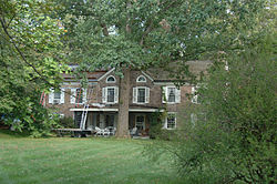
Whitpain Township earned a place in history during the Revolutionary War, when George Washington and many of his generals spent time in the township. Dawesfield, a home on Lewis Lane, is considered the most significant historic site in the township because it was Washington's headquarters from October 21 to November 2, 1777. Dawesfield was listed on the National Register of Historic Places in 1991. [7]

Communities within Whitpain Township

Today, Whitpain Township is a composite of several small communities established before and after the Revolutionary War. They include West Ambler, Center Square, Blue Bell, Broad Axe, Custer, Franklinville, Washington Square and Belfry.

Most of Whitpain Township is covered by the Blue Bell, Pennsylvania ZIP code. In recent years the name "Blue Bell" has become largely synonymous with much of the township, eclipsing many of the older community designations.

Government

Whitpain Township municipal building Whitpain Twp Building.jpg
Whitpain Township municipal building
Presidential elections results [8]
Year Republican Democratic
2020 34.9% 4,76363.5%8,660
2016 36.6% 4,30659.2%6,953
2012 47.8% 5,37351.3%5,760
2008 43.3% 4,85556.2%6,299
2004 48.4% 5,33451.1%5,631
2000 49.4%4,84248.6% 4,763
1996 49.4%4,08642.3% 3,501
1992 47.6%3,95335.5% 2,954

Under Pennsylvania law, Whitpain Township is a Township of the Second Class. It is governed by a five-member Board of Supervisors elected at-large by the electorate. Members of the Board of Supervisors serve six year terms. Every two years, two of the seats come up for election. The exception is in the sixth year in the cycle, when only one seat comes up for election.

Most, if not all, of the executive and legislative powers allocated to Whitpain Township in the State Second Class Township Code are vested in the Board of Supervisors. The Board of Supervisors is empowered to appoint professionals to assist it in the operation of the Township and to furnish advice and counsel on technical matters. Additionally, the Board appoints all the members of the various boards and commissions as well as the Zoning Hearing Board and the Planning Commission. Also, the Board of Supervisors hears conditional use applications in accordance with the Municipalities Planning Code and the Whitpain Township Zoning Ordinance. The levying of township taxes and the appropriations to the various departments and subsidiary boards and commissions is the responsibility of the Board of Supervisors. During the months of November and December, public hearings are held for the purpose of reviewing the budget for the following year.

The current membership of the Board of Supervisors (as of the election of November 2013) consists of:

  • Frederick R. Conner, Chairman
  • Adam Zucker, Vice Chairman
  • Anthony F. Greco, Secretary
  • Melissa Murphy Weber, Treasurer
  • Ken Wollman, Assistant Secretary

The township government is located at 960 Wentz Road, Blue Bell, PA 19422.

Federally, Whitpain Township is part of the 4th Congressional District, represented by Democrat Madeleine Dean.

Economy

Unisys and Kappa Publishing Group are headquartered in Blue Bell in Whitpain Township. [9] [10] [11]

Top employers

According to Whitpain Township's 2014 Comprehensive Annual Financial Report, [12] the top employers in the township are:

#Employer# of Employees
1 Aetna 1,251
2 Montgomery County Community College 1,239
3Henkels & McCoy723
4The Carney Group391
5 Unisys 386
6 PMA Companies 311
7 Wissahickon School District 246
8 Express Scripts 245
9Hansen Properties224
10 ACTS Retirement-Life Communities 223

Education

The Wissahickon School District provides public education to the children of Whitpain Township, as well as those from Lower Gwynedd Township and Ambler Borough. Within the township are three of the district's five elementary schools: Blue Bell Elementary School, Shady Grove Elementary School, and Stony Creek Elementary School. Wissahickon Middle School and Wissahickon High School are located outside of the township.

Also situated within the township is one college, Montgomery County Community College.

Transportation

I-476/Pennsylvania Turnpike Northeast Extension northbound in Whitpain Township 2022-10-12 12 41 46 View north along Interstate 476 (Pennsylvania Turnpike Northeast Extension) from the overpass for U.S. Route 202 (Dekalb Pike) in Whitpain Township, Montgomery County, Pennsylvania.jpg
I-476/Pennsylvania Turnpike Northeast Extension northbound in Whitpain Township

As of 2021 there were 90.03 miles (144.89 km) of public roads in Whitpain Township, of which 3.00 miles (4.83 km) were maintained by the Pennsylvania Turnpike Commission (PTC), 19.02 miles (30.61 km) were maintained by the Pennsylvania Department of Transportation (PennDOT) and 68.01 miles (109.45 km) were maintained by the township. [13]

The major roadways in Whitpain Township are U.S. Route 202 (DeKalb Pike) and Pennsylvania Route 73 (Skippack Pike). The two roadways intersect in Center Square. Both roads are mostly two-lane highways, though US 202 is currently under construction to become a four-lane divided highway throughout the township. Other key roads within the township include Penllyn-Blue Bell Pike and Walton Road. Butler Pike, North Wales Road, Township Line Road and Morris Road are all major roads that mainly form the boundaries of the township.

Interstate 476 (the Northeastern Extension of the Pennsylvania Turnpike) passes through the township but, as it has no interchanges within the township boundaries, is not directly accessible.

The township contains one airport, Wings Field. It is used for general aviation.

Several train lines cross the township. There are no active passenger train stations within the township borders, but several are located in neighboring municipalities, including North Wales and Ambler, which are both served by SEPTA Regional Rail's Lansdale/Doylestown Line. SEPTA provides Suburban Bus service to Whitpain Township along routes 94 , 95 , 96, and 98. [14]

Community associations

Whitpain Township Residents Association

A community association known as WhitpainResidents.org was founded in 2006 as a non-profit group with the stated goal of promoting "responsible development and preserving the quality of life in Whitpain Township." [15] [16] The group rose to prominence through the vocal opposition to a planned hospital on grounds formerly occupied by Unisys. [16] [17]

Related Research Articles

<span class="mw-page-title-main">Northampton Township, Bucks County, Pennsylvania</span> Township in Pennsylvania, United States

Northampton Township is a township in Bucks County, Pennsylvania, United States. The township is located approximately 12 miles northeast of Philadelphia. The population was 39,726 at the 2010 census.

<span class="mw-page-title-main">Warrington Township, Bucks County, Pennsylvania</span> Township in Pennsylvania, United States

Warrington Township is a township in Bucks County, Pennsylvania, United States. Warrington Township is a northern suburb of Philadelphia. The population was 25,639 at the 2020 census.

<span class="mw-page-title-main">East Whiteland Township, Chester County, Pennsylvania</span> Township in Pennsylvania, United States

East Whiteland Township is a township in Chester County, Pennsylvania, United States. The population was 13,913 at the 2020 Census. Mailing addresses associated with East Whiteland include Malvern, Frazer, and a small area of Exton.

<span class="mw-page-title-main">Ambler, Pennsylvania</span> Borough in Pennsylvania, United States

Ambler is a borough in Montgomery County, Pennsylvania. It is located approximately 16 miles (26 km) north of Center City Philadelphia.

<span class="mw-page-title-main">Blue Bell, Pennsylvania</span> Census-designated place in Pennsylvania, United States

Blue Bell is a census-designated place (CDP) in Whitpain Township, Pennsylvania, United States. As of the 2010 census, its population was 6,067.

<span class="mw-page-title-main">East Norriton Township, Montgomery County, Pennsylvania</span> Township in Pennsylvania, United States

East Norriton Township is a township and a census-designated place in Montgomery County, Pennsylvania, United States. The population was 13,590 at the 2010 census. It is served by the Norristown Area School District.

<span class="mw-page-title-main">Franconia Township, Montgomery County, Pennsylvania</span> Township in Pennsylvania, United States

Franconia Township is a township in Montgomery County, Pennsylvania, United States. The population was 13,064 at the 2010 census.

<span class="mw-page-title-main">Hatfield Township, Montgomery County, Pennsylvania</span> Township in Pennsylvania, United States

Hatfield Township is a township in Montgomery County, Pennsylvania, United States. The population was 17,249 at the 2010 census. It is part of the North Penn Valley region which is centered around the borough of Lansdale.

<span class="mw-page-title-main">Horsham Township, Montgomery County, Pennsylvania</span> Home rule municipality in Pennsylvania, United States

Horsham Township is a home rule municipality in Montgomery County, Pennsylvania. It is located ten miles north of Center City Philadelphia. The township, incorporated in 1717, is one of the oldest original municipalities in Montgomery County. Although it retains the word "Township" in its official name, it has been governed by a Home Rule Charter since 1975 and is therefore not subject to the Pennsylvania Township Code. The population was 26,564 at the time of the 2020 census.

<span class="mw-page-title-main">Lower Gwynedd Township, Montgomery County, Pennsylvania</span> Township in Pennsylvania, United States

Lower Gwynedd Township is a township and equestrian community in Montgomery County, Pennsylvania, United States. The population was 11,405 at the 2010 census. The township comprises four villages: Gwynedd, Gwynedd Valley, Penllyn, and Spring House. The township is considered a haven for those seeking a country lifestyle, while still being in close proximity to nearby towns and Center City Philadelphia. While its postal address is in Ambler, Pennsylvania (19002), it is not associated with the Borough of Ambler.

<span class="mw-page-title-main">Lower Providence Township, Montgomery County, Pennsylvania</span> Township in Pennsylvania, United States

Lower Providence Township is a township in Montgomery County, Pennsylvania, United States. The township is located approximately 17 miles northwest of Philadelphia. The population was 25,625 at the 2020 census.

<span class="mw-page-title-main">Marlborough Township, Montgomery County, Pennsylvania</span> Township in Pennsylvania, United States

Marlborough Township is a township in Montgomery County, Pennsylvania, United States. The population was 3,178 at the 2010 census.

<span class="mw-page-title-main">Montgomery Township, Montgomery County, Pennsylvania</span> Township in Pennsylvania, United States

Montgomery Township is a township in Montgomery County, Pennsylvania. It is the location of the Montgomery Mall, a regional shopping mall serving the Route 309 corridor of the Philadelphia suburbs. Much of Montgomery Township's development is suburban in character, with newer tract houses and strip shopping centers. Homes in Montgomery Township have North Wales and Lansdale addresses, but businesses that are located within the township boundaries are given the Montgomeryville ZIP Code. The township is in the North Penn School District and is part of the North Penn Valley region that is centered around the borough of Lansdale.

<span class="mw-page-title-main">Skippack Township, Pennsylvania</span> Township in Pennsylvania, United States

Skippack Township is a township in Montgomery County, Pennsylvania, United States. The population was 14,408 in 2022 according to the Census Bureau. This represents a 5.1% increase from the 2010 Census.

<span class="mw-page-title-main">Towamencin Township, Pennsylvania</span> Place in Pennsylvania, United States

Towamencin Township is a home rule township in Montgomery County, Pennsylvania, United States. The population was 17,578 at the 2010 census. It is part of the North Penn School District and the North Penn Valley region that is centered around the borough of Lansdale. Towamencin has residential neighborhoods, historic farmhouses, recreational facilities, many schools, and open spaces. The community is a mix of residential, commercial and rural development. The Township is centrally located within Montgomery County with easy access to the Pennsylvania Turnpike’s Northeast Extension.

<span class="mw-page-title-main">Upper Dublin Township, Pennsylvania</span> Township in Pennsylvania, United States

Upper Dublin Township is a township in Montgomery County, Pennsylvania, United States. The population was 25,569 at the 2010 census. Until the 1950s, Upper Dublin was mostly farmland and open space, but transitioned to a residential suburb during the postwar population boom. The population went from just over 6,000 residents in the 1950s to just under 20,000 by 1970. Today, Upper Dublin is mostly spread-out development housing, and has the fourth highest median income in Montgomery County.

<span class="mw-page-title-main">Upper Gwynedd Township, Pennsylvania</span> Township in Pennsylvania, United States

Upper Gwynedd Township is a township in Montgomery County, Pennsylvania. The population was 15,552 at the time of the 2010 census. North Wales Borough is surrounded by Upper Gwynedd Township on all sides, and many homes and businesses with North Wales addresses are actually in Upper Gwynedd. Many properties with Lansdale addresses are in Upper Gwynedd as well. It is part of the North Penn Valley region that is centered around the borough of Lansdale.

<span class="mw-page-title-main">Upper Providence Township, Montgomery County, Pennsylvania</span> Township in Pennsylvania, United States

Upper Providence Township is a township in Montgomery County, Pennsylvania, United States. As of the 2010 census, the township population was 21,219.

<span class="mw-page-title-main">Whitemarsh Township, Pennsylvania</span> Home rule municipality in Pennsylvania, United States

Whitemarsh Township is a Home rule municipality in Montgomery County, Pennsylvania. It retains its former classification of "Township" in its official name despite being a home rule municipality. The population was 17,349 at the 2010 census. Whitemarsh is adjacent to the neighborhood of Andorra in the Roxborough section of Philadelphia, and is bordered in Montgomery County by Springfield, Upper Dublin, Whitpain, and Plymouth townships, Conshohocken, and the Schuylkill River, which separates it from Lower Merion Township.

<span class="mw-page-title-main">Worcester Township, Pennsylvania</span> Township in Pennsylvania, United States

Worcester Township is a township in Montgomery County, Pennsylvania, United States. The population was 9,750 at the 2010 census. It is pronounced as 'WOR-ses-ter.'

References

  1. "2016 U.S. Gazetteer Files". United States Census Bureau. Retrieved Aug 14, 2017.
  2. "Population and Housing Unit Estimates" . Retrieved June 9, 2017.
  3. "Census of Population and Housing". Census.gov. Retrieved June 4, 2016.
  4. "Census 2020".
  5. Census 2010: Pennsylvania. Usatoday.Com. Retrieved on 2013-07-21.
  6. "U.S. Census website". United States Census Bureau . Retrieved 2008-01-31.
  7. "National Register Information System". National Register of Historic Places . National Park Service. July 9, 2010.
  8. "Census 2020".
  9. "4th Quarter 2006 [ permanent dead link ]." Unisys. Retrieved on August 24, 2009.
  10. "Blue Bell CDP, Pennsylvania Archived 2007-05-17 at the Wayback Machine ." U.S. Census Bureau. Retrieved on August 24, 2009.
  11. "Whitpain township, Montgomery County, Pennsylvania [ permanent dead link ]." U.S. Census Bureau. Retrieved on August 24, 2009.
  12. Township of Whitpain CAFR
  13. "Whitpain Township map" (PDF). PennDOT. Retrieved March 10, 2023.
  14. SEPTA Official Transit & Street Map Suburban (PDF) (Map). SEPTA. Retrieved May 2, 2016.
  15. WhitpainResidents.org
  16. 1 2 "Whitpain residents made difference in 2006," The Ambler Gazette, January 2, 2007
  17. "Neighbors oppose building hospital", Philadelphia Business Journal, May 5, 2006