Wyncote, Pennsylvania

Last updated
Wyncote, Pennsylvania
WyncoteCollage.jpg
From top L-R, Center City Philadelphia skyline from Cheltenham Avenue, Curtis Hall, Cheltenham Township welcome sign, Cheltenham High School, SEPTA City buses waiting at the Cheltenham & Ogontz Loop, Cheltenham Mall
USA Pennsylvania location map.svg
Red pog.svg
Wyncote, Pennsylvania
Location of Wyncote in Pennsylvania
Usa edcp location map.svg
Red pog.svg
Wyncote, Pennsylvania
Wyncote, Pennsylvania (the United States)
Coordinates: 40°05′34″N75°08′33″W / 40.09278°N 75.14250°W / 40.09278; -75.14250
Country United States
State Pennsylvania
County Montgomery
Township Cheltenham
Government
  CommissionersArt Haywood (West)
Harvey Portner
Kathy A. Hampton (North)
Area
[1]
  Total0.82 sq mi (2.13 km2)
  Land0.82 sq mi (2.13 km2)
  Water0.00 sq mi (0.00 km2)
Elevation
285 ft (87 m)
Population
 (2020) [2]
  Total3,081
  Density3,752.74/sq mi (1,448.40/km2)
Time zone UTC-5 (Eastern Standard Time)
  Summer (DST) UTC-4 (Eastern Daylight Time)
ZIP Code
19095
Area code(s) 215, 267 and 445
FIPS code 42-86744

Wyncote is a census-designated place (CDP) in Cheltenham Township, Montgomery County, Pennsylvania, United States. It borders the northwestern and northeastern section of Philadelphia. Wyncote is located 11 miles from Center City Philadelphia at the southeasternmost tip of Montgomery County. The Jenkintown-Wyncote SEPTA station is the fifth busiest regional rail station in the SEPTA system.

Contents

Wyncote is bordered by the Cheltenham neighborhoods of Glenside, Elkins Park, La Mott, and Cedarbrook; the Philadelphia neighborhoods of West Oak Lane and Cedarbrook, as well as the borough of Jenkintown and Abington Township.

Geography

Wyncote is located at 40°5′34″N75°8′33″W / 40.09278°N 75.14250°W / 40.09278; -75.14250 . [3] According to the U.S. Census Bureau, Wyncote has a total area of 0.8 square miles (2.1 km2), all of which is land.

Demographics

Damage in Wyncote from Hurricane Sandy in 2012 HurricaneSANDYCheltenham.jpg
Damage in Wyncote from Hurricane Sandy in 2012
Historical population
CensusPop.Note
1990 2,960
2000 3,0462.9%
2010 3,044−0.1%
2020 3,0811.2%
U.S. Decennial Census [4]

As of the census [5] of 2010, there were 3,044 people, 1,057 households, and 713 families residing in the CDP. The population density was 3,732.5 inhabitants per square mile (1,441.1/km2). There were 1,069 housing units at an average density of 1,309.9 per square mile (505.8/km2). The racial makeup of the CDP was 79.7% White, 13.6% African American, 0.03% Native American, 3.9% Asian, 0.10% Pacific Islander, 0.26% from other races, and 0.53% from two or more races. Hispanic or Latino of any race were 0.79% of the population.

There were 1,057 households, out of which 30.4% had children under the age of 18 living with them, 59.0% were married couples living together, 7.1% had a female householder with no husband present, and 32.5% were non-families. 29.5% of all households were made up of individuals, and 21.0% had someone living alone who was 65 years of age or older. The average household size was 2.48 and the average family size was 3.08.

In the CDP, the population was spread out, with 20.3% under the age of 18, 4.8% from 18 to 24, 19.5% from 25 to 44, 23.5% from 45 to 64, and 32.0% who were 65 years of age or older. The median age was 49 years. For every 100 females, there were 75.7 males. For every 100 females age 18 and over, there were 69.9 males.

The median income for a household in the CDP was $77,043, and the median income for a family was $91,217. Males had a median income of $60,592 versus $41,458 for females. The per capita income for the CDP was $32,340. None of the families and 2.2% of the population were living below the poverty line, including no under eighteens and 4.9% of those over 64.

Notable people

Wyncote Historic District

Wyncote Historic District
Wycote homes.JPG
Queen Anne-style houses in the district
Street map of Philadelphia and surrounding area.png
Red pog.svg
Nearest city Philadelphia, Pennsylvania
Coordinates 40°5′23″N75°8′33″W / 40.08972°N 75.14250°W / 40.08972; -75.14250
Area108 acres (44 ha)
Built1865 (1865)
Architect Frank Furness, et al.
Architectural styleColonial Revival, Tudor Revival, Queen Anne
NRHP reference No. 86002884 [6]
Added to NRHPOctober 16, 1986

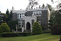
Wyncote features the Wyncote Historic District which is a US Historic district, added in October, 1986. It was made a historic district for its Architecture, Community Planning, and Development. The district covers over 100 acres, and 178 contributing buildings.

The Wyncote Historic District has a number of restored Victorian-era homes. The All Hallows Church (constructed 1896–1897) was designed by a firm founded by Philadelphia architect Frank Furness (Furness, Evans and Company). Wyncote also has a number of classical Philadelphia stone colonial revival homes; notable among them is Beechwood, designed in the school of Brognard Okie, the architect responsible for the reconstruction of Pennsbury Manor on the upper Delaware River, and Appleford in Villanova, Pennsylvania.

Wyncote Historic District

Transportation

Public transit

The Jenkintown-Wyncote station is one of the busiest in the SEPTA system. Jenkintown Platform.JPG
The Jenkintown–Wyncote station is one of the busiest in the SEPTA system.

Wyncote is served by SEPTA, through regional rail at the Jenkintown–Wyncote station. The building is a historic structure, dating back to its original use with the North Pennsylvania Railroad. Trains pass through regularly going south to Philadelphia or north to Bucks County. Wyncote is a 30-minute train ride from downtown Philadelphia. Wyncote is also served by SEPTA buses, in particular the 77 route, which connects Chestnut Hill to Mayfair, Philadelphia.

Roads

Wyncote is in a convenient location driving-wise; about a 25-minute drive to downtown Philadelphia, 2 hours from New York City, 2 hours to the Pocono Mountains, and 1.5 hours to the Jersey Shore, just to name a few accessible locations. The following are the most heavily traveled roads in Wyncote:


Climate

Wyncote has the climate of a typical Mid-Atlantic town. Summers are hot with highs averaging in the high 80s (°F), with lows being anywhere from the high 60s to the low 80s. Summers also see some days climb into the 90s, and even some that top the 100-degree mark. Spring and Fall are pleasant, with highs averaging in the mid 60s, and lows in the mid 40s. Winters are cold, with highs averaging around 40, and lows averaging in the high teens. The middle of winter occasionally sees a few days where highs do not rise above the teens, and lows fall into the single digits. The following is a chart of the average temperatures in Wyncote [7]

Climate data for Wyncote, Pennsylvania
MonthJanFebMarAprMayJunJulAugSepOctNovDecYear
Record high °F737388959610210210298888276102
Average high °F37425062728185847765544362.6
Average low °F18223241516267655643342342.8
Record low °F−11−3−11632344537302011−10−11
Average precipitation inches3.443.014.324.124.374.605.053.984.533.823.944.2349.41
Record high °C23233135363939393731282439
Average high °C36101722272929251812617.0
Average low °C−8−605111719181361−56.0
Record low °C−24−19−18−90173−1−7−12−23−24
Average precipitation mm8776110105111117128101115971001071,255
Source: The Weather Channel "The Weather Channel". The Weather Channel. Retrieved October 1, 2011.

Points of interest

Robinson park in Wyncote. The pond in the background typically freezes, and provides recreation for the locals. Wyncote Park.JPG
Robinson park in Wyncote. The pond in the background typically freezes, and provides recreation for the locals.
Thomas Williams Park TW3.JPG
Thomas Williams Park

Schools

Related Research Articles

<span class="mw-page-title-main">Montgomery County, Pennsylvania</span> County in Pennsylvania, United States

Montgomery County, colloquially referred to as Montco, is a county in the Commonwealth of Pennsylvania. It is the third-most populous county in Pennsylvania and the 73rd-most populous county in the United States. As of the 2020 census, the population of the county was 856,553, representing a 7.1% increase from the 799,884 residents counted in the 2010 census. Montgomery County is located adjacent to and northwest of Philadelphia. The county seat and largest city is Norristown. Montgomery County is geographically diverse, ranging from farms and open land in the extreme north of the county to densely populated suburban neighborhoods in the southern and central portions of the county.

<span class="mw-page-title-main">Bristol Township, Bucks County, Pennsylvania</span> Township in Pennsylvania, United States

Bristol Township is a township in Bucks County, Pennsylvania, United States. The population was 54,582 at the 2010 census, making it the 13th largest municipality in the state. Bristol Township, along with Bristol Borough, is a cultural hub for Lower Bucks County, hosting celebrations of African and Latino heritage. Parts of the township consist of the neighborhoods of Fairless Hills and Levittown. It is located within the Delaware Valley.

<span class="mw-page-title-main">Churchville, Pennsylvania</span> Census-designated place in Pennsylvania, United States

Churchville is a census-designated place (CDP) in Northampton Township, Bucks County, Pennsylvania, United States. The population was 4,128 at the 2010 census.

<span class="mw-page-title-main">Warminster Heights, Pennsylvania</span> Census-designated place in Pennsylvania, United States

Warminster Heights is a census-designated place and part of Warminster Township in Bucks County, Pennsylvania, United States. It is located near the eastern border of Hatboro in Montgomery County. The population was 4,124 at the 2010 census.

<span class="mw-page-title-main">Chesterbrook, Pennsylvania</span> Census-designated place in Pennsylvania, United States

Chesterbrook is a census-designated place (CDP) in Chester County, Pennsylvania, United States. It is located within the Philadelphia metropolitan area and just south of Valley Forge National Historical Park. The population was 4,589 at the 2010 census.

<span class="mw-page-title-main">Exton, Pennsylvania</span> Census-designated place in Pennsylvania, United States

Exton is a census-designated place (CDP) in West Whiteland Township in Chester County, Pennsylvania, United States. Its population was 5,622 at the 2020 census. The Exton Square Mall and Main Street at Exton are both located within Exton along with several other shopping centers, making Exton the major shopping district in Chester County.

<span class="mw-page-title-main">Paoli, Pennsylvania</span> Census-designated place in Pennsylvania, United States

Paoli is a census-designated place (CDP) in Chester County near Philadelphia, Pennsylvania, United States. It is situated in portions of two townships: Tredyffrin and Willistown. At the 2020 census, it had a total population of 6,002.

<span class="mw-page-title-main">Abington Township, Montgomery County, Pennsylvania</span> Township in Pennsylvania, United States

Abington Township is a township in Montgomery County, Pennsylvania, United States. It is adjacent to Philadelphia's northern fringe. The population was 58,502 as of the 2020 census, making it the second most populous township in Montgomery County after Lower Merion Township. The population density is 3603.3 per square mile (1,377/km2), making it the second most densely populated township in Montgomery County after Cheltenham Township.

<span class="mw-page-title-main">Glenside, Pennsylvania</span> Place in Pennsylvania, United States

Glenside is a census-designated place (CDP) located in Cheltenham Township and Abington Township in Montgomery County, Pennsylvania, United States. It borders Northwest Philadelphia. The population was 7,737 at the 2020 census on a land area of 1.3 square miles.

<span class="mw-page-title-main">Jenkintown, Pennsylvania</span> Borough in Pennsylvania, United States

Jenkintown is a borough in Montgomery County, Pennsylvania. It is approximately 10 miles (16 km) north of Center City Philadelphia.

<span class="mw-page-title-main">Lower Providence Township, Montgomery County, Pennsylvania</span> Township in Pennsylvania, United States

Lower Providence Township is a township in Montgomery County, Pennsylvania, United States. The township is located approximately 17 miles northwest of Philadelphia. The population was 25,625 at the 2020 census.

<span class="mw-page-title-main">Montgomeryville, Pennsylvania</span> Census-designated place in Pennsylvania, United States

Montgomeryville is a census-designated place (CDP) in Montgomery Township, Montgomery County, Pennsylvania, United States. The population was 12,624 at the 2010 census. According to a 2010 Forbes magazine/Yahoo.com survey, Montgomeryville ranks 5th in America's top 10 affordable suburbs. It is part of the North Penn Valley region that is centered on the borough of Lansdale.

<span class="mw-page-title-main">Rockledge, Pennsylvania</span> Borough in Pennsylvania, United States

Rockledge is a borough in Montgomery County, Pennsylvania, United States. The population was 2,638 as of the 2020 census. Rockledge is surrounded by Abington Township and the city of Philadelphia, and shares a ZIP code with Jenkintown.

<span class="mw-page-title-main">Springfield Township, Montgomery County, Pennsylvania</span> Township in Pennsylvania, United States

Springfield Township is a township in Montgomery County, Pennsylvania. The population was 20,993 in 2022 according the Census Bureau. It includes the villages of Wyndmoor, Erdenheim, Flourtown, and Oreland. The communities of Lafayette Hill, Fort Washington, Laverock, North Hills, Miquon, and Glenside are also situated partly inside the Township.

<span class="mw-page-title-main">Elkins Park, Pennsylvania</span> Unincorporated community in Montgomery County, Pennsylvania, United States

Elkins Park is an unincorporated community in Montgomery County, Pennsylvania, United States. It is split between Cheltenham and Abington Townships in the northern suburbs outside of Philadelphia, which it borders along Cheltenham Avenue roughly 7 miles (11 km) from Center City. The community is four station stops from Center City on Septa Regional Rail. It was listed as a census-designated place prior to the 2020 census.

<span class="mw-page-title-main">West Oak Lane, Philadelphia</span> Neighborhood of Philadelphia in Pennsylvania, United States

West Oak Lane is a neighborhood in the Northwest Philadelphia, Pennsylvania, United States. The neighborhood was developed primarily between the early 1920s and late 1930s, with the areas near to Cedarbrook constructed after World War II. At the northeast corner of Limekiln Pike and Washington Lane was the site of the Cedar Park Inn, a historic tavern built in the early 19th century, which was torn down sometime after 1931 as the neighborhood was being fully developed.

<span class="mw-page-title-main">Jenkintown–Wyncote station</span> Railway station in Pennsylvania, United States

Jenkintown–Wyncote station is a major SEPTA Regional Rail station along the SEPTA Main Line in Montgomery County, Pennsylvania. It is located at the intersection of Greenwood Avenue and West Avenue on the border of Jenkintown and the Wyncote neighborhood of Cheltenham Township, with a mailing address in Jenkintown. It is the ninth-busiest station in the regional rail system, and the fourth busiest outside Center City. Despite this, the station is not wheelchair accessible. SEPTA had plans to make the station wheelchair accessible by 2020, but these have not yet been completed.

<span class="mw-page-title-main">Cheltenham Township School District</span> School district in Pennsylvania

The Cheltenham Township School District is a public school district serving Cheltenham Township in Montgomery County, Pennsylvania. The district is one of the 500 public school districts of Pennsylvania. The District encompasses approximately 9 square miles (23 km2). According to 2000 federal census data, it served a resident population of 36,875. By 2010, the District's population declined to 36,000 people. In 2009, the district residents’ per capita income was $31,424, while the median family income was $76,792. In the Commonwealth, the median family income was $49,501 and the United States median family income was $49,445, in 2010. By 2013, the median household income in the United States rose to $52,100.

Cheltenham Avenue is a major east-west road in Southeastern Pennsylvania. It is served by many SEPTA bus routes, trolleys, regional rail, and subway. Cheltenham Avenue is an unsigned quadrant route t routes in Montgomery County, Pennsylvania. It also is a major borderline; it defines the border between Springfield and Cheltenham townships, and Cheltenham Township and the City of Philadelphia, with the latter also being the Montgomery County and Philadelphia County. A section of the road along the Philadelphia–Cheltenham border is part of PA Route 309.

<span class="mw-page-title-main">Cheltenham Township, Montgomery County, Pennsylvania</span> Place in Pennsylvania, United States

Cheltenham Township is a Home Rule Municipality and Township of the First Class located in the southeast corner of Montgomery County, Pennsylvania, United States. It borders the City of Philadelphia to the south and east, Abington Township and the borough of Jenkintown to the north, and Springfield Township to the west.

References