Mont Clare, Pennsylvania

Last updated

Mont Clare
formerly Quincyville
Village
Lock 60 2010-11-13.jpg
Schuylkill Canal Lock 60 in Mont Clare
Etymology: Mont Clare/Clair from poet Bayard Taylor
USA Pennsylvania location map.svg
Red pog.svg
Mont Clare
Location of Mont Clare in Pennsylvania
Coordinates: 40°08′10″N75°30′24″W / 40.13611°N 75.50667°W / 40.13611; -75.50667
CountryUnited States
StatePennsylvania
County Montgomery
Township Upper Providence
Population
 (2010) [1]
  Total1,483
Time zone UTC-5 (Eastern Standard Time)
  Summer (DST) UTC-4 (Eastern Daylight Time)
ZIP Code
19453
Area codes 484 and 610

Mont Clare is a village in Upper Providence Township, Montgomery County, Pennsylvania. The village is located on the left bank of the Schuylkill River opposite Phoenixville and Chester County. Mont Clare is at the site of the former Jacobs' ford. Mont Clare hosts the only functional lock and one of only two remaining watered stretches of the Schuylkill Canal. Mont Clare was the birthplace of the infamous outlaw Sundance Kid.

Contents

The village was originally named Quincyville and has also been spelled Quinzyville, Mont Clair, and Montclare.

History

Prior to the European colonization of the Americas, there was an aboriginal American encampment or village on the site, of the Unami speaking Lenni-Lenape tribe. [2] All but a few individuals had vacated the area by 1773. [3]

Colonial and Revolutionary War eras

The site's original English colonization was as part of the Duke of York's holdings. In 1681, King Charles II granted the land to William Penn, creating the Province of Pennsylvania. The site became part of Penn's Manor of Gilberts, as well as part of Philadelphia County. In 1729, Providence Township was created out of much of the Manor, including the site.

The earliest recorded resident of European descent on the site appears to have been Patrick Gordon, who settled in Providence Township, along the Schuylkill in what is now Mont Clare. This Gordon was Deputy Governor of the Province of Pennsylvania from 1726, until his death in 1736. [4]

In 1761, another Patrick Gordon, relation to Deputy Governor Gordon unknown, leased a "plantation" from the sons of William Penn. This Gordon lived in an improved cave in the hill below where the Mont Clare railroad station would be located over 100 years later. Newspaper accounts show him to be living in the vicinity as early as 1757. He was reportedly unmarried and owned female slaves which lived in the cave with him. Those newspaper notices show he also came into possession of his neighbor's livestock on occasion. [5]

In Colonial America, the ford drew traffic through Quincyville. Bean's History of Montgomery County Pennsylvania suggests Quincyville was the location of Joseph Richardson's 1766 licensed inn. [6]

The ford was used by American and British troops during the American Revolutionary War. In Fall 1777, Lord Cornwallis' troops forced a passage of the ford. This move ultimately led to the British taking Philadelphia. [5] Gordon's Cave became the site of a very minor American victory when a British squad tarried there to liberate a roasting goose and were captured by militia. [7]

In 1784, Philadelphia County was split and the village became part of the newly formed Montgomery County.

On December 3, 1785, 700 acres (280 ha) of land at what is now Mont Clare, were sold by John Penn and John Penn, Jr., grandsons of William Penn, to Quaker John Jacobs for £2,600. [5] The first Jacobs to live on the property was colonial Assemblyman and future Representative at the 2nd United States Congress, Israel Jacobs. [8]

In 1805, Providence Township was split along the Perkiomen Creek, leaving the village in the newly formed Upper Providence Township.

Canal era

In the 1820s, the construction of the Oakes Reach canal, of the "Schuylkill Navigation", through the village brought more commerce and traffic. The 3.5-mile (5.6 km) Oakes Reach started in Mont Clare, ran down past neighboring Port Providence, and reentered the river at Oaks. Black Rock Dam, Lock 60 and a house for its lock tender were built in Mont Clare. In the mid-20th century, the lower mile was filled in when the river was dredged, however the upper portion was kept watered at the insistence of Mont Clare and Port Providence residents who use it for recreation.

In the winter of 1843-1844, Joseph Whitaker, ironmaster and state legislator from Phoenixville, obtained a charter for the first Mont Clare Bridge. Starting in the summer of 1844, the bridge was constructed to replace the ford. [9] In 1846, Whitaker sold his interest in the Phoenix Iron Works and moved across the river to Quincyville to land he had purchased there. Whitaker built a dwelling and a steam saw mill. Whitaker's residence was named Mont Clare (or Montclair, see below) at the 1847 suggestion of poet Bayard Taylor, [10] [11] setting the stage for the future name of the village.

By 1859, Quincyville consisted of "an inn, store, steam saw mill, lumberyard, and seventeen houses. There was formerly an iron foundry and machine shop here, which ha[d] been converted to a paper mill". "There was also a post office here, which was discontinued in the spring of 1858." [12]

The post office reopened from 1861 to 1868, but with the name Mont Clare. [13] Through the 1870s, the village name transitioned from Quincyville to Mont Clare (see below).

Rail era

Between 1882 and 1884, the Pennsylvania Schuylkill Valley Railroad was completed between Philadelphia and Reading with a station in Mont Clare. [14] The line comes up from Philadelphia on the river bluff then turns out above the northern part of Mont Clare on a high viaduct that then crosses the Schuylkill River into Phoenixville. The line crosses what was the front yard of the Mont Clare estate house. Fortunately the house has an equal rear entryway, so they moved the driveway to the former back door. In 1900, the Pennsylvania Railroad (PRR) combined the line with five other subsidiaries to form the Schuylkill and Juniata Railroad. [15] In 1902, the PRR eliminated the subsidiaries and took direct ownership of the line. [14] In late 1906, an express train derailed in Mont Clare, narrowly avoiding plunging into the river and any loss of life. [16] PRR discontinued the Mont Clare station between 1955 and 1958. [17] [18] After the PRR successor, Penn Central's, failure and the takeover of its successor, Conrail, the line now belongs to Norfolk Southern, who used it for freight. After two years of no local use, the line was formally taken out of service at the end of 2007. [19] As of 2009 one rail has been observed to be disconnected just south of the Bridge Street(PA 29) overpass in Mont Clare. The line is part of the alignment in the moribund Schuylkill Valley Metro light rail proposal, and the more recent, and less ambitious, Green Line rail proposal. Both proposals would reestablish rail service from Mont Clare to Philadelphia, via Norristown and Paoli, respectively.

In 1886, the Mont Clare Post Office was reopened, although it took the name Montclare from 1895 to 1905. [13] The Post Office remained open until the decline of small post offices at the end of the 20th century. Eventually Mont Clare was assigned the ZIP Code 19453. At the end, the Post Office was located at the eastern corner of Bridge and Walnut Streets in a small storefront in an apartment building. The Mont Clare Post Office finally closed again near the turn of the 21st century. Village mail is delivered by the Phoenixville Post Office to the still active 19453 ZIP Code, as well as to the Phoenixville Post Office's own 19460 ZIP code area, which entirely surrounds 19453.

Mont Clare firehouse on Bridge Street in 2015 Mont Clare Fire House, Mont Clare, Pennsylvania.jpg
Mont Clare firehouse on Bridge Street in 2015

In 1900, the volunteer Mont Clare Fire Company was formed. Chartered in 1910, Company 55 celebrated their 100th anniversary in 2010. Besides traditional fire and rescue, they have water rescue units with boats and divers, reflecting the river and canal location of Mont Clare. [20] In 2012, under economic pressure from the township, the Company merged with the volunteer Oaks Fire Company to form the Black Rock Volunteer Fire Company, Montgomery County Station 99. [21] The Black Rock Company continued operations from the Mont Clare and Oaks fire houses for many years. Circa 2021 the firehouse signage and many vehicles were removed.

Village names

1906 Topographic Map of Mont Clare Montclare Topo 1906.jpg
1906 Topographic Map of Mont Clare

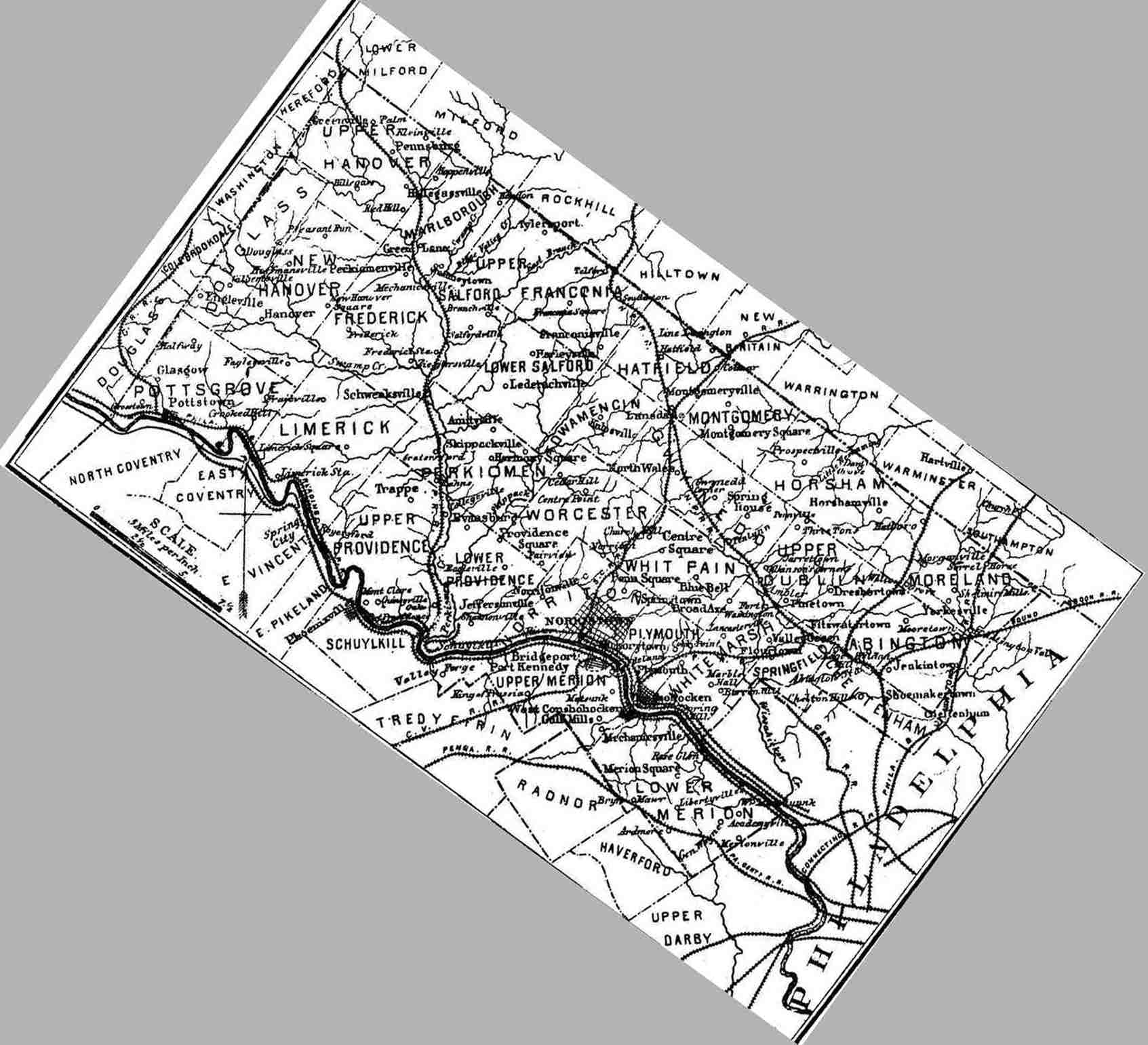
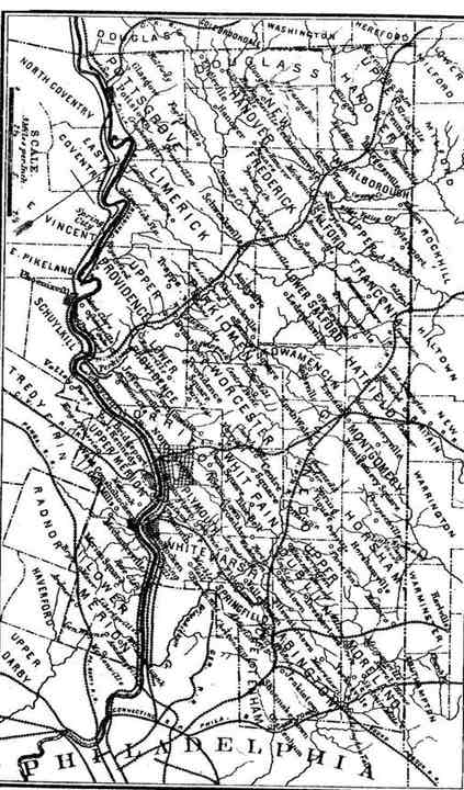
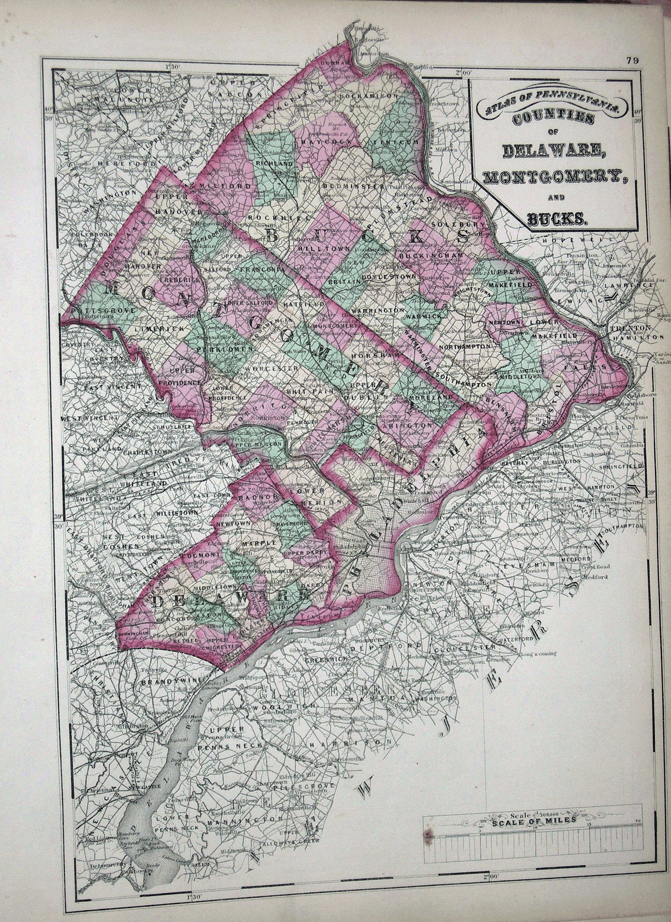
The village gradually changed its name from Quincyville to Mont Clare in the latter half of the 19th century, adopting the name of the estate of one of its most prominent residents. An early recognition was the naming of the reopened village Post Office as "Mont Clare" in 1861. In 1871 [22] and 1872 [23] atlases, the village is still labeled Quincyville, but Samuel W. Pennypacker refers to only Mont Clare in his 1872 Annals of Phoenixville and Its Vicinity. [24] An 1873 map shows it as Mont Clare. [25] In an 1877 atlas, it is shown as "Mt. Clare", [26] but that atlas' included history of Upper Providence refers to it as "Quincyville or Mont Clare" [27] and "Quincyville, perhaps better known as Mont Clare". [28] There is a story that the railroad dubbing the local station Montclair after Whitaker's estate was the source of the name change. [29] However the railroad and its Mont Clare station were constructed in the 1880s, well after the name appeared beyond the estate. Some references show both names simultaneously. The county map in Bean's 1884 history shows Mont Clare on the river and Quincyville as an adjacent village, inland. [30] Harley's 1881 history refers to both names individually in a list of Upper Providence villages. [31] [32] So while there is some possibility there were once two villages, the 1871 and 1877 atlases are the most detailed and both have insets detailing the property ownership of the same village on the river, but with the name changed. The 1895 atlas has no mention of Quincyville. [33]

The spellings of the village's names are the subject of some historical debate. There are several 1850s references to Quinzyville, including legislation [34] and Post Office lists. [35] [Note: A version of Bean's History on the web names it Quineyville, but this is a transcription error. [36] ] An 1895 article in The Philadelphia Inquirer claims that Bayard Taylor spelled the estate's name Mont Clair 48 years previously and notes the railroad company's using the spelling Mont Clare might be due to a "blind guess" that would be "near enough to pass". [10] Yet Pennypacker, who grew up in his grandfather's Mont Clare estate, consistently spells the name Mont Clare in his Annals of Phoenixville and attributes the estate's name to Bayard with that spelling. But Phoebe H. Gilkyson, a Whitaker great-granddaughter and later resident of the estate, refers to the house as Montclair in her papers. [37] In any event, Mont Clare is the modern spelling listed by both the USPS and GNIS, although the latter lists Montclare as a variant, as used on the map below. In 2012, GNIS added Quincyville, Quinzyville, and Mont Clair as additional variant names for Mont Clare, based on this article and its references.

Historical maps

Geography

Mont Clare is located inside a bend of the Schuylkill River, which forms the western and southern sides of the village. The village is at a historical ford and present day bridge. Originally settled between the river and a bluff, the village has expanded northeastward up the bluff along Bridge Street (Pennsylvania Route 29). The lower part of Mont Clare is in the river flood plain.

In 1995, Montgomery County designated the Mont Clare Cliffs and Ravines as a natural area "priority site". [38] Extending upriver from Mont Clare along the Schuylkill, this series of "steep cliffs and deeply etched ravines" are formed by the intersection of hard Lockatong Formation argillites with the river. [39]

Arts and culture

Mont Clare is primarily a residential community. The village has two churches: the Holy Archangel Michael Byzantine Catholic Church (locally known as St. Michael's) and the Otterbein United Methodist Church. A ten-minute walk across the bridge accesses downtown Phoenixville's restaurants, pubs, and theater.

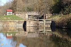
Mont Clare is the site of Lock 60, a fully restored and operating lock at the upstream end of the Oakes Reach of the Schuylkill Canal. The lock, tow path, the restored lock tender's house, and surrounding area form a park maintained by the Schuylkill Canal Association (SCA). The park is at the center of the "Schuylkill Navigation Canal, Oakes Reach Section" Historic District. The park includes a floating dock in the canal and a launch area on the river. This complements a portage trail, between the downstream end of the canal reach and the river. The river, portage, canal, and park form a 5-mile (8.0 km) canoe and kayak loop. St. Michael's has a large recreation area on the left bank of the canal, below the lock tender's house. SCA's annual summer Canal Day festival usually spans both parks. St. Michael's park also hosts the annual Ancient Order of Hibernians local Irish Festival. There is another park, Port Providence Park, on the canal between Mont Clare and Port Providence. Until 2020, Mont Clare was the western end of the contiguous Schuylkill River Trail (SRT) out of Philadelphia. The SRT now crosses the Mont Clare Bridge to continue westward through Phoenixville. Montgomery County plans to improve and extend the parallel Schuylkill East Trail on the left bank of the river, westward from Mont Clare, creating a major trail junction at Mont Clare. [40]

Joseph Whitaker's Mont Clare estate home still stands on the corner of Bridge and Grace Streets (Grace was Joseph's wife). The home is currently occupied by three generations of Whitaker descendants.

Notable people

By 1760, David Todd had settled near Mont Clare. [41] His sons, John; Robert; and Levi, were notable pioneers and helped found Lexington, Kentucky. Many of David's descendants were still living in the township in 1884. The most well known Todd descendants were Mary Todd Lincoln, wife of U. S. President Abraham Lincoln, and their son, Robert Todd Lincoln, Secretary of War under President Chester A. Arthur. [42]

In 1855, future Mennonite Church leader and publisher, John F. Funk, had his first job teaching in a one-room school house in Quincyville. [43]

The eventual 23rd Governor of Pennsylvania, Samuel W. Pennypacker, spent his boyhood at the Mont Clare estate of his maternal grandfather, Joseph Whitaker. [44] [45] In 1862, Pennypacker had his first professional job teaching in a one-room school house in the village. [46]

Mont Clare is the 1867 birthplace of the infamous outlaw Harry Alonzo "The Sundance Kid" Longabaugh. [47] The movie, Butch Cassidy and the Sundance Kid , erroneously states Sundance was born in New Jersey [48] (possibly due to confusion with Montclair, New Jersey). Sundance was born at 122 Jacobs Street. [49] [50] Sundance's mother's family, Place, was from Mont Clare, with one relative, Daniel Webster Place, marrying Mary E. Pennypacker in 1873. [51] Harry A. Place was the alias the Sundance Kid used when he married the woman known to history as Etta Place. Sundance's parents, Josiah and Annie (Place) Longabaugh, and his sisters Samanna and Emma, are buried in the nearby Morris Cemetery in Phoenixville.

Between 1882 and 1899, poet and local historian Christian Carmack Sanderson grew up living in Mont Clare and adjacent Port Providence. [52] The home at 205 Jacobs Street is referred to as "The Little Brick House" in his writings.

In 1916, the Mont Clare estate was occupied by Phoebe Hunter Gilkyson, a great granddaughter of Joseph Whitaker. Mrs. Gilkyson was a noted literary and social figure, whose poems and stories were published in Harper's, Scribner's and McClure's Magazines. She also wrote a newspaper column. Her husband Hamilton H. Gilkyson, Jr. was a local business and civic leader. [44] Phoebe's son, Terry Gilkyson was a songwriter and musician. Terry co-authored the chart topping Memories Are Made of This and wrote the Oscar nominated "The Bare Necessities" from the 1967 movie The Jungle Book .

Related Research Articles

<span class="mw-page-title-main">Phoenixville, Pennsylvania</span> Borough in Pennsylvania, United States

Phoenixville is a borough in Chester County, Pennsylvania, United States. It is located 28 miles (45 km) northwest of Philadelphia at the junction of French Creek and the Schuylkill River. It is in the Philadelphia metropolitan area. According to a 2022 estimate, the population was 19,354.

<span class="mw-page-title-main">Audubon, Pennsylvania</span> Census-designated place in Pennsylvania, United States

Audubon is a census-designated place (CDP) in Lower Providence Township, Montgomery County, Pennsylvania, United States. It was named for naturalist John James Audubon, who lived there as a young man. The population was 8,433 at the 2010 census.

<span class="mw-page-title-main">Upper Providence Township, Montgomery County, Pennsylvania</span> Township in Pennsylvania, United States

Upper Providence Township is a township in Montgomery County, Pennsylvania, United States. As of the 2010 census, the township population was 21,219.

<span class="mw-page-title-main">Samuel W. Pennypacker</span> Governor of Pennsylvania, Union United States Army soldier

Samuel Whitaker Pennypacker was an American politician and the 23rd governor of Pennsylvania, serving from 1903 to 1907. A judge assigned to Pennsylvania's Court of Common Pleas system prior to his election as governor, he also researched and wrote about Pennsylvania history.

<span class="mw-page-title-main">Schuylkill River</span> River in eastern Pennsylvania, United States

The Schuylkill River is a river in eastern Pennsylvania. It flows for 135 miles (217 km) from Pottsville southeast to Philadelphia, where it joins the Delaware River as one of its largest tributaries.

<span class="mw-page-title-main">Schuylkill Canal</span>

The Schuylkill Canal, or Schuylkill Navigation, was a system of interconnected canals and slack-water pools along the Schuylkill River in the U.S. state of Pennsylvania, built as a commercial waterway in the early 19th-century. Chartered in 1815, the navigation opened in 1825, to provide transportation and water power.

<span class="mw-page-title-main">Pennsylvania Route 29</span> State highway in Pennsylvania, US

Pennsylvania Route 29 is a 118-mile-long (190 km) north–south state highway that runs through most of eastern Pennsylvania.

Israel Jacobs was a colonial Pennsylvania Legislator and United States Representative from Pennsylvania's 3rd congressional district.

Fitzwater Station was a stop on the anti-slavery Underground Railroad. Located in Port Providence, Pennsylvania, United States, it is now a restaurant and bar. "The Fitz" overlooks the Schuylkill Canal.

Oaks is an unincorporated community located in Upper Providence Township, Montgomery County, Pennsylvania, United States. The community is 18 miles (30 km) northwest of Philadelphia and its boundaries are defined in large part by the village's position at the junction of Perkiomen Creek and the Schuylkill River.

<span class="mw-page-title-main">Schuylkill River Trail</span> Multi-use trail in Pennsylvania, United States

The Schuylkill River Trail is a multi-use trail along the banks of the Schuylkill River in southeastern Pennsylvania. Partially complete as of 2018, the trail is ultimately planned to run about 140 miles (230 km) from the river's headwaters in Schuylkill County to Fort Mifflin in Philadelphia.

<span class="mw-page-title-main">Pennsylvania Route 23</span> State highway in Pennsylvania, US

Pennsylvania Route 23 is an 81.14-mile-long (130.58 km) state highway in southeastern Pennsylvania. The route begins at PA 441 in Marietta and heads east to U.S. Route 1 at City Avenue on the border of Lower Merion Township and Philadelphia. PA 23 begins at Marietta in Lancaster County and continues east to Lancaster, where it passes through the city on a one-way pair of streets and intersects US 222 and US 30.

<span class="mw-page-title-main">Mont Clare Bridge</span> Bridge in Southeastern Pennsylvania, USA

The Mont Clare Bridge is a crossing of the Schuylkill River between Mont Clare and Phoenixville in Pennsylvania, USA. The bridge was also referred to as the Intercounty Bridge, as it connects Montgomery and Chester counties. The bridge abuts a shorter county bridge across the Schuylkill Canal and towpath on the Mont Clare side to complete the crossing. The crossing carries Bridge Street and the Schuylkill River Trail.

<span class="mw-page-title-main">Joseph Whitaker (industrialist)</span> American businessman and politician (1789–1870)

Joseph Whitaker was an American industrialist, landowner, and legislator in the Phoenixville and Mont Clare area of Pennsylvania, during the 19th century. He was a member of the Whitaker iron family.

<span class="mw-page-title-main">Schuylkill Canal Association</span>

The Schuylkill Canal Association (SCA) is a non-governmental organization that maintains the Oakes Reach and Lock #60 of the Schuylkill Canal as a public recreation area and historical site. Organized in 1982 as the Schuylkill Canal Advisory Board, the Association, in cooperation with Upper Providence Township, Montgomery County, and the Commonwealth of Pennsylvania, maintains the canal reach, associated structures, parks and trails. The area extends along the canal and left bank of the Schuylkill River, from Mont Clare past Port Providence. The area makes up a large part of the Schuylkill Navigation Canal, Oakes Reach Section Historic District (#88000462).

<span class="mw-page-title-main">Black Rock Tunnel</span>

The Black Rock Tunnel is an active rail road tunnel of the old Reading Railroad. The 1835 tunnel was the third rail tunnel constructed in the United States, and is the third oldest still in use. The tunnel is also notable as being the first for which shafts were sunk during construction. The tunnel is cut through a hill in Phoenixville, Pennsylvania, United States. The tunnel and line are now owned by Norfolk Southern as part of its Harrisburg Line.

<span class="mw-page-title-main">Birdsboro station (Reading Railroad)</span>

The Reading Company used two passenger railway stations in or near Birdsboro, Pennsylvania. The Philadelphia and Reading Railroad built a station on its Main Line in Exeter Township, on the opposite side of the Schuylkill River from Birdsboro. The Wilmington and Northern Railroad established a freight line to Birdsboro in 1870, but it was not until after its merger with the Reading Company that its passenger station was built in the borough.

<span class="mw-page-title-main">Schuylkill Friends Meeting House</span>

Schuylkill Friends Meeting House is a Quaker meeting house located on North Whitehorse Road in the Schuylkill Township section of Chester County, Pennsylvania, in the United States. This Meeting House is 2.5 miles west of the Valley Forge Post Office.

<span class="mw-page-title-main">Elijah F. Pennypacker</span> American politician and abolitionist (1804–1888)

Elijah Funk Pennypacker was a politician, abolitionist and station master in the Underground Railroad in the United States, in the years leading up to the American Civil War. He operated in Chester County, Pennsylvania. Pennypacker's home, White Horse Farm, was a safe house during the time that he participated in the Underground Railroad. As a station master in the Underground Railroad, Pennypacker reportedly aided hundreds of fugitive slaves in their escape to freedom, without any having been apprehended by authorities or by bounty hunters. He also served as a member of the Pennsylvania House of Representatives, representing Chester County from 1832 to 1833 and from 1835 to 1836.

Matthias Pennypacker was an American politician from Pennsylvania. He served as a member of the Pennsylvania House of Representatives, representing Chester County from 1827 to 1828 and in 1831.

References

  1. "2010 Demographic Profile". Archived from the original on February 13, 2020. Retrieved April 3, 2016.
  2. Pennypacker, Samuel Whitaker (1872). Annals of Phoenixville and Its Vicinity: From the Settlement to the Year 1871. Phoenixville, PA: Bavis & Pennypacker, printers. pp.  5–7.
  3. Ibid., p. 10.
  4. 1 2 Bean, Theodore W., ed. (1884). HISTORY OF MONTGOMERY COUNTY PENNSYLVANIA, ILLUSTRATED, 1884. Philadelphia: Everts & Peck. p. 1047.
  5. 1 2 3 Pennypacker, Samuel Whitaker; J. O. K. Robarts (1910) [c. 1880]. "The Story of Patrick Gordon". Historical Sketches: A Collection of Papers. Vol. IV. Norristown, PA: Historical Society of Montgomery County Pennsylvania. pp. 26–30. Retrieved August 8, 2009.
  6. Bean, p. 348
  7. Pennypacker, Annals of Phoenixville, p. 107
  8. Pennypacker, Annals of Phoenixville, p. 282
  9. Ibid., p. 175
  10. 1 2 From The Philadelphia Inquirer (December 6, 1895). "Named by Bayard Taylor". The New York Times . p. 2. Retrieved April 26, 2008.
  11. Pennypacker, Annals of Phoenixville, p. 144.
  12. Buck, William Joseph (1859). History of Montgomery County Within the Schuylkill Valley. Norristown: E. L. Acker. p.  101.
  13. 1 2 "Post Offices - Pennsylvania - Montgomery County" . Retrieved October 9, 2010.
  14. 1 2 "Corporate Genealogy - The Pennsylvania Railroad". Archived from the original on December 29, 2007. Retrieved March 16, 2008.
  15. Burgess, George H.; Kennedy, Miles C. (1949). "Chapter L: Simplification of Corporate Structure" (PDF). The Pennsylvania Railroad Company 1845-1945. Philadelphia: The Pennsylvania Railroad Company. p. 509. Retrieved June 27, 2010.
  16. "In Nearby Counties". Reading Eagle. Reading, PA. November 19, 1906. p. 2. Retrieved July 3, 2015.
  17. "The Pennsylvania Railroad - Regional Map" (PDF). November 1955. Retrieved June 27, 2010.
  18. "Philadelphia Region/Philadelphia District Map". Archived from the original on July 11, 2012. Retrieved November 29, 2008.
  19. "Surface transportation Board Discontinuance of Service Exemption" . Retrieved February 20, 2010.
  20. "Mont Clare Fire Co. - About Us". Archived from the original on September 14, 2010. Retrieved November 7, 2010.
  21. "Black Rock Volunteer Fire Company" . Retrieved August 11, 2013.
  22. 1 2 Hopkins, G. M. (1871). Atlas of the County of Montgomery and the state of Pennsylvania. Archived from the original on July 8, 2008. Retrieved April 26, 2008.
  23. Walling, Henry F.; O. W. Gray (1872). New Topographical Atlas of the State of Pennsylvania. Philadelphia: Stedman, Brown & Lyon. p. 79. Retrieved March 15, 2009.
  24. Pennypacker, Annals of Phoenixville, pp. various.
  25. "Old Maps - Historical Society of the Phoenixville Area" . Retrieved January 27, 2012.
  26. 1 2 Scott, J. D. (1877). Combination Atlas of Montgomery County. pp. 56–57. Archived from the original on July 8, 2008. Retrieved April 26, 2008.
  27. Ibid., p. 27.
  28. Ibid., p. 28.
  29. "The Schuylkill Canal, or Oakes Reach" . Retrieved March 15, 2008.
  30. Bean, p. 1.
  31. Harley, J. K. (1891) [1881]. A History and Geography of Montgomery County, Pa., together with County and Township Government. Philadelphia. p.  67.{{cite book}}: CS1 maint: location missing publisher (link)
  32. While the 1891 Revised Edition of Harley was used, it does not list the Penna. RR line in Upper Providence, so it is referred to here by the original 1881 publication date.
  33. "1895 Atlas Pennsylvania - Q-Rh" . Retrieved August 29, 2010.
  34. United States; George Minot; George P. Sanger (1850). The Statutes at Large and Treaties of the United States of America. Dennis. p. 397. Retrieved March 28, 2009.
  35. Tompkins Lech, Daniel D. (1857). List of post offices in the United States. John C. Rives. p. 118. Retrieved March 28, 2009.
  36. "BEAN'S HISTORY OF MONTGOMERY COUNTY, PENNSYLVANIA, CHAPTER LXXII. UPPER PROVIDENCE TOWNSHIP". pp. 1057–8. Retrieved July 7, 2009.
  37. Correspondence with Neal Gilkyson Thorpe, Phoebe's daughter, 28 September 2010.
  38. Rhoads, Anne F.; Timothy A. Block (June 30, 2007). "Montgomery County, Pennsylvania, Natural Areas Inventory Update" (PDF). p. 219. Archived from the original (PDF) on July 18, 2011. Retrieved April 11, 2009.
  39. Ibid., p. 212.
  40. "MONTCO HAS PLAN TO BUILD 166 MILES OF BICYCLE TRAILS".
  41. "UPPER AND LOWER PROVIDENCE TWP MAP" . Retrieved March 15, 2009.
  42. Bean, p. 1048.
  43. "JOURNAL OF THE QUINCYVILLE SCHOOL" (PDF). Archived from the original (PDF) on June 4, 2011. Retrieved March 14, 2009.
  44. 1 2 Hunsicker, Clifton Swenk (1923). Montgomery County, Pennsylvania, a History. Vol. 3. New York: Lewis Historical Pub. Co. pp. 544–5. Retrieved April 5, 2009.
  45. Pennypacker, Samuel Whitaker (1918). The Autobiography of a Pennsylvanian. Philadelphia: John C. Winston Co. p.  61 . Retrieved April 12, 2009.
  46. "SAMUEL W. PENNYPACKER PAPERS" . Retrieved October 8, 2010.
  47. "The Schuylkill Canal". Archived from the original on February 8, 2007. Retrieved March 7, 2007.
  48. "Goofs for Butch Cassidy and the Sundance Kid". IMDb . Retrieved May 20, 2009.
  49. "Harry A. Longabaugh, alias the Sundance Kid" . Retrieved April 4, 2016.
  50. "Find Pennsylvania Hometowns Here" . Retrieved March 15, 2008.
  51. "Descendants of "Hendrick Pennebecker" - Sixth Generation". Archived from the original on November 10, 2006. Retrieved January 1, 2010.
  52. "Timeline: The Life & Times of Chris Sanderson". Archived from the original on February 27, 2010. Retrieved November 9, 2009.