Upper Moreland Township, Pennsylvania

Last updated

Upper Moreland Township
Upper Moreland High School Montco PA.jpg
Nickname: 
golden bears
Motto(s): 
live strong and be golden
Upper Moreland Township Montgomery County.png
Location of Upper Moreland Township in Montgomery County
USA Pennsylvania location map.svg
Red pog.svg
Upper Moreland Township
Location of Upper Moreland Township in Pennsylvania
Usa edcp location map.svg
Red pog.svg
Upper Moreland Township
Upper Moreland Township (the United States)
Coordinates: 40°09′26″N75°06′07″W / 40.15722°N 75.10194°W / 40.15722; -75.10194
CountryUnited States
State Pennsylvania
County Montgomery
Government
  Type Council-manager
Area
[1]
  Total7.98 sq mi (20.7 km2)
  Land7.97 sq mi (20.6 km2)
  Water0.01 sq mi (0.03 km2)
Elevation
177 ft (54 m)
Population
 (2010) [2]
  Total24,015
  Estimate 
(2016) [3]
24,210
  Density3,000/sq mi (1,200/km2)
Time zone UTC-5 (EST)
  Summer (DST) UTC-4 (EDT)
ZIP Codes
19006, 19040, 19090
Area code(s) 215, 267 and 445
FIPS code 42-091-79176
Website www.uppermoreland.org

Upper Moreland Township is a township in Montgomery County, Pennsylvania. The population was 24,015 at the 2010 census. Upper Moreland Township is primarily a residential community with distinctive neighborhoods that are complemented by several thriving business, industrial, and commercial districts.

Contents

Geography

According to the U.S. Census Bureau, the township has a total area of 7.5 square miles (19 km2), all land. Upper Moreland is part of the Philadelphia Metropolitan Area and is approximately 15 miles (24 km) north of Center City Philadelphia. The township is bordered by the Montgomery County communities of Hatboro, Horsham, Upper Dublin, Abington, Bryn Athyn, and Lower Moreland. while Bucks County lies to the north.

Demographics

Historical population
CensusPop.Note
1930 3,989
1940 5,10327.9%
1950 8,93675.1%
1960 21,032135.4%
1970 24,86618.2%
1980 25,8744.1%
1990 25,313−2.2%
2000 24,993−1.3%
2010 24,015−3.9%
2020 26,1168.7%
U.S. Decennial Census [4] [5]

At the 2010 census, the township was 85.2% White, 5.1% Black or African American, 0.2% Native American, 4.4% Asian, 0.1% Native Hawaiian and Other Pacific Islander, 1.3% were Some Other Race, and 1.9% were two or more races. 3.6% of the population were of Hispanic or Latino ancestry. [6]

At the 2000 census, [7] there were 24,993 people, 10,120 households and 6,638 families residing in the township. The population density was 3,139.6 per square mile (1,212.2/km2). There were 10,403 housing units at an average density of 1,306.8 per square mile (504.6/km2). The racial make-up was 90.72% White, 4.36% African American, 0.10% Native American, 3.17% Asian, 0.02% Pacific Islander, 0.58% from other races, and 1.04% from two or more races. Hispanic or Latino of any race were 1.73% of the population.

There were 10,120 households, out of which 28.3% had children under the age of 18 living with them, 53.4% were married couples living together, 9.1% had a female householder with no husband present, and 34.4% were non-families. 28.7% of all households were made up of individuals, and 12.0% had someone living alone who was 65 years of age or older. The average household size was 2.40 and the average family size was 3.00.

22.1% of the population were under the age of 18, 6.9% from 18 to 24, 31.3% from 25 to 44, 21.4% from 45 to 64, and 18.3% who were 65 years of age or older. The median age was 39 years. For every 100 females, there were 91.8 males. For every 100 females age 18 and over, there were 88.0 males.

The median household income was $50,454 and the median family income was $61,143. Males had a median income of $41,697 and females $31,963. The per capita income was $25,382. About 3.0% of families and 4.9% of the population were below the poverty line, including 4.1% of those under age 18 and 5.3% of those age 65 or over.

History

William Penn presented the tract of land around present day Upper Moreland Township to Nicholas More in 1682. At the time, the area was referred to as the "Manor of Mooreland". Moreland Township was first used to describe the tract in the 18th century but the current boundaries were not fixed until 1916 when a line was drawn through the Pennypack Creek and two municipalities were created: Upper and Lower Moreland Townships. In 1930, Upper Moreland Township was formally organized as a First Class Township.

Government

Upper Moreland Township municipal building Upper Moreland Township municipal building.jpg
Upper Moreland Township municipal building
Presidential elections results [8]
Year Republican Democratic
2020 40.0% 6,04558.3%8,840
2016 40.7% 5,27553.8%6,973
2012 43.6% 5,34155.0%6,729
2008 41.3% 5,32857.8%7,448
2004 45.6% 5,81053.9%6,861
2000 46.0% 5,05851.1%5,627
1996 43.1% 4,31745.1%4,517
1992 41.7%4,79638.7% 4,451

Upper Moreland's governmental structure and powers are derived from the laws of the Commonwealth of Pennsylvania. Upper Moreland's seven member governing body, the Board of Commissioners, is composed of representatives elected from each of the Township's seven wards to serve a four-year term. The daily operations of the municipality are administered by the Township Manager, Assistant Township Manager, Chief of Police, and Directors of Emergency Services, Code Enforcement, Public Works, Parks and Recreation, and Finance. These positions, as well as the Township Solicitor and Township Engineer, are appointed by the Board of Commissioners. [9] The only other elected official is the Township Treasurer.

Township Commissioners: [10]

Ward 1 - Nicholas Scull
Ward 2 - Kevin C. Spearing
Ward 3 - Charles Whiting
Ward 4 - Anthony S. Prousi
Ward 5 - Clifton (Kip) McFatridge, President
Ward 6 - R. Samuel Valenza
Ward 7 - Cheryl Lockard, Vice President

Township Treasurer: Joseph J. Olszak [11]

Economy

The township states that the proximity of the Pennsylvania Turnpike attracts firms to the township. [12]

China Airlines operates the Philadelphia Mini Office (Chinese: 費城營業所 Fèichéng Yíngyèsuǒ [13] ) in Building 39G at 2300 Computer Avenue in the Willow Grove CDP and in Upper Moreland Township. [14]

Infrastructure

Transportation

View east along the Pennsylvania Turnpike/I-276 in Upper Moreland Township 2022-10-11 15 36 16 View east along Interstate 276 (Pennsylvania Turnpike Delaware River Extension) from the overpass for Pennsylvania State Route 63 (Welsh Road) in Upper Moreland Township, Montgomery County, Pennsylvania.jpg
View east along the Pennsylvania Turnpike/I-276 in Upper Moreland Township

As of 2018 there were 85.02 miles (136.83 km) of public roads in Upper Moreland Township, of which 4.00 miles (6.44 km) were maintained by the Pennsylvania Turnpike Commission (PTC), 15.51 miles (24.96 km) were maintained by the Pennsylvania Department of Transportation (PennDOT) and 65.51 miles (105.43 km) were maintained by the township. [15]

Major highways serving Upper Moreland Township include the east–west Pennsylvania Turnpike (Interstate 276), with the Willow Grove Interchange located within the township, and Pennsylvania Route 611 (Easton Road), which links the area with Doylestown to the north and Philadelphia to the south and connects to the Pennsylvania Turnpike at the Willow Grove Interchange. Other important roadways in the township are Pennsylvania Route 263 (York Road), Pennsylvania Route 63 (Moreland Road), County Line Road, Davisville Road, Byberry Road, Fitzwatertown Road, Terwood Road and Blair Mill Road. [16]

A SEPTA Regional Rail train on the Warminster Line stops at the Willow Grove station in Upper Moreland Township Willow Grove PA SEPTA station May 2016.jpg
A SEPTA Regional Rail train on the Warminster Line stops at the Willow Grove station in Upper Moreland Township

Commuter rail and bus services within Upper Moreland Township are provided by the Southeastern Pennsylvania Transportation Authority (SEPTA). The Warminster Line of SEPTA Regional Rail stops at the Willow Grove station within the township, running between Warminster Township and Center City Philadelphia. Multiple SEPTA bus routes serve the township, providing access to business parks and shopping centers and connecting to Philadelphia and other suburbs. Bus routes serving Upper Moreland Township include SEPTA City Bus Routes 22 , 55 , 80 , 310, and 311 and SEPTA Suburban Bus Route 95. [17]

Norfolk Southern Railway's Morrisville Line freight railroad line passes through Upper Moreland Township, running parallel to the south of the Pennsylvania Turnpike. [16] [18]

Utilities

Electricity and natural gas in Upper Moreland Township is provided by PECO Energy Company, a subsidiary of Exelon. [19] Water in the township is provided by Aqua Pennsylvania, a subsidiary of Aqua America. [20] The Upper Moreland-Hatboro Joint Sewer Authority provides sewage service to Upper Moreland Township along with neighboring Hatboro. [21] The Upper Moreland Township Public Works Department provides trash collection and recycling to the township. [22] Cable, telephone, and internet service to the area is provided by Xfinity and Verizon. Upper Moreland Township is served by area codes 215, 267, and 445. [23]

Health care

Jefferson Health–Abington operates the Jefferson Health–Willow Grove (formerly Abington Health Center–Willow Grove) health center in the Willow Grove section of the township. The health center, which was founded in 1983, consists of four buildings and offers outpatient hospital services including healthcare programs, medical and administrative offices, and conference and educational facilities. [24]

Education

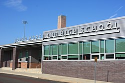
Upper Moreland Township is served by the Upper Moreland School District. The district consists of Upper Moreland Primary School for grades K-2, Upper Moreland Intermediate School for grades 3–5, Upper Moreland Middle School for grades 6–8, and Upper Moreland High School for grades 9-12.

The area Catholic school is Queen of Angels Regional Catholic School in Willow Grove and Upper Moreland Township, Pennsylvania. Queen of Angels was formed in 2012 by the merger of St. David in Willow Grove and Our Lady Help of Christians in Abington. [25]

Related Research Articles

<span class="mw-page-title-main">Montgomery County, Pennsylvania</span> County in Pennsylvania, United States

Montgomery County, colloquially referred to as Montco, is a county in the Commonwealth of Pennsylvania. As of the 2020 census, the population of the county was 856,553, making it the third-most populous county in Pennsylvania after Philadelphia and Allegheny counties.

<span class="mw-page-title-main">Upper Southampton Township, Pennsylvania</span> Township in Pennsylvania, United States

Upper Southampton Township is a township in Bucks County, Pennsylvania, United States. The population was 15,152 at the 2010 census.

<span class="mw-page-title-main">Warminster Township, Pennsylvania</span> Township in Pennsylvania, United States

Warminster Township, also referred to as Warminster, is located in Bucks County, Pennsylvania, United States. It was formally established in 1711. The township is 13.7 miles north of Philadelphia and had a population of 33,603 according to the 2020 U.S. census.

<span class="mw-page-title-main">Warminster Heights, Pennsylvania</span> Census-designated place in Pennsylvania, United States

Warminster Heights is a census-designated place and part of Warminster Township in Bucks County, Pennsylvania, United States. It is located near the eastern border of Hatboro in Montgomery County. The population was 4,124 at the 2010 census.

<span class="mw-page-title-main">Warrington Township, Bucks County, Pennsylvania</span> Township in Pennsylvania, United States

Warrington Township is a township in Bucks County, Pennsylvania, United States. Warrington Township is a northern suburb of Philadelphia. The population was 25,639 at the 2020 census.

<span class="mw-page-title-main">Abington Township, Montgomery County, Pennsylvania</span> Township in Pennsylvania, United States

Abington Township is a township in Montgomery County, Pennsylvania, United States. It is adjacent to Philadelphia's northern fringe. The population was 58,502 as of the 2020 census, making it the second most populous township in Montgomery County after Lower Merion Township. The population density is 3603.3 per square mile (1,377/km2), making it the second most densely populated township in Montgomery County after Cheltenham Township.

<span class="mw-page-title-main">Hatboro, Pennsylvania</span> Borough in Pennsylvania, United States

Hatboro is a borough in Montgomery County, Pennsylvania, United States. The population was 8,238 at the 2020 census.

<span class="mw-page-title-main">Horsham, Pennsylvania</span> Census-designated place in Pennsylvania, United States

Horsham is a census place in Horsham Township, Montgomery County, Pennsylvania, United States. The population was 15,193 at the 2020 census. It is home to the Biddle Air National Guard Base at the former site of Naval Air Station Joint Reserve Base Willow Grove.

<span class="mw-page-title-main">Horsham Township, Pennsylvania</span> Home rule municipality in Pennsylvania, United States

Horsham Township is a home rule municipality in Montgomery County, Pennsylvania. It is located ten miles north of Center City Philadelphia. The township, incorporated in 1717, is one of the oldest original municipalities in Montgomery County. Although it retains the word "Township" in its official name, it has been governed by a Home Rule Charter since 1975 and is therefore not subject to the Pennsylvania Township Code. The population was 26,564 at the time of the 2020 census.

<span class="mw-page-title-main">Jenkintown, Pennsylvania</span> Borough in Pennsylvania, United States

Jenkintown is a borough in Montgomery County, Pennsylvania. It is approximately 10 miles (16 km) north of Center City Philadelphia.

<span class="mw-page-title-main">Lower Moreland Township, Pennsylvania</span> Township in Pennsylvania, United States

Lower Moreland Township is a township in Montgomery County, Pennsylvania, United States. The population was 13,917 at the 2020 census.

<span class="mw-page-title-main">Springfield Township, Montgomery County, Pennsylvania</span> Township in Pennsylvania, United States

Springfield Township is a township in Montgomery County, Pennsylvania. The population was 20,993 in 2022 according the Census Bureau. It includes the villages of Wyndmoor, Erdenheim, Flourtown, and Oreland. The communities of Lafayette Hill, Fort Washington, Laverock, North Hills, Miquon, and Glenside are also situated partly inside the Township.

<span class="mw-page-title-main">Upper Dublin Township, Pennsylvania</span> Township in Pennsylvania, United States

Upper Dublin Township is a township in Montgomery County, Pennsylvania, United States. The population was 25,569 at the 2010 census. Until the 1950s, Upper Dublin was mostly farmland and open space, but transitioned to a residential suburb during the postwar population boom. The population went from just over 6,000 residents in the 1950s to just under 20,000 by 1970. Today, Upper Dublin is mostly spread-out development housing, and has the fourth highest median income in Montgomery County.

<span class="mw-page-title-main">Whitemarsh Township, Pennsylvania</span> Home rule municipality in Pennsylvania, United States

Whitemarsh Township is a Home rule municipality in Montgomery County, Pennsylvania. It retains its former classification of "Township" in its official name despite being a home rule municipality. The population was 17,349 at the 2010 census. Whitemarsh is adjacent to the neighborhood of Andorra in the Roxborough section of Philadelphia, and is bordered in Montgomery County by Springfield, Upper Dublin, Whitpain, and Plymouth townships, Conshohocken, and the Schuylkill River, which separates it from Lower Merion Township.

<span class="mw-page-title-main">Willow Grove, Pennsylvania</span> Census-designated place in Pennsylvania, United States

Willow Grove is a census-designated place (CDP) in Montgomery County, Pennsylvania, United States. A community in Philadelphia's northern suburbs, the population was 13,730 at the 2020 census. It is located in Upper Dublin Township, Abington Township and Upper Moreland Township. Willow Grove was once known for Willow Grove Park, an amusement park that was open from 1896 to 1976, now the site of Willow Grove Park Mall. Willow Grove is considered an edge city of Philadelphia, with large amounts of retail and office space.

<span class="mw-page-title-main">Pennsylvania Route 263</span> North–south state highway located in southeast Pennsylvania

Pennsylvania Route 263 (PA 263) is a north–south state highway located in southeast Pennsylvania. The southern terminus of the route is at PA 611 in Willow Grove, Montgomery County. The northern terminus is at the Centre Bridge–Stockton Bridge over the Delaware River in Centre Bridge, Bucks County, where the road continues into Stockton, New Jersey, as Bridge Street to an intersection with Route 29. PA 263 follows the routing of Old York Road, a historic road that connected Philadelphia to New York City, and carries the name York Road from the southern terminus to Lahaska and Upper York Road north of there. From Willow Grove to Buckingham, PA 263 runs mostly through suburban areas as a four-lane road, passing through Hatboro, Warminster, and Jamison. The route forms a concurrency with U.S. Route 202 (US 202) in Buckingham and narrows to a two-lane road, splitting with that route in Lahaska. From here, the route continues through rural areas to Centre Bridge.

<span class="mw-page-title-main">Upper Moreland School District</span> School district in Pennsylvania, United States

Upper Moreland School District is located in Upper Moreland Township, Montgomery County in the northern suburbs of Philadelphia, Pennsylvania. The Township has a general population of 25,000 residents who are served by the post offices of Willow Grove, Hatboro, and Huntingdon Valley, although due to postal and municipal boundaries, many students served by the Hatboro post office attend Hatboro-Horsham School District, while others served by the Huntingdon Valley post office attend Lower Moreland schools.

<span class="mw-page-title-main">Pennsylvania Route 63</span> 37.4-mile-long (60.2 km) state highway located in Pennsylvania

Pennsylvania Route 63 (PA 63) is a 37.4-mile-long (60.2 km) state highway located in the Philadelphia, Pennsylvania, area. The western terminus of the route is at PA 29 in Green Lane, Montgomery County. The eastern terminus is at Interstate 95 (I-95) in Bensalem Township, Bucks County. PA 63 runs northwest to southeast for most of its length. The route heads through a mix of suburban and rural areas of northern Montgomery County as a two-lane road, passing through Harleysville, before coming to an interchange with I-476 in Kulpsville. From this point, PA 63 continues through predominantly suburban areas of eastern Montgomery County as a two- to four-lane road, passing through Lansdale, Maple Glen, Willow Grove, and Huntingdon Valley. Upon entering Northeast Philadelphia, the route follows Red Lion Road and U.S. Route 1 (US 1) before heading southeast on a freeway called Woodhaven Road to I-95.

<span class="mw-page-title-main">Willow Grove Park Mall</span> Shopping mall in Willow Grove, Pennsylvania, United States

Willow Grove Park Mall is a three-story shopping mall located in the community of Willow Grove in Abington Township, Pennsylvania at the intersection of Easton Road and Moreland Road in the Philadelphia suburbs. The Willow Grove Park Mall contains over 120 stores - with Bloomingdale's, Primark, Macy's, Nordstrom Rack, and Tilted 10 as anchor stores - along with several restaurants including The Cheesecake Factory, TGI Fridays, and Yard House. It is owned by Pennsylvania Real Estate Investment Trust (PREIT) and is the third most profitable mall in the Philadelphia area. The mall features a carousel, scenic elevator, and formerly featured a fountain. In October, the fountain was illuminated pink for Breast Cancer Awareness Month.

<span class="mw-page-title-main">Upper Moreland High School</span> Public school

Upper Moreland High School is a comprehensive public high school, serving grades 9–12, located in Willow Grove, Pennsylvania, about fifteen miles outside of Philadelphia. It is the only high school in the Upper Moreland School District, which includes parts of the Huntingdon Valley, Hatboro, and Willow Grove ZIP codes in Upper Moreland Township. Its primary feeder school is Upper Moreland Middle School, and routinely sends graduates to colleges and universities in the United States and worldwide.

References

  1. "2016 U.S. Gazetteer Files". United States Census Bureau. Retrieved August 14, 2017.
  2. "U.S. Census website". United States Census Bureau . Retrieved January 7, 2016.
  3. "Population and Housing Unit Estimates" . Retrieved June 9, 2017.
  4. "Census of Population and Housing". Census.gov. Retrieved June 4, 2016.
  5. "Census 2020".
  6. Census 2010: Pennsylvania. Usatoday.Com. Retrieved on 2013-07-21.
  7. "U.S. Census website". United States Census Bureau . Retrieved January 31, 2008.
  8. "Montgomery County Election Results". Montgomery County, Pennsylvania. Retrieved January 16, 2017.
  9. http://uppermoreland.org/information/about.aspx [ dead link ]
  10. "About the Board of Commissioners". Upper Moreland Township. Retrieved January 9, 2022.
  11. "Administration". Upper Moreland Township. Retrieved January 9, 2022.
  12. "About Our Township". Upper Moreland Township, Pennsylvania. Retrieved January 25, 2009.
  13. "北美洲地區 Archived 2014-12-17 at the Wayback Machine ." China Airlines. Retrieved April 24, 2010
  14. "Branch Offices North America" Archived 2011-11-28 at the Wayback Machine , China Airlines. Retrieved January 25, 2009.
    - "Willow Grove CDP" [ permanent dead link ], U.S. Census Bureau. Retrieved January 25, 2009.
    "Maps-Township-Buildings", Upper Moreland Township, Pennsylvania. Retrieved January 25, 2009.
  15. "Upper Moreland Township map" (PDF). PennDOT. Retrieved March 10, 2023.
  16. 1 2 Montgomery County, Pennsylvania Highway Map (PDF) (Map). PennDOT. 2015. Retrieved January 12, 2016.
  17. SEPTA Official Transit & Street Map Suburban (PDF) (Map). SEPTA. Retrieved May 2, 2016.
  18. Norfolk Southern Harrisburg Region Timetable 1, August 4, 2008
  19. "PECO: Company Information". PECO Energy Company. Retrieved January 29, 2017.
    - "Electric Service Tariff" (PDF). PECO Energy Company. July 17, 2017. p. 4. Retrieved October 10, 2017.
    - "Gas Service Tariff" (PDF). PECO Energy Company. August 30, 2017. p. 2. Retrieved October 10, 2017.
  20. "Rates and Rules Governing the Distribution of Water" (PDF). Aqua Pennsylvania. March 11, 2013. p. 3. Retrieved October 11, 2017.
  21. "About Us". Upper Moreland-Hatboro Joint Sewer Authority. Retrieved January 29, 2017.
  22. "Trash Regulations". Upper Moreland Township. Retrieved October 11, 2017.
    "Recycling Regulations". Upper Moreland Township. Retrieved October 11, 2017.
  23. Area Code 215 and 267 Map (PDF) (Map). Pennsylvania Public Utility Commission . Retrieved June 22, 2011.
  24. "Abington Health Center-Willow Grove Guide to Services". Abington-Jefferson Health. Retrieved February 18, 2018.
  25. "2012 Catholic grade school consolidations/closings". Catholicphilly.com. July 15, 2012. Retrieved April 22, 2020.