Roslyn, Pennsylvania

Last updated

Roslyn
Roslyn PA 01.JPG
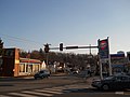
Bradfield Road in Roslyn, January 2013
USA Pennsylvania location map.svg
Red pog.svg
Roslyn
Location of Roslyn in Pennsylvania
Coordinates: 40°07′54″N75°08′16″W / 40.13167°N 75.13778°W / 40.13167; -75.13778
CountryUnited States
StatePennsylvania
County Montgomery
Township Abington
Population
 (2020)
  Total9,525
Time zone UTC-5 (EST)
  Summer (DST) UTC-4 (EDT)
ZIP Code
19001
Area code(s) 215, 267 and 445
FIPS code 42-66256
GNIS feature ID1193217 [1]
Website Official website

Roslyn is an unincorporated community in Abington Township, Montgomery County, Pennsylvania, United States. Originally called Hillside, the name Roslyn came from rose gardens that once grew there. [2]

The first known person of European descent to settle the area was John Tyson, who bought a tract of land here in 1717. He built lime kilns to turn the abundant local limestone into quicklime, starting an industry that operated into the late 20th century. [2]

The first rail connection to Roslyn was built by the North East Pennsylvania Railroad in 1872. [3] Today's railroad station, which replaced the original in the late 1970s, is on SEPTA's Warminster Line. The location of the train station in Roslyn is at the intersection of Susquehanna Road and Easton Road. [4]

The community is home to Roslyn Elementary School, one of the seven public elementary schools that make up Abington School District. St. John of the Cross Elementary, a parochial school, closed in 2010, merging with Queen of Peace in neighboring Ardsley, PA forming Good Shepherd Catholic Regional Elementary School. [5]

The headwaters for Sandy Run, a tributary of the Wissahickon Creek, are located in Roslyn. As of the 2020 United States census the population was 9,525. [6]

Related Research Articles

<span class="mw-page-title-main">Montgomery County, Pennsylvania</span> County in Pennsylvania, United States

Montgomery County, colloquially referred to as Montco, is a county in the Commonwealth of Pennsylvania. As of the 2020 census, the population of the county was 856,553, making it the third-most populous county in Pennsylvania after Philadelphia and Allegheny counties. The county is part of the Southeast Pennsylvania region of the state.

<span class="mw-page-title-main">Warminster Township, Pennsylvania</span> Township in Pennsylvania, United States

Warminster Township, also referred to as Warminster, is located in Bucks County, Pennsylvania, United States. It was formally established in 1711. The township is 13.7 miles north of Philadelphia and had a population of 33,603 according to the 2020 U.S. census.

<span class="mw-page-title-main">Media, Pennsylvania</span> Borough in Pennsylvania, United States

Media is a borough in and the county seat of Delaware County, Pennsylvania, United States. It is located about 13 miles (21 km) west of Philadelphia. It is part of the Delaware Valley, also known as the Philadelphia metropolitan area.

<span class="mw-page-title-main">Abington Township, Montgomery County, Pennsylvania</span> Township in Pennsylvania, United States

Abington Township is a township in Montgomery County, Pennsylvania, United States. It is adjacent to Philadelphia's northern fringe. The population was 58,502 as of the 2020 census, making it the second most populous township in Montgomery County after Lower Merion Township. The population density is 3603.3 per square mile (1,377/km2), making it the second most densely populated township in Montgomery County after Cheltenham Township.

<span class="mw-page-title-main">Fort Washington, Pennsylvania</span> Census-designated place in Pennsylvania, United States

Fort Washington is a census-designated place and suburb of Philadelphia in Montgomery County, Pennsylvania, United States. The population was 5,446 at the 2010 census.

<span class="mw-page-title-main">Glenside, Pennsylvania</span> Place in Pennsylvania, United States

Glenside is a census-designated place (CDP) located in Cheltenham Township and Abington Township in Montgomery County, Pennsylvania, United States. It borders Northwest Philadelphia. The population was 7,737 at the 2020 census on a land area of 1.3 square miles.

<span class="mw-page-title-main">Horsham Township, Pennsylvania</span> Home rule municipality in Pennsylvania, United States

Horsham Township is a home rule municipality in Montgomery County, Pennsylvania. It is located ten miles north of Center City Philadelphia. The township, incorporated in 1717, is one of the oldest original municipalities in Montgomery County. Although it retains the word "Township" in its official name, it has been governed by a Home Rule Charter since 1975 and is therefore not subject to the Pennsylvania Township Code. The population was 26,564 at the time of the 2020 census.

<span class="mw-page-title-main">Jenkintown, Pennsylvania</span> Borough in Pennsylvania, United States

Jenkintown is a borough in Montgomery County, Pennsylvania. It is approximately 10 miles (16 km) north of Center City Philadelphia.

<span class="mw-page-title-main">Lansdale, Pennsylvania</span> Borough in Pennsylvania, United States

Lansdale is a borough in Montgomery County, Pennsylvania, United States. It is a densely-populated commuter town, with many residents traveling daily to Philadelphia using SEPTA Regional Rail's Lansdale/Doylestown Line. In 1900, 2,754 people lived here; in 1910, 3,551; and in 1940, 9,316 people were inhabitants of Lansdale. The population was 18,773 at the 2020 census.

<span class="mw-page-title-main">Upper Dublin Township, Pennsylvania</span> Township in Pennsylvania, United States

Upper Dublin Township is a township in Montgomery County, Pennsylvania, United States. The population was 25,569 at the 2010 census. Until the 1950s, Upper Dublin was mostly farmland and open space, but transitioned to a residential suburb during the postwar population boom. The population went from just over 6,000 residents in the 1950s to just under 20,000 by 1970. Today, Upper Dublin is mostly spread-out development housing, and has the fourth highest median income in Montgomery County.

<span class="mw-page-title-main">Upper Moreland Township, Pennsylvania</span> Township in Pennsylvania, United States

Upper Moreland Township is a township in Montgomery County, Pennsylvania. The population was 24,015 at the 2010 census. Upper Moreland Township is a primarily residential community located about 13 miles outside Center City Philadelphia. It is made up of distinctive neighborhoods that are complemented by several thriving business, industrial, and commercial districts.

<span class="mw-page-title-main">Whitpain Township, Pennsylvania</span> Township in Pennsylvania, United States

Whitpain Township is a township in Montgomery County, Pennsylvania, United States. Founded in 1701, it has grown to a total population of 18,875 as of the 2010 census.

<span class="mw-page-title-main">Willow Grove, Pennsylvania</span> Census-designated place in Pennsylvania, United States

Willow Grove is a census-designated place (CDP) in Montgomery County, Pennsylvania, United States. A community in Philadelphia's northern suburbs, the population was 13,730 at the 2020 census. It is located in Upper Dublin Township, Abington Township and Upper Moreland Township. Willow Grove was once known for Willow Grove Park, an amusement park that was open from 1896 to 1976, now the site of Willow Grove Park Mall. Willow Grove is considered an edge city of Philadelphia, with large amounts of retail and office space.

<span class="mw-page-title-main">Wyncote, Pennsylvania</span> Place in Pennsylvania, United States

Wyncote is a census-designated place (CDP) in Cheltenham Township, Montgomery County, Pennsylvania, United States. It borders the northwestern and northeastern section of Philadelphia. Wyncote is located 11 miles from Center City Philadelphia at the southeasternmost tip of Montgomery County. The Jenkintown-Wyncote SEPTA station is the fifth busiest regional rail station in the SEPTA system.

<span class="mw-page-title-main">Nether Providence Township, Pennsylvania</span> Township in Pennsylvania, United States

Nether Providence Township is a first class township in Delaware County, Pennsylvania, United States. Many residents refer to the township by the name of its largest community, Wallingford, because the Wallingford postal code is used for most of the township. The population of the township was 13,706 at the 2010 census.

<span class="mw-page-title-main">Radnor Township, Pennsylvania</span> Township with home rule in Pennsylvania, United States

Radnor Township, often called simply Radnor, is a first class township with home rule status in Delaware County, Pennsylvania, United States.

<span class="mw-page-title-main">Wynnewood, Pennsylvania</span> Place in Pennsylvania, United States

Wynnewood is a suburban unincorporated community, located west of Philadelphia, straddling Lower Merion Township in Montgomery County, Pennsylvania and Haverford Township in Delaware County, Pennsylvania, United States.

<span class="mw-page-title-main">Elkins Park, Pennsylvania</span> Unincorporated community in Montgomery County, Pennsylvania, United States

Elkins Park is an unincorporated community in Montgomery County, Pennsylvania, United States. It is split between Cheltenham and Abington Townships in the northern suburbs outside of Philadelphia, which it borders along Cheltenham Avenue roughly 7 miles (11 km) from Center City. The community is four station stops from Center City on Septa Regional Rail. It was listed as a census-designated place prior to the 2020 census.

<span class="mw-page-title-main">Huntingdon Valley, Pennsylvania</span> Village in Pennsylvania, United States

Huntingdon Valley is a village, as well as a suburban mailing address located in Lower Moreland Township, Upper Moreland Township and Abington Township all in Montgomery County, and in small sections of Upper Southampton Township and Lower Southampton Township in Bucks County, Pennsylvania, United States, bordering the Fox Chase, Bustleton, and Somerton sections of Philadelphia.

<span class="mw-page-title-main">Cheltenham Township, Pennsylvania</span> Place in Pennsylvania, United States

Cheltenham Township is a home rule municipality and Township of the First Class located in the southeast corner of Montgomery County, Pennsylvania, United States. It borders Philadelphia to the south and east, Abington Township and Jenkintown to the north, and Springfield Township to the west.

References

  1. "Roslyn". Geographic Names Information System . United States Geological Survey, United States Department of the Interior.
  2. 1 2 "A Brief History of Roslyn Valley". Greater Glenside Chamber of Commerce website . Archived from the original on June 24, 2008. Retrieved August 23, 2008.{{cite web}}: External link in |work= (help)
  3. "SEPTA Roslyn Station". SEPTA website. Archived from the original on August 29, 2008. Retrieved August 23, 2008.
  4. "Township Information: Communities (Roslyn)". Abington Township website . Retrieved October 26, 2010.{{cite web}}: External link in |work= (help)
  5. https://data.census.gov/all?q=Roslyn%20CDP,%20Pennsylvania [ bare URL ]