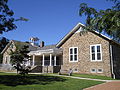
La Mott Camp Town | |
|---|---|
 Corner, Willow and Sycamore avenues, La Mott, Pennsylvania, 2012 | |
 La Mott Location of La Mott in Pennsylvania  La Mott La Mott (the United States) | |
| Coordinates: 40°04′04″N75°08′26″W / 40.06778°N 75.14056°W | |
| Country | United States |
| State | Pennsylvania |
| County | Montgomery |
| Township | Cheltenham |
| Commissioner | Harvey Portner |
| Area | |
• Total | .261 sq mi (0.68 km2) |
| • Land | .261 sq mi (0.68 km2) |
| • Water | 0.00 sq mi (0.0 km2) |
| Elevation | 230 ft (70 m) |
| Population (2010) | |
• Total | 3,554 |
| • Density | 14,000/sq mi (5,300/km2) |
| Time zone | UTC-5 (Eastern Standard Time) |
| • Summer (DST) | UTC-4 (Eastern Daylight Time) |
| Area codes | 215, 267 and 445 |
| Website | 66 |
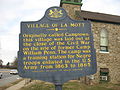
| Official name | Village of La Mott |
| Designated | June 1973 |
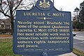
La Mott is an unincorporated community located within Cheltenham Township, Pennsylvania, United States. Its name honors the leading 19th Century abolitionist and suffragist, Lucretia Mott, who resided in the neighborhood.
Contents
Of the sixty-five locations in the continental United States named Mott, this is the only community named "La Mott." It borders Philadelphia, along Cheltenham Avenue, and has been assigned the ZIP code of 19027.