Franconia, Pennsylvania

Last updated
Franconia, Pennsylvania
Unincorporated community
Cambridge Reserve.jpg
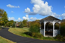
Cambridge Reserve in Franconia
USA Pennsylvania location map.svg
Red pog.svg
Franconia
Coordinates: 40°18′28″N75°21′28″W / 40.30778°N 75.35778°W / 40.30778; -75.35778 Coordinates: 40°18′28″N75°21′28″W / 40.30778°N 75.35778°W / 40.30778; -75.35778
Country United States
State Pennsylvania
County Montgomery
Township Franconia
Elevation
394 ft (120 m)
Time zone UTC-5 (Eastern (EST))
  Summer (DST) UTC-4 (EDT)
ZIP code
18924
Area code(s) 215, 267 and 445
GNIS feature ID1203621 [1]

Franconia is an unincorporated community in Franconia Township in Montgomery County, Pennsylvania, United States. Franconia is located at the intersection of Pennsylvania Route 113 and Allentown Road. [2]

Franconia opened its first Elementary School in December 1941. Franconia Elementary celebrated their 75th anniversary on October 6, 2016. Students of past and present were welcomed back to share the event with ever-growing community. At the 75th anniversary, the time capsule was opened, where many memories of the past students was shared and presented.

The village is named after Franconia, the English (and Latin) term for Franken, a region in Germany.

Notable people

Related Research Articles

Montgomery County, Pennsylvania County of Pennsylvania, United States

Montgomery County, locally also referred to as Montco, is the third most populous county in the U.S. state of the Commonwealth of Pennsylvania, and the 71st most populous in the United States. As of 2018, the census-estimated population of the county was 828,604, representing a 3.3% increase from the 799,884 residents enumerated in the 2010 census. Montgomery County is located adjacent to and northwest of Philadelphia. The county seat is Norristown. Montgomery County is geographically diverse, ranging from farms and open land in the extreme north of the county to densely populated suburban neighborhoods in the southern and central portions of the county.

Warrington Township, Bucks County, Pennsylvania Township in Pennsylvania, United States of America

Warrington Township is a township in Bucks County, Pennsylvania, United States. Warrington Township is a suburb of Philadelphia. The population was 23,418 at the 2010 census.

Abington Township, Montgomery County, Pennsylvania Township in Pennsylvania, United States

Abington Township is a township in Montgomery County, Pennsylvania, United States, adjacent to Philadelphia's northern fringe. The population was 55,310 as of the 2010 census, making it the second most populous township in Montgomery County. The population density is 3603.3 per square mile, making it the second most densely populated township in Montgomery County.

Collegeville, Pennsylvania Borough in Pennsylvania, United States

Collegeville is a borough in Montgomery County, Pennsylvania, a suburb of Philadelphia on the Perkiomen Creek. Collegeville was incorporated in 1896. It is the location of Ursinus College, opened in 1869. The population was 5,089 at the 2010 census.

Eagleville, Montgomery County, Pennsylvania Census-designated place in Pennsylvania, United States

Eagleville is a census-designated place (CDP) in Montgomery County, Pennsylvania, United States. The population was 4,800 at the 2010 census. It is within Lower Providence Township.

Harleysville, Pennsylvania Census-designated place in Pennsylvania, United States

Harleysville is a census-designated place (CDP) in Montgomery County, Pennsylvania, United States. It is a suburb of Philadelphia. The population was 9,286 at the 2010 census. It is located mostly within Lower Salford Township and also in Franconia Township. Harleysville was settled by Pennsylvania Dutch in the 18th century and was named after Samuel Harley.

Hatboro, Pennsylvania Borough in Pennsylvania, United States

Hatboro is a borough in Montgomery County, Pennsylvania, United States. The population was 7,360 at the 2010 census.

Horsham Township, Montgomery County, Pennsylvania Home Rule Municipality in Pennsylvania, United States

Horsham Township is a home rule municipality in Montgomery County, Pennsylvania, United States, 10 miles north of downtown Philadelphia. The township, incorporated in 1717, is one of the oldest original municipalities in Montgomery County. Although it retains the word "Township" in its official name, it has been governed by a Home Rule Charter since 1975 and is therefore not subject to the Pennsylvania Township Code. The population was 26,147 at the 2010 census.

Lower Providence Township, Montgomery County, Pennsylvania Township in Pennsylvania, United States

Lower Providence Township is a township in Montgomery County, Pennsylvania, United States, about 17 miles northwest of Philadelphia. The population was 25,436 at the 2010 census.

Lower Salford Township, Montgomery County, Pennsylvania Township in Pennsylvania, United States

Lower Salford is a township in Montgomery County, Pennsylvania located one mile west of the Lansdale exit of the Pennsylvania Turnpike. It is centered on the intersection of Route 63, and Route 113.

North Wales, Pennsylvania Borough in Pennsylvania, United States

North Wales is a borough in Montgomery County, Pennsylvania, United States. It is a suburb of Philadelphia, and is one of the three historic population centers that make up the North Penn Valley, which is centered around the borough of Lansdale. The population was 3,229 as of the 2010 census.

Souderton, Pennsylvania Borough in Pennsylvania, United States

Souderton is a borough in Montgomery County, Pennsylvania. The population was 6,618 at the 2010 census.

Upper Dublin Township, Montgomery County, Pennsylvania Township in Pennsylvania, United States

Upper Dublin Township is a township in Montgomery County, Pennsylvania, United States. The population was 25,569 at the 2010 census. Until the 1950s, Upper Dublin was mostly farmland and open space, but transitioned to a residential suburb during the postwar population boom. The population went from just over 6,000 residents in the 1950s to just under 20,000 by 1970. Today, Upper Dublin is mostly spread-out development housing, and has the fourth highest median income in Montgomery County.

Radnor Township, Delaware County, Pennsylvania Township with home rule in Pennsylvania, United States

Radnor Township is an upper-class township with home rule status in Delaware County, Pennsylvania, United States. It contains the unincorporated communities of Garrett Hill, Rosemont, St. Davids, Strafford, Villanova and Wayne as well as areas with Bryn Mawr postal addresses and Newtown Square. As of the 2010 census, the township population was 31,531. Radnor Township lies along the Main Line, a collection of upper-middle class and upper-class Philadelphia suburbs.

Pennsylvanias 6th congressional district

Pennsylvania's 6th Congressional District is a congressional district in the state of Pennsylvania. It includes the entirety of Chester County, the city of Reading and its southeastern suburbs in Berks County. The district is represented by Democrat Chrissy Houlahan. The Supreme Court of Pennsylvania redrew the district in February 2018 after ruling the previous map unconstitutional.

Dock Mennonite Academy

Dock Mennonite Academy, formerly known as Christopher Dock Mennonite High School and Penn View Christian School is a private school in Montgomery County that is affiliated with the Franconia Mennonite Conference and the Eastern District Conference of the Mennonite Church USA. The school was named after schoolmaster Christopher Dock of Skippack, Pennsylvania. Dock's mission is to inspire and equip each student to serve with a global perspective by integrating faith, academic excellence, and life-enriching opportunities in a Christ-centered community. The school has two campuses and serves students in early childhood to grade twelve.

Pennsylvanias 7th congressional district

Pennsylvania's 7th congressional district includes all of Lehigh County and Northampton County as well as parts of Monroe County. The district is represented by Democrat Susan Wild.

Roychester is an unincorporated community within Abington Township in Montgomery County, Pennsylvania, United States.

Aulne, Kansas Unincorporated community in Kansas, United States

Aulne is an unincorporated community in Marion County, Kansas, United States. The Aulne name was suggested by officials of the railroad when it was built through Aulne during the 19th century.

Earlington, Pennsylvania Unincorporated community in Pennsylvania, United States

Earlington is an unincorporated community in Franconia Township in Montgomery County, Pennsylvania, United States. Earlington is located at the intersection of Allentown Road and Morwood Road. The Pinball Parlour is located on Allentown Road in Earlington.

References

  1. "Franconia". Geographic Names Information System . United States Geological Survey.
  2. Montgomery County, Pennsylvania Highway Map (PDF) (Map). PennDOT. 2015. Retrieved January 12, 2016.
  3. Gerard C. Wertkin (2 August 2004). Encyclopedia of American Folk Art . Routledge. ISBN   978-1-135-95614-1.