Perkiomen Township, Pennsylvania

Last updated
Perkiomen Township
Pennypacker Mills 1 Montco PA.jpg
Pennypacker Mills, built 1720
Perkiomen Township Montgomery County.png
Location of Pennsylvania in the United States
Coordinates: 40°15′06″N75°27′29″W / 40.25167°N 75.45806°W / 40.25167; -75.45806
CountryUnited States
StatePennsylvania
County Montgomery
Area
[1]
  Total4.93 sq mi (12.78 km2)
  Land4.86 sq mi (12.57 km2)
  Water0.08 sq mi (0.20 km2)
Elevation
148 ft (45 m)
Population
 (2010)
  Total9,139
  Estimate 
(2016) [2]
9,245
  Density1,904.22/sq mi (735.20/km2)
Time zone UTC-5 (EST)
  Summer (DST) UTC-4 (EDT)
Area code 610
FIPS code 42-091-59392
Website http://www.perkiomentownship.org

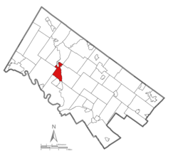
Perkiomen Township is a township in Montgomery County, Pennsylvania, United States. As of the 2010 census, the township population was 9,139, which represents a 28.8% increase from the 2000 total of 7,093 residents. Governmentally, it is a township of the second class, governed by a board of supervisors. It is part of the Perkiomen Valley School District. Perkiomen Township includes an abundance of history that goes as far back as to the first tribes who inhabited the area. This township started with the inhabitants of the Lenni-Lenape Tribe and progressed in many ways into what it is today.

Contents

History

First inhabitants

The Perkiomen Valley was first inhabited by the Lenni-Lenape Tribe and was declared part of the Commonwealth of Pennsylvania on March 4, 1681 by King Charles II of England. 
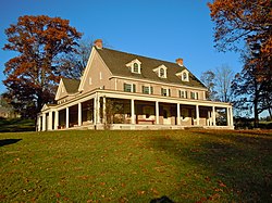
In 1720, the first copper mine in Pennsylvania was located near Schwenksville. The Perkiomen Valley provided the colonists and the Native Americans a rich place to grow crops and livestock, which would later feed the troops during the Revolutionary War. George Washington's troops rested in the Perkiomen Valley in a place called Valley Forge on their way to defeat the British and gain their autonomy over the thirteen colonies. One of the famous men that lived in the Perkiomen Valley was John James Audubon, a French-American ornithologist noted for his paintings and drawings of birds.

In 1784, Montgomery County was formed with land that was previously owned by the city of Philadelphia. Nearly a century later in 1879 Limerick Township was created and in 1886 the Skippack and Perkiomen Townships split into Skippack Township and Perkiomen Township. The Perkiomen Township later split into two different townships called Lower Perkiomen Township and Upper Perkiomen Township. Collegeville and Trappe are two towns in Montgomery County that were purchased by Ursinus College in 1869 and were later included in Upper Providence Township in 1896. In 1903, the Schwenksville Borough was incorporated into the Perkiomen Township.

In the 1990 federal census, nearly 59,000 people lived in the Perkiomen Valley. Limerick Township contains the Nuclear Power Plant that produces electricity for the Perkiomen Valley and is owned by a company called PECO. Many businesses that consider expanding to the suburbs of Philadelphia look towards the Perkiomen Valley as it is one of the major areas that are rapidly developing into a powerhouse of the suburbs of Philadelphia. They are also moving to the Perkiomen Valley because the businesses are able to escape many problems that having a business in Philadelphia creates and they are able to attract more skilled workers to their companies allowing them to grow. [3]

Early living styles

The Perkiomen Valley was once referred to as the “Goschenhoppen”, [4] named after the Northern American people who referred to themselves as Lenape. The vast majority of settlers were German. They were of Lutheran and German reformed faith. Their language was used exclusively and eventually evolved today into what is now known as Pennsylvania Dutch. Many old roads ran through Perkiomen valley and were maintained as well as roads are today. The people that lived on the roads did all of the upkeep. Farming was one of the settler's main ways of living until they discovered they could use their streams for operating mills. These mills were used for many different things such as gunpowder, mixing animal food, as well as cutting wood and graining flour. These mills provided the settlers with an easy way of production as well as a good source of income. The railroad was also a major transportation use. It went through many main places but ran along the Schuylkill River. Because of this major railroad, the cigar industry rose to success. This industry brought in an influx of workers, which resulted in a greater population. With more people came a more diverse civilization, as well as the construction of homes, stores, places of worship, and many more. This industry was appealing to both the artisan as well as the tradesmen, who took on the cigar business over farming. [4]

Perkiomen Watershed Conservacy (PWC)

The Perkiomen Watershed Conservancy at 362-square miles is a part of the Schuylkill River watershed. A watershed is a drainage basin that collects surface water from other running bodies of water. The Perkiomen Watershed plays a part in the Perkiomen Valley by creating a water system for this area. Originally called the Perkiomen Valley Watershed Association, it was started in 1964 to help address these poor water conditions in the Perkiomen Creek. When PWC first started it was divided between public education activities, continuing data collection, efforts to advance the idea of state water quality standards and a required degree of treatment for wastes discharged to streams. A half of century later in the first meetings, the PWC has helped clean trash from creeks, this has helped in the preserve the Spring Mountain area, this has helped educate children and adults. This program taught people about our connection to nature, how to preserve and repair riparian areas along local creeks to help reduce erosion and improve water quality.

Demographics

Historical population
CensusPop.Note
2000 7,093
2010 9,13928.8%
2020 8,959−2.0%
U.S. Decennial Census [5] [6]

As of the 2010 census, the township was 88.1% White, 4.1% Black or African American, 5.2% Asian, and 2.1% were two or more races. 2.9% of the population were of Hispanic or Latino ancestry [1].

As of the census of 2000, there were 7,093 people, 2,468 households, and 1,966 families residing in the township. The population density was 1,467.5 inhabitants per square mile (566.6/km2). There were 2,556 housing units at an average density of 528.8/sq mi (204.3/km2). The racial makeup of the township was 92.99% White, 3.14% African American, 0.11% Native American, 1.90% Asian, 0.07% Pacific Islander, 0.62% from other races, and 1.16% from two or more races. Hispanic or Latino of any race were 1.52% of the population.

There were 2,468 households, out of which 48.1% had children under the age of 18 living with them, 69.4% were married couples living together, 7.8% had a female householder with no husband present, and 20.3% were non-families. 16.2% of all households were made up of individuals, and 3.1% had someone living alone who was 65 years of age or older. The average household size was 2.87 and the average family size was 3.25.

In the township the population was spread out, with 31.7% under the age of 18, 4.4% from 18 to 24, 41.9% from 25 to 44, 16.7% from 45 to 64, and 5.3% who were 65 years of age or older. The median age was 33 years. For every 100 females there were 98.4 males. For every 100 females age 18 and over, there were 93.3 males.

The median income for a household in the township was $74,878, and the median income for a family was $82,046. Males had a median income of $52,358 versus $37,379 for females. The per capita income for the township was $27,800. About 3.0% of families and 3.6% of the population were below the poverty line, including 3.8% of those under age 18 and 2.1% of those age 65 or over.

Government and politics

Pennsylvania's current Governor is Josh Shapiro and the Secretary of the Commonwealth is Pedro Cortes. These two men represent all of Pennsylvania as well as Montgomery County. Montgomery County is governed by a three-person County Commission. The current composition is two Democrats and one Republican. By law, the County Commission must have one member of a minority party represented. The Commissioner of Montgomery County is Joseph C. Gale, Republican, and the Vice Chair is Valerie A. Arkoosh, MD, MPH, Democrat, and the Chair is Josh Shapiro, Democrat. [7] These three men and women are in charge of administering the county's government and are in charge of various departments. Some of the departments include County Administration, Judicial, Corrections, Health and General Welfare, Adult and Senior Services, Child Welfare, Law Enforcement and Public Safety and Veterans Affairs. [8]

Economy

Montgomery County has many companies that employ thousands of men and women. The company that employs the most men and women in Montgomery county is Merck which employs approximately 9,700 men and women. [9] Some of the other companies that employ many people include SEI Investment with 1,983 people, State Correctional Institution at Graterford with 1,300 employees, and Limerick Generating Station - Exelon Nuclear with 800 employees and Matheson Tri-Gas. [9] These are some of the major companies in the area but there are also small businesses that employ many of the men and women throughout Montgomery County. Some of the smaller but still significant employers include but are not limited to Springford Area School District with 1,020 employees, Perkiomen Valley School District with 761 employees, Pottstown School District with 550 employees, Owen J. Roberts School District with 642 employees, and Daniel Boone Area School District with 531 employees. A new shopping complex called Providence Town Center was built in 2009 and had many stores and restaurants built.

Transportation

PA 29 northbound in Perkiomen Township 2022-10-26 16 25 49 View north along Pennsylvania State Route 29 (Gravel Pike) just north of Pennsylvania State Route 113 (Bridge Road) in Perkiomen Township, Montgomery County, Pennsylvania.jpg
PA 29 northbound in Perkiomen Township

As of 2020 there were 36.11 miles (58.11 km) of public roads in Perkiomen Township, of which 8.05 miles (12.96 km) were maintained by the Pennsylvania Department of Transportation (PennDOT) and 28.06 miles (45.16 km) were maintained by the township. [10]

Pennsylvania Route 29, Pennsylvania Route 73 and Pennsylvania Route 113 are the primary highways serving Perkiomen Township. PA 29 follows the Gravel Pike along a north-south alignment through the township. PA 73 follows Skippack Pike on a brief east-west alignment near the north edge of the township. Finally, PA 113 follows Bridge Road along an east-west alignment near the south end of the township.

Education

Colleges and universities

Montgomery County Community College is a local community college that was founded in 1964 [11] and is located in Blue Bell. Their west campus is located in Pottstown and its culinary arts institution is located in Lansdale. [11]

Ursinus College is a private institution that was founded in 1869 [12] and is located in Collegeville. [12]

Primary and secondary schools

Perkiomen Township is a part of the Perkiomen Valley School District. [13]

Residents are zoned to three different elementary schools: Evergreen, Schwenksville, and South. [14] Middle School West and Middle School East serve sections of the township. [15] All residents are zoned to Perkiomen Valley High School.

Related Research Articles

<span class="mw-page-title-main">Montgomery County, Pennsylvania</span> County in Pennsylvania, United States

Montgomery County, colloquially referred to as Montco, is a county in the Commonwealth of Pennsylvania. It is the third-most populous county in Pennsylvania and the 73rd-most populous county in the United States. As of the 2020 census, the population of the county was 856,553, representing a 7.1% increase from the 799,884 residents counted in the 2010 census. Montgomery County is located adjacent to and northwest of Philadelphia. The county seat and largest city is Norristown. Montgomery County is geographically diverse, ranging from farms and open land in the extreme north of the county to densely populated suburban neighborhoods in the southern and central portions of the county.

<span class="mw-page-title-main">Hereford Township, Berks County, Pennsylvania</span> Township in Pennsylvania, United States

Hereford Township is a township in Berks County, Pennsylvania, United States. It is the easternmost municipality within Berks County. Its population was 2,969 at the 2020 census. It is in Upper Perkiomen School District.

<span class="mw-page-title-main">Upper Saucon Township, Pennsylvania</span> Township in Pennsylvania, United States

Upper Saucon Township is a township in Lehigh County, Pennsylvania. It is part of the Lehigh Valley metropolitan area, which had a population of 861,899 and was the 68th-most populous metropolitan area in the U.S. as of the 2020 census. The township had a population of 16,973 as of the 2020 census.

<span class="mw-page-title-main">Audubon, Pennsylvania</span> Census-designated place in Pennsylvania, United States

Audubon is a census-designated place (CDP) in Lower Providence Township, Montgomery County, Pennsylvania, United States. It was named for naturalist John James Audubon, who lived there as a young man. The population was 8,433 at the 2010 census.

<span class="mw-page-title-main">Collegeville, Pennsylvania</span> Borough in Pennsylvania, United States

Collegeville is a borough in Montgomery County, Pennsylvania, a suburb outside of Philadelphia on Perkiomen Creek. Collegeville was incorporated in 1896. It is the location of Ursinus College, which opened in 1869. The population was 5,089 at the 2010 census.

<span class="mw-page-title-main">Harleysville, Pennsylvania</span> Census-designated place in Pennsylvania, United States

Harleysville is a census-designated place (CDP) in Montgomery County, Pennsylvania, United States. It is a suburb of Philadelphia. The population was 9,286 at the 2010 census. It is located mostly within Lower Salford Township and also in Franconia Township. Harleysville was settled by Pennsylvania Dutch in the 18th century and was named after Samuel Harley.

<span class="mw-page-title-main">Lower Frederick Township, Pennsylvania</span> Township in Pennsylvania, United States

Lower Frederick Township is a township in Montgomery County, Pennsylvania, United States. The population was 4,840 at the 2010 census.

<span class="mw-page-title-main">Lower Providence Township, Pennsylvania</span> Township in Pennsylvania, United States

Lower Providence Township is a township in Montgomery County, Pennsylvania, United States. The township is located approximately 17 miles northwest of Philadelphia. The population was 25,625 at the 2020 census.

<span class="mw-page-title-main">Lower Salford Township, Pennsylvania</span> Township in Pennsylvania, United States

Lower Salford is a township in Montgomery County, Pennsylvania. It is located one mile west of the Lansdale exit of the Pennsylvania Turnpike. It is centered on the intersection of Route 63, and Route 113.

<span class="mw-page-title-main">Schwenksville, Pennsylvania</span> Borough in Pennsylvania, United States

Schwenksville is a borough in Montgomery County, Pennsylvania, United States. The population was 1,431 at the 2020 census. It is notable for being located near the site of the Philadelphia Folk Festival. The borough was founded in 1684, when the Lenni-Lenape Indians ceded to William Penn the land along the Perkiomen Creek; it was incorporated in 1903. The borough was named for George Schwenk, whose son, Jacob Schwenk, served in George Washington's army.

<span class="mw-page-title-main">Skippack, Pennsylvania</span> Census-designated place in Pennsylvania, United States

Skippack is a census-designated place (CDP) in Skippack Township, Montgomery County, Pennsylvania, United States. The population was 3,758 at the 2010 census.

<span class="mw-page-title-main">Skippack Township, Pennsylvania</span> Township in Pennsylvania, United States

Skippack Township is a township in Montgomery County, Pennsylvania, United States. The population was 14,408 in 2022 according to the Census Bureau. This represents a 5.1% increase from the 2010 Census.

<span class="mw-page-title-main">Upper Providence Township, Montgomery County, Pennsylvania</span> Township in Pennsylvania, United States

Upper Providence Township is a township in Montgomery County, Pennsylvania, United States. As of the 2010 census, the township population was 21,219.

<span class="mw-page-title-main">Upper Salford Township, Pennsylvania</span> Township in Pennsylvania, United States

Upper Salford Township is a township in Montgomery County, Pennsylvania, United States. The population was 3,299 at the 2010 census.

<span class="mw-page-title-main">Whitemarsh Township, Pennsylvania</span> Home rule municipality in Pennsylvania, United States

Whitemarsh Township is a Home rule municipality in Montgomery County, Pennsylvania. It retains its former classification of "Township" in its official name despite being a home rule municipality. The population was 17,349 at the 2010 census. Whitemarsh is adjacent to the neighborhood of Andorra in the Roxborough section of Philadelphia, and is bordered in Montgomery County by Springfield, Upper Dublin, Whitpain, and Plymouth townships, Conshohocken, and the Schuylkill River, which separates it from Lower Merion Township.

<span class="mw-page-title-main">Worcester Township, Pennsylvania</span> Township in Pennsylvania, United States

Worcester Township is a township in Montgomery County, Pennsylvania, United States. The population was 9,750 at the 2010 census. It is pronounced as 'WOR-ses-ter.'

Graterford is an unincorporated community in Perkiomen Township, Montgomery County, Pennsylvania, United States.

<span class="mw-page-title-main">Pennsylvania Route 73</span> State highway in Pennsylvania, US

Pennsylvania Route 73 (PA 73) is a 62.32-mile (100.29 km) long east–west state highway in southeastern Pennsylvania. It runs from PA 61 near Leesport southeast to the New Jersey state line on the Tacony–Palmyra Bridge over the Delaware River in Philadelphia, where the road continues south as New Jersey Route 73. The route passes through rural areas of Berks County, crossing U.S. Route 222 (US 222) in Maiden Creek before heading southeast through Oley and Boyertown. PA 73 continues into Montgomery County and intersects PA 100 in Gilbertsville and PA 29 in Schwenksville before it heads into the northwest suburbs of Philadelphia. The route passes through Skippack and intersects US 202 in Center Square, PA 309 in Springfield Township, and PA 611 near Jenkintown. PA 73 continues through Northeast Philadelphia on Cottman Avenue, crossing US 1 and US 13 before coming to an interchange with Interstate 95 (I-95) near the Tacony–Palmyra Bridge.

The Perkiomen Valley School District (PVSD) is a school district based in central Montgomery County, Pennsylvania (US). It serves the boroughs of Collegeville, Trappe, and Schwenksville, and the townships of Lower Frederick, Perkiomen, and Skippack, in Pennsylvania. The district headquarters are in Perkiomen Township.

<span class="mw-page-title-main">Pennsylvania House of Representatives, District 70</span> American legislative district

The 70th Pennsylvania House of Representatives District is located in southeast Pennsylvania and has been represented by Matthew Bradford since 2009.

References

  1. "2016 U.S. Gazetteer Files". United States Census Bureau. Retrieved Aug 14, 2017.
  2. "Population and Housing Unit Estimates" . Retrieved June 9, 2017.
  3. "Welcome to Fox Heath Homeowners Association". www.foxheath.com. Archived from the original on 2016-04-16. Retrieved 2016-04-04.
  4. 1 2 "Historic and Cultural Sites - Upper Perkiomen Valley Chamber of Commerce | East Greenville, PA". www.upvchamber.org. Retrieved 2016-04-04.
  5. "Census of Population and Housing". Census.gov. Retrieved June 4, 2016.
  6. "Census 2020".
  7. "Montgomery County, PA - Official Website | Official Website". www.montcopa.org. Retrieved 2016-03-27.
  8. "Departments | Montgomery County, PA - Official Website". www.montcopa.org. Retrieved 2016-03-27.
  9. 1 2 "Largest Employers TriCounty Area Chamber Of Commerce". www.tricountyareachamber.com. Archived from the original on 2016-04-15. Retrieved 2016-03-27.
  10. "Perkiomen Township map" (PDF). PennDOT. Retrieved March 10, 2023.
  11. 1 2 Valerio, Leslie. "MCCC :: - About Us". www.mc3.edu. Retrieved 2016-03-25.
  12. 1 2 "Basic Facts | About Ursinus | Ursinus College". www.ursinus.edu. Retrieved 2016-03-25.
  13. "Maps." Perkiomen Township, Pennsylvania. Retrieved on October 9, 2018.
  14. "Elementary school boundary maps. Perkiomen Valley School District. Retrieved on October 9, 2018.
  15. Middle school boundary maps. Perkiomen Valley School District. Retrieved on October 9, 2018.