Glenside | |
---|---|
Coordinates: 40°06′11″N75°09′08″W / 40.10306°N 75.15222°W | |
Country | United States |
State | Pennsylvania |
County | Montgomery |
Townships | Abington, Cheltenham |
Area | |
• Total | 1.27 sq mi (3.29 km2) |
• Land | 1.27 sq mi (3.29 km2) |
• Water | 0.00 sq mi (0.00 km2) |
Elevation | 262 ft (80 m) |
Population | |
• Total | 7,737 |
• Density | 6,087.33/sq mi (2,349.42/km2) |
Time zone | UTC-5 (Eastern Standard Time) |
• Summer (DST) | UTC-4 (Eastern Daylight Time) |
ZIP Code | 19038 |
Area code | 215 |
Commissioners | J. Andrew Sharkey Kathy A. Hampton (East) |
Glenside is a census-designated place (CDP) located in Cheltenham Township and Abington Township in Montgomery County, Pennsylvania, United States. It borders Northwest Philadelphia. The population was 7,737 at the 2020 census on a land area of 1.3 square miles.
Glenside is most notable for its entertainment, including Keswick Theatre, restaurants, recreational facilities, and parks. Glenside station is one of the busiest in the SEPTA system. Glenside is located approximately eleven miles from Center City Philadelphia.
A railroad station called Tacony Station was erected in 1855, named for Tacony Creek, which flows through the settlement. [3] [4] It was later called Abington Station. [3] Glenside Post Office opened in 1888, and the railroad station was renamed Glenside station. [3]
The Glenside Fire Company was established in 1900, and firefighting equipment was stored in a building until a firehouse was erected in 1907. [4]
Glenside had two public schools: Glenside students living in Abington Township attended The Weldon School, and students in Cheltenham Township attended Glenside School, built in 1908. [5] Glenside School was demolished in the 1960s. [5]
In the early 1900s, Glenside had a "thriving business district" along Easton Road. [5] A bank, Glenside Trust Company, opened in 1922. [3]
According to the U.S. Census Bureau, Glenside has a total area of 1.3 square miles (3.4 km2), all land. Glenside is split into two townships: Abington Township, and Cheltenham Township. Cheltenham Township is the location of the United States Post Office, Glenside Library, and Glenside Memorial Hall.
Glenside has a typical Northeast climate. The following is a chart of the average temperatures in Glenside. [6]
Climate data for Glenside, Pennsylvania | |||||||||||||
---|---|---|---|---|---|---|---|---|---|---|---|---|---|
Month | Jan | Feb | Mar | Apr | May | Jun | Jul | Aug | Sep | Oct | Nov | Dec | Year |
Record high °F | 73 | 73 | 88 | 95 | 96 | 102 | 102 | 102 | 98 | 88 | 82 | 76 | 102 |
Mean daily maximum °F | 37 | 42 | 50 | 62 | 72 | 81 | 85 | 84 | 77 | 65 | 54 | 43 | 62.6 |
Mean daily minimum °F | 19 | 24 | 32 | 41 | 51 | 62 | 67 | 65 | 56 | 43 | 34 | 26 | 43 |
Record low °F | −11 | −3 | −1 | 16 | 32 | 34 | 45 | 37 | 30 | 20 | 11 | −10 | −11 |
Average precipitation inches | 3.44 | 3.01 | 4.32 | 4.12 | 4.37 | 4.6 | 5.05 | 3.98 | 4.53 | 3.82 | 3.94 | 4.23 | 49.4 |
Record high °C | 23 | 23 | 31 | 35 | 36 | 39 | 39 | 39 | 37 | 31 | 28 | 24 | 39 |
Mean daily maximum °C | 3 | 6 | 10 | 17 | 22 | 27 | 29 | 29 | 25 | 18 | 12 | 6 | 17.0 |
Mean daily minimum °C | −7 | −4 | 0 | 5 | 11 | 17 | 19 | 18 | 13 | 6 | 1 | −3 | 6 |
Record low °C | −24 | −19 | −18 | −9 | 0 | 1 | 7 | 3 | −1 | −7 | −12 | −23 | −24 |
Average precipitation mm | 87 | 76 | 110 | 105 | 111 | 120 | 128 | 101 | 115 | 97 | 100 | 107 | 1,250 |
Source: The Weather Channel "Average Weather for Glenside, PA". The Weather Channel. Archived from the original on March 5, 2010. Retrieved September 30, 2011. |
Census | Pop. | Note | %± |
---|---|---|---|
1990 | 8,704 | — | |
2000 | 7,914 | −9.1% | |
2010 | 8,384 | 5.9% | |
2020 | 7,737 | −7.7% | |
[7] [2] |
As of the 2020 census, the CDP was 91.0% White, 5.3% Black or African American, 1.0% Asian, and 1.6% were two or more races.
As of the 2010 census, the CDP was 85.4% White, 7.2% Black or African American, 0.2% Native American, 2.8% Asian, 1.0% were Some Other Race, and 1.7% were two or more races. 2.9% of the population were of Hispanic or Latino ancestry. [8]
As of the census [9] of 2000, there were 7,914 people, 3,103 households, and 2,013 families residing in the CDP. The population density was 6,217.4 inhabitants per square mile (2,400.6/km2). There were 3,181 housing units at an average density of 2,499.1 per square mile (964.9/km2). The racial makeup of the CDP was 88.97% White, 6.66% African American, 0.10% Native American, 3.02% Asian, 0.03% Pacific Islander, 0.27% from other races, and 0.96% from two or more races. Hispanic or Latino of any race were 1.44% of the population.
There were 3,103 households, out of which 31.3% had children under the age of 18 living with them, 52.7% were married couples living together, 9.2% had a female householder with no husband present, and 35.1% were non-families. 28.8% of all households were made up of individuals, and 9.7% had someone living alone who was 65 years of age or older. The average household size was 2.54 and the average family size was 3.21.
In the CDP, the population was spread out, with 25.0% under the age of 18, 8.0% from 18 to 24, 30.8% from 25 to 44, 22.3% from 45 to 64, and 13.8% who were 65 years of age or older. The median age was 36 years. For every 100 females, there were 91.3 males. For every 100 females age 18 and over, there were 87.3 males.
The median income for a household in the CDP was $58,868, and the median income for a family was $74,025. Males had a median income of $48,378 versus $35,629 for females. The per capita income for the CDP was $26,393. About 1.6% of families and 3.4% of the population were below the poverty line, including 2.4% of those under age 18 and 3.6% of those age 65 or over.
Newgrounds, an entertainment website, is headquartered in Glenside.
The annual Independence Day parade held in Glenside was founded in 1904.[ citation needed ]
Cheltenham Township School District operates one school in Glenside, Glenside Elementary. [11] Abington School District operates one school in Glenside, Copper Beech Elementary. [12]
Saint Luke Catholic School in Glenside is a parochial school, part of St. Luke The Evangelist Roman Catholic Church, with approximately 315 students in 2019. [13]
Arcadia University is found in Glenside, as well as Westminster Theological Seminary, a Protestant theological seminary.
Glenside is served by two weekly newspapers: Times Chronicle and Glenside News, both papers a division of Montgomery News. [14]
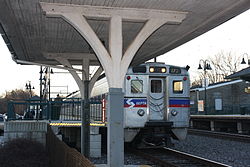
Glenside is served by SEPTA Regional Railroad at the Glenside station, originally known as Abington Station, whose roots date back to the North Pennsylvania Railroad and the Reading Railroad. Glenside is also served by SEPTA buses.
Montgomery County, colloquially referred to as Montco, is a county in the Commonwealth of Pennsylvania. As of the 2020 census, the population of the county was 856,553, making it the third-most populous county in Pennsylvania after Philadelphia and Allegheny counties. The county is part of the Southeast Pennsylvania region of the state.
Bryn Mawr is a census-designated place (CDP) located in Pennsylvania, United States. It is located just west of Philadelphia along Lancaster Avenue, also known as U.S. Route 30. As of 2020, the CDP is defined to include sections of Lower Merion Township, Montgomery County, as well as portions of Haverford Township and Radnor Township in Delaware County.
Paoli is a census-designated place (CDP) in Chester County near Philadelphia, Pennsylvania, United States. It is situated in portions of two townships: Tredyffrin and Willistown. At the 2020 census, it had a total population of 6,002.
Abington Township is a township in Montgomery County, Pennsylvania, United States. It is adjacent to Philadelphia's northern fringe. The population was 58,502 as of the 2020 census, making it the second most populous township in Montgomery County after Lower Merion Township. The population density is 3603.3 per square mile (1,377/km2), making it the second most densely populated township in Montgomery County after Cheltenham Township.
Fort Washington is a census-designated place and suburb of Philadelphia in Montgomery County, Pennsylvania, United States. The population was 5,446 at the 2010 census.
Jenkintown is a borough in Montgomery County, Pennsylvania. It is approximately 10 miles (16 km) north of Center City Philadelphia.
Oreland is a United States census-designated place (CDP) in Springfield and Upper Dublin townships, just outside the Chestnut Hill and Mount Airy areas of Philadelphia, Pennsylvania, United States. Oreland has a ZIP code of 19075, and the population was 5,678 at the 2010 census.
Plymouth Township is a township with home rule status in Montgomery County, Pennsylvania. The township has been governed by a home rule charter since 1976 and is no longer subject to the Pennsylvania Township Code. The population was 16,525 at the 2010 census. It is serviced by the Colonial School District and is home to the Plymouth Meeting Mall.
Rockledge is a borough in Montgomery County, Pennsylvania, United States. The population was 2,638 as of the 2020 census. Rockledge is surrounded by Abington Township and the city of Philadelphia, and shares a ZIP code with Jenkintown.
Springfield Township is a township in Montgomery County, Pennsylvania. The population was 20,993 in 2022 according the Census Bureau. It includes the villages of Wyndmoor, Erdenheim, Flourtown, and Oreland. The communities of Lafayette Hill, Fort Washington, Laverock, North Hills, Miquon, and Glenside are also situated partly inside the Township.
Upper Moreland Township is a township in Montgomery County, Pennsylvania. The population was 24,015 at the 2010 census. Upper Moreland Township is a primarily residential community located about 13 miles outside Center City Philadelphia. It is made up of distinctive neighborhoods that are complemented by several thriving business, industrial, and commercial districts.
Willow Grove is a census-designated place (CDP) in Montgomery County, Pennsylvania, United States. A community in Philadelphia's northern suburbs, the population was 13,730 at the 2020 census. It is located in Upper Dublin Township, Abington Township and Upper Moreland Township. Willow Grove was once known for Willow Grove Park, an amusement park that was open from 1896 to 1976, now the site of Willow Grove Park Mall. Willow Grove is considered an edge city of Philadelphia, with large amounts of retail and office space.
Wyncote is a census-designated place (CDP) in Cheltenham Township, Montgomery County, Pennsylvania, United States. It borders the northwestern and northeastern section of Philadelphia. Wyncote is located 11 miles from Center City Philadelphia at the southeasternmost tip of Montgomery County. The Jenkintown-Wyncote SEPTA station is the fifth busiest regional rail station in the SEPTA system.
Ardmore is an unincorporated community and census-designated place (CDP) spanning the border between Delaware and Montgomery counties in the U.S. state of Pennsylvania. The population was 12,455 at the time of the 2010 census and had risen to 13,566 in the 2020 census.
Elkins Park is an unincorporated community in Montgomery County, Pennsylvania, United States. It is split between Cheltenham and Abington Townships in the northern suburbs outside of Philadelphia, which it borders along Cheltenham Avenue roughly 7 miles (11 km) from Center City. The community is four station stops from Center City on Septa Regional Rail. It was listed as a census-designated place prior to the 2020 census.
Jenkintown–Wyncote station is a major SEPTA Regional Rail station along the SEPTA Main Line in Montgomery County, Pennsylvania. It is located at the intersection of Greenwood Avenue and West Avenue on the border of Jenkintown borough and the Wyncote neighborhood of Cheltenham Township, with a mailing address in Jenkintown. It is the ninth-busiest station in the regional rail system, and the fourth busiest outside Center City. Despite this, the station is not wheelchair accessible. SEPTA had plans to make the station wheelchair accessible by 2020, but these have not yet been completed.
Roslyn is an unincorporated community in Abington Township, Montgomery County, Pennsylvania, United States. Originally called Hillside, the name Roslyn came from rose gardens that once grew there.
Ardsley is an unincorporated community located in Abington Township, as well as Upper Dublin Township, Montgomery County, Pennsylvania, United States. It is a neighbor of Glenside. A large portion of this neighborhood is composed of the historic cemeteries Hillside Cemetery and Ardsley Burial Park. It is the location of the Ardsley SEPTA station.
Pennsylvania Route 152 (PA 152) is a 25.3-mile-long (40.7 km) state highway located in the U.S. state of Pennsylvania. The route travels north–south from an interchange with PA 309 located in the Cedarbrook neighborhood of Cheltenham Township in Montgomery County north to another interchange with PA 309 located northeast of Telford in Bucks County. PA 152 is known as Limekiln Pike for most of its length. From the southern terminus, the route passes through suburban areas to the north of Philadelphia, serving Dresher, Maple Glen, and Chalfont. North of Chalfont, PA 152 runs through rural suburbs of Philadelphia before reaching Silverdale. Past here, the road continues northwest through Perkasie, where it turns southwest and passes through Sellersville before reaching its northern terminus.
Cheltenham Township is a home rule municipality and Township of the First Class located in the southeast corner of Montgomery County, Pennsylvania, United States. It borders Philadelphia to the south and east, Abington Township and Jenkintown to the north, and Springfield Township to the west.