Melrose Park, Pennsylvania

Last updated
Melrose Park
Valley Rd, Melrose Park PA.JPG
Valley Road in Melrose Park, January 2013
USA Pennsylvania location map.svg
Red pog.svg
Melrose Park
Location of Melrose Park in Pennsylvania
Usa edcp location map.svg
Red pog.svg
Melrose Park
Melrose Park (the United States)
Coordinates: 40°03′42″N75°07′55″W / 40.06167°N 75.13194°W / 40.06167; -75.13194 Coordinates: 40°03′42″N75°07′55″W / 40.06167°N 75.13194°W / 40.06167; -75.13194
CountryUnited States
StatePennsylvania
CountyFlag of Montgomery County, Pennsylvania.png Montgomery
TownshipCheltenham PA township seal.svg Cheltenham
CommissionerDaniel B. Norris
Area
  Total.660 sq mi (1.71 km2)
Elevation
203 ft (62 m)
Population
 (2010)
  Total3,006
  Density4,600/sq mi (1,800/km2)
Time zone UTC-5 (EST)
  Summer (DST) UTC-4 (EDT)
Area codes 215, 267 and 445

Melrose Park is an unincorporated section of Cheltenham Township on the Philadelphia city line in Montgomery County, Pennsylvania, It is bordered to the south by Cheltenham Avenue, to the west by Old York Road, to the east by New Second Street and to the north by Ashbourne Road.

Contents

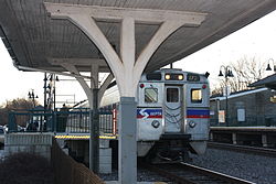
SEPTA provides public transportation to Melrose Park via the Melrose Park railroad station and SEPTA bus routes 28, 55, and 70.

Melrose Park is represented by Madeleine Dean in the 4th Congressional District. It is a close-in suburb outside of Philadelphia.

Gratz College

Melrose Park is home to Gratz College, the oldest independent institution of Jewish learning in the United States.

Notable people

Related Research Articles

<span class="mw-page-title-main">Jenkintown, Pennsylvania</span> Borough in Pennsylvania, United States

Jenkintown is a borough in Montgomery County, Pennsylvania, about 10 miles (16 km) north of Center City Philadelphia.

<span class="mw-page-title-main">Wyncote, Pennsylvania</span> Place in Pennsylvania, United States

Wyncote is a census-designated place (CDP) in Cheltenham Township, Montgomery County, Pennsylvania, United States. It borders the northwestern and northeastern section of Philadelphia. Wyncote is located 11 miles from Center City Philadelphia at the southeasternmost tip of Montgomery County. The Jenkintown-Wyncote SEPTA station is the fifth busiest regional rail station in the SEPTA system.

<span class="mw-page-title-main">Merion Station, Pennsylvania</span> Unincorporated community in Pennsylvania, United States

Merion Station is an unincorporated community in Pennsylvania, United States, bordering Philadelphia to the city's west. It is one of the communities that make up the Philadelphia Main Line, and is part of the municipality of Lower Merion Township, Montgomery County. Merion Station is known for its grand mansions and for the wealth of its residents.

Roosevelt Boulevard, officially named the Theodore Roosevelt Memorial Boulevard and often referred to, chiefly by local Philadelphians, simply as "the Boulevard," or "theBoully" is a major traffic artery through North and Northeast Philadelphia. The road begins at the Schuylkill Expressway in Fairmount Park, running as a freeway also known as the Roosevelt Boulevard Extension or the Roosevelt Expressway through North Philadelphia, then transitioning into a twelve-lane divided highway that forms the spine of Northeast Philadelphia to its end at the city line.

<span class="mw-page-title-main">Elkins Park, Pennsylvania</span> Unincorporated community in Montgomery County, Pennsylvania, United States

Elkins Park is an unincorporated community in Montgomery County, Pennsylvania. It is split between Cheltenham and Abington Townships in the northern suburbs outside of Philadelphia, which it borders along Cheltenham Avenue roughly 7 miles (11 km) from Center City. It is four station stops from Center City on Septa Regional Rail. It was listed as a census-designated place prior to the 2020 census.

<span class="mw-page-title-main">Fern Rock, Philadelphia</span> Neighborhood of Philadelphia in Philadelphia County, Pennsylvania, United States

Fern Rock is a neighborhood in the upper North Philadelphia section of Philadelphia, Pennsylvania bounded by Olney to the east, Ogontz to the west, Logan to the south, and East Oak Lane to the north. It is approximately situated between Broad Street, Tabor Road, 7th Street, Godfrey Avenue and Fisher Park. Fern Rock borders Ogontz at Broad Street, Logan at Olney Avenue, East Oak Lane at Godfrey Avenue, and Olney at the train tracks.

<span class="mw-page-title-main">Melrose Park station (SEPTA)</span>

Melrose Park station is a SEPTA Regional Rail station in Melrose Park, Pennsylvania. Located at the intersection of Valley Road and Mill Road, it serves the Lansdale/Doylestown, Warminster, and West Trenton lines.

<span class="mw-page-title-main">West Oak Lane, Philadelphia</span> Neighborhood of Philadelphia in Philadelphia County, Pennsylvania, United States

West Oak Lane is a neighborhood in the Northwestern Philadelphia. The neighborhood was developed primarily between the early 1920s and late 1930s, with the areas near to Cedarbrook constructed after World War II. At the northeast corner of Limekiln Pike and Washington Lane was the site of the Cedar Park Inn, a historic tavern built in the early 19th century, which was torn down sometime after 1931 as the neighborhood was being fully developed.

<span class="mw-page-title-main">Elkins Park station</span>

Elkins Park station is a SEPTA Regional Rail station located in the Elkins Park neighborhood of Cheltenham Township in Montgomery County, Pennsylvania. The station building is listed on the National Register of Historic Places for its notable architecture. The station is located at the intersection of Park Avenue and Spring Avenue. Elkins Park station is served by the Warminster Line, West Trenton Line, and Lansdale/Doylestown Line.

<span class="mw-page-title-main">Cheltenham station (SEPTA)</span>

Cheltenham station is a SEPTA Regional Rail station in Cheltenham, Pennsylvania. Located at Old Soldiers Road and Hasbrook Avenue, it serves the Fox Chase Line. The station has a 17-space parking lot. In FY 2013, Cheltenham station had a weekday average of 267 boardings and 392 alightings.

<span class="mw-page-title-main">Broad Street (Philadelphia)</span> Thoroughfare in Pennsylvania

Broad Street is a major arterial street in Philadelphia, Pennsylvania, USA. The street runs for approximately 13 miles (21 km), beginning at the intersection of Cheltenham Avenue on the border of Cheltenham Township and the West/East Oak Lane neighborhoods of North Philadelphia to the Philadelphia Navy Yard in South Philadelphia. It is Pennsylvania Route 611 along its entire length with the exception of its northernmost part between Old York Road and Pennsylvania Route 309 and the southernmost part south of Interstate 95.

<span class="mw-page-title-main">Logan, Philadelphia</span> Neighborhood of Philadelphia in Philadelphia County, Pennsylvania, United States

Logan is a neighborhood in the upper North Philadelphia section of the city of Philadelphia, in the U.S. state of Pennsylvania. The majority of the neighborhood falls within the 19141 zip code, but some of it falls within 19140. The neighborhood is sometimes confused with the Olney neighborhood of Philadelphia. Olney Avenue extends from both the Olney and Logan neighborhoods of the city. The Olney Transportation Center is located in Logan.

<span class="mw-page-title-main">Gratz College</span> Private Jewish college in Melrose Park, Pennsylvania, United States

Gratz College is a private Jewish college in Melrose Park, Pennsylvania. The college traces its origins to 1856 when banker, philanthropist, and communal leader Hyman Gratz and the Hebrew Education Society of Philadelphia joined to establish a trust to create a Hebrew teachers college. Gratz is a private liberal arts college located in a suburban setting and is primarily a commuter campus with online courses.

<span class="mw-page-title-main">Pennsylvania Route 232</span> State highway in Pennsylvania, US

Pennsylvania Route 232 (PA 232) is a 25.2-mile-long (40.6 km) state highway located in southeastern Pennsylvania. The southern terminus of the route is at U.S. Route 1 (US 1)/US 13 at the Oxford Circle in Philadelphia. The northern terminus is at PA 32 in the borough of New Hope, Bucks County, on the banks of the Delaware River. The route passes through the urban areas of Northeast Philadelphia as Oxford Avenue, serving the Lawncrest, Burholme, and Fox Chase neighborhoods. Upon entering Montgomery County, PA 232 becomes Huntingdon Pike and through suburban areas, serving the communities of Rockledge, Huntingdon Valley, and Bryn Athyn. The route passes through more suburban development in Bucks County as Second Street Pike, running through Southampton and Richboro. In Wrightstown Township, PA 232 enters rural areas and becomes Windy Bush Road as it heads north to New Hope.

<span class="mw-page-title-main">SEPTA City Transit Division surface routes</span> Wikimedia list article

The City Transit Division of the Southeastern Pennsylvania Transportation Authority (SEPTA) operates almost all of Philadelphia's public transit, including all 6 trolley, 3 trackless trolley and 70 bus lines within city limits. Some of the bordering municipalities are served by the City Transit division, despite not being part of the city. For example, Cheltenham Township has 13 city division routes and no Suburban Division ones. The City Transit division also operates the 400 Series routes which are designed to serve students attending schools in the city of Philadelphia.

<span class="mw-page-title-main">Pennsylvania Route 152</span> State highway in Pennsylvania, US

Pennsylvania Route 152 (PA 152) is a 25.3-mile-long (40.7 km) state highway located in the U.S. state of Pennsylvania. The route travels north–south from an interchange with PA 309 located in the Cedarbrook neighborhood of Cheltenham Township in Montgomery County north to another interchange with PA 309 located northeast of Telford in Bucks County. PA 152 is known as Limekiln Pike for most of its length. From the southern terminus, the route passes through suburban areas to the north of Philadelphia, serving Dresher, Maple Glen, and Chalfont. North of Chalfont, PA 152 runs through rural suburbs of Philadelphia before reaching Silverdale. Past here, the road continues northwest through Perkasie, where it turns southwest and passes through Sellersville before reaching its northern terminus.

<span class="mw-page-title-main">U.S. Route 13 in Pennsylvania</span> Highway in Pennsylvania

U.S. Route 13 is a U.S. highway running from Fayetteville, North Carolina, north to Morrisville, Pennsylvania. The route runs for 49.36 mi (79.44 km) through the Philadelphia metropolitan area in the U.S. state of Pennsylvania. The route enters the state from Delaware in Marcus Hook, Delaware County. It continues northeast through Delaware County, passing through the city of Chester before heading through suburban areas along Chester Pike to Darby. US 13 enters the city of Philadelphia on Baltimore Avenue and runs through West Philadelphia to University City, where it turns north along several city streets before heading east across the Schuylkill River along Girard Avenue. The route turns north and heads to North Philadelphia, where it runs northeast along Hunting Park Avenue. US 13 becomes concurrent with US 1 on Roosevelt Boulevard, continuing into Northeast Philadelphia. US 13 splits southeast on a one-way pair of streets before heading northeast out of the city on Frankford Avenue. The route continues into Bucks County as Bristol Pike, heading northeast to Bristol, where it turns into a divided highway. US 13 becomes a freeway in Tullytown and continues north to its terminus at US 1 in Falls Township, near Morrisville. US 13 roughly parallels Interstate 95 (I-95) through its course in Pennsylvania.

<span class="mw-page-title-main">SEPTA Route 6</span>

SEPTA's Trolley Route 6, also known as the Ogontz Avenue Line is a former streetcar line and current bus route, operated by the Southeastern Pennsylvania Transportation Authority (SEPTA) in Philadelphia, Pennsylvania, United States.

Cheltenham Avenue is a major east-west road in Southeastern Pennsylvania. It is served by many SEPTA bus routes, trolleys, regional rail, and subway. Cheltenham Avenue is designated an unsigned quadrant route numbered State Route 2035 in its western section. It also is a major borderline; it defines the border between Springfield and Cheltenham townships, and Cheltenham Township and the City of Philadelphia, with the latter also being the Montgomery County and Philadelphia County. A section of the road along the Philadelphia–Cheltenham border is part of Pennsylvania Route 309.

<span class="mw-page-title-main">Cheltenham Township, Montgomery County, Pennsylvania</span> Place in Pennsylvania, United States

Cheltenham Township is a home rule township in Montgomery County, Pennsylvania. Cheltenham's population density ranges from over 10,000 per square mile in rowhouses and high-rise apartments along Cheltenham Avenue to historic neighborhoods in Wyncote and Elkins Park. It is the most densely populated township in Montgomery County. The population was 36,793 at the 2010 U.S. Census, making it the third most populous township in Montgomery County and the 27th most populous municipality in Pennsylvania. It was originally part of Philadelphia County, and it became part of Montgomery County upon that county's creation in 1784.