Milford Township is a township in Bucks County, Pennsylvania, United States. The population was 9,902 at the 2010 census. It is home to the Quakertown interchange of the Pennsylvania Turnpike Northeast Extension, also known as Interstate 476.

Upper Hanover Township is a township in Montgomery County, Pennsylvania, United States. The population was 6,464 at the 2010 census.
Shimerville is an unincorporated community, located on Pennsylvania Route 100 and Pennsylvania Route 29 South in Upper Milford Township in Lehigh County, Pennsylvania. The community is located outside and to the south of Macungie and to the west of Vera Cruz. It is part of the Lehigh Valley, which has a population of 861,899 and is the 68th-most populous metropolitan area in the U.S. as of the 2020 census.

Pennsylvania Route 663 (PA 663) is a 22.13-mile-long (35.61 km) state highway in Montgomery and Bucks counties in southeast Pennsylvania. Its southern terminus is at PA 100 in the borough of Pottstown and its northern terminus is at PA 309 and PA 313 in the borough of Quakertown, where the road continues eastward as PA 313. Along the way, PA 663 also passes through the borough of Pennsburg. It is called John Fries Highway between Pennsburg and Quakertown. It has an interchange with Interstate 476 at exit 44 west of Quakertown. The route was assigned in 1930, and it has had several realignments since its commissioning, including two major ones.
Zieglerville is an unincorporated community in Lower Frederick Township in Montgomery County, Pennsylvania, United States. Its ZIP Code is 19492 and it is located on the west side of the Perkiomen Creek where PA Route 29 and PA Route 73 split at a roundabout, just north of Schwenksville.
The 131st Pennsylvania House of Representatives District is located in Southeastern Pennsylvania and has been represented since 2020 by Milou Mackenzie
Limeport is a small unincorporated community on the Saucon Creek in Lower Milford Township and Upper Saucon Township in Lehigh County, Pennsylvania. It is part of the Lehigh Valley, which has a population of 861,899 and is the 68th-most populous metropolitan area in the U.S., as of the 2020 census.
Eckville is an unincorporated community in far northern Berks County, Pennsylvania, United States. The town is located in an agricultural zone at the base of Blue Mountain, in northwestern Albany Township. Eckville is served by the Kutztown Area School District, and is approximately 17 miles (27 km) from the high school. It is near the head of the Pine Creek, which flows east-southeastward to the Maiden Creek.

Seisholtzville is a village that is primarily located in Hereford Township, Pennsylvania, with a portion of the village located in Longswamp Township.

Chapel is a village located on Pennsylvania Route 29 and the Perkiomen Creek in Hereford Township, Berks County and Upper Hanover Township, Montgomery County in the U.S. state of Pennsylvania. It uses the 18070 zip code of Palm, which is located just to the southeast. It is served by the Upper Perkiomen School District and uses the area code of 215.
Hosensack (HOE-zen-sak) is an unincorporated community in Lower Milford Township in Lehigh County, Pennsylvania. It is part of the Lehigh Valley region of eastern Pennsylvania, which has a population of 861,899 and was the 68th-most populous metropolitan area in the U.S. as of the 2020 census.
Finland is a village and an unincorporated community on the Unami Creek in southern Milford Township, Bucks County, Pennsylvania, United States. It is split between the Green Lane Zip Code of 18054 and the Pennsburg zip code of 18073. The immediate area was known in the 1920s as the "Poconos of Philadelphia" and as "The Fineland," and it is from this latter name that the US post office had put it on the map as Finland in 1886. Multiple summer camps have been located in this area and one of them is still in use. The Unami Creek flows southward to the Perkiomen Creek. The village was established by Finnish immigrants to New Sweden.
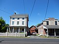
Spinnerstown is a census-designated place in Milford Township, Bucks County, Pennsylvania, United States. It is located just northwest of the Quakertown interchange of I-476 with Route 663. As of the 2010 census, the population was 1,826 residents.

Five Points is a village in Hereford Township, Berks County, Pennsylvania, United States, located on the Perkiomen Creek near the boundary with Lehigh County. It is named for the intersection of Deer Hill, Five Points, Sigmund, Township, and Weaver Roads. The village of Hereford is located less than two miles to the southeast. It is split between the ZIP codes of Barto 19504, Macungie 18062, and Zionsville 18092.

Gauff Hill is an unincorporated community in the extreme eastern Salisbury Township in Lehigh County, Pennsylvania. It is part of the Lehigh Valley, which has a population of 861,899 and was the 68th-most populous metropolitan area in the U.S. as of the 2020 census.
Layfield is an unincorporated community in northwestern Montgomery County, Pennsylvania, on Route 73 and Route 663. It is located in New Hanover Township on the Swamp Creek, a tributary of the Perkiomen Creek. For a fraction of a mile 663 follows 73 in Layfield. 663 coming from Pennsburg is Layfield Road and coming from Pottstown is North Charlotte Street. Layfield is split between the Gilbertsville and Perkiomenville post offices, which use the zip codes of 19525 and 18074, respectively.
Unionville is a suburban community in the Delaware Valley located on Pennsylvania Route 309. It is mainly in Hatfield Township, Montgomery County but also in Hilltown Township, Bucks County, Pennsylvania, United States.

Sumneytown is an unincorporated community that is situated on Route 63 in Marlborough Township, Montgomery County, Pennsylvania, United States.
Amity is an unincorporated community located in Springfield Township, Bucks County, Pennsylvania, United States.
Corning is a village in far southern Lehigh County, Pennsylvania, located in both Upper Milford and Lower Milford Townships. It borders Berks and Montgomery Counties.