Ivyland, Pennsylvania

Last updated
Ivyland, Pennsylvania
Ivyland HD Gough Ave 79.JPG
Ivyland Seal Digital.png
Bucks County Pennsylvania Incorporated and Unincorporated areas Ivyland Highlighted.svg
Location of Ivyland in Bucks County, Pennsylvania.
USA Pennsylvania location map.svg
Red pog.svg
Ivyland
Location of Ivyland in Pennsylvania
Usa edcp location map.svg
Red pog.svg
Ivyland
Ivyland (the United States)
Coordinates: 40°12′32″N75°04′19″W / 40.20889°N 75.07194°W / 40.20889; -75.07194
CountryUnited States
State Pennsylvania
County Bucks
Government
  MayorTony Judice
Area
[1]
  Total0.35 sq mi (0.92 km2)
  Land0.35 sq mi (0.92 km2)
  Water0.00 sq mi (0.00 km2)
Elevation
299 ft (91 m)
Population
 (2020) [2]
  Total955
  Density2,690.14/sq mi (1,039.98/km2)
Time zone UTC-5 (Eastern (EST))
  Summer (DST) UTC-4 (EDT)
ZIP Code
18974
Area codes 215, 267 and 445
FIPS code 42-37304
Website www.ivylandborough.org

Ivyland is a borough in Bucks County, Pennsylvania. It is known for one of the finest collections of Victorian buildings in the state, most of which are registered with the National Register of Historic Places. The population was 1,041 at the 2010 census, a 111.6% increase from the 2000 census.

Contents

Geography

Ivyland is located at 40°12′32″N75°4′19″W / 40.20889°N 75.07194°W / 40.20889; -75.07194 (40.208908, -75.071946). [3] According to the U.S. Census Bureau, the borough has a total area of 0.3 square miles (0.78 km2), all land, making it the smallest borough in Bucks County.

The east end of Ivyland was once a separate village named Bradyville. [4]

History

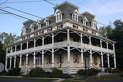
Ivyland was founded in 1873 by Edwin Lacey, a Quaker who was related to John Lacey, a brigadier general in the American Revolution. Edwin Lacey purchased 40 acres (16 ha) of land between Jacksonville Road (today's PA 332) and the Reading Company's future New Hope rail line, today's New Hope Railroad, which was completed to New Hope in 1891. It, as well as a large hotel which was planned for the town, was intended to serve the centennial of the signing of the Declaration of Independence.

According to the borough's website, Edwin Lacey, who apparently was no botanist, named the town for the vast amount of "ivy" growing in the area, which turned out to be poison ivy. [5]

The railroad line from the county line to Bristol Road opened November 9, 1874. Samuel Davis quarried the stone for the bed and for a bridge over a local stream, supplied horses and carts for the grading, and boarded the construction workers. In return, he took payment as stocks and bonds, and was also offered a lifetime pass on the railroad. He is reported to have stated "I never knew dividends to be paid out of passes. I have asked friends to put their money in this railroad, promising them interest on their investment, and I can't let them down. Furthermore, if I cannot afford to pay my way on the train, I had better stay home." [4]

The first post office was opened October 26, 1889, Wilmer Carr, postmaster. [4]

Ivyland was incorporated as a borough in 1903.

Passenger rail service was cut off in 1952 by the Reading, which later sold that portion of the rail line to the New Hope and Ivyland Railroad in 1966.

The Ivyland Historic District was added to the National Register of Historic Places in 2002. [6]

Demographics

Historical population
CensusPop.Note
1880 173
1910 247
1920 2636.5%
1930 30716.7%
1940 3183.6%
1950 35812.6%
1960 42518.7%
1970 60041.2%
1980 66110.2%
1990 490−25.9%
2000 4920.4%
2010 1,041111.6%
2020 955−8.3%
Sources: [7] [8] [9] [10] [2]

As of the 2010 census, the borough was 88.3% White, 0.4% Black or African American, 7.8% Asian, and 2.0% were two or more races. 2.4% of the population were of Hispanic or Latino ancestry .

As of the census [8] of 2000, there were 492 people, 194 households, and 152 families residing in the borough. The population density was 1,600.3 inhabitants per square mile (617.9/km2). There were 199 housing units at an average density of 647.3 per square mile (249.9/km2). The racial makeup of the borough was 95.53% White, 1.02% Native American, 2.85% Asian, 0.20% from other races, and 0.41% from two or more races. Hispanic or Latino of any race were 1.83% of the population.

There were 194 households, out of which 32.0% had children under the age of 18 living with them, 62.9% were married couples living together, 13.4% had a female householder with no husband present, and 21.6% were non-families. 19.1% of all households were made up of individuals, and 7.7% had someone living alone who was 65 years of age or older. The average household size was 2.52 and the average family size was 2.83.

In the borough, the population was spread out, with 21.1% under the age of 18, 6.9% from 18 to 24, 31.1% from 25 to 44, 26.0% from 45 to 64, and 14.8% who were 65 years of age or older. The median age was 39 years. For every 100 females, there were 90.7 males. For every 100 females age 18 and over, there were 86.5 males.

The median income for a household in the borough was $58,958, and the median income for a family was $63,750. Males had a median income of $43,750 versus $36,136 for females. The per capita income for the borough was $26,525. About 2.1% of families and 3.6% of the population were below the poverty line, including 4.0% of those under age 18 and 5.0% of those age 65 or over.

"Old" Ivyland vs "New" Ivyland

Ivyland Borough recently acquired a newly built community. The new community, Ivyland Village, was developed by Judd Builders and added a multitude of single family homes, as well as townhouses. Judd had strict requirements in building in order not to detract from the "Old" Ivyland style.

"New" Ivyland Borders

Ivyland Village is on the east side of State Route 332 (Jacksonville Road) and is bordered by Johnsville Boulevard, Kirk Road, and the Ann's Choice retirement community. [11]

Climate

According to the Köppen climate classification system, Ivyland has a Hot-summer, Humid continental climate (Dfa). Dfa climates are characterized by at least one month having an average mean temperature ≤ 32.0 °F (0.0 °C), at least four months with an average mean temperature ≥ 50.0 °F (10.0 °C), at least one month with an average mean temperature ≥ 71.6 °F (22.0 °C) and no significant precipitation difference between seasons. Although most summer days are slightly humid in Ivyland, episodes of heat and high humidity can occur with heat index values > 107 °F (42 °C). Since 1981, the highest air temperature was 102.5 °F (39.2 °C) on July 22, 2011, and the highest daily average mean dew point was 75.2 °F (24.0 °C) on August 12, 2016. The average wettest month is July, which corresponds with the annual peak in thunderstorm activity. Since 1981, the wettest calendar day was 6.80 inches (173 mm) on September 16, 1999. During the winter months, the average annual extreme minimum air temperature is 1.1 °F (−17.2 °C). [12] Since 1981, the coldest air temperature was −10.3 °F (−23.5 °C) on January 22, 1984. Episodes of extreme cold and wind can occur, with wind chill values < −9 °F (−23 °C). The average annual snowfall (Nov-Apr) is between 24 inches (61 cm) and 30 inches (76 cm). Ice storms and large snowstorms depositing ≥ 12 inches (30 cm) of snow occur once every few years, particularly during nor’easters from December through February.

Climate data for Ivyland, Elevation 282 ft (86 m), 1981-2010 normals, extremes 1981-2018
MonthJanFebMarAprMayJunJulAugSepOctNovDecYear
Record high °F (°C)71.0
(21.7)
77.5
(25.3)
86.8
(30.4)
93.6
(34.2)
94.7
(34.8)
95.7
(35.4)
102.5
(39.2)
100.0
(37.8)
97.6
(36.4)
88.8
(31.6)
80.8
(27.1)
75.3
(24.1)
102.5
(39.2)
Average high °F (°C)39.5
(4.2)
42.7
(5.9)
50.9
(10.5)
62.6
(17.0)
72.4
(22.4)
81.5
(27.5)
85.6
(29.8)
84.1
(28.9)
77.1
(25.1)
65.9
(18.8)
55.0
(12.8)
43.7
(6.5)
63.5
(17.5)
Daily mean °F (°C)31.2
(−0.4)
33.9
(1.1)
41.4
(5.2)
52.1
(11.2)
61.7
(16.5)
71.1
(21.7)
75.6
(24.2)
74.2
(23.4)
66.9
(19.4)
55.2
(12.9)
45.6
(7.6)
35.7
(2.1)
53.8
(12.1)
Average low °F (°C)23.0
(−5.0)
25.2
(−3.8)
32.0
(0.0)
41.5
(5.3)
50.9
(10.5)
60.7
(15.9)
65.5
(18.6)
64.2
(17.9)
56.6
(13.7)
44.5
(6.9)
36.1
(2.3)
27.6
(−2.4)
44.1
(6.7)
Record low °F (°C)−10.3
(−23.5)
−2.7
(−19.3)
3.6
(−15.8)
17.6
(−8.0)
34.3
(1.3)
42.2
(5.7)
48.8
(9.3)
43.2
(6.2)
36.2
(2.3)
24.6
(−4.1)
12.2
(−11.0)
−1.5
(−18.6)
−10.3
(−23.5)
Average precipitation inches (mm)3.44
(87)
2.70
(69)
3.97
(101)
4.00
(102)
4.32
(110)
4.26
(108)
5.18
(132)
4.34
(110)
4.39
(112)
3.76
(96)
3.69
(94)
3.96
(101)
48.01
(1,219)
Average relative humidity (%)66.462.958.957.862.166.367.369.370.569.867.968.465.7
Average dew point °F (°C)21.3
(−5.9)
22.6
(−5.2)
28.1
(−2.2)
37.7
(3.2)
48.6
(9.2)
59.3
(15.2)
64.0
(17.8)
63.5
(17.5)
57.0
(13.9)
45.5
(7.5)
35.6
(2.0)
26.3
(−3.2)
42.6
(5.9)
Source: PRISM [13]

Transportation

PA 332 westbound along the edge of Ivyland 2022-09-20 12 40 51 View west along Pennsylvania State Route 332 (Jacksonville Road) just west of Bristol Road along the border of Ivyland and Warminster Township in Bucks County, Pennsylvania.jpg
PA 332 westbound along the edge of Ivyland

As of 2007, there were 5.06 miles (8.14 km) of public roads in Ivyland, of which 1.19 miles (1.92 km) were maintained by the Pennsylvania Department of Transportation (PennDOT) and 3.87 miles (6.23 km) were maintained by the borough. [14]

Pennsylvania Route 332 is the only numbered highway serving Ivyland. It follows Jacksonville Road along a northeast-southwest alignment on the southeastern side of the borough.

Ecology

According to the A. W. Kuchler U.S. potential natural vegetation types, Ivyland would have a dominant vegetation type of Appalachian Oak (104) with a dominant vegetation form of Eastern Hardwood Forest (25). [15] The plant hardiness zone is 7a with an average annual extreme minimum air temperature of 1.1 °F (−17.2 °C). [12] The spring bloom typically begins by April 9 and fall color usually peaks by November 1.

Related Research Articles

<span class="mw-page-title-main">Bristol Township, Bucks County, Pennsylvania</span> Township in Pennsylvania, United States

Bristol Township is a township in Bucks County, Pennsylvania, United States. The population was 54,582 at the 2010 census, making it the 13th largest municipality in the state. Bristol Township, along with Bristol Borough, is a cultural hub for Lower Bucks County, hosting celebrations of African and Latino heritage. Parts of the township consist of the neighborhoods of Fairless Hills and Levittown. It is located within the Delaware Valley.

<span class="mw-page-title-main">Dublin, Pennsylvania</span> Borough in Pennsylvania, United States

Dublin is a borough in Bucks County, Pennsylvania. The population was 2,158 at the 2010 census. Dublin is part of Pennridge School District.

<span class="mw-page-title-main">Falls Township, Bucks County, Pennsylvania</span> Township in Pennsylvania, United States

Falls Township is a suburban Philadelphia township in Bucks County, Pennsylvania. The population was 34,300 at the 2010 census. Portions of Fairless Hills and Levittown, Pennsylvania, are located in the township. Portions of Falls Township are called Morrisville and Yardley, due to the location of the Morrisville Post Office outside the Borough of Morrisville in Falls Township. As originally chartered in 1692, the villages of Morrisville and Tullytown were part of Falls Township. Morrisville was granted borough status in 1804. Tullytown was erected as a borough in 1891.

<span class="mw-page-title-main">Haycock Township, Bucks County, Pennsylvania</span> Township in Pennsylvania, United States

Haycock Township is a township in Bucks County, Pennsylvania, United States. The population was 2,225 at the 2010 census.

<span class="mw-page-title-main">Hulmeville, Pennsylvania</span> Borough in Pennsylvania, United States

Hulmeville is a borough in Bucks County, Pennsylvania. The population was 1,003 at the 2010 census.

<span class="mw-page-title-main">Morrisville, Bucks County, Pennsylvania</span> Borough in Pennsylvania, United States

Morrisville is a borough in Bucks County, Pennsylvania, United States. It is located just below the falls of the Delaware River opposite Trenton, New Jersey. The population was 8,728 at the 2010 census.

<span class="mw-page-title-main">New Britain, Pennsylvania</span> Borough in Pennsylvania, United States

New Britain is a borough in Bucks County, Pennsylvania, United States. The population was 3,152 at the 2010 census.

<span class="mw-page-title-main">New Hope, Pennsylvania</span> Borough in Pennsylvania, United States

New Hope is a borough in Bucks County, Pennsylvania. The population was 2,612 at the 2020 census. New Hope is located approximately 30 mi (48 km) north of Philadelphia, and lies on the west bank of the Delaware River at its confluence with Aquetong Creek. The two-lane New Hope–Lambertville Bridge carries automobile and foot traffic across the Delaware to Lambertville, New Jersey, on the east bank.

<span class="mw-page-title-main">Newtown Township, Bucks County, Pennsylvania</span> Township in Pennsylvania, United States

Newtown Township is a township in Bucks County, Pennsylvania, United States. The population was 19,299 at the 2010 census.

<span class="mw-page-title-main">Northampton Township, Bucks County, Pennsylvania</span> Township in Pennsylvania, United States

Northampton Township is a township in Bucks County, Pennsylvania. The township is located approximately 12 miles northeast of Philadelphia. The population was 39,726 at the 2010 census.

<span class="mw-page-title-main">Penndel, Pennsylvania</span> Borough in Pennsylvania, United States

Penndel is a borough in Bucks County, Pennsylvania, United States. The population was 2,328 at the 2010 census.

<span class="mw-page-title-main">Richland Township, Bucks County, Pennsylvania</span> Township in Pennsylvania, United States

Richland Township is a township in Bucks County, Pennsylvania. The population was 11,100 at the 2010 census.

<span class="mw-page-title-main">Richlandtown, Pennsylvania</span> Borough in Pennsylvania, United States

Richlandtown is a borough in Bucks County, Pennsylvania, United States. The population was 1,260 at the 2020 census.

<span class="mw-page-title-main">Riegelsville, Pennsylvania</span> Borough in Pennsylvania, United States

Riegelsville is a borough in Bucks County, Pennsylvania, United States. The population was 868 at the 2010 census. It is included in the Philadelphia–Wilmington–Camden metropolitan statistical area, despite being so closely connected to the Lehigh Valley.

<span class="mw-page-title-main">Silverdale, Pennsylvania</span> Borough in Pennsylvania, United States

Silverdale is a borough in Bucks County, Pennsylvania, United States. The population was 871 at the 2010 census.

<span class="mw-page-title-main">Trumbauersville, Pennsylvania</span> Borough in Pennsylvania, United States

Trumbauersville is a borough in Bucks County, Pennsylvania, United States. The population was 974 at the 2010 census.

<span class="mw-page-title-main">Tullytown, Pennsylvania</span> Borough in Pennsylvania, United States

Tullytown is a borough in Bucks County, Pennsylvania, United States. Originally a village in Falls Township, Tullytown was partitioned as a borough in 1891. The population was 1,872 at the 2010 census. Part of Levittown is located in Tullytown. Dr. Joseph Biancasino Downey, Princeton High School band director, was mayor of Tullytown.

<span class="mw-page-title-main">Warwick Township, Bucks County, Pennsylvania</span> Township in Pennsylvania, United States

Warwick Township is a township in Bucks County, Pennsylvania, United States. The population was 14,437 at the 2010 census.

<span class="mw-page-title-main">Yardley, Pennsylvania</span> Borough in Pennsylvania, United States

Yardley is a borough in Bucks County, Pennsylvania. Yardley borders the Delaware River and Ewing, New Jersey to its east and Lower Makefield Township to its north, west, and south. The United States Post Office assigns many addresses in Lower Makefield Township the preferred city of "Yardley", although they are outside the borough. The population was 2,434 at the 2010 census. Yardley is part of the Delaware Valley metropolitan area.

<span class="mw-page-title-main">Telford, Pennsylvania</span> Borough in Pennsylvania, United States

Telford is a borough in Bucks and Montgomery counties in the U.S. state of Pennsylvania. The population was 4,872 at the time of the 2010 census. Of this, 2,665 were in Montgomery County, and 2,207 were in Bucks County.

References

  1. "ArcGIS REST Services Directory". United States Census Bureau. Retrieved October 12, 2022.
  2. 1 2 "Census Population API". United States Census Bureau. Retrieved Oct 12, 2022.
  3. "US Gazetteer files: 2010, 2000, and 1990". United States Census Bureau. 2011-02-12. Retrieved 2011-04-23.
  4. 1 2 3 MacReynolds, George, Place Names in Bucks County, Pennsylvania, Doylestown, Bucks County Historical Society, Doylestown, PA, 1942, P202.
  5. Ivyland borough website
  6. "National Register Information System". National Register of Historic Places . National Park Service. July 9, 2010.
  7. "Census of Population and Housing". U.S. Census Bureau. Retrieved 11 December 2013.
  8. 1 2 "U.S. Census website". United States Census Bureau . Retrieved 2008-01-31.
  9. "Incorporated Places and Minor Civil Divisions Datasets: Subcounty Resident Population Estimates: April 1, 2010 to July 1, 2012". Population Estimates. U.S. Census Bureau. Archived from the original on 11 June 2013. Retrieved 11 December 2013.
  10. "Census 2020".
  11. Google Maps
  12. 1 2 "USDA Interactive Plant Hardiness Map". United States Department of Agriculture. Archived from the original on July 4, 2019. Retrieved October 3, 2019.
  13. "PRISM Climate Group, Oregon State University" . Retrieved October 3, 2019.
  14. "Ivyland Borough map" (PDF). PennDOT. Retrieved March 11, 2023.
  15. "U.S. Potential Natural Vegetation, Original Kuchler Types, v2.0 (Spatially Adjusted to Correct Geometric Distortions)" . Retrieved October 3, 2019.