Milford Square, Pennsylvania

Last updated

Milford Square, Pennsylvania
Milford Square, PA, Sept. 2023.jpg
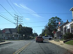
Allentown Road at Milford Square Pike in Milford Square
Bucks county - Milford Square.png
Location of Milford Square in Bucks County, Pennsylvania
USA Pennsylvania location map.svg
Red pog.svg
Milford Square
Location of Milford Square in Pennsylvania
Usa edcp location map.svg
Red pog.svg
Milford Square
Milford Square (the United States)
Coordinates: 40°26′13″N75°23′56″W / 40.43694°N 75.39889°W / 40.43694; -75.39889
Country United States
State Pennsylvania
County Bucks
Township Milford
Area
[1]
  Total0.92 sq mi (2.39 km2)
  Land0.92 sq mi (2.38 km2)
  Water0.00 sq mi (0.00 km2)
Population
 (2020) [2]
  Total1,137
  Density1,234.53/sq mi (476.78/km2)
Time zone UTC-5 (Eastern (EST))
  Summer (DST) UTC-4 (EDT)
ZIP Codes
18935 and 18951
Area code(s) 215, 267 & 445
FIPS code 42-49440

Milford Square is a census-designated place [3] in Milford Township, Bucks County, Pennsylvania, United States. It is located along PA Route 663 near the borough of Trumbauersville. As of the 2010 census, the population was 897 residents. While the village has a PO Box post office, with the ZIP code of 18935, the surrounding area uses the Quakertown ZIP Code of 18951. [4] [5]

Milford Square is located on Unami Creek, also known as Swamp Creek, which drains into the Perkiomen Creek. It was formerly known as Heistville, named after the Heist family who operated Achey's Mill and lived in, and greatly renovated, the miller's home. [6]

Campbell's Bridge was listed on the National Register of Historic Places in 1988. [7] It is also home to Achey's Bridge, the first concrete-reinforced bridge in America, which was designed by Henry Mercer and now is located on private property.

Historical population
CensusPop.Note
2020 1,137
U.S. Decennial Census [8]

See also

Related Research Articles

<span class="mw-page-title-main">Bucks County, Pennsylvania</span> County in Pennsylvania, United States

Bucks County is a county in the Commonwealth of Pennsylvania. As of the 2020 census, the population was 646,538, making it the fourth-most populous county in Pennsylvania. Its county seat is Doylestown. The county is named after the English county of Buckinghamshire. The county is part of the Southeast Pennsylvania region of the state.

<span class="mw-page-title-main">East Rockhill Township, Pennsylvania</span> Township in Pennsylvania, United States

East Rockhill Township is a township in Bucks County, Pennsylvania, United States. The original Rockhill Township was established in 1740 and was divided into East and West Rockhill Townships in 1890. The population was 5,706 at the 2010 Census. East Rockhill is part of Pennridge School District. Pennridge Airport is located in East Rockhill Township.

<span class="mw-page-title-main">Milford Township, Bucks County, Pennsylvania</span> Township in Pennsylvania, United States

Milford Township is a township in Bucks County, Pennsylvania, United States. The population was 9,902 at the 2010 census. It is home to the Quakertown interchange of the Pennsylvania Turnpike Northeast Extension, also known as Interstate 476.

<span class="mw-page-title-main">New Hope, Pennsylvania</span> Borough in Pennsylvania, United States

New Hope is a borough in Bucks County, Pennsylvania, United States. The population was 2,612 at the 2020 census. New Hope is located approximately 30 mi (48 km) north of Philadelphia, and lies on the west bank of the Delaware River at its confluence with Aquetong Creek. New Hope and neighboring Solebury and Upper Makefield townships are part of the Philadelphia metropolitan area. The two-lane New Hope–Lambertville Bridge carries automobile and foot traffic across the Delaware to Lambertville, New Jersey, on the east bank. New Hope's primary industry is tourism.

<span class="mw-page-title-main">Quakertown, Pennsylvania</span> Borough in Pennsylvania, United States

Quakertown is a borough in Bucks County, Pennsylvania, United States. As of 2020, it had a population of 9,359. The borough is 15 miles (24 km) south of Allentown and Bethlehem and 40 miles (64 km) north of Philadelphia, making Quakertown a border town of both the Delaware Valley and Lehigh Valley metropolitan areas.

<span class="mw-page-title-main">Richland Township, Bucks County, Pennsylvania</span> Township in Pennsylvania, United States

Richland Township is a township in Bucks County, Pennsylvania, United States. The population was 11,100 at the 2010 census.

<span class="mw-page-title-main">Solebury Township, Pennsylvania</span> Township in Pennsylvania, United States

Solebury Township is a township in Bucks County, Pennsylvania, United States. The population was 8,709 at the 2020 census.

<span class="mw-page-title-main">Springfield Township, Bucks County, Pennsylvania</span> Township in Pennsylvania, United States

Springfield Township is a township in Bucks County, Pennsylvania, United States. The population was 5,035 at the 2010 census.

<span class="mw-page-title-main">Tinicum Township, Bucks County, Pennsylvania</span> Township in Pennsylvania, United States

Tinicum Township is a township in Bucks County, Pennsylvania, United States. The population was 3,995 at the 2010 census.

<span class="mw-page-title-main">Saegertown, Pennsylvania</span> Borough in Pennsylvania, United States

Saegertown is a borough in Crawford County, Pennsylvania. The population was 869 at the time of the 2020 census, down from 997 at the 2010 census. It was established in 1824.

<span class="mw-page-title-main">West Mead Township, Pennsylvania</span> Township in Pennsylvania, United States

West Mead Township is a township in Crawford County, Pennsylvania, United States. The population was 5,043 at the 2020 census, down from 5,249 at the 2010 census.

<span class="mw-page-title-main">Lower Milford Township, Pennsylvania</span> Township in Pennsylvania, United States

Lower Milford Township is a township in Lehigh County, Pennsylvania, United States. The population of Lower Milford Township was 3,775 at the 2010 census. It is a suburb of Allentown in the Lehigh Valley region of eastern Pennsylvania.

<span class="mw-page-title-main">Upper Saucon Township, Pennsylvania</span> Township in Pennsylvania, United States

Upper Saucon Township is a township in Lehigh County, Pennsylvania, United States. It is part of the Lehigh Valley metropolitan area, which had a population of 861,899 and was the 68th-most populous metropolitan area in the U.S. as of the 2020 census. The township had a population of 16,973 as of the 2020 census.

<span class="mw-page-title-main">Marlborough Township, Pennsylvania</span> Township in Pennsylvania, United States

Marlborough Township is a township in Montgomery County, Pennsylvania, United States. The population was 3,178 at the 2010 census.

<span class="mw-page-title-main">Jefferson Township, Somerset County, Pennsylvania</span> Township in Pennsylvania, United States

Jefferson Township is a township in Somerset County, Pennsylvania, United States. The population was 1,428 at the 2020 census. It is part of the Johnstown, Pennsylvania, Metropolitan Statistical Area.

<span class="mw-page-title-main">Pennsylvania Route 663</span> State highway in Pennsylvania, US

Pennsylvania Route 663 (PA 663) is a 22.13-mile-long (35.61 km) state highway in Montgomery and Bucks counties in southeast Pennsylvania. Its southern terminus is at PA 100 in the borough of Pottstown and its northern terminus is at PA 309 and PA 313 in the borough of Quakertown, where the road continues eastward as PA 313. Along the way, PA 663 also passes through the borough of Pennsburg. It is called John Fries Highway between Pennsburg and Quakertown. It has an interchange with Interstate 476 at exit 44 west of Quakertown. The route was assigned in 1930, and it has had several realignments since its commissioning, including two major ones.

Wakefield is an unincorporated community and census-designated place (CDP) within Fulton Township, Lancaster County, Pennsylvania, United States. As of the 2010 census, the population was 609. It is the largest community within the "Peach Bottom" ZIP code, with the area post office on Pennsylvania Route 272, just north of town.

<span class="mw-page-title-main">Spinnerstown, Pennsylvania</span> Census-designated place in Pennsylvania, United States

Spinnerstown is a census-designated place in Milford Township, Bucks County, Pennsylvania, United States. It is located just northwest of the Quakertown interchange of I-476 with Route 663. As of the 2010 census, the population was 1,826 residents.

<span class="mw-page-title-main">Ackermanville, Pennsylvania</span> Census-designated place in Pennsylvania, United States

Ackermanville is a census-designated place located on PA Route 191 in Washington Township, Northampton County, Pennsylvania, United States. As of the 2022 American Community Survey, the village's population was 280. Ackermanville is part of the Lehigh Valley metropolitan area, which had a population of 861,899 and was the 68th-most populous metropolitan area in the U.S. as of the 2020 census. It was named for the Ackerman family.

Brick Tavern is a populated place in Milford Township, Bucks County, Pennsylvania, United States.

References

  1. "ArcGIS REST Services Directory". United States Census Bureau. Retrieved October 12, 2022.
  2. "Census Population API". United States Census Bureau. Retrieved October 12, 2022.
  3. "2010 Census". Census.gov. Retrieved August 10, 2013.
  4. "ZIP Code 18935, MILFORD SQUARE PA, U.S. ZIP Codes, Database - MILFORD SQUARE Pennsylvania PA Map". Zip-codes.com. Retrieved August 10, 2013.
  5. "Quakertown Pennsylvania ZIP Code Map Free". HipCodes.com. November 30, 2012. Archived from the original on October 29, 2013. Retrieved August 10, 2013.
  6. "History of Milford Township, Bucks County Pennsylvania". Milfordtownship.org. Retrieved August 10, 2013.
  7. "National Register Information System". National Register of Historic Places . National Park Service. July 9, 2010.
  8. "Census of Population and Housing". Census.gov. Retrieved June 4, 2016.