Hood, Pennsylvania

Last updated

Hood, Pennsylvania
Populated place
Hood, PA - Heath mills.jpg
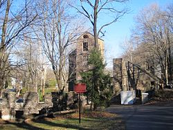
Ruins of Robert Heath Mills
USA Pennsylvania location map.svg
Red pog.svg
Hood, Pennsylvania
Location of Hood in Pennsylvania
Usa edcp location map.svg
Red pog.svg
Hood, Pennsylvania
Hood, Pennsylvania (the United States)
Coordinates: 40°21′39″N74°57′47″W / 40.36083°N 74.96306°W / 40.36083; -74.96306
Country United States
State Pennsylvania
County Bucks
Borough New Hope
Elevation
[1]
108 ft (33 m)
Time zone UTC-5 (Eastern (EST))
  Summer (DST) UTC-4 (EDT)
Area code 215
FIPS code 42-35558
GNIS feature ID 1203833

Hood is a populated place that is located in New Hope, a borough in Bucks County, Pennsylvania, United States. [2]

Contents

History

The site features ruins of the Robert Heath Mills, a grist mill built in the early 1700s. [3]

The original name of this community was Springdale. [ citation needed ]

Geography

Hood has an estimated elevation of 108 feet (33 m) above sea level and is located at the intersection of Mechanic Street and Sugan Road. Located near the settlement are Aquetong Creek and New Hope and Ivyland Railroad. [4]

See also

Springdale Historic District (New Hope, Pennsylvania)

References

  1. "Feature Detail Report for: Hood". Geographic Names Information System . United States Geological Survey, United States Department of the Interior.
  2. "Hood (in Bucks County, PA) Populated Place Profile". PA Hometown Locator. Retrieved December 18, 2015.
  3. McNealy, Terry A. (Spring 2005). "Historic New Hope, Pennsylvania". Bucks County Town & Country Living. Greater New Hope Chamber of Commerce. Retrieved December 26, 2015. [A] thousand acres of land were surveyed for a man named Robert Heath in 1700, covering the site of present-day New Hope. ... Robert Heath may well have chosen the location of his land grant because it included a stream that came to be known as Ingham Creek (from the name of a prominent landowner a century later), which provided a strong enough flow to power mills. ... A local road leading to Heath's mill is still called Sugan Road, so called for the "suggans" or saddle-bags used by farmers riding on horseback to carry their grain to the mill for grinding
  4. "Aerial view of Hood" (Map). Google Maps . Retrieved December 26, 2015.