Carversville, Pennsylvania

Last updated

Carversville, Pennsylvania
Unincorporated community
Carversville General Store.jpg
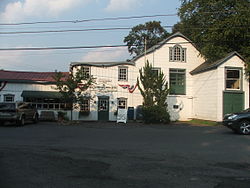
Carversville Town Square
USA Pennsylvania location map.svg
Red pog.svg
Carversville
Coordinates: 40°23′11″N75°03′46″W / 40.38639°N 75.06278°W / 40.38639; -75.06278
Country United States
State Pennsylvania
County Bucks
Township Solebury
Elevation
226 ft (69 m)
Time zone UTC-5 (Eastern (EST))
  Summer (DST) UTC-4 (EDT)
ZIP code
18913
Area code(s) 215, 267 and 445
GNIS feature ID1203228 [1]

Carversville is an unincorporated community and geographically isolated area in Solebury Township, Bucks County, Pennsylvania, United States, approximately 45 miles north of Philadelphia. It was originally a Lenape gathering placed called Aquetong (translation: "many springs") more than 300 years ago the area's land was granted to James Harrison and Joseph Pike by William Penn. The Paunacussing Creek also called Fleecydale runs through Carversville and meets the Delaware River at Lumberville.

By 1730, roads had been formed into Carversville's dense forests so that settlers could haul out wool and farm produce and bring in lumber that had been rafted down the Delaware River from northern Pennsylvania.

Carversville was originally called Indian Village, though was later named Mill Town for the presence of its mills. Its name was later contracted into Milton before finally, in 1833, being renamed Carversville in honor of the first postmaster, [2] whose last name was Carver.

Carversville was a center of commerce from its inception, and boasted enterprises such as Stovers Mill, Fretz Mill, Carver Mill, Suggin Bag Manufactury, a sash and blind mill, and the famous Roram Hat factory.

In 1859, the Excelsior Normal Institute was founded on the hill that overlooks the village. This five-story stone building became a well-known school which turned out scholars until it fell on hard times in the late nineteenth century. When teaching ended, pleasure began as the building became a resort. However, its lifespan was also short-lived. The final use for the property was as the Carversville Christian Orphanage. The building was razed in the mid-1900s.

Today, Carversville is home to some 100 residents, and is protected by a Historic District Ordinance which prevents the area from being marred by overdevelopment of new homes and businesses. The center of Carversville, nicknamed the Town Square is home to the Carversville Inn, a restaurant which dates back to 1813, the dental office of Dr. Howard Barsky, and the Carversville General Store. The Historic Carversville Society maintains an active schedule full of events for its residents, which includes Carversville Day (a town fair that includes the famed "pet parade"), Films in the Field (dated movies shown once per month during the summer that are projected on the side of the General Store), and carolling in the Square (where villagers gather in the Town Square to sing Christmas carols and visit Santa Claus).

Carversville was home to noted artist Charles Hargens famous for his cover art. Mr. Hargens painted covers for The Saturday Evening Post , Collier's , The Open Road for Boys and many western novels of the 1930s and 1940s.

In music, "Carversville" is the title of a song by the band Lincoln and during a concert in 1998, the band announced it to be specifically about Carversville, Pennsylvania.

The Bridge in Solebury Township and Carversville Historic District are listed on the National Register of Historic Places. [3]

Related Research Articles

<span class="mw-page-title-main">Bucks County, Pennsylvania</span> County in Pennsylvania, United States

Bucks County is a county in the Commonwealth of Pennsylvania. As of the 2020 census, the population was 646,538, making it the fourth-most populous county in Pennsylvania. Its county seat is Doylestown. The county is named after the English county of Buckinghamshire.

<span class="mw-page-title-main">Bristol, Pennsylvania</span> Borough in Pennsylvania, United States

Bristol is a borough in Bucks County, Pennsylvania, United States. It is located 23 miles (37 km) northeast of Center City Philadelphia, opposite Burlington, New Jersey on the Delaware River.

<span class="mw-page-title-main">Buckingham Township, Bucks County, Pennsylvania</span> Township in Pennsylvania, United States

Buckingham Township is a township in Bucks County, Pennsylvania, United States. The population was 20,075 at the 2010 census. Buckingham takes its name from Buckingham in Buckinghamshire, England. Buckingham Township was once known as Greenville and was once the historic county seat of the English Bucks County.

<span class="mw-page-title-main">Morrisville, Bucks County, Pennsylvania</span> Borough in Pennsylvania, United States

Morrisville is a borough in Bucks County, Pennsylvania, United States. It is located just below the falls of the Delaware River opposite Trenton, New Jersey. The population was 9,809 in the 2020 Census.

<span class="mw-page-title-main">New Hope, Pennsylvania</span> Borough in Pennsylvania, United States

New Hope is a borough in Bucks County, Pennsylvania, United States. The population was 2,612 at the 2020 census. New Hope is located approximately 30 mi (48 km) north of Philadelphia, and lies on the west bank of the Delaware River at its confluence with Aquetong Creek. New Hope and neighboring Solebury and Upper Makefield townships are part of the Philadelphia metropolitan area. The two-lane New Hope–Lambertville Bridge carries automobile and foot traffic across the Delaware to Lambertville, New Jersey, on the east bank. New Hope's primary industry is tourism.

<span class="mw-page-title-main">Plumstead Township, Pennsylvania</span> Township in Pennsylvania, United States

Plumstead Township is a township in Bucks County, Pennsylvania, United States. The population was 12,442 at the 2010 census.

<span class="mw-page-title-main">Solebury Township, Pennsylvania</span> Township in Pennsylvania, United States

Solebury Township is a township in Bucks County, Pennsylvania, United States. The population was 8,709 at the 2020 census.

<span class="mw-page-title-main">Yardley, Pennsylvania</span> Borough in Pennsylvania, United States

Yardley is a borough in Bucks County, Pennsylvania, United States. Yardley borders the Delaware River and Ewing, New Jersey to its east and Lower Makefield Township to its north, west, and south. The United States Post Office assigns many addresses in Lower Makefield Township the preferred city of "Yardley", although they are outside the borough. The population was 2,434 at the 2010 census. Yardley is part of the Delaware Valley metropolitan area.

<span class="mw-page-title-main">Newtown Township, Delaware County, Pennsylvania</span> Township in Pennsylvania, United States

Newtown Township, also referred to by the name of its post office of Newtown Square, is a township in Delaware County, Pennsylvania, United States. Prior to 1789, it was part of Chester County. As of the 2020 census, the population was 15,002.

<span class="mw-page-title-main">Jenkintown, Pennsylvania</span> Borough in Pennsylvania, United States

Jenkintown is a borough in Montgomery County, Pennsylvania. It is approximately 10 miles (16 km) north of Center City Philadelphia.

<span class="mw-page-title-main">Washington Crossing Historic Park</span> United States historic place

Washington Crossing Historic Park is a 500-acre (2 km2) state park operated by the Pennsylvania Department of Conservation and Natural Resources in partnership with the Friends of Washington Crossing Park. The park is divided into two sections. One section of the park, the "lower park," is headquartered in the village of Washington Crossing located in Upper Makefield Township in Bucks County, Pennsylvania. It marks the location of George Washington's crossing of the Delaware River during the American Revolutionary War.

Cuttalossa is an unincorporated hamlet in Solebury Township, just downriver from Lumberville, Pennsylvania. It sits at the confluence of a creek that runs through an unusually beautiful small valley and that feeds into the Delaware Division of the Pennsylvania Canal, an old barge canal formerly used for transporting coal and cement from Northern Pennsylvania to Philadelphia. The canal is now the Delaware Canal State Park.

<span class="mw-page-title-main">Lumberville, Pennsylvania</span> Unincorporated community in Pennsylvania, United States

Lumberville is a village on the Delaware River in Solebury Township, Bucks County, Pennsylvania, United States. It is located seven miles north of New Hope and is situated along River Road. Its ZIP Code is 18933.

<span class="mw-page-title-main">Bristol Historic District</span> Historic district in Pennsylvania, United States

The Bristol Historic District in Bristol, Pennsylvania was included on the National Register of Historic Places in 1987. The district has over 300 buildings, a few dating back to the early eighteenth century. It includes 28 acres, which is the area of the original town as laid out in 1697 and is bounded by the Delaware River, and Lincoln, Pond, Cedar, and Mill Streets. Most of the buildings are residential and only 22 are considered to be non-historic intrusions to the district.

<span class="mw-page-title-main">Bridge in Solebury Township</span> United States historic place

The Bridge in Solebury Township is an historic stone arch bridge located at Carversville in Solebury Township, Bucks County, Pennsylvania, United States. It has two spans, each 20 feet long, and was constructed in 1854. It is constructed of roughly squared stone.

<span class="mw-page-title-main">Carversville Historic District</span> Historic district in Pennsylvania, United States

Carversville Historic District is a national historic district located at Carversville, Solebury Township, Bucks County, Pennsylvania. The district includes 57 contributing buildings in the village of Carversville. The buildings include notable examples of the Late Victorian and Federal styles. Notable buildings are the Overpeck Homestead, Fred Clark Art Museum (1873), and Carversville Christian Church (1866).

<span class="mw-page-title-main">Morgan Colt</span> American metalworker and painter

Morgan Colt was an American metalworker, furniture craftsman, impressionist painter, and architect. He helped found the New Hope, Bucks County, Pennsylvania colony of painters—the leading landscape school in the United States during the early 20th–century—but was better known as a craftsman than a painter, specializing in hand–wrought iron garden furniture and fire screens. Many of his paintings were accidentally destroyed after his death.

<span class="mw-page-title-main">Aquetong Creek (Delaware River tributary)</span> River in Pennsylvania, United States

Aquetong Creek is a tributary of the Delaware River in Solebury Township and New Hope, Bucks County, Pennsylvania. Rising from the Aquetong Spring, now known as Ingham Spring, just south of the intersection of U.S. Route 202, Lower Mountain Road, and Ingham Road, it runs about 10.75 miles (17.30 km) to its confluence with the Delaware.

Paunnacussing Creek is a tributary of the Delaware River contained wholly within Bucks County, Pennsylvania in the United States. It rises from a pond north of Mechanicsville, in Buckingham Township and drains into the Delaware at Bull Island just upstream of Lumberville in Solebury Township.

George Wall (1743–1804) was an American military officer, entrepreneur, and inventor.

References

  1. "Carversville". Geographic Names Information System . United States Geological Survey, United States Department of the Interior.
  2. Richardson, John. Solebury Township Bucks County Pennsylvania, a Short History of the Township and a Report on Township Officers and Affairs. Philadelphia: Offset Service, 1958.
  3. "National Register Information System". National Register of Historic Places . National Park Service. July 9, 2010.