Fallsington, Pennsylvania

Last updated
Fallsington, Pennsylvania
Unincorporated community
FallsingtonPA StageCoachTavern.jpg
Stage Coach Tavern
USA Pennsylvania location map.svg
Red pog.svg
Fallsington
Coordinates: 40°11′14″N74°49′08″W / 40.18722°N 74.81889°W / 40.18722; -74.81889 Coordinates: 40°11′14″N74°49′08″W / 40.18722°N 74.81889°W / 40.18722; -74.81889
Country United States
State Pennsylvania
County Bucks
Township Falls
Elevation
92 ft (28 m)
Time zone UTC-5 (Eastern (EST))
  Summer (DST) UTC-4 (EDT)
ZIP code
19054
Area code(s) 215, 267 and 445
GNIS feature ID1174608 [1]

Fallsington is an unincorporated community in Falls Township, Bucks County, Pennsylvania, United States.

Contents

Geography

The latitude of Fallsington is 40.187N. The longitude is -74.819W.

It is in the Eastern Standard time zone. Elevation is 82 feet (25 m).

History

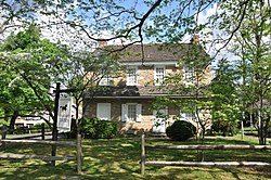
Fallsington is an example of a crossroads community typical of the 18th century, on the Kings Highway (now U.S. Route 13). The Bucks County Courthouse, established in 1663, is said to have been located in Fallsington until it was moved to Bristol in 1705. The first meetings of the Religious Society of Friends were held in the home of William Biles on Biles Island. Falls Monthly Meeting found a site for the first brick meetinghouse built in Fallsington, about 1690, on 6 acres (0.024 km2) of land that had been donated by Samuel Burgess. Also in 1690, Thomas Janney donated 72 acres (0.29 km2) of land to be used as the Quaker burial grounds for Falls Monthly Meeting. William Penn donated a tract of 120 acres (0.49 km2), for a Falls commons.

Fallsington evolved through a succession of periods in American history and architecture. Significant homes in Fallsington range from the late 17th century through the Victorian era of the mid-19th century. Fallsington was a center of commerce. A business directory of the 1860s listed blacksmiths, a butcher, carpenters, a carriage builder, a cooper, farmers, an insurance agent, machinists, physicians, a surveyor, and a wheelwright.

The growth of Fallsington continued, with the construction of homes, an inn, public buildings, stores, and small craftsmen's shops. Until the construction of Fairless Hills and Levittown, it was the largest settlement in the Township, and functioned for many years as a commercial center.

The Fallsington Historic District was listed on the National Register of Historic Places in 1972. [2]

Trivia

Related Research Articles

Bucks County, Pennsylvania County in Pennsylvania, United States

Bucks County is a county located in the Commonwealth of Pennsylvania. As of the 2010 census, the population was 625,249, making it the fourth-most populous county in Pennsylvania and the 99th-most populous county in the United States. The county seat is Doylestown. The county is named after the English county of Buckinghamshire or more precisely, its abbreviation.

Sterling, Illinois City in Illinois, United States

Sterling is a city in Whiteside County, Illinois, United States. The population was 15,370 at the 2010 census, down from 15,451 in 2000. Formerly nicknamed "Hardware Capital of the World", Sterling has long been associated with manufacturing and the steel industry.

Doylestown, Pennsylvania Borough in Pennsylvania, United States

Doylestown is a borough and the county seat of Bucks County in the U.S. state of Pennsylvania. It is located 15 miles northwest of Trenton, NJ, 25 miles south of Easton, PA, 25 miles (40 km) north of Center City Philadelphia and 65 miles (105 km) southwest of New York City. As of the 2010 census, the borough population was 8,380.

Falls Township, Bucks County, Pennsylvania Township in Pennsylvania, United States

Falls Township is a Suburban Philadelphia township in Bucks County, Pennsylvania, United States. The population was 34,300 at the 2010 census. Portions of Fairless Hills and Levittown, Pennsylvania, are located in the township. Portions of Falls Township are called Morrisville and Yardley, due to the location of the Morrisville Post Office outside the Borough of Morrisville in Falls Township. As originally Chartered in 1692, the villages of Morrisville and Tullytown were part of Falls Township. Morrisville was granted Borough status in 1804. Tullytown was erected as a Borough in 1891.

Middletown Township, Bucks County, Pennsylvania Place in Pennsylvania, United States

Middletown Township is a township in Bucks County, Pennsylvania, United States. The population was 45,436 at the 2010 census. Many sections of Levittown, Pennsylvania, are located in the southern end of the township. The municipality surrounds the boroughs of Langhorne, Langhorne Manor, Penndel and Hulmeville; much of the township beyond Levittown uses Langhorne, Pennsylvania as a mailing address.

Morrisville, Bucks County, Pennsylvania Borough in Pennsylvania, United States

Morrisville is a borough in Bucks County, Pennsylvania, United States. It is located just below the falls of the Delaware River opposite Trenton, New Jersey. The population was 8,728 at the 2010 census.

Concord Township, Delaware County, Pennsylvania Township in Pennsylvania, United States

Concord Township is a township in Delaware County, Pennsylvania, United States. The population was 17,231 at the 2010 census. It contains the unincorporated communities of Concordville and Glen Mills.

Buck Township, Luzerne County, Pennsylvania Township in Pennsylvania, United States

Buck Township is a township in Luzerne County, Pennsylvania, United States. As of the 2010 census, the population was 435, making it the least populous township in the county.

Whitemarsh Township, Montgomery County, Pennsylvania Home Rule Municipality in Pennsylvania, United States

Whitemarsh Township is a Home Rule Municipality in Montgomery County, Pennsylvania, USA. However, it maintains its former classification of "Township" in its official name. The population was 17,349 at the 2010 census.

Roxborough, Philadelphia City in Pennsylvania, United States

Roxborough is a neighborhood in the Northwest section of the city of Philadelphia, Pennsylvania. It is bordered to the southwest, along the Schuylkill River, by the neighborhood of Manayunk, along the northeast by the Wissahickon Creek section of Fairmount Park, and to the southeast by the neighborhood of East Falls. Beyond Roxborough to the northwest is Montgomery County. Roxborough's zip code is 19128. Most of Roxborough is in Philadelphia's 21st Ward.

Manayunk, Philadelphia Former borough in Pennsylvania, United States

Manayunk is a neighborhood in the section of Lower Northwest Philadelphia in the state of Pennsylvania. Located adjacent to the neighborhoods of Roxborough and Wissahickon and also on the banks of the Schuylkill River, Manayunk contains the first canal begun in the United States. The area's name is derived from the language of the Lenape Indians. In 1686-dated papers between William Penn and the Lenape, the Lenape referred to the Schuylkill River as "Manaiung", their word for "river", which literally translates as "place to drink"; the word was later altered and adopted as the town's name.

Gladwyne, Pennsylvania Unincorporated community in Pennsylvania, United States

Gladwyne is an affluent suburban community in Montgomery County, Pennsylvania, United States along the historic Philadelphia Main Line. In 2018, Gladwyne was ranked the 6th richest ZIP code in the country in a study by Bloomberg BusinessWeek. The population was 4,071 at the 2010 US census. As Gladwyne is neither an incorporated area nor a census-designated place, all data are for the ZIP code 19035, with which the community is coterminous.

Carversville, Pennsylvania Unincorporated community in Pennsylvania, United States

Carversville is an unincorporated community in Solebury Township, Bucks County, Pennsylvania, United States, approximately 45 miles north of Philadelphia. It was originally a Lenape gathering placed called Aquetong more than 300 years ago the area's land was granted to James Harrison and Joseph Pike by William Penn. The Paunacussing Creek also called Fleecydale runs through Carversville and meets the Delaware River at Lumberville.

Merry Hill is a rural unincorporated community located in Merry Hill Township in Bertie County in the U.S. state of North Carolina. This area is composed of mostly farm land. Within the town there are two schools, John P. Law Elementary School (Public), and Lawrence Academy (Private). John P. Law Elementary School was shut down in 2006 due to a diversity issue. Lawrence Academy was founded in 1968 and is located on Avoca Farm Road. In the middle of the town is the post office, with the zip code 27957. Avoca Incorporated is a large company, located where the original Avoca Plantation existed, that profits from botanical extraction. Salmon Creek twists and turns through the wooded area of Merry Hill and opens up to the Albemarle Sound. This is known as the Mouth of Salmon Creek. There is currently a golf course under construction in Merry Hill that overlooks the Mouth of Salmon and reaches out into the Albemarle Sound. The course was designed by retired professional golfer Arnold Palmer. It is expected to reach completion in the near future.

Pennsbury Manor United States historic place

Pennsbury Manor is the colonial estate of William Penn, founder and proprietor of the Colony of Pennsylvania, who lived there from 1683 to 1701. He left it and returned to England in 1701, where he died penniless in 1718. Following his departure and financial woes the estate fell into numerous hands and disrepair. Since 1939 it has been the name of a reconstructed manor on the original property.

William Yardley was an early settler of Bucks County, Pennsylvania, and is the namesake of the borough of Yardley, Pennsylvania. As a persecuted Quaker minister, Yardley and his wife, Jane moved from Ransclough, England, near Leek, Staffordshire, to Bucks County when Yardley was 50. The family arrived on September 28, 1682, on the ship Friend's Adventure with their children, Thomas, Enoch, and William, and a servant, Andrew Heath (1667-1720). Yardley subsequently purchased 500 acres (2.0 km2) of land in Lower Makefield Township in Bucks County from William Penn, who had received the land from Charles II of England to settle a debt owed Penn's father. Yardley named his tract "Prospect Farm". He served as a justice of the peace for Bucks County and became a member of the Provincial Council.

Harrison Township, Harrison County, Indiana Township in Indiana, United States

Harrison Township is one of twelve townships in Harrison County, Indiana, United States. As of the 2010 census, its population was 12,484 and it contained 5,282 housing units. Corydon, the county seat of Harrison County, is in Harrison Township.

Fallsington Historic District United States historic place

The Fallsington Historic District is a historic district in Fallsington, Pennsylvania.

William Biles was an American judge, attorney, legislator, sheriff, land speculator and merchant. Born in England and educated in law, Biles brought his family to America in 1679 and settled in what would become Falls Township, Bucks County, Pennsylvania, before the charter of William Penn. The Biles family had been persecuted for their religious dissension in England, and William became a prominent Quaker minister. "After the withdrawal of the Declaration of Indulgence dissenters were more often punished for being absent from their parish churches... Quakers were always fair game and in the following spring (1674) two of them, William Biles and Thomas Strong, were presented at the Assizes." Presumably punishment for being absent from their parish church and attending Quaker ceremonies.

Biles Creek (Delaware River tributary)

Biles Creek is a tributary of the Delaware River in Falls Township, Bucks County, Pennsylvania. Named for William Biles, who purchased the island later known as Biles Island, consisting of 309 acres (125 ha). Biles arrived in Bucks County on 12 June 1679, three years before the arrival of William Penn.

References

  1. "Fallsington". Geographic Names Information System . United States Geological Survey.
  2. "National Register Information System". National Register of Historic Places . National Park Service. July 9, 2010.