Like most of eastern Pennsylvania, present-day Doylestown was inhabited by the Lenape Indian tribe prior to European settlement of the region.
18th century
In March 1745, William Doyle, an Irish settler, obtained a license to build a tavern, then known as William Doyle's Tavern, on what is now the northwest corner of Dyers Road and Coryell's Ferry Road at present-day Main and State Streets. The tavern's strategic location at the junction of present-day U.S. Route 202, which links Norristown and New Hope, and Pennsylvania Route 611, which links Philadelphia and Easton, contributed to Doylestown's early growth.
A second inn, named Sign of the Ship, was established in 1774, built diagonally across from the Doyle Tavern. Samuel Flack was innkeeper in 1778.[3]
19th century
On January 1, 1802, a post office was established in present-day Doylestown. Charles Stewart, the first postmaster, carried letters to recipients in the bell-shaped crown of his high beaver hat as he walked about the village. When Stewart died on February 7, 1804, his son-in-law Enoch Harvey became the next postmaster. On October 9, 1804 Harvey advertised in the Pennsylvania Correspondent, published in Doylestown, of a list of letters remaining in the post office for Wm. R. Hanna, Esq., Newtown; Doct. Felix Robertson, Bucks County; Robert Wehir, Shamony, Bucks County; Robert A. Farmer, Esq., Birdsborough; Israel Childs, Buckingham.[3]
In 1815, the first church was erected; it was followed by the construction of a succession of churches for various congregations throughout the 19th century.[3]
As the population of Central and Upper Bucks County grew throughout the 18th and into the 19th century, discontent developed with the county seat's location in Newtown, where it had been since 1725. Eight petitions with a total of 184 signers were submitted to the General Assembly, some as early as 1784, requesting the move of the county seat to Doylestown. Among the signers were Andrew Armstrong, John Armstrong, John Davis, Andrew Denison, Jesse Fell, Joseph Fell, John Ingham (of Ingham Springs), Michael Frederick Kolb, Zebulon M. Pike (of Lumberton), Samuel Preston, Robert Shewell, Walter Shewell, and Fulkerd Sebring.[3]
The Pennsylvania General Assembly approved the move by an Act on February 28, 1810, and the first Court session was opened on May 11, 1813. An outgrowth of Doylestown's new courthouse was the development of "lawyers row", a collection of Federal-style offices. One positive consequence of early 19th-century investment in the new county seat was organized fire protection, which began in 1825 with the Doylestown Fire Engine Company.
A bill to erect Doylestown into a borough was introduced into Legislature in February 1830, but failed, as well as a second attempt in the session of 1832. "An Act to erect the Village of Doylestown, in the County of Bucks, into a Borough" was passed and signed into law by Governor Joseph Ritner on April 16, 1838.[3]
An electric telegraph station was built in 1846, and the North Pennsylvania Railroad completed a branch to Doylestown in 1856. The first gas lights were introduced in 1854. Because of the town's relatively high elevation and a lack of strong water power, substantial industrial development never occurred and Doylestown evolved to have a professional and residential character.[3]
During the mid-19th century, several large tracts located east of the courthouse area were subdivided into neighborhoods. The next significant wave of development occurred after the Civil War, when the 30-acre (12ha) Magill property to the southwest of the town's core was subdivided for residential lots.[citation needed]
In 1869, Doylestown established a water works. The first telephone line arrived in 1878, the same year that a new courthouse was erected. 1897 saw the first of several trolley lines connecting Doylestown with Willow Grove, Newtown, and Easton. A private sewer system and treatment plant were authorized in 1903. The borough took over and expanded sewer service to about three-quarters of the town in 1921.[citation needed]
20th century
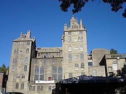
In the early 20th century, Doylestown became best known to the outside world through the "Tools of the Nation-Maker" museum of the Bucks County Historical Society. Henry Chapman Mercer constructed the reinforced concrete building in 1916 to house his collection of mechanical tools and utensils. Upon his death in 1930, Mercer also left his similarly constructed home Fonthill and adjacent Moravian Pottery and Tile Works, to be operated as a museum. The home was left on the condition that his housekeeper be allowed to live there for the rest of her life. She lived there and gave tours until the mid-1970s.[citation needed]
In 1916, Doylestown Country Club was established and still operates a private golf course and caddy program.[4]
By 1931, the advent of the automobile and improved highway service had put the last trolley line out of business as Doylestonians used the automobile as the primary means of travel within the region. The Great Depression took its toll on Doylestown; many grand old houses constructed a century earlier fell into disrepair. During the 1930s, the borough also expanded its land area to the north by admission of the tract known as the Doylestown Annex.[citation needed]
In the decade following World War II, however, Doylestown's business community boomed. During the 1940s, streets were paved for the first time in two decades and parking meters were introduced downtown in 1948. However, the postwar housing boom did not begin in earnest until the 1950s, when 550 new homes were built. The housing boom continued into the 1960s and 1970s, as more than 1,600 new homes were built during those decades and the borough's population grew from 5,917 in 1960 to 8,717 in 1980.[citation needed]
By the 1960s, the competition presented by the emergence of shopping malls proved detrimental to many local Doylestown businesses, resulting in vacant buildings and dilapidated storefronts. Bucks County Redevelopment Authority responded with a federal urban renewal scheme that called for the demolition of 27 historic buildings.[citation needed] The local business community objected to such wholesale clearance and responded with its own plan called Operation '64, the Doylestown Plan for Self-Help Downtown Renewal.[citation needed] This private initiative was successful in saving Doylestown's old buildings and historic character, while improving business at the same time. One historic landmark that could not be saved was the 80-year-old courthouse and clock tower, which was replaced by the present county complex in the early 1960s.[citation needed]
By the end of the 1980s, the downtown business district was again showing the toll of massive new competition from the latest wave of suburban shopping centers, as well as the recession that hit hardest in the northeastern states.[citation needed] In response, the borough council established a volunteer group of civic-minded representatives from business organizations, government, and the residential community to begin formulating plans for the downtown area in 1992. This effort resulted in streetscape improvements composed of cast iron street lamps and brick pavers, façade improvements and other beautification efforts, and the establishment of a Main Street Manager Program.[citation needed]
In the 1990s, the downtown area rebuilt itself largely by turning to an out-of-town audience. Doylestown had long been respected as a bucolic tourist destination. The gentry of Philadelphia and New York City, including figures associated with theater and literary in Manhattan, maintained country estates in the area and often summered in Doylestown. The Mercer Museum, Moravian Pottery and Tile Works, and the local National Shrine of Our Lady of Czestochowa brought a regular stream of short-term visitors through the area as well.[citation needed]
With charitable support, the County Theater, an art-deco-styled building, was restored and reopened showing art-house fare, and a new main library and art museum were built around the ruins of the old stone jail, across the street from the Mercer Museum. Doylestown also was designated an official resort town and was exempted from liquor license caps.[5] Empty commercial spaces soon began to be replaced with dense and vibrant bars and restaurants, contributing to a lively nightlife in Doylestown.
As the Philadelphia metropolitan area expanded from southern into central Bucks County, the fields and farms of the communities around Doylestown quickly began to sprout housing developments. This development brought thousands of people to the area, but the neighborhoods created often lacked longstanding institutions or discernible centers. Doylestown, more centrally located than the Delaware River border town of New Hope, which had traditionally served this function, was able to position itself as the regional center of culture and nightlife.[citation needed]
Archival collection and community programming are two functions of the Doylestown Historical Society, established in 1995, whose mission is "to commemorate and preserve the history of Doylestown so that its people, places and events may long be remembered."[citation needed]
Natural features of Doylestown Borough include Cooks Run and Neshaminy Creek.[7]
Climate
According to the Köppen climate classification system, Doylestown has a hot-summer, humid continental climate (Dfa). Dfa climates are characterized by at least one month having an average mean temperature ≤ 32.0°F (0.0°C), at least four months with an average mean temperature ≥ 50.0°F (10.0°C), at least one month with an average mean temperature ≥ 71.6°F (22.0°C) and no significant precipitation difference between seasons. Although most summer days are slightly humid in Doylestown, episodes of heat and high humidity can occur with heat index values > 105°F (41°C). Since 1981, the highest air temperature was 102.8°F (39.3°C) on July 22, 2011, and the highest daily average mean dew point was 75.3°F (24.1°C) on December 8, 2016. The average wettest month is July which corresponds with the annual peak in thunderstorm activity. Since 1981, the wettest calendar day was 7.11 inches (181mm) on September 16, 1999.
During winter months, the average annual extreme minimum air temperature is −1.3°F (−18.5°C).[8] Since 1981, the coldest air temperature was −12.1°F (−24.5°C) on January 22, 1984. Episodes of extreme cold and wind can occur with wind chill values < −12°F (−24°C). The average annual snowfall (Nov-Apr) is between 30 inches (76cm) and 36 inches (91cm). Ice storms and large snowstorms depositing ≥ 12 inches (30cm) of snow occur once every few years, particularly during nor’easters from December through February.
Climate data for Doylestown, Elevation 387ft (118m), 1981–2010 normals, extremes 1981–2018
As of the 2010 census, the borough was 94.8% Non-Hispanic White, 2.3% Black or African American, 0.2% Native American, 1.9% Asian, 0.1% Pacific Islander, and 1.5% were two or more races. 2.8% of the population were of Hispanic or Latino ancestry.[14][dead link]
As of the census[11] of 2000, there were 8,227 people, 3,952 households, and 1,908 families residing in the borough. The population density was 3,822.5 inhabitants per square mile (1,475.9/km2). There were 4,055 housing units at an average density of 1,884.1 per square mile (727.5/km2). The racial makeup of the borough was 95.24% White, 0.30% African American, 0.11% Native American, 1.42% Asian, 0.07% Pacific Islander, 0.43% from other races, and 0.63% from two or more races. Hispanic or Latino of any race were 2.20% of the population
There were 3,952 households, out of which 19.0% had children under the age of 18 living with them, 39.0% were married couples living together, 7.2% had a female householder with no husband present, and 51.7% were non-families. 44.4% of all households were made up of individuals, and 22.8% had someone living alone who was 65 years of age or older. The average household size was 1.98 and the average family size was 2.82.
In the borough, the population was spread out, with 16.5% under the age of 18, 5.7% from 18 to 24, 28.8% from 25 to 44, 23.5% from 45 to 64, and 25.4% who were 65 years of age or older. The median age was 44 years. For every 100 females there were 79.3 males. For every 100 females age 18 and over, there were 75.7 males.
The median income for a household in the borough was $46,148, and the median income for a family was $71,988. Males had a median income of $48,553 versus $31,703 for females. The per capita income for the borough was $32,249. About 2.5% of families and 4.4% of the population were below the poverty line, including 1.7% of those under age 18 and 9.6% of those age 65 or over.
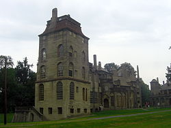
Doylestown Borough is home to three structures designed and built by Henry Chapman Mercer. The Mercer Museum, a structure built in poured concrete, is the home to Mercer's collection of early American artifacts. It also houses a collection known as "Tools of the Nation-Maker", one of the most important of its kind in the world.[15] Bucks County Historical Society also maintains the Spruance Library, a research library, adjoining the museum. Fonthill (also known as "Mercer's Castle") was Mercer's home and houses his collection of artifacts from around the world. The Moravian Pottery and Tile Works is an operational facility utilizing the tools and techniques used by Pennsylvania German potters in the 18th and 19th centuries.
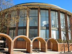
The former prison, across the street from the Mercer Museum, has been converted into the James A. Michener Art Museum. The borough also boasts a small music conservatory, writers' and artists' organizations, and other cultural activities.
Doylestown has a council-manager form of government consisting of a Mayor and a nine-member borough council. The mayor is elected at-large to a term of four years. The borough council is divided into three wards, with each ward electing three members to terms of four years. Borough council is in charge of enacting legislation, raising and spending public money, regulating land use, and providing public services. The council is required to meet once a month to conduct business. The borough council contains seven subcommittees.[16]
As of 2022, the mayor of Doylestown is Elnora "Noni" West. The borough council consists of Council President Jack O'Brien, Council Vice-President Wendy Margolis, Ben Bell, Tim Brennan, Lawrence Browne, Dennis Livrone, Joe Frederick, Jennifer Jarret, and Amy Taylor Popkin.[17][18]
The Intelligencer, a daily newspaper serving central and northern Bucks County along with nearby areas of eastern Montgomery County, is headquartered in Doylestown. In 1948, WBUX signed-on with 5,000 watts at 1570 on the AM dial. Today as WISP the station airs an All-Catholic format.
The 2002 film Signs was primarily filmed in Doylestown.[23][24]
As of 2018 there were 34.88 miles (56.13km) of public roads in Doylestown, of which 5.59 miles (9.00km) were maintained by the Pennsylvania Department of Transportation (PennDOT) and 29.29 miles (47.14km) were maintained by the borough.[25]
Doylestown Airport, a general aviation airport operated by the Bucks County Airport Authority, is located to the north of Doylestown.[36]
The Doylestown Community Bike and Hike System—founded in 1992—consists of over 25 miles (40km) of trails and side paths for pedestrians and bicycles serving both the borough of Doylestown and Doylestown Township.[37][38][39]
Utilities
Electricity and natural gas in Doylestown is provided by PECO Energy Company, a subsidiary of Exelon.[40][41][42] The Doylestown Borough Water Department provides water to the borough and some surrounding areas. Bucks County Water and Sewer owns and operates the sewer system in Doylestown.[43] Trash and recycling collection in Doylestown is provided by the borough's Public Works department.[44]
Health care
University of Pennsylvania Health System operates Doylestown Hospital on West State Street serving the borough and surrounding areas in the northern suburbs of Philadelphia. The hospital was founded in 1923. Doylestown Hospital consists of 245 beds and offers an emergency room along with various inpatient and outpatient services including cancer care, a stroke center, a chest pain center, and maternity services.[45]
123456MacReynolds, George, Place Names in Bucks County, Pennsylvania, Doylestown, Bucks County Historical Society, Doylestown, PA, 1942, Doylestown Borough.
↑"Ancient Carpenter's Tools: Illustrated and Explained, Together with the Implements of the Lumbermen, Joiner and Cabinet-Maker in use in the 18th Century", Henry Chapman Mercer, Bucks County Historical Society, 1929, ISBN0-486-40958-9 page viii.
↑"Our Schools". Central Bucks School District. Retrieved July 25, 2025.
↑"Home". Delaware Valley University. Retrieved June 20, 2025. 700 E. Butler Ave. • Doylestown, PA 18901 - Note that the City of Houston stated in 1996 that: "The U.S. Postal Service establishes ZIP codes and mailing addresses in order to maximize the efficiency of their system, not to recognize jurisdictional boundaries."
↑Longley, Francis F. (Winter 1961). "Obituary, William Alexander McCain". Assembly. Newburgh, New York: Association of Graduates, United States Military Academy. pp.82–83 – via West Point Digital Library.
↑"Gen. Wm. A. McCain". Bristol Daily Courier. Bristol, Pennsylvania. May 14, 1960. p.3 – via Newspapers.com. General William A. McCain, Retired, of 9 Easthill Drive, Doylestown...
This page is based on this Wikipedia article Text is available under the CC BY-SA 4.0 license; additional terms may apply. Images, videos and audio are available under their respective licenses.