Franklin, Pennsylvania

Last updated

Franklin, Pennsylvania
Google Submission - Franklin-1.jpg
Downtown Franklin
Flag of Franklin, Pennsylvania.png
Nickname: 
The Victorian City
Venango County Pennsylvania Incorporated and Unincorporated areas Franklin Highlighted.svg
Location of Franklin in Venango County, Pennsylvania.
USA Pennsylvania location map.svg
Red pog.svg
Franklin, Pennsylvania
Location within the U.S. state of Pennsylvania
Coordinates: 41°23′52″N79°49′53″W / 41.39778°N 79.83139°W / 41.39778; -79.83139
Country United States
State Pennsylvania
County Venango
Settled1740s
Platted 1795
Incorporated (borough)1828
Incorporated (city)1868
Named for Benjamin Franklin
Government
   Mayor Doug Baker
Area
[1]
  Total4.80 sq mi (12.44 km2)
  Land4.68 sq mi (12.11 km2)
  Water0.13 sq mi (0.33 km2)  1.70%
Population
 (2020) [2]
  Total6,077
  Density1,299.34/sq mi (501.67/km2)
   Demonym
Franklinite
  [3]
Time zone UTC–5 (EST)
  Summer (DST) UTC–4 (EDT)
ZIP Code
16323
FIPS code 42-27456
Website City website

Franklin is a city in and the county seat of Venango County, Pennsylvania, United States, located at the confluence of French Creek and the Allegheny River. The population was 6,097 in the 2020 census. [3] Franklin is part of the Oil City micropolitan area.

Contents

Franklin is known for its three-day autumn festival in October, Applefest, which attracts hundreds of thousands of visitors.

History

Oil wells near Franklin in 1873 McLaurin(1902) pic.063 ANGELL & PRENTICE's Wells below Franklin, PA, in 1873.jpg
Oil wells near Franklin in 1873

Franklin is located at the confluence of French Creek and the Allegheny River, an important site used for centuries by Native Americans. They had long before developed what became known as the Venango Path, passing from the head of French Creek north to Presque Isle Bay on Lake Erie. Via French Creek and the Allegheny River, the portage effectively linked the waterways of the Ohio River and the Great Lakes.

In 1740, Scottish fur trader John Fraser built a trading post here at Venango, the Lenape village. The French also had designs on this region.

They wanted to link their colonies of New France (Quebec) north of the Great Lakes, in Illinois Country (accessible via the Ohio River), and La Louisiane, on the lower Mississippi River. As tensions increased between France and Great Britain prior to the onset of the French and Indian War (as the North American front of the Seven Years' War was called), the French constructed four forts to control their continued access to the Venango Path and these important waterways. From north to south they were Fort Presque Isle, Fort Le Boeuf (at the south end of the portage and head of French Creek), Fort Machault, and Fort Duquesne, at the Forks of the Ohio.

In December 1753, George Washington, then a 21-year-old major in the Virginia militia, was sent to Fort Le Boeuf to warn the French that they were trespassing on British land and should leave. Although providing respite to Washington and his party, the fort commander gave him a letter suggesting that the Governor of Virginia should instead deliver his message to the French commander in Quebec, New France. [4]

The French maintained this and their other three forts, including at Fort Machault until July 1759, when they surrendered Fort Niagara to the British. At that time, the commander of Fort Presque Isle sent orders to the commanders of Fort Le Boeuf and Fort Machault to abandon their positions and return north. Before leaving, the French troops burned both of these forts to the ground to prevent their use by the British.

In 1760, the British erected Fort Venango here, replacing Fort Marchault. In 1763, Native Americans allied with the French killed many British. The British colonists had repeatedly attacked even neutral tribes, such as the Lenape, who then mostly allied with the French. After the war, the British Americans constructed Fort Franklin here, named after Benjamin Franklin.

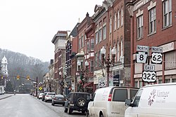
In 1787 Andrew Ellicott, who surveyed Washington, D.C., was hired to lay out the town of Franklin, which had developed around the fort. It became a trading center for a largely rural, agricultural region. Once oil was discovered in the late 19th century in nearby Titusville, Franklin became a booming oil town. After other fields were discovered in Texas and Oklahoma, and oil companies moved west, Franklin developed an industry of machinery companies. [5]

Geography

Confluence of French Creek and the Allegheny River in Franklin French creek meets allegheny river.jpg
Confluence of French Creek and the Allegheny River in Franklin

Franklin is located at 41°23′52″N79°49′53″W / 41.39778°N 79.83139°W / 41.39778; -79.83139 (41.3978, -79.8314).

According to the U.S. Census Bureau, the city has a total area of 4.7 square miles (12 km2), of which 4.6 square miles (12 km2) is land and 0.1 square miles (0.26 km2) (1.70%) is water.

Climate

Climate data for Franklin, Pennsylvania (1991–2020 normals, extremes 1897–present)
MonthJanFebMarAprMayJunJulAugSepOctNovDecYear
Record high °F (°C)73
(23)
74
(23)
90
(32)
93
(34)
97
(36)
101
(38)
106
(41)
104
(40)
100
(38)
90
(32)
81
(27)
74
(23)
106
(41)
Mean daily maximum °F (°C)33.7
(0.9)
36.3
(2.4)
45.6
(7.6)
59.7
(15.4)
70.9
(21.6)
78.7
(25.9)
82.7
(28.2)
81.2
(27.3)
74.2
(23.4)
61.4
(16.3)
49.0
(9.4)
38.1
(3.4)
59.3
(15.2)
Daily mean °F (°C)26.0
(−3.3)
27.5
(−2.5)
35.5
(1.9)
47.4
(8.6)
58.5
(14.7)
67.1
(19.5)
71.1
(21.7)
69.8
(21.0)
62.9
(17.2)
51.1
(10.6)
40.3
(4.6)
31.2
(−0.4)
49.0
(9.4)
Mean daily minimum °F (°C)18.3
(−7.6)
18.7
(−7.4)
25.4
(−3.7)
35.2
(1.8)
46.1
(7.8)
55.5
(13.1)
59.6
(15.3)
58.3
(14.6)
51.7
(10.9)
40.8
(4.9)
31.7
(−0.2)
24.3
(−4.3)
38.8
(3.8)
Record low °F (°C)−30
(−34)
−27
(−33)
−22
(−30)
0
(−18)
20
(−7)
28
(−2)
33
(1)
36
(2)
23
(−5)
15
(−9)
0
(−18)
−14
(−26)
−30
(−34)
Average precipitation inches (mm)3.27
(83)
2.66
(68)
3.36
(85)
4.15
(105)
4.00
(102)
4.86
(123)
5.32
(135)
4.24
(108)
3.94
(100)
3.76
(96)
3.41
(87)
3.36
(85)
46.33
(1,177)
Average snowfall inches (cm)17.9
(45)
11.5
(29)
8.9
(23)
1.1
(2.8)
0.0
(0.0)
0.0
(0.0)
0.0
(0.0)
0.0
(0.0)
0.0
(0.0)
0.0
(0.0)
2.6
(6.6)
11.7
(30)
53.7
(136)
Average precipitation days (≥ 0.01 in)17.914.714.214.314.513.612.311.611.214.914.116.9170.2
Average snowy days (≥ 0.1 in)9.47.54.20.60.00.00.00.00.00.01.96.029.6
Source: NOAA [6] [7]

Demographics

Historical population
CensusPop.Note
1810 159
1820 25258.5%
1830 41062.7%
1840 59545.1%
1850 93657.3%
1860 1,30339.2%
1870 3,876197.5%
1880 5,01029.3%
1890 5,82716.3%
1900 7,16723.0%
1910 9,76736.3%
1920 9,9702.1%
1930 10,2542.8%
1940 10,187−0.7%
1950 10,006−1.8%
1960 9,586−4.2%
1970 9,127−4.8%
1980 8,643−5.3%
1990 7,926−8.3%
2000 7,156−9.7%
2010 6,545−8.5%
2020 6,097−6.8%
2021 (est.)6,031 [3] −1.1%
Sources: [8] [9] [10] [2]

As of the census [9] of 2018, there were 6,078 people, 2,989 households, and 1,814 families residing in the city. The population density was 1,560.2 inhabitants per square mile (602.4/km2). There were 3,293 housing units at an average density of 709.8 per square mile (274.1/km2). The racial makeup of the city was 95.18% White, 3.19% African American, 0.04% Native American, 0.23% Asian, 0.01% Pacific Islander, 0.31% from other races, and 1.37% from two or more races. Hispanic or Latino of any race were 0.67% of the population.

There were 2,989 households, out of which 27.3% had children under the age of 18 living with them, 38.8% were married couples living together, 14.6% had a female householder with no husband present, and 39.8% were non-families. 35.5% of all households were made up of individuals, and 17.4% had someone living alone who was 65 years of age or older. The average household size was 2.27 and the average family size was 2.94.

In the city, the population was spread out, with 23.8% under the age of 18, 8.8% from 18 to 24, 25.9% from 25 to 44, 23.1% from 45 to 64, and 18.5% who were 65 years of age or older. The median age was 40 years. For every 100 females, there were 86.0 males. For every 100 females age 18 and over, there were 83.5 males.

The median income for a household in the city was $23,818, and the median income for a family was $34,718. Males had a median income of $32,912 versus $21,178 for females. The per capita income for the city was $15,234. About 13.6% of families and 17.3% of the population were below the poverty line, including 25.4% of those under age 18 and 14.4% of those age 65 or over.

Arts and culture

Franklin is home to the DeBence Antique Music World, a museum whose collection contains more than 100 antique mechanical musical instruments.

Sports

In 1903, the city was the home of the Franklin Athletic Club, one of the earliest professional football teams. That season, the team was unofficially recognized as the "US Football Champions" [11] and later won the 1903 World Series of Football, held that December at Madison Square Garden. [12] The team included several of the era's top players, such as: Herman Kerkhoff, Arthur McFarland, Clark Schrontz, Paul Steinberg, Pop Sweet, Eddie Wood, and coach Blondy Wallace. [13]

Among other sporting accomplishments, Franklin Area High School has won two state basketball championships. In 2001 and 2006, the boys team, playing in PIAA Class AAA District 10, defeated Allentown Central Catholic out of District 11 and Communications Tech from District 12 (Philadelphia Public League), respectively. [14]

Education

The Franklin Area School District currently has one high school, one middle school, and three elementary schools (Central Elementary, [15] Sandycreek Elementary, [16] and Victory Elementary [17] ) located throughout the area with an estimated 2278 students. [18]

The Valley Grove School District currently has one high school and one elementary school located in the Franklin area with an estimated 1026 students. It formerly consisted of one high school, one middle school and two elementary schools, but a consolidation and rebuilding project converted the middle school into a single elementary school that reopened in 2007. [19]

Transportation

Franklin is served by the Venango Regional Airport.

Notable people

Related Research Articles

<span class="mw-page-title-main">Armstrong County, Pennsylvania</span> County in Pennsylvania, United States

Armstrong County is a county in the Commonwealth of Pennsylvania. As of the 2020 census, the population was 65,558. The county seat is Kittanning. The county was organized on March 12, 1800, from parts of Allegheny, Westmoreland and Lycoming Counties. It was named in honor of John Armstrong, who represented Pennsylvania in the Continental Congress and served as a major general during the Revolutionary War.

<span class="mw-page-title-main">Venango County, Pennsylvania</span> County in Pennsylvania, United States

Venango County is a county in the Commonwealth of Pennsylvania. As of the 2020 census, the population was 50,454. Its county seat is Franklin. The county was created in 1800 and later organized in 1805.

<span class="mw-page-title-main">Mercer County, Pennsylvania</span> County in Pennsylvania, United States

Mercer County is a county in the Commonwealth of Pennsylvania. As of the 2020 census, the population was 110,652. Its county seat is Mercer, and its largest city is Hermitage.

<span class="mw-page-title-main">Erie County, Pennsylvania</span> County in Pennsylvania, United States

Erie County is a county in the Commonwealth of Pennsylvania. It is the northernmost county in Pennsylvania. As of the 2020 census, the population was 270,876. Its county seat is Erie. The county was created in 1800 and later organized in 1803.

<span class="mw-page-title-main">Cranberry Township, Butler County, Pennsylvania</span> Township in Pennsylvania, United States

Cranberry Township is a township in southwestern Butler County, Pennsylvania, United States. The population was 33,087 as of the 2020 census. It is one of the fastest-growing areas of the Pittsburgh metropolitan area.

<span class="mw-page-title-main">Meadville, Pennsylvania</span> City in Pennsylvania, United States

Meadville is a city in and the county seat of Crawford County, Pennsylvania, United States. The population was 13,050 at the 2020 census. The first permanent settlement in Northwestern Pennsylvania, Meadville is within 40 miles (64 km) of Erie and within 90 miles (140 km) of Pittsburgh. It is the principal city of the Meadville micropolitan area, as well as part of the larger Erie–Meadville combined statistical area.

<span class="mw-page-title-main">Oil Creek Township, Crawford County, Pennsylvania</span> Township of Titusville Pennsylvania in the United States

Oil Creek Township is a township in Crawford County, Pennsylvania, United States. The population was 1,702 at the 2020 census, a decrease from 1,877 at the 2010 census.

<span class="mw-page-title-main">Titusville, Pennsylvania</span> City in Pennsylvania, United States

Titusville is a city in the far eastern corner of Crawford County, Pennsylvania, United States. The population was 5,262 at the 2020 census. Titusville is known as the birthplace of the American oil industry and for a number of years was the leading oil-producing region in the world. It was also notable for its lumber industry, including 17 sawmills, as well as its plastic and toolmaking industries. It is part of the Meadville micropolitan area.

<span class="mw-page-title-main">Millcreek Township, Erie County, Pennsylvania</span> Township in Pennsylvania

Millcreek Township is a township in Erie County, Pennsylvania, United States. The population was 54,065 at the 2020 census, making it the 14th-largest municipality in the state. and the largest township in Western Pennsylvania.

<span class="mw-page-title-main">Waterford, Pennsylvania</span> Borough in Pennsylvania, United States

Waterford is a borough in Erie County, Pennsylvania, United States. The population was 1,475 at the 2020 census. It is part of the Erie Metropolitan Statistical Area.

<span class="mw-page-title-main">Cornplanter Township, Pennsylvania</span> Township in Pennsylvania, United States

Cornplanter Township is a township in Venango County, Pennsylvania, United States. The population was 2,317 at the 2020 census, a decrease from 2,487 at the 2010 and 2,687 at the 2000 census.

<span class="mw-page-title-main">Oil City, Pennsylvania</span> City in Pennsylvania, United States

Oil City is the largest city in Venango County, Pennsylvania, United States. Known for its prominence in the initial exploration and development of the petroleum industry, it is located at a bend in the Allegheny River at the mouth of Oil Creek. The population was 9,608 at the 2020 census, and it is the principal city of the Oil City micropolitan area.

<span class="mw-page-title-main">Warren, Pennsylvania</span> City in Pennsylvania, United States

Warren is a city in and the county seat of Warren County, Pennsylvania, United States, located along the Allegheny River. The population was 9,404 at the 2020 census. It is home to the headquarters of the Allegheny National Forest and the Cornplanter State Forest. It is also the headquarters for the Chief Cornplanter Council, the oldest continuously chartered Boy Scouts of America Council, and the catalog company Blair. Warren is the principal city of the Warren micropolitan area.

<span class="mw-page-title-main">Reynoldsburg, Ohio</span> City in Ohio, United States

Reynoldsburg is a city in Fairfield, Franklin, and Licking counties in the U.S. state of Ohio. It is a suburban community in the Columbus, Ohio metropolitan area. The population was 41,076 at the 2020 census.

<span class="mw-page-title-main">French Creek (Allegheny River tributary)</span> River in Pennsylvania, United States

French Creek is a tributary of the Allegheny River in northwestern Pennsylvania and western New York in the United States.

<span class="mw-page-title-main">Fort Le Boeuf</span>

Fort Le Bœuf was a fort established by the French during 1753 on a fork of French Creek, in present-day Waterford, in northwest Pennsylvania. The fort was part of a line that included Fort Presque Isle, Fort Machault, and Fort Duquesne.

<span class="mw-page-title-main">Fort Presque Isle</span>

Fort Presque Isle was a fort built by French soldiers in summer 1753 along Presque Isle Bay in present-day Erie, Pennsylvania, to protect the northern terminus of the Venango Path. It was the first of the French posts built in the Ohio Country, and was part of a line that included Fort Le Boeuf, Fort Machault, and Fort Duquesne.

<span class="mw-page-title-main">Fort Machault</span>

Fort Machault was a fort built by the French in 1754 near the confluence of French Creek with the Allegheny River, in northwest Pennsylvania. The fort helped the French control these waterways, part of what was known as the Venango Path from Lake Erie to the Ohio River.

<span class="mw-page-title-main">Franklin Area School District</span> School district in Pennsylvania

Franklin Area School District (FASD) is a rural, public school system headquartered in Franklin, Venango County, located in western Pennsylvania. Franklin Area School District encompasses approximately 186 square miles. It serves the residents of: Canal Township, Clinton Township, Frenchcreek Township, Irwin Township, Mineral Township, Sandycreek Township, Victory Township, along with the boroughs of: Barkeyville, Clintonville, Polk and Utica. According to 2000 federal census data, it serves a resident population of 16,598. In 2009, Franklin Area School District residents’ per capita income was $17,008, while the median family income was $39,801. In the Commonwealth, the median family income was $49,501 and the United States median family income was $49,445, in 2010.

Venango Path was a Native American trail between the Forks of the Ohio and Presque Isle, Pennsylvania, United States of America. The latter was located at Lake Erie. The trail, a portage between these important water routes, was named after the Lenape village of Venango, at the confluence of French Creek and the Allegheny River. The village site was later developed by European Americans as the small city of Franklin, Pennsylvania.

References

  1. "ArcGIS REST Services Directory". United States Census Bureau. Retrieved October 12, 2022.
  2. 1 2 "Census Population API". United States Census Bureau. Retrieved October 12, 2022.
  3. 1 2 3 "City and Town Population Totals: 2020-2021". Census.gov. US Census Bureau. Retrieved July 17, 2022.
  4. Nos racines, l'histoire vivante des Québécois, Éditions Comémorative, Livre-Loisir Ltée. p457
  5. "Franklin History". franklinpa.gov. Retrieved April 29, 2020.
  6. "NowData – NOAA Online Weather Data". National Oceanic and Atmospheric Administration. Retrieved August 8, 2021.
  7. "Station: Franklin, PA". U.S. Climate Normals 2020: U.S. Monthly Climate Normals (1991-2020). National Oceanic and Atmospheric Administration. Retrieved August 8, 2021.
  8. "Census of Population and Housing". U.S. Census Bureau. Retrieved December 11, 2013.
  9. 1 2 "U.S. Census website". United States Census Bureau . Retrieved January 31, 2008.
  10. "Incorporated Places and Minor Civil Divisions Datasets: Subcounty Resident Population Estimates: April 1, 2010 to July 1, 2012". Population Estimates. U.S. Census Bureau. Archived from the original on June 11, 2013. Retrieved December 11, 2013.
  11. PFRA Research. "Franklin's Hired Guns: 1903" (PDF). Coffin Corner. Professional Football Researchers Association: 1–3. Archived from the original (PDF) on November 26, 2010.
  12. Carroll, Bob (1980). "The First Football World Series" (PDF). Coffin Corner. 2 (Annual). Professional Football Researchers Association: 1–8. Archived from the original (PDF) on December 18, 2010.
  13. Rebel, Don (March 22, 2006). "2006 PIAA Basketball Finals Preview". MSA Sports Network. Archived from the original on September 27, 2007. Retrieved December 7, 2008.
  14. "Explore Central Elementary School in Franklin, PA".
  15. "Explore Sandycreek Elementary School in Franklin, PA".
  16. "Victory Elementary School".
  17. Info at greatschools.net
  18. "Search for Schools in Valley Grove School District". Great Schools. Retrieved December 7, 2008.
  19. Ferencz, George J. (2013). "Saddler, Frank (b Franklin, PA, 9 Sept 1864; d Brewster, NY, 25 March 1921)". In Garrett, Charles Hiroshi (ed.). The Grove Dictionary of American Music, Second Edition. Oxford University Press. ISBN   9780195314281.