Emlenton, Pennsylvania

Last updated
Emlenton, Pennsylvania
Emlenton, Pennsylvania.JPG
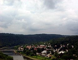
Emlenton in July 2009
Clarion County Pennsylvania Incorporated and Unincorporated areas Emlenton Highlighted.svg
Location of Emlenton in Clarion County, Pennsylvania
Map of Pennsylvania highlighting Clarion County.svg
Map showing Clarion County in Pennsylvania
USA Pennsylvania location map.svg
Red pog.svg
Emlenton
Coordinates: 41°10′42″N79°42′37″W / 41.17833°N 79.71028°W / 41.17833; -79.71028
Country United States
State Pennsylvania
Counties Clarion and Venango
Settled1820
Incorporated1859
Government
  TypeBorough Council
  MayorJudy Lentz
  Council PresidentBarry Louise
Area
[1]
  Total0.59 sq mi (1.52 km2)
  Land0.58 sq mi (1.51 km2)
  Water0.01 sq mi (0.01 km2)
Elevation
920 ft (280 m)
Population
 (2020) [2]
  Total614
  Density1,054.98/sq mi (407.50/km2)
Time zone UTC-5 (Eastern (EST))
  Summer (DST) UTC-4 (EDT)
ZIP Code
16373
Area code 724
FIPS code 42-23568
Website emlentonpaborough.com

Emlenton is a borough in Clarion and Venango counties in the U.S. state of Pennsylvania. The population was 625 at the 2010 census. [3] Of these, 617 were in Venango County, and eight were in Clarion County. The borough is home to the Emlenton Bridge on I-80, which spans the Allegheny River.

Contents

History

Emlenton is named for Emlen, the wife of John T. Sherer, one of its founders. [4]

The Emlenton Historic District was added to the National Register of Historic Places in 1997. [5]

Geography

According to the U.S. Census Bureau, the borough has a total area of 0.59 square miles (1.52 km2), of which 0.004 square miles (0.01 km2), or 0.77%, is water. [3]

Demographics

Historical population
CensusPop.Note
1870 488
1880 1,140133.6%
1890 1,126−1.2%
1900 1,1905.7%
1910 1,110−6.7%
1920 1,025−7.7%
1930 1,13710.9%
1940 986−13.3%
1950 945−4.2%
1960 844−10.7%
1970 8541.2%
1980 807−5.5%
1990 8343.3%
2000 784−6.0%
2010 625−20.3%
2020 614−1.8%
Sources: [6] [7] [8] [2]

As of the 2000 census, [7] there were 784 people, 322 households, and 200 families residing in the borough. The population density was 947.1 inhabitants per square mile (365.7/km2). There were 360 housing units at an average density of 434.9 per square mile (167.9/km2). The racial makeup of the borough was 98.85% White, 0.26% Native American, 0.38% Asian, and 0.51% from two or more races.

There were 322 households, out of which 29.2% had children under the age of 18 living with them, 45.3% were married couples living together, 12.7% had a female householder with no husband present, and 37.6% were non-families. 35.4% of all households were made up of individuals, and 17.7% had someone living alone who was 65 years of age or older. The average household size was 2.30 and the average family size was 2.94.

In the borough, the population was spread out, with 23.5% under the age of 18, 7.0% from 18 to 24, 23.3% from 25 to 44, 22.7% from 45 to 64, and 23.5% who were 65 years of age or older. The median age was 42 years. For every 100 females there were 77.8 males. For every 100 females age 18 and over, there were 77.5 males.

The median income for a household in the borough was $30,227, and the median income for a family was $40,893. Males had a median income of $33,125 versus $21,875 for females. The per capita income for the borough was $16,952. About 10.7% of families and 15.1% of the population were below the poverty line, including 19.0% of those under age 18 and 11.4% of those age 65 or over.

Emlenton Presbyterian Church Emlenton, Pennsylvania (4826050139).jpg
Emlenton Presbyterian Church

See also

Related Research Articles

<span class="mw-page-title-main">Allegheny Township, Butler County, Pennsylvania</span> Township in Pennsylvania, United States

Allegheny Township is a township in Butler County, Pennsylvania, United States. The population was 624 at the 2020 census.

<span class="mw-page-title-main">Cherry Valley, Pennsylvania</span> Borough in Pennsylvania, United States

Cherry Valley is a borough in Butler County, Pennsylvania, United States. The population was 66 at the 2010 census.

<span class="mw-page-title-main">Ashland Township, Pennsylvania</span> Township in Pennsylvania, United States

Ashland Township is a township in Clarion County, Pennsylvania, United States. The population was 1,117 at the 2020 census, an increase from the figure of 1,114 tabulated in 2010.

<span class="mw-page-title-main">Clarion Township, Clarion County, Pennsylvania</span> Township in Pennsylvania, United States

Clarion Township is a township in Clarion County, Pennsylvania, United States. The population was 3,649 at the 2020 census, a decrease from the figure of 4,116 tabulated in 2010, which was, in turn, an increase over the total of 3,273 at the 2000 census.

<span class="mw-page-title-main">Elk Township, Clarion County, Pennsylvania</span> Township in Pennsylvania, United States

Elk Township is a township in Clarion County, Pennsylvania, United States. The population was 1,432 at the 2020 census, a decrease from the figure of 1,490 tabulated in 2010.

<span class="mw-page-title-main">Foxburg, Pennsylvania</span> Borough in Pennsylvania, United States

Foxburg is a borough in Clarion County, Pennsylvania, United States. It is located along the east bank of the Allegheny River, about 2 miles (3 km) north of the mouth of the Clarion River. As of the 2020 census it had a population of 181.

<span class="mw-page-title-main">Knox, Pennsylvania</span> Borough in Pennsylvania, United States

Knox is a borough in Clarion County, Pennsylvania, United States. The population was 1,102 at the 2020 census.

<span class="mw-page-title-main">Richland Township, Clarion County, Pennsylvania</span> Township in Pennsylvania, United States

Richland Township is a township in Clarion County, Pennsylvania, United States. The population was 473 at the 2020 census, a decrease from the figure of 494 tabulated in 2010.

<span class="mw-page-title-main">Rimersburg, Pennsylvania</span> Borough in Pennsylvania, United States

Rimersburg is a borough in Clarion County in the U.S. state of Pennsylvania. The population was 945 at the 2020 census.

<span class="mw-page-title-main">Salem Township, Clarion County, Pennsylvania</span> Township in Pennsylvania, United States

Salem Township is a township in Clarion County, Pennsylvania, United States. The population was 901 at the 2020 census, an increase from the figure of 881 tabulated in 2010.

<span class="mw-page-title-main">Shippenville, Pennsylvania</span> Borough in Pennsylvania, United States

Shippenville is a borough in Clarion County, Pennsylvania, United States. The population was 446 at the 2020 census.

<span class="mw-page-title-main">St. Petersburg, Pennsylvania</span> Borough in Pennsylvania, United States

St. Petersburg is a borough in Clarion County, Pennsylvania, United States. The population was 338 at the 2020 census.

<span class="mw-page-title-main">Strattanville, Pennsylvania</span> Borough in Pennsylvania, United States

Strattanville is a borough in Clarion County, Pennsylvania, United States. The population was 537 at the 2020 census.

<span class="mw-page-title-main">Washington Township, Clarion County, Pennsylvania</span> Township in Pennsylvania, United States

Washington Township is a township in Clarion County, Pennsylvania, United States. The population was 1,869 at the 2020 census, a decrease from the figure of 1,887 tabulated in 2010.

<span class="mw-page-title-main">Townville, Pennsylvania</span> Borough in Pennsylvania, United States

Townville is a borough in Crawford County, Pennsylvania, United States. The population was 326 at the 2020 census, up from 323 at the 2010 census.

<span class="mw-page-title-main">Venango, Pennsylvania</span> Borough in Pennsylvania, United States

Venango is a borough in Crawford County, Pennsylvania, United States. The population was 210 at the 2020 census, down from 239 at the 2010 census, down from 288 in 2000.

<span class="mw-page-title-main">Corsica, Pennsylvania</span> Borough in Pennsylvania, United States

Corsica is a borough in Jefferson County, Pennsylvania, United States. The population was 357 at the 2010 census. It was named for the island of Corsica, birthplace of Napoleon Bonaparte. The mayor of the borough is Dave Leadbetter.

<span class="mw-page-title-main">Sugarcreek, Pennsylvania</span> Borough in Pennsylvania, United States

Sugarcreek is a borough in Venango County, Pennsylvania, United States. The population was 4,824 at the 2020 census. It is the largest borough by total area in all Venango County.

<span class="mw-page-title-main">Utica, Pennsylvania</span> Borough in Pennsylvania, United States

Utica is a borough that is located in Venango County, Pennsylvania, United States. The population was 184 at the time of the 2020 census.

<span class="mw-page-title-main">Allegheny-Clarion Valley School District</span> Public school district in Pennsylvania, United States

Allegheny-Clarion Valley School District (ACVSD) is a small, rural, public school district in western Pennsylvania. It spans portions of four counties and is the only Pennsylvania public school district to do so. The district is one of the 500 public school districts of Pennsylvania. The Allegheny-Clarion Valley School District encompasses approximately 121 square miles (310 km2). In Armstrong County it covers the City of Parker and Hovey Township. In Butler County it serves Allegheny Township. In Clarion County it serves the Boroughs of Emlenton, Foxburg and St. Petersburg and Perry Township and Richland Township. In Venango County it serves the Borough of Emlenton and Richland Township and Scrubgrass Township. According to 2000 federal census data, Allegheny-Clarion Valley School District serves a resident population of 5,944. By 2010, the district's population declined to 5,749 people. In 2009, the district residents' per capita income was $15,525, while the median family income was $36,867. In the Commonwealth of Pennsylvania, the median family income was $49,501 and the United States median family income was $49,445, in 2010. By 2013, the median household income in the United States rose to $52,100.

References

  1. "ArcGIS REST Services Directory". United States Census Bureau. Retrieved October 12, 2022.
  2. 1 2 "Census Population API". United States Census Bureau. Retrieved Oct 12, 2022.
  3. 1 2 "Geographic Identifiers: 2010 Census Summary File 1 (G001): Emlenton borough, Pennsylvania". U.S. Census Bureau, American Factfinder. Archived from the original on April 23, 2015. Retrieved April 23, 2015.
  4. Gannett, Henry (1905). The Origin of Certain Place Names in the United States. Govt. Print. Off. pp.  119.
  5. "National Register Information System". National Register of Historic Places . National Park Service. July 9, 2010.
  6. "Census of Population and Housing". U.S. Census Bureau. Retrieved 11 December 2013.
  7. 1 2 "U.S. Census website". United States Census Bureau . Retrieved 2008-01-31.
  8. "Incorporated Places and Minor Civil Divisions Datasets: Subcounty Resident Population Estimates: April 1, 2010 to July 1, 2012". Population Estimates. U.S. Census Bureau. Archived from the original on 11 June 2013. Retrieved 11 December 2013.