Venango County was created on March 12, 1800, from parts of Allegheny and Lycoming Counties. The name "Venango" is derived from the Native American name of the region, Onenge, meaning Otter. This was corrupted in English as the Venango River.[5] The settlement at its mouth was likewise called Venango, which since March 3, 1871, has been the South Side of Oil City. Venango County was home to an oil boom in the years following discovery of natural oil (petroleum) in the mid-1850s.
George Bissell, a Yale University chemistry professor, and Edwin L. Drake, a former railroad conductor, made the first successful use of a drilling rig on August 28, 1859, near Titusville. (Although Titusville is in Crawford County, the first oil well was drilled outside of town, less than a mile inside of the Venango County boundary) This single well soon exceeded the entire cumulative oil output of Europe since the 1650s. Within weeks, oil derricks were erected all over the area. Other oil boom towns located in Venango County included Franklin, Oil City, and the now defunct Pithole City. The principal product of the oil was kerosene.
After joining Standard Oil, Rogers invested heavily in various industries, including copper, steel, mining, and railways. The Virginian Railway is widely considered his final life's achievement. Rogers amassed a great fortune, estimated at over $100million, and became one of the wealthiest men in the United States. He was also a generous philanthropist, providing many public works for his hometown of Fairhaven, Massachusetts, and financially assisting helping such notables as Mark Twain, Helen Keller, and Dr. Booker T. Washington.
A little girl named Ida M. Tarbell, whose father was an independent producer whose small business was ruined by the South Improvement Company scheme of 1871 and the conglomerate which became Standard Oil. Introduced to each other in 1902 by their mutual friend Twain, Tarbell, who had become an investigative journalist and Rogers, who knew of her work, shared meetings and information over a two-year period which led to her epoch work, The History of the Standard Oil Company, published in 1904, which many historians feel helped fuel public sentiment against the giant company and helped lead to the court-ordered break-up of it in 1911.
The oil heritage of Venango County is commemorated by a Pennsylvania State Park and many heritage sites which help tell the story and memorialize the people of the oil boom of the late 19th and early 20th centuries.
U.S. Decennial Census[10] 1790–1960[11] 1900–1990[12] 1990–2000[13] 2010–2017[14]
Age pyramid for Venango County based on census 2000 data
2020 census
As of the 2020 census, the county had a population of 50,454 and a median age of 47.4 years. 20.1% of residents were under the age of 18 and 23.7% of residents were 65 years of age or older. For every 100 females there were 97.6 males, and for every 100 females age 18 and over there were 95.7 males age 18 and over.[15]
43.9% of residents lived in urban areas, while 56.1% lived in rural areas.[17]
There were 21,506 households in the county, of which 24.9% had children under the age of 18 living in them. Of all households, 47.5% were married-couple households, 19.3% were households with a male householder and no spouse or partner present, and 25.8% were households with a female householder and no spouse or partner present. About 30.5% of all households were made up of individuals and 15.0% had someone living alone who was 65 years of age or older.[15]
There were 26,156 housing units, of which 17.8% were vacant. Among occupied housing units, 74.7% were owner-occupied and 25.3% were renter-occupied. The homeowner vacancy rate was 2.0% and the rental vacancy rate was 9.7%.[15]
Venango County, Pennsylvania – Racial and ethnic composition Note: the US Census treats Hispanic/Latino as an ethnic category. This table excludes Latinos from the racial categories and assigns them to a separate category. Hispanics/Latinos may be of any race.
As of the 2000 census, there were 57,565 people, 22,747 households, and 15,922 families residing in the county. The population density was 85 peopleper square mile (33 people/km2). There were 26,904 housing units at an average density of 40 unitsper square mile (15/km2). The racial makeup of the county was 97.64% White, 1.09% Black or African American, 0.18% Native American, 0.23% Asian, 0.02% Pacific Islander, 0.17% from other races, and 0.67% from two or more races. 0.52% of the population were Hispanic or Latino of any race. 43.9% English or Welsh, 12.5% were of German, 11.1% American, 9.9% Irish, 8.3% Scotch-Irish, 2.8% Dutch, 2.1% Italian, and 1.6% French ancestry.
There were 22,747 households, out of which 30.40% had children under the age of 18 living with them, 55.80% were married couples living together, 9.90% had a female householder with no husband present, and 30.00% were non-families. 26.20% of all households were made up of individuals, and 12.50% had someone living alone who was 65 years of age or older. The average household size was 2.45 and the average family size was 2.93.
In the county, the population was spread out, with 24.20% under the age of 18, 7.20% from 18 to 24, 26.70% from 25 to 44, 25.10% from 45 to 64, and 16.80% who were 65 years of age or older. The median age was 40 years. For every 100 females there were 95.40 males. For every 100 females age 18 and over, there were 92.10 males.
Venango County has long been predominantly Republican. Only twice since the Civil War has the county selected a Democratic presidential candidate, and only Lyndon B. Johnson in his 1964 landslide has gained an absolute majority for the Democratic Party. In 1984, Venango County actually voted fractionally more Democratic than the nation at-large due to hostility towards Reaganomics in industrial districts, and in the 1992 and 1996 elections it came within two points and one point, respectively of voting for Democrat Bill Clinton, but by 2016 Donald Trump had gained 68.1 percent to Hillary Clinton's 26.8 percent – figures which were long typical of the county.
Voter registration
As of February 21, 2022, there are 32,319 registered voters in Venango County[26]
Pennzoil and Quaker State left the Venango area for Texas. After leaving the area they merged and stopped refining oil. They now concentrate on retail oil and automotive additives produced for them by other companies. As of 2007, the two companies only exist as brand names after the company disappeared because of successive mergers.
With global crude oil prices touching US$100 in early 2008, long-dormant interest reawakened in Venango County's remaining oil reserves, 70% undrilled by one estimate. High prices make less accessible oil deposits worth extracting. For instance, a Canadian firm proposed drilling several large mines and allowing oil to flood the tunnels.[27]
Education
Venango County, Pennsylvania public school districts
Franklin Public Library. The Franklin Public Library was founded in 1894 and has had several homes, although its current location on Twelfth Street in Franklin, Venango County, PA has been its home since 1921. The original structure on Twelfth Street was built in 1849 as a residence and required extensive renovations in 1921 to make it suitable for library use.
Communities
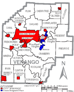
Venango County, Pennsylvania with Municipal Labels showing Cities and Boroughs (red), Townships (white), and Census-designated places (blue)
Under Pennsylvania law, there are four types of incorporated municipalities: cities, boroughs, townships, and, in at most two cases, towns. The following cities, boroughs and townships are located in Venango County:
Census-designated places are geographical areas designated by the U.S. Census Bureau for the purposes of compiling demographic data. They are not actual jurisdictions under Pennsylvania law. Other unincorporated communities, such as villages, may be listed here as well.
This page is based on this Wikipedia article Text is available under the CC BY-SA 4.0 license; additional terms may apply. Images, videos and audio are available under their respective licenses.