Clintonville, Pennsylvania

Last updated
Clintonville, Pennsylvania
Venango County Pennsylvania Incorporated and Unincorporated areas Clintonville Highlighted.svg
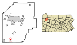
Location of Clintonville in Venango County, Pennsylvania.
USA Pennsylvania location map.svg
Red pog.svg
Clintonville
Coordinates: 41°11′58″N79°52′28″W / 41.19944°N 79.87444°W / 41.19944; -79.87444 Coordinates: 41°11′58″N79°52′28″W / 41.19944°N 79.87444°W / 41.19944; -79.87444
Country United States
State Pennsylvania
County Venango
Settled1833
Incorporated1878
Government
  TypeBorough Council
Area
[1]
  Total1.09 sq mi (2.83 km2)
  Land1.09 sq mi (2.83 km2)
  Water0.00 sq mi (0.01 km2)
Population
 (2020) [2]
  Total439
  Density402.38/sq mi (155.36/km2)
Time zone UTC-5 (Eastern (EST))
  Summer (DST) UTC-4 (EDT)
Zip code
16372
Area code 814
FIPS code 42-14376

Clintonville is a borough in Venango County, Pennsylvania, United States. The population was 437 at the 2020 census. [3]

Contents

Geography

Clintonville is located at 41°11′58″N79°52′28″W / 41.19944°N 79.87444°W / 41.19944; -79.87444 (41.199578, -79.874360). [4]

According to the United States Census Bureau, the borough has a total area of 1.1 square miles (2.8 km2), all land.

Demographics

Historical population
CensusPop.
1880 339
1890 253−25.4%
1900 2623.6%
1910 33527.9%
1920 320−4.5%
1930 35410.6%
1940 329−7.1%
1950 307−6.7%
1960 3111.3%
1970 3213.2%
1980 51259.5%
1990 5201.6%
2000 5281.5%
2010 508−3.8%
2020 437−14.0%
2021 (est.)432 [3] −1.1%
Sources: [5] [6] [7] [8] [2]

As of the census [6] of 2000, there were 528 people, 215 households, and 147 families residing in the borough. The population density was 463.5 people per square mile (178.8/km2). There were 242 housing units at an average density of 212.4 per square mile (82.0/km2). The racial makeup of the borough was 97.16% White, 1.52% African American, 0.57% Native American, 0.19% from other races, and 0.57% from two or more races. Hispanic or Latino of any race were 0.19% of the population.

There were 215 households, out of which 35.8% had children under the age of 18 living with them, 51.2% were married couples living together, 10.2% had a female householder with no husband present, and 31.6% were non-families. 27.4% of all households were made up of individuals, and 17.2% had someone living alone who was 65 years of age or older. The average household size was 2.46 and the average family size was 2.95.

In the borough the population was spread out, with 26.1% under the age of 18, 9.5% from 18 to 24, 27.5% from 25 to 44, 21.4% from 45 to 64, and 15.5% who were 65 years of age or older. The median age was 35 years. For every 100 females there were 97.8 males. For every 100 females age 18 and over, there were 90.2 males.

The median income for a household in the borough was $22,083, and the median income for a family was $29,135. Males had a median income of $23,667 versus $16,932 for females. The per capita income for the borough was $15,488. About 14.4% of families and 13.4% of the population were below the poverty line, including 16.4% of those under age 18 and 7.1% of those age 65 or over.

Related Research Articles

<span class="mw-page-title-main">Glasgow Village, Missouri</span> CDP in Missouri, United States

Glasgow Village is a census-designated place (CDP) in St. Louis County, Missouri, United States. The population was 5,429 at the 2010 census.

<span class="mw-page-title-main">Fairview, Butler County, Pennsylvania</span> Borough in Pennsylvania, United States

Fairview is a borough in Butler County, Pennsylvania, United States. The population was 198 at the 2010 census. It should not be confused with Fairview in Erie County, which carries the ZIP code 16415.

<span class="mw-page-title-main">Petrolia, Pennsylvania</span> Borough in Pennsylvania, United States

Petrolia is a borough in Butler County, Pennsylvania, United States. The population was 212 at the 2010 census.

<span class="mw-page-title-main">Lower Allen Township, Cumberland County, Pennsylvania</span> Township in Pennsylvania, United States

Lower Allen Township is a township in Cumberland County, Pennsylvania, United States. The population was 17,980 at the 2010 census.

<span class="mw-page-title-main">Polk Township, Jefferson County, Pennsylvania</span> Township in Pennsylvania, United States

Polk Township is a township in Jefferson County, Pennsylvania, United States. The population was 282 at the 2020 census. It was named for President James K. Polk.

<span class="mw-page-title-main">Summerville, Pennsylvania</span> Borough in Pennsylvania, United States

Summerville is a borough in Jefferson County, Pennsylvania, United States. The population was 528 at the 2010 census.

<span class="mw-page-title-main">Kelly Township, Union County, Pennsylvania</span> Township in Pennsylvania, United States

Kelly Township is a township in Union County, Pennsylvania, United States. The population was 3,993 at the 2020 census. The United States Penitentiary, Lewisburg is located in Kelly Township, and not in the nearby Borough of Lewisburg, whose post office serves most of the township.

<span class="mw-page-title-main">Barkeyville, Pennsylvania</span> Borough in Pennsylvania, United States

Barkeyville is a borough in Venango County, Pennsylvania, United States. The population was 186 at the 2020 census.

<span class="mw-page-title-main">Cooperstown, Pennsylvania</span> Borough in Pennsylvania, United States

Cooperstown is a borough in Venango County, Pennsylvania, United States. The population was 460 at the 2010 census.

<span class="mw-page-title-main">Pleasantville, Venango County, Pennsylvania</span> Borough in Pennsylvania, United States

Pleasantville is a borough in Venango County, Pennsylvania, United States. The population was 841 at the 2020 census, and 892 in 2010. It was an early oil 'boom town', and the population jumped from 291 to 1,598 between 1860 and 1870. But the boom soon passed, and the population shrank to 855 by 1880, and has remained fairly stable since then.

<span class="mw-page-title-main">Rouseville, Pennsylvania</span> Borough in Pennsylvania, United States

Rouseville is a borough in Venango County, Pennsylvania, United States. The population was 456 at the 2020 census.

<span class="mw-page-title-main">Sugarcreek, Pennsylvania</span> Borough in Pennsylvania, United States

Sugarcreek is a borough in Venango County, Pennsylvania, United States. The population was 4,824 at the 2020 census. It is the largest borough by total area in all Venango County.

<span class="mw-page-title-main">Utica, Pennsylvania</span> Borough in Pennsylvania, United States

Utica is a borough in Venango County, Pennsylvania, United States. The population was 184 at the 2020 census.

<span class="mw-page-title-main">Bear Lake, Pennsylvania</span> Borough in Pennsylvania, United States

Bear Lake is a borough in Warren County, Pennsylvania, United States. The population was 193 at the 2000 census.

<span class="mw-page-title-main">Clarendon, Pennsylvania</span> Borough in Pennsylvania, United States

Clarendon is a borough in Warren County, Pennsylvania, United States. The population was 450 at the 2010 census.

<span class="mw-page-title-main">Sugar Grove, Pennsylvania</span> Borough in Pennsylvania, United States

Sugar Grove is a borough in Warren County, Pennsylvania, United States. The population was 614 at the 2010 census.

<span class="mw-page-title-main">Youngsville, Pennsylvania</span> Borough in Pennsylvania, United States

Youngsville is a borough in Warren County, Pennsylvania, United States. The population was 1,729 at the 2010 census.

<span class="mw-page-title-main">Twilight, Pennsylvania</span> Borough in Pennsylvania, United States

Twilight is a borough in Washington County, Pennsylvania, United States. The population was 216 at the 2020 census.

<span class="mw-page-title-main">Madison, Pennsylvania</span> Borough in Pennsylvania, United States

Madison is a borough in Westmoreland County, Pennsylvania, United States. The population was 397 at the 2010 census. The borough was named for James Madison, 4th President of the United States.

<span class="mw-page-title-main">Oklahoma, Pennsylvania</span> Borough in Pennsylvania, United States

Oklahoma is a borough in Westmoreland County, Pennsylvania, United States. The population was 809 at the 2010 census.

References

  1. "ArcGIS REST Services Directory". United States Census Bureau. Retrieved October 12, 2022.
  2. 1 2 "Census Population API". United States Census Bureau. Retrieved Oct 12, 2022.
  3. 1 2 Bureau, US Census. "City and Town Population Totals: 2020-2021". Census.gov. US Census Bureau. Retrieved 17 July 2022.
  4. "US Gazetteer files: 2010, 2000, and 1990". United States Census Bureau. 2011-02-12. Retrieved 2011-04-23.
  5. "Census of Population and Housing". U.S. Census Bureau. Retrieved 11 December 2013.
  6. 1 2 "U.S. Census website". United States Census Bureau . Retrieved 2008-01-31.
  7. "Incorporated Places and Minor Civil Divisions Datasets: Subcounty Resident Population Estimates: April 1, 2010 to July 1, 2012". Population Estimates. U.S. Census Bureau. Archived from the original on 11 June 2013. Retrieved 11 December 2013.
  8. "Census of Population and Housing". Census.gov. Retrieved June 4, 2016.