Rouseville, Pennsylvania

Last updated
Rouseville, Pennsylvania
McLaurin(1902) pic.091 Oil Rush at Rouseville, Venango County, PA, in 1868.jpg
Rouseville during the oil boom, c. 1868
Venango County Pennsylvania Incorporated and Unincorporated areas Rouseville Highlighted.svg
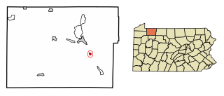
Location of Rouseville in Venango County, Pennsylvania.
USA Pennsylvania location map.svg
Red pog.svg
Rouseville, Pennsylvania
Coordinates: 41°28′17″N79°41′22″W / 41.47139°N 79.68944°W / 41.47139; -79.68944
Country United States
State Pennsylvania
County Venango
Incorporated1900
Government
  TypeBorough Council
Area
[1]
  Total0.91 sq mi (2.35 km2)
  Land0.89 sq mi (2.31 km2)
  Water0.01 sq mi (0.03 km2)
Population
 (2020) [2]
  Total456 Decrease2.svg
  Estimate 
(2021) [2]
451
  Density529.68/sq mi (204.43/km2)
Time zone UTC-5 (Eastern (EST))
  Summer (DST) UTC-4 (EDT)
Zip code
16344
Area code 814
FIPS code 42-66440

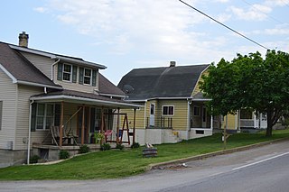
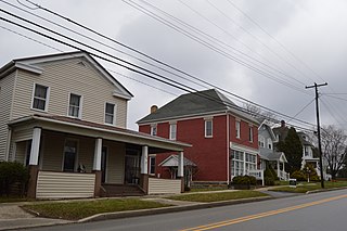
Rouseville is a borough in Venango County, Pennsylvania, United States. The population was 456 at the 2020 census. [2]

Contents

Geography

Rouseville is located at 41°28′17″N79°41′22″W / 41.47139°N 79.68944°W / 41.47139; -79.68944 (41.471398, -79.689469). [3]

According to the United States Census Bureau, the borough has a total area of 0.9 square miles (2.4 km2), of which 0.9 square mile (2.4 km2) is land and 0.04 square mile (0.1 km2) (2.15%) is water.

Demographics

Historical population
CensusPop.Note
1880 688
1900 516
1910 64825.6%
1920 81826.2%
1930 1,05929.5%
1940 998−5.8%
1950 1,0091.1%
1960 923−8.5%
1970 877−5.0%
1980 734−16.3%
1990 583−20.6%
2000 472−19.0%
2010 52310.8%
2020 456−12.8%
2021 (est.)451 [2] −1.1%
Sources: [4] [5] [6]

As of the census [5] of 2000, there were 472 people, 204 households, and 137 families residing in the borough. The population density was 520.4 inhabitants per square mile (200.9/km2). There were 240 housing units at an average density of 264.6 per square mile (102.2/km2). The racial makeup of the borough was 98.73% White, 0.42% African American and 0.85% Native American. Hispanic or Latino of any race were 0.64% of the population.

There were 204 households, out of which 22.1% had children under the age of 18 living with them, 48.5% were married couples living together, 13.2% had a female householder with no husband present, and 32.4% were non-families. 29.9% of all households were made up of individuals, and 18.1% had someone living alone who was 65 years of age or older. The average household size was 2.29 and the average family size was 2.76.

In the borough the population was spread out, with 20.8% under the age of 18, 5.9% from 18 to 24, 24.8% from 25 to 44, 23.1% from 45 to 64, and 25.4% who were 65 years of age or older. The median age was 44 years. For every 100 females there were 95.0 males. For every 100 females age 18 and over, there were 86.1 males.

The median income for a household in the borough was $22,917, and the median income for a family was $30,341. Males had a median income of $29,250 versus $18,125 for females. The per capita income for the borough was $13,286. About 16.3% of families and 25.2% of the population were below the poverty line, including 38.2% of those under age 18 and 20.1% of those age 65 or over.

Related Research Articles

<span class="mw-page-title-main">Watterson Park, Kentucky</span> City in Kentucky, United States

Watterson Park is a home rule-class city in Jefferson County, Kentucky, United States. The population was 976 at the 2010 census.

<span class="mw-page-title-main">Albion, Nebraska</span> City in Nebraska, United States

Albion is a city in and the county seat of Boone County, Nebraska, United States. The population was 1,650 at the 2010 census.

<span class="mw-page-title-main">Chalfant, Pennsylvania</span> Borough in Pennsylvania, United States

Chalfant is a borough in Allegheny County, Pennsylvania, United States. The population was 748 at the 2020 census.

<span class="mw-page-title-main">East McKeesport, Pennsylvania</span> Borough in Pennsylvania, United States

East McKeesport is a borough in Allegheny County, Pennsylvania, United States, and is part of the Pittsburgh Metro Area. The population was 2,076 at the 2020 census.

<span class="mw-page-title-main">Rankin, Pennsylvania</span> Borough in Pennsylvania, United States

Rankin is a borough in Allegheny County, Pennsylvania, United States, 8 miles (13 km) south of Pittsburgh on the Monongahela River. The borough was named after Thomas Rankin, a local landowner. Early in the 20th century, Rankin specialized in manufacturing steel and wire goods. The population increased from 3,775 in 1900 to 7,470 in 1940, and has since declined to 1,896 as of the 2020 census.

<span class="mw-page-title-main">North Apollo, Pennsylvania</span> Borough in Pennsylvania, United States

North Apollo is a borough in Armstrong County, Pennsylvania, United States. The population was 1,252 at the 2020 census.

<span class="mw-page-title-main">West Kittanning, Pennsylvania</span> Borough in Pennsylvania, United States

West Kittanning is a borough in Armstrong County, Pennsylvania, United States. The population was 1,192 at the 2020 census.

<span class="mw-page-title-main">Eau Claire, Pennsylvania</span> Borough in Pennsylvania, United States

Eau Claire is a borough in Butler County, Pennsylvania, United States. The population was 316 at the 2010 census. The name means "Clear Water" in French, and the name is pronounced as though it were spelled "U'Clare".

<span class="mw-page-title-main">Hawthorn, Pennsylvania</span> Borough in Pennsylvania, United States

Hawthorn is a borough in Clarion County, Pennsylvania, United States. The population was 482 at the 2020 census.

<span class="mw-page-title-main">Shippenville, Pennsylvania</span> Borough in Pennsylvania, United States

Shippenville is a borough in Clarion County, Pennsylvania, United States. The population was 446 at the 2020 census.

<span class="mw-page-title-main">Corsica, Pennsylvania</span> Borough in Pennsylvania, United States

Corsica is a borough in Jefferson County, Pennsylvania, United States. The population was 357 at the 2010 census. It was named for the island of Corsica, birthplace of Napoleon Bonaparte. The mayor of the borough is Dave Leadbetter.

<span class="mw-page-title-main">Ringgold Township, Jefferson County, Pennsylvania</span> Township in Pennsylvania, United States

Ringgold Township is a township in Jefferson County, Pennsylvania, United States. The population was 771 at the 2020 census.

<span class="mw-page-title-main">Cooperstown, Pennsylvania</span> Borough in Pennsylvania, United States

Cooperstown is a borough in Venango County, Pennsylvania, United States. The population was 460 at the 2010 census.
<span class="mw-page-title-main">Utica, Pennsylvania</span> Borough in Pennsylvania, United States

Utica is a borough in Venango County, Pennsylvania, United States. The population was 184 at the 2020 census.

<span class="mw-page-title-main">Bear Lake, Pennsylvania</span> Borough in Pennsylvania, United States

Bear Lake is a borough in Warren County, Pennsylvania, United States. The population was 193 at the 2000 census.

<span class="mw-page-title-main">Clarendon, Pennsylvania</span> Borough in Pennsylvania, United States

Clarendon is a borough in Warren County, Pennsylvania, United States. The population was 450 at the 2010 census.

<span class="mw-page-title-main">Export, Pennsylvania</span> Borough in Pennsylvania, United States

Export is a borough in Westmoreland County, Pennsylvania, United States, surrounded entirely by the Municipality of Murrysville. The population was 893 at the 2020 census.

<span class="mw-page-title-main">Hyde Park, Pennsylvania</span> Borough in Pennsylvania, United States

Hyde Park is a borough in Westmoreland County, Pennsylvania, United States. The population was 509 at the 2020 census.

<span class="mw-page-title-main">Madison, Pennsylvania</span> Borough in Pennsylvania, United States

Madison is a borough in Westmoreland County, Pennsylvania, United States. The population was 397 at the 2010 census. The borough was named for James Madison, fourth President of the United States.

<span class="mw-page-title-main">Meteor, Wisconsin</span> Town in Wisconsin, United States

Meteor is a town in Sawyer County, Wisconsin, United States. The population was 170 at the 2000 census.

References

  1. "2019 U.S. Gazetteer Files". United States Census Bureau. Retrieved July 28, 2020.
  2. 1 2 3 4 Bureau, US Census. "City and Town Population Totals: 2020-2021". Census.gov. US Census Bureau. Retrieved 17 July 2022.
  3. "US Gazetteer files: 2010, 2000, and 1990". United States Census Bureau. 2011-02-12. Retrieved 2011-04-23.
  4. "Census of Population and Housing". U.S. Census Bureau. Retrieved 11 December 2013.
  5. 1 2 "U.S. Census website". United States Census Bureau . Retrieved 2008-01-31.
  6. "Incorporated Places and Minor Civil Divisions Datasets: Subcounty Resident Population Estimates: April 1, 2010 to July 1, 2012". Population Estimates. U.S. Census Bureau. Archived from the original on 11 June 2013. Retrieved 11 December 2013.